Post Irma Report from Delegal Creek Marina, AICW Statute Mile 601
Security Update
By Tim Cook – timc@landings.org
Security Director
Thu, 09/21/2017 – 3:19pm
Security Update
By Tim Cook – timc@landings.org
Security Director
Thu, 09/21/2017 – 3:19pm
Our thanks to the skipper of SV Linda Jean for these realtime photos at Lands’ Marina during Irma. See /167026 for more descriptions.


Needed to be rebuilt anyway. Without loss of life this might be a blessing if the city rebuilds .
Lang’s Marina is on the north shore of the St. Marys River in downtown St. Marys. Our thanks to the skipper of the Linda Jean for this report.
Lang’s east docks completely gone. Any boats that remained on the docks were crushed during the hurricane. Lang’s west docks mostly destroyed with the exception of one floater remaining, Only two permanent sailboats survived by anchoring five miles up river.
The Blue Goose is a hostel and cafe in downtown St. Marys.
Looks like we are down. All the docks downtown gone, boats were ashore and Lang’s lost some roof.
Donna Asbell, CFO
The Blue Goose on Osborne
Hostel and Cafe
126 Osborne Street
Saint Marys, GA 31558
Lang’s east docks completely gone. Any boats that remained on the docks were crushed during the hurricane. Lang’s west docks mostly destroyed with the exception of one floater remaining, Only two permanent sailboats survived by anchoring five miles up river.
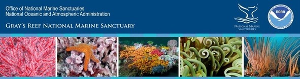
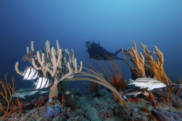
Gray’s Reef National Marine Sanctuary protects Georgia’s special live-bottom wildlife habitat in the Atlantic Ocean and along the southeastern U.S. coast, an area teeming with diversity and an abundance of marine life.

| Volunteer to be a steward of your sanctuary! |
|
The channel through Jekyll Creek seems to shift with each tide and Cruisers’ Net recommends mid to high tide passage. Fortunately, Bob and Ann Sherer, authors of 2017 ICW Cruising Guide, graciously share their 2017 survey of this Problem Stretch, complete with charts of the most treacherous segments, to assist your low tide passage through this fickle channel. Jekyll Creek is home to SALTY SOUTHEAST CRUISERS’ NET SPONSOR, Jekyll Harbor Marina.
CLICK HERE for Charting Differences at Jekyll Island
![]() Click Here To View the Cruisers’ Net’s “AICW Problem Stretches” Listing For Jekyll Creek
Click Here To View the Cruisers’ Net’s “AICW Problem Stretches” Listing For Jekyll Creek
![]() Click Here To Open A Chart View Window, Zoomed To This AICW Problem Stretch
Click Here To Open A Chart View Window, Zoomed To This AICW Problem Stretch
Click Here To View the Cruisers’ Net’s Georgia Marina Directory Listing For Jekyll Harbor Marina
Click Here To Open A Chart View Window, Zoomed To the Location of Jekyll Harbor Marina
If you are familiar with the Kilkenny Creek area and have a answer for Skipper Strozier, please let us hear from you. Kilkenny Creek Marina lies along the western shores of Kilkenny Creek, west of this stream’s intersection with Lincoln Creek, all south and west of the AICW’s marker #106.
Did Captain Jane’s parents own or operate Kilkenny camp ground?
Linda Strozier
Click Here To View the Georgia Cruisers’ Net Marina Directory Listing For Kilkenny Creek Marina
Click Here To Open A Chart View Window, Zoomed To the Location of Kilkenny Creek Marina
Gray’s Reef National Marine Sanctuary protects Georgia’s special live-bottom wildlife habitat in the Atlantic Ocean and along the southeastern U.S. coast, an area teeming with diversity and an abundance of marine life.
|
Gray’s Reef National Marine Sanctuary protects Georgia’s special live-bottom wildlife habitat in the Atlantic Ocean and along the southeastern U.S. coast, an area teeming with diversity and an abundance of marine life.
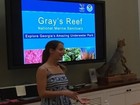
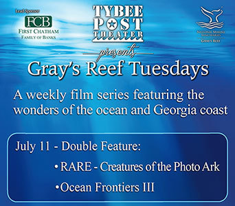
Exclusive Preview from GPB at Tybee Tuesday | |
At our next “Gray’s Reef Tuesday” on July 11, we have a treat from Georgia Public Broadcasting: a sneak peek of their upcoming 3-part television special called RARE—Creatures of the Photo Ark. RARE is a project of renowned National Geographic photographer Joel Sartore. Throughout the show, scientists and naturalists reveal surprising information about the world’s rare and at-risk animals. The preview will also include footage from right here in Georgia, with video from Georgia Outdoors naturalist Sharon Collins. We will be joined by special guest Emmalee Hackshaw from GBP who will introduce us to this wonderful experience, followed by our feature film Ocean Frontiers. Meet us at the Tybee Post Theater every Tuesday evening through August 1 for this salty, sea-loving film series! | |
A Fond Farewell to GRNMS Superintendent Sarah Fangman
The NOAA Office of National Marine Sanctuaries recently announced that our wonderful superintendent, Sarah Fangman, is leaving Gray’s Reef to become the superintendent of our sister sanctuary, Florida Keys National Marine Sanctuary. Sarah leaves Gray’s Reef in good condition; it is a healthy and productive jewel off the coast of Georgia. We hate to see her go, but we know she’ll be a valuable asset to the Keys. Please join us in saluting Sarah and all the wonderful work she has done on behalf of Gray’s Reef! Photo of Sarah diving at Gray’s Reef courtesy of Greg McFall, NOAA For more information please visit graysreef.noaa.govGray’s Reef National Marine Sanctuary, 10 Ocean Science Circle, Savannah, GA 31411 |
The AICW follows the narrow, man-made canal known as Hell Gate between the Vernon and Ogeechee Rivers. These waters have been an AICW Problem Stretch for years. Despite recent reports of shallow water at low tide, this marker by marker, rising tide report from Bob Kovach is good news and good advice for cruisers. SSECN continues to recommend mid to high tide for this passage.
Marine Trader 50 “ALLEZ!” ALL Depths are from the water line. We have a 5 ft Draft
High Tide was at 4:11 P.M. Began Transit at 3:32 North Bound at Marker #90 11.3 ft, Marker #89 11.4 Ft
Marker #87 10.4 ft Speed 7 MPH, Wind 15-22 MPH
Ended Transit 3:39 PM
Safe Cruising.
Chief Engr Bob, Onboard ALLEZ!
![]() Click Here To View the Cruisers’ Net’s “AICW Problem Stretches” Listing For Hell Gate
Click Here To View the Cruisers’ Net’s “AICW Problem Stretches” Listing For Hell Gate
![]() Click Here To Open A Chart View Window, Zoomed To This AICW Problem Stretch
Click Here To Open A Chart View Window, Zoomed To This AICW Problem Stretch
David and Jaculeyn continue sharing the log of Elske via their delightful blog, The Voyage of Elske on America’s Great Loop. A personal note regarding Elske’s title for today’s page, David is a retired Methodist minister. Today’s page recounts their passage through Problem Stretch, Hell Gate, and on to Isle of Hope Marina, A SALTY SOUTHEAST CRUISERS’ NET SPONSOR, which lies along the northwestern shores of the Waterway in the body of a hairpin turn northwest of Waterway marker #46A. Be sure to see FOCUS ON Isle of Hope Marina.
CLICK HERE FOR ELSKE’S LOG AND PHOTOS
![]() Click Here To View the Cruisers’ Net’s “AICW Problem Stretches” Listing For Hell Gate
Click Here To View the Cruisers’ Net’s “AICW Problem Stretches” Listing For Hell Gate
![]() Click Here To Open A Chart View Window, Zoomed To This AICW Problem Stretch
Click Here To Open A Chart View Window, Zoomed To This AICW Problem Stretch
Click Here To View the Cruisers’ Net’s Georgia Marina Directory Listing For Isle of Hope Marina
Click Here To Open A Chart View Window, Zoomed To the Location of Isle of Hope Marina
If you haven’t cruised this segment of the Waterway, this report from Coastal Living will definitely whet your appetite to steer that way.
Dream Trip: Boat from Fernandina Beach, Florida, to St. Simons Island, Georgia
A CRUISERS NET SPONSOR, Jekyll Harbor Marina lies along the easterly banks of the AICW’s passage through Jekyll Creek, immediately south of the 65-foot fixed bridge. Our thanks to Charles Ridley for this review and for the depth report on Jekyll Creek.
Spent 3-28-17 here. Going south in Jekyll creek at close to low tide was bad- draw 2 1/2′ and kicked mud till just south of bridge. Plenty of water at dock. Docks in good shape, decent wifi, dog friendly, restaurant on site ( many said very good but we not try it.) nice shower, rest rooms. Will plan to stay there again.
Charlie and Jackie on Traveler
Click Here To View the Cruisers’ Net’s Georgia Marina Directory Listing For Jekyll Harbor Marina
Click Here To Open A Chart View Window, Zoomed To the Location of Jekyll Harbor Marina
The Coast Guard doing more of what they do so well. Thank you Coast Guard!

News Release
Feb. 7, 2017
VIDEO AVAILABLE: Coast Guard rescues 3 fishermen after vessel catches fire near St. Catherines Island, Ga.
CLICK HERE FOR VIDEO AND REPORT
One of Claiborne’s favorite side trips along the southern Georgia portion of the AICW was to leave the Waterway at marker #34 and cruise up the Cumberland Island channel to anchor off the west side of Cumberland Island and east of Drum Point Island. Our thanks to Chris and Alyse Caldwell for this report.
Cumberland Island GA anchorage allows you access to the most pristine beach you can imagine. Wander in by dinghy from the southwestern side of the island, stroll under the canopy of trees over to the incredible dunes of the Atlantic Ocean and I will bet you encounter peacocks, goats and wild horses. This national park offers overnight camping but limits the number of daily visitors. It is a must see for us every time we traverse the east coast.
See you on the water…
Chris and Alyse Caldwell


Today we celebrate 36 years of protection for Georgia’s special live-bottom habitat that supports wildlife in the Atlantic Ocean and along the southeastern U.S. coast. With your support, Gray’s Reef National Marine Sanctuary will continue to be an area teeming with diversity and an abundance of marine life, supported by healthy habitats in clean ocean waters.
CLICK HERE FOR THE FULL ARTICLE
PLEASE NOTE: The purpose of this warning is to remind you to slow down and watch your wake wherever you are, not to assist you in avoiding law enforcement. This specific warning of a speed trap is based on hearsay and it’s the first such we’ve had in a long while. However, a word to the wise calls for carefully watching your speed and wake through this area. If you encounter speed/wake enforcement in Thunderbolt, let us hear from you. Our thanks to Steve and Barb Sipe for this report.
Have heard reports in the past few days of speeding violations being issued on the GA ICW around Thunderbolt, in the area of G33 to G37. Reports indicate LEO’s are stopping vessels for speeding/violation of no wake zones and issuing warnings and in some cases, citations with a fine of $1,000. No specific information as to the enforcement agency conducting the stops, either state or local, not USCG.
Might be worth a mention on the site as a problem area.
Steve & Barb Sipe
Solo 4303 “Maerin”
Click Here To Open A Chart View Window, Zoomed To the Location of Marker #33
I was at Thunderbolt Dec 21 and 22. i asked about an unusual or increased enforcement. The marina staff was not aware of ay such activity whatsoever.
I am a safe and courteous boater and yes I come from the north, but still south of the Mason/Dixon line.
I got stopped just passing Thunderbolt with a sog ( that’s speed over ground for you locals) of 3 kts and a good current against. I was told by GDNR sargent that I had to do idle speed! I asked him what idle speed means and he answered 1000 rpm?? I told him if I did 1000 rpm I would be doing 6 kts. and as others have said no solid object can go through a fluid without making a wave. I got a warning, but the Sabre behind me got $1000…. I must not be looking like the 1%ers!
Did you actually mean to say $1,000.00 (one thousand dollar) fine??
I try my best to abide by any no-wake or speed regulations but there are two problems:
1) Many, many waterfront homeowners have posted their own “no-wake” signs making it hard to distinguish the real ones from the fake ones. I realize that some homeowners are concerned with excessive wakes, but they have no more right to post these signs than I have to post fake speed limit signs in front of my property.
2) Wakes are subjective, rather than objective. As someone else mentioned, you can’t move a boat through the water at any speed without making some sort of wake. So when does a ripple become a wake? And in whose opinion? How do you defend yourself in court if you get a ticket? We can’t measure a wake height and neither can a LEO.
Someone mentioned boating into a current. If you’re boating into a two knot current, you have to make two knots just to stay in place and four knots to make two knots over ground.
Yes, we should do our best to boat safely and obey boating laws. Sometimes, it’s not as easy as it might seem to people other than boaters.
I agree with Tracy. They are breaking the law, increasing erosion and sometimes creating hazardous wakes. There are reasons for No Wake and speed limits.
I absolutely don’t think your publicizing the locations is a good idea.
We call it the Parade. All the boats coming from up north going to Florida. There are a lot of them and it looks like a long parade of boats. We love Yankees the talk fast drive fast have fast women and money. The drive fast thru no-wake-zones and bridges. In Georgia it is against the law to make a wake going under a bridge like the one in Thunderbolt. “No wake Idle speed only” means no bow wake you know the little bitty six inch wake your bow is making; It is a wake. When Yankees slow down from 35 knots to 25 knots that doesn’t count. Thanks for the money. It is only money go as fast as you want. Don’t worry about respecting your fellow boaters tied to the docks in those no- wake-zones
Just conjecture here: went by there in early November and someone chastised me about my wake over the VHF. I have a sail cat and was doing less than 6 kts. My wake was quite minimal. I wonder if soneone’s complaints is causing a crackdown. Let’s keep the wakes down but not get crazy unreasonable.
Why should we warn them? If they are speeding they need to learn a lesson. #noradardetectors
I couldn’t agree more. How about just a general reminder. If you are caught violating any speed or wake law, you are subject to a fine.
Because No Wake is ambiguous at best. You cannot move a solid thru a liquid without creating a wake. Add to that a full flood tide on the nose and the Slow Speed – No Wake issue is subjective. That’s how I talked my way out of a citation near Vernon View.
Congratulations, you got lucky. Keep pushing the limits and your luck will run out.
That’s total nonsense! You need to slow down, period!
Captain Wes is referring to a narrow stretch of Waterway northwest of Dolbow Island off Altamaha Sound and is responding to an earlier report of shoaling in Little Mud River, see /161445.
Another area to keep a close eye on is just south of the little mud river starting around FL 4s “202” to daymark “206” passed through about 2 hrs after low water and bumped in the middle of the channel and the boat behind bumped as well, that was a surprise! Luckily just mud…. Both of us draft 5′-5″ were on plane so calculate how you like, I lose about foot [to 4’5″] while on plane. Like Terry I was transiting this same area the same day. I was aware of what lurked ahead as I’ve transited these waters for 15 years now, it always has my full attention!!!
Wes
Click Here To Open A Chart View Window, Zoomed To the Location of Shoaling
Today’s Waterway Guide reports shoaling at Marker #60 in Cumberland Dividings, a SSECN Problem Stretch, where channel shifting at the Waterway/Brickhill River intersection is perennial. For good advice on this Problem Stretch, go to: /153352
CLICK HERE FOR WATERWAY GUIDE’S REPORT
![]() Click Here To View the Cruisers’ Net’s “AICW Problem Stretches” Listing For the Cumberland Dividings
Click Here To View the Cruisers’ Net’s “AICW Problem Stretches” Listing For the Cumberland Dividings
![]() Click Here To Open A Chart View Window, Zoomed To This AICW Problem Stretch
Click Here To Open A Chart View Window, Zoomed To This AICW Problem Stretch
Just went through here and there is severe shoaling on the western side of the channel.
Little Mud River is almost universally acknowledged to be the worst section of the entire Waterway from Norfolk to Miami. This AICW Problem Stretch lies some 21 statute miles north of Brunswick, Georgia. SSECN continues to recommend navigating this stretch at mid to high tide only. Our thanks to yacht delivery Captain Terry for this newest update. For a comprehensive report from Little Mud River, go to /?p=128659
Navigated Mud River on Nov 30 boat 48 Viking, kicked up plenty mud, many seagulls following wake.
50 ft Sport Fish hi and dry aground, missed the turn, soft mud, Sea Tow pulled off mud flat, no damage to boat or running gear.
Terry
12/8 Follow-up:
Larry, there were four boats traveling together, I was on Lockout a 48 Viking en route from Manasquan NJ to Palm Beach, Sea Tow came out and pulled him out after the tide came in, it was around 15:48 Dead low tide (7ft tide swing). We all stayed over at St. Simon’s Island and met for dinner. There was virtually no damage to the 54 Sport Fish and the Captain had around 40 years experience. I will not mention the name of the boat due to respect. Remember it can happen to anyone. If it has not happened, with time it is certain to happen.
Terry
![]() Click Here To View the Cruisers’ Net’s “AICW Problem Stretches” Listing For Little Mud River
Click Here To View the Cruisers’ Net’s “AICW Problem Stretches” Listing For Little Mud River
![]() Click Here To Open A Chart View Window, Zoomed To This AICW Problem Stretch
Click Here To Open A Chart View Window, Zoomed To This AICW Problem Stretch
Another area to keep a close eye on is just south of the little mud river starting around FL 4s “202” to daymark “206” passed through about 2 hrs after low water and bumped in the middle of the channel and the boat behind bumped as well, that was a surprise! Luckily just mud…. Both of us draft 5′-5″ were on plane so calculate how you like, I loose about foot while on plane. Like Terry I was transiting this same area the same day. I was aware of what lurked ahead as I’ve transited these waters for 15 years now, it always has my full attention!!!
Wes


Be the first to comment!