CRUISERS NET
Cruisers Helping Cruisers
Comprehensive cruising resource for the Intracoastal Waterways
from Norfolk to the Northern Gulf and Bahamas.
from Norfolk to the Northern Gulf and Bahamas.
FREE to use due to the generosity of our sponsors - please patronize them
LNM: REMINDER: AICW MM 240 New Onslow Beach Bridge Construction Underway, Camp Lejeune, NC
This construction, with the usual ICW obstructions and restrictions, will continue until Feb 2025.
NC – ATLANTIC INTRACOASTAL WATERWAY (AICW) – NORTH CAROLINA CUT
Atlantic Intracoastal Waterway – Onslow Beach Swing Bridge – Construction activities, which began in October 2022, and are expected to finish in February 2025. Work will be on-going from 7 a.m. through 7 p.m.; Monday through Friday, excluding Government holidays. To facilitate construction of the new bridge fender system, a work barge will be placed in the navigation channel from 8 a.m. to noon, and 1 p.m. to 5 p.m.; Monday through Friday, excluding Government Holidays from January 5, 2023, through February 28, 2023. During construction of the new bridge fendering system vessels with beams less than 20 feet may transit the bridge at any time and vessels with beams greater than 20 feet should adjust their voyage plan to transit the bridge outside working hours or between the hour of noon to 1 p.m. Vessels with a beam greater than 20 feet unable to adjust their voyage plan between the hour of noon to 1 p.m., may transit the bridge during working hours, if at least 24 hours’ notice is given. Two barges, support vessel, and crew boat will be operating or stationed in the vicinity of the existing and new bridge. Temporary work platforms will be in place for the duration of construction of the new bridge and demolition of the existing bridge. Mariners should navigate the waterway with extreme caution and due regard for prevailing conditions on the waterway. Barge and vessels may be reached on VHF-FM channel 13 and 16 when work is in progress or vessels are operating the area. Mariners should use caution when transiting the area. (CT)
Click Here To View the North Carolina Cruisers Net Bridge Directory Listing For Onslow Beach Bridge
Click Here To Open A Chart View Window, Zoomed To the Location of Onslow Beach Bridge
Be the first to comment!
LNM: Pamlico Sound, Lighted Buoy 12A Off-Station, Hatteras, NC
This inshore lighted buoy helps mark the channel to Hatteras Village.

HATTERAS INLET CHANNEL LIGHTED BUOY 12A, (LLNR 28732.1 [35°12.3290N / 075°43.8856W, 35.205484 / -75.731426]), REPORTED OFF STATION.
Be the first to comment!
LNM: AICW MM 246, Live Fire Drills, New River Restricted Areas, NC

Click here for SCHEDULED/CAMP LEJUNE MILOPS08-14 JAN 24/HAZ OPS/SEC NC BNM 0003-24
Be the first to comment!
LNM: AICW MM 246, Live-Fire Drills, New River Restricted Areas, NC
Click link below for restrictions:
SAFETY/NC – NEW RIVER – FIRING EXERCISES FROM 15 AUG TO 21 AUG 2022/MARINE EVENT/SEC NC BNM 0299-22
Be the first to comment!
LNM: BOLO Missing Boater, South River, NC
South River extends southward of the Neuse River east of Adams Creek.
News Release U.S. Coast Guard 5th District Mid-Atlantic
Contact: 5th District Public Affairs
Office: (757) 398-6272
After Hours: (757) 295-8435
5th District online newsroomCoast Guard searches for missing boater in Pamlico Sound, North Carolina
WILMINGTON, N.C. — The Coast Guard is searching Pamlico Sound for a missing boater Wednesday after he did not return to shore as expected Tuesday evening.
The missing boater has been identified as 38-year-old John Hess, from Buxton.
Watchstanders at the Coast Guard Sector North Carolina command center received notification of the situation from Carteret County Emergency Dispatch at 10:15 a.m. Wednesday.
It was relayed that Hess took a friend’s 23-foot boat from a private residence in Beaufort onto the South River at about 4:30 p.m Tuesday and did not return at night as expected.
The boat’s owner searched for Hess overnight with no results, then alerted authorities.
A Coast Guard Air Station Elizabeth City MH-60 Jayhawk Helicopter crew and response boat crews from Coast Guard Station Hatteras Inlet and Coast Guard Station Hobucken are searching for Hess.
Also assisting in the search are personnel from the North Carolina Wildlife Resources Commission, Harkers Island Fire Department, North Carolina Marine Patrol, and the South River-Merrimon Fire Department.
Anyone with additional information regarding this case should contact the Sector North Carolina command center at 910-343-3880.
-USCG-
Be the first to comment!
LNM: near AICW MM 294 Inlets ATONs Relocated, Carolina Beach Inlet, NC
1. THE FOLLOWING AIDS TO NAVIGATION HAVE BEEN RELOCATED TO MARK BEST WATER.
A. CAROLINA BEACH INLET BUOY 1 (LLNR 30265 [34°4.8332N / 077°51.7038W, 34.080553 / -77.861730]) RELOCATED DUE TO APPROXIMATE POSITION 34-04-52.681N 077-51-43.064W (34°4.8780N / 077°51.7177W, 34.081300 / -77.861962) .
B. CAROLINA BEACH INLET BUOY 2 (LLNR 30270 [34°4.9112N / 077°51.7151W, 34.081854 / -77.861919]) RELOCATED DUE TO APPROXIMATE POSITION 34-04-54.164N 077-51-43.252W (34°4.9027N / 077°51.7208W, 34.081712 / -77.862014) .
C. CAROLINA BEACH INLET BUOY 3 (LLNR 30275 [34°4.9340N / 077°52.0313W, 34.082233 / -77.867189]) RELOCATED DUE TO APPROXIMATE POSITION 34-04-55.265N 077-51-59.067W (34°4.9211N / 077°51.9844W, 34.082018 / -77.866407) .
D. CAROLINA BEACH INLET BUOY 5 (LLNR 30285 [34°4.9558N / 077°52.4033W, 34.082597 / -77.873389]) RELOCATED DUE TO APPROXIMATE POSITION 34-04-57.617N 077-52-26.132W (34°4.9603N / 077°52.4356W, 34.082671 / -77.873926) .
E. CAROLINA BEACH INLET BUOY 6 (LLNR 30290 [34°4.9769N / 077°52.1887W, 34.082949 / -77.869812]) RELOCATED DUE TO APPROXIMATE POSITION 34-04-58.402N 077-52-29.135W (34°4.9733N / 077°52.4856W, 34.082889 / -77.874760) .
F. CAROLINA BEACH INLET BUOY 7 (LLNR 30295 [34°4.9364N / 077°52.5247W, 34.082273 / -77.875412]) RELOCATED DUE TO APPROXIMATE POSITION 34-04-51.816N 077-52-36.454W (34°4.8636N / 077°52.6076W, 34.081060 / -77.876793) .
G. CAROLINA BEACH INLET BUOY 8 (LLNR 30300 [34°4.9768N / 077°52.4621W, 34.082946 / -77.874369]) RELOCATED DUE TO APPROXIMATE POSITION 34-04-46.954N 077-52-46.676W (34°4.7825N / 077°52.7779W, 34.079709 / -77.879632) .Be the first to comment!
LNM: AICW MM 246, Live-Fire Drills, New River Restricted Areas, NC
Click link below for restrictions:
SAFETY/NC – NEW RIVER – FIRING EXERCISES FROM 01 AUG TO 07 AUG 2022/MARINE EVENT/SEC NC BNM 0283-22
Be the first to comment!
LNM: MSIB: AICW MM 246 Military Operations, New River Restricted Areas, NC
Live-fire drills in the New River restricted areas, inshore and offshore, are associated with Marine Base Camp Lejeune and, as indicated in the notice below, these areas are closed to navigation and restrictions will continue for some time. Closures of the ICW may occur in the area.
SAFETY/MILITARY OPERATIONS/HAZARD/SEC NC BNM 0175-22
Be the first to comment!
LNM: Hatteras Inlet, Buoy 18A Added, Pamlico Sound, NC
This channel buoy is the east side of the channel connecting the Inlet with the maintained channel into Hatteras Village.
THE FOLLOWING AID TO NAVIGATION HAS BEEN ESTABLISHED.
- HATTERAS INLET CHANNEL BUOY 18A (LLNR 28761 [35°12.5026N / 075°43.1635W, 35.208376 / -75.719391]) HAS BEEN ESTABLISHED IN APPROX POSIT 35-12-30.153N, 075-43-09.806W (35°12.5026N / 075°43.1635W, 35.208376 / -75.719391)
Be the first to comment!
LNM: AICW MM 205 Light 2 Destroyed, Morehead City, NC
This ICW light is on the north side of the Waterway’s passage through Morehead City Harbor.
BOGUE SOUND LT 2 (LLNR 38630 [34°42.7728N / 076°42.8976W, 34.712880 / -76.714960]) RPTD DESTROYED. AREA SPONSORING MARINA
Click Here To Open A Chart View Window, Zoomed To the Location of Morehead City Yacht Basin
Be the first to comment!
LNM: Barney Slough Lighted Buoy 6 Missing, Pamlico Sound, NC
Barney Slough is the northernmost of two channels connecting Hatteras with Pamlico Sound. This shoaling appears to be on the southwest side of the channel.
BARNEY SLOUGH CHANNEL LIGHTED BUOY 6 (LLNR 28722.3 [35°13.8137N / 075°47.6084W, 35.230229 / -75.793473]) IS MISSING. Be the first to comment!
LNM: near AICW MM 270 Shoaling, Old Topsail Creek, New Topsail Inlet, NC
Old Topsail Creek connects New Topsail Inlet with the Waterway at Mile 270. Buoys 1 and 2 are inshore, on the northeast side of the inlet. LLNRs given below are incorrect.
THE SHOAL ADJACENT TO OLD TOPSAIL CREEK BUOYS 1(LLNR 30032 [34°20.7287N / 077°39.9956W, 34.345478 / -77.666594]) AND 2 (LLNR
30033) HAS STARTED TO CLOSE OFF THE ENTERANCE TO THE CREEK. DEPTHS BETWEEN THE
AIDS WAS OBSERVED TO 5 FT AND BELOW ACROSS THE ENTIRE CHANNEL. ALL MARINERS ARE ADVISED TO TRANSIT WITH EXTREME CAUTION.Be the first to comment!
LNM: AICW MM 246, Live-Fire Drills, 06 – 12 Sep, New River Restricted Areas, NC
These live-fire drills in the New River restricted areas, inshore and offshore, are associated with Marine Base Camp Lejeune and, as indicated in the notice below, these areas are closed to navigation and restrictions will continue for some time.
Click here for Restricted Areas
Be the first to comment!
LNM: NOAA: Saildrones to Operate on Seacoast of NC, SC, GA, FL
These orange 9.5 ft tall, 23ft unmanned surface vessels will have a white, all-round light and radar reflector. Speed is 1.5kts. NOAA is requesting greater than 500 meters stand-off.
NC – SC – GA – FL – SEACOAST – UNMANNED SURFACE RESEARCH VEHICLE
Saildrone, Inc. will be operating uncrewed Surface Vehicles called Saildrones for the purpose of oceanographic and fisheries data collection. Two Saildrones will operate from Jacksonville, FL on July 23rd. Of the two Saildrones deployed from Jacksonville, FL, one will operate in inshore and offshore waters off the coast of North Carolina throughout the summer to approximately November 15, 2021. Chart 11520 LNM 28/21


Comments from Cruisers (1)
-
Glad to hear this news. I won't even consider picking a race although it would be tempting @ 1.5 kts.
Catboat driver
-
LNM: AICW MM 246, Live-Fire Drills, 06 June, – June 13, New River Restricted Areas, NC
These live-fire drills in the New River restricted areas, inshore and offshore, have been ongoing since 2019 and, as indicated in the notice below, these areas are closed to navigation and restrictions will continue for some time.
Click here for Restricted Areas
Be the first to comment!
LNM: AICW MM 270-280 Buoys 99, 99A, 121 and 121A Relocated, Middle Sound, NC
These ICW buoys are on the southeast shoulder of the Waterway south of its intersection with Howards Creek.
- THE FOLLOWING AIDS TO NAVIGATION HAVE BEEN RELOCATED TO MARK BEST WATER.
- NEW RIVER – CAPE FEAR RIVER BUOY 99 (LLNR 39547 [34°21.5792N / 077°40.3919W, 34.359653 / -77.673199]) HAS BEEN RELOCATED TO POSITION 34-21-34.718N, 077-40-23.369W (34°21.5786N / 077°40.3895W, 34.359644 / -77.673158) .
- NEW RIVER – CAPE FEAR RIVER BUOY 99A (LLNR 39548 [34°21.2979N / 077°40.8884W, 34.354965 / -77.681474]) HAS BEEN RELOCATED TO POSITION 34-21-15.729N, 077-40-54.988W (34°21.2621N / 077°40.9165W, 34.354369 / -77.681941) .
- NEW RIVER – CAPE FEAR RIVER BUOY 121 (LLNR 39597 [34°15.0071N / 077°46.9064W, 34.250118 / -77.781774]) HAS BEEN RELOCATED TO POSITION 34-14-58.624N, 077-46-56.130W (34°14.9771N / 077°46.9355W, 34.249618 / -77.782258) .
- NEW RIVER – CAPE FEAR RIVER BUOY 121A (LLNR 39598 [34°14.9245N / 077°46.9776W, 34.248742 / -77.782960]) HAS BEEN RELOCATED TO POSITION 34-14-56.380N, 077-46.58(34°14.9396N / 077°46.5800W, 34.248994 / -77.776333) -057W.
Be the first to comment!
LNM: Dredging Underway at Hatteras Inlet, NC
After numerous complications with dredging the South Ferry Channel, the Army Corps of Engineers reported to the Dare County Waterways Commission at its Monday meeting that the hopper dredge Murden has finally started work removing the problem shoal.
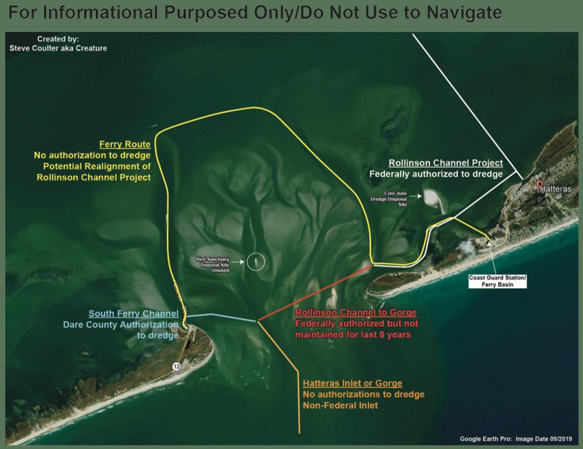
The federal authorization status of various areas in Hatteras Inlet, as compiled by Waterways Commission Chair Steve “Creature” Coulter.
Dredging Underway at Hatteras Inlet
Coastal Review OnlineBe the first to comment!
LNM: Fifth District Maritime Safety Information Upgrade
Mariners may visit the NAVCEN website and subscribe for email delivery of BNMs.
NJ – PA – DE – MD – DC – VA – NC – US COAST GUARD 5TH DISTRICT BROADCAST NOTICE TO MARINERS
The U.S. Coast Guard Navigation Center (NAVCEN) has completed its Maritime Safety Information (MSI) project upgrade to offer Broadcast Notice to Mariners (BNM) to mariners via email in addition to voice radio broadcasts. The online subscription service is in addition to the standard BNM broadcasts over VHF radio that previously, were the only way to receive this vital navigational information. Mariners can now use the subscription service to plan for underway periods and receive updates to Aids to Navigation and navigational hazards in near real time without having to wait on scheduled VHF broadcasts.
Mariners may visit the NAVCEN website and subscribe for email delivery of BNMs. https://www.navcen.uscg.gov/?pageName=feeds. BNMs are organized by Coast Guard Sector and mariners can subscribe to one, or more Fifth District Sectors. It is also recommended that you subscribe to the “5th Coast Guard District (dpw)” BNMs and the “Atlantic Hazardous Weather Outlook”. Additionally, NAVCEN has developed an online, filterable, BNM archive that is available to the public. 5th District BNMs can be viewed and downloaded from this database on the NAVCEN website at: https://www.navcen.uscg.gov/bnmmessages/DistrictSearchV1.php?d=5&i=4html. For any questions regarding these services contact the NIS Watch at 703-313-5900. LNM 13/21Be the first to comment!
LNM: Right Whales Sighted near Outer Banks, NC
For our offshore mariners! 10 knots or less!
RIGHT WHALE NAVIGATIONAL WARNING
NOAA HAS ANNOUNCED A DYNAMIC MANAGEMENT AREA ESTABLISHED FOR AN AGGREGATION OF NORTH ATLANTIC RIGHT WHALES SIGHTED NEAR OUTER BANKS, NORTH CAROLINA
MARINERS ARE REQUESTED TO ROUTE AROUND OR TRANSIT AT 10 KNOTS OR
LESS THROUGH THE FOLLOWING AREA.OUTER BANKS, NC AREA ACTIVE THROUGH 20 JAN 2021. NORTHERN BOUNDARY 35-38N, SOUTHERN BOUNDARY 34-57N, EASTERN BOUNDARY 074-48W, WESTERN BOUNDARY 75-35W.
2.Be the first to comment!


Social Media Auto Publish Powered By : XYZScripts.com
Be the first to comment!