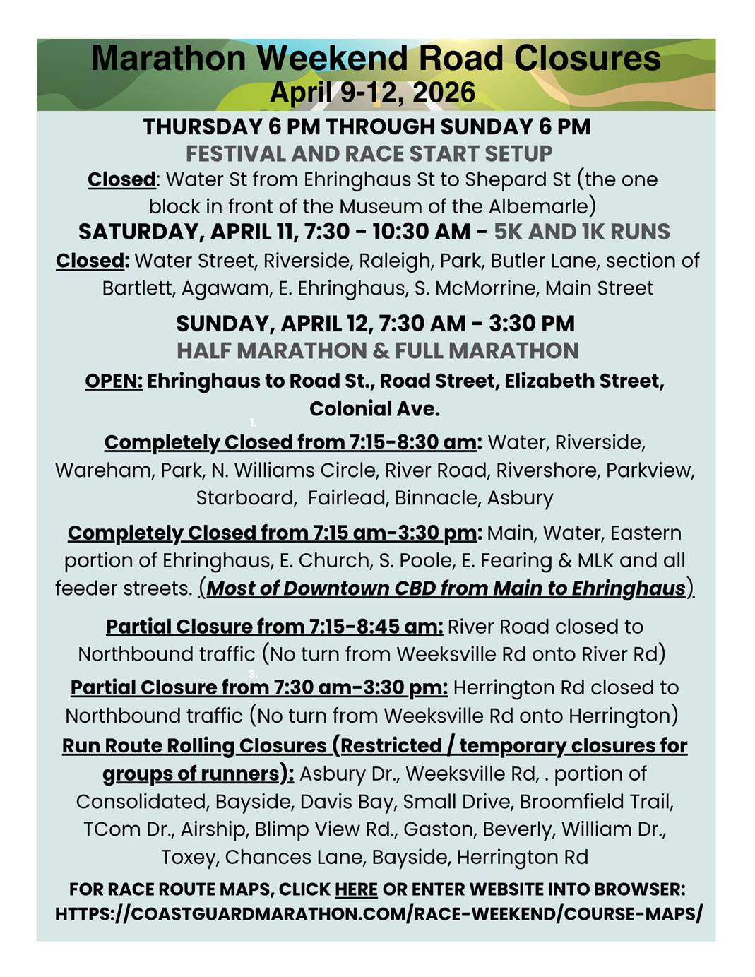
Visit Logged
  • Select Region
    • All Regions
    • VA to NC Line
    • North Carolina
    • South Carolina
    • Georgia
    • Eastern Florida
    • Western Florida
    • Florida Keys
    • Okeechobee Waterway
    • Northern Gulf
    • Bahamas
    • New York
    • Ohio
    • Pennsylvania
    • Washington
    • Puerto Rico
    • Minnesota
    • Maryland
    • Tennessee
    • NW Waters
    Order by:
    • Lace Up for Holiday Cheer at Camp Cale! Dec 20, Elizabeth City, NC


      Elizabeth City sits at the southern terminus of the Dismal Swamp Canal and has the well-earned reputation of being a transient-friendly town with free dockage for 72 hours.

      Lace Up for Holiday Cheer at Camp Cale!


      Lace Up for Some Holiday Fun at Camp Cale!

      Cocoa & Carols Fun Run

      Get into the holiday spirit with a festive 5K Walk/Run, carols, cocoa, and family fun at Camp Cale!

      Event Details

      Saturday, December 20th, 2025

      Race Start: 10:00 AM

      Registration Opens: 9:30 AM

      Location:

      James H. Cale Community Park at Camp Cale

      377 Camp Cale Rd., Hertford

      Race Information

      • 5K Walk/Run around the James H. Cale Community Park

      • Open to kids and adults

      • 1st, 2nd, and 3rd place prizes for both kids and adults

      Registration Fees

      • $30.00 Adults

      • $20.00 Kids (12 & under)

      Holiday Extras

      • Free hot chocolate while supplies last

      • A fun, festive atmosphere with cocoa and carols for the whole family

      Whether you’re running for a personal best, walking with family, or simply coming out to enjoy the holiday cheer, the Cocoa & Carols Fun Run is a great way to celebrate the season together. Bring your friends, bundle up, and make memories at Camp Cale as you run, sing, and sip cocoa our way into the holidays!

      Register Here!
       
       
      Elizabeth City Area Chamber of Commerce | 502 E. Ehringhaus St. | Elizabeth City, NC 27909 US
      Unsubscribe | Update Profile | Constant Contact Data Notice
      Constant Contact


      Be the first to comment!

    • Antarctic Ice Melt – Fred Pickhardt

      Fred Pickhardt’s Substack is free today. But if you enjoyed this post, you can tell Fred Pickhardt’s Substack that their writing is valuable by pledging a future subscription. You won’t be charged unless they enable payments.


      Forwarded this email? Subscribe here for more

      Antarctic Ice Melt

      Will this lead to massive sea level rise?


      READ IN APP


      Antarctica is 98% ice covered and contains 90 percent of Earth’s total ice volume. Melting ice is limited mainly to West Antarctica which is offset by ice mass gains over the remainder of Antarctica.


      The mass of the Antarctic ice sheet has changed over the last decades. Research based on observations from the Gravity Recovery and Climate Experiment (GRACE) satellites (2002-2025) and GRACE Follow-On (since 2018) indicates that between 2002 and 2025, Antarctica shed approximately 135 gigatons of ice per year, causing global sea level to rise by 0.4 millimeters per year. Since 2020, however, the Antarctic has seen little or no ice mass loss.


      At this rate, an additional 28 mm (1.1 inches) of sea level rise can be anticipated by 2100. If the Antarctic ice melt would triple between now and 2100 we should expect an additional 42 mm (1.7 inches) of sea level rise due to Antarctic melt.

      Ocean Weather Services

      Forensic Marine Weather Expert


      You’re currently a free subscriber to Fred Pickhardt’s Substack. For the full experience, upgrade your subscription.

      Upgrade to paid

       
      Like
       
      Comment
       
      Restack


      © 2025 Fred Pickhardt
      548 Market Street PMB 72296, San Francisco, CA 94104
      Unsubscribe

      Get the appStart writing


      Be the first to comment!

    • Temperature Whiplash This Week – SCDNR

       
      South Carolina Department of Natural Resources color logo and white text of agency name and State Climatology Office

      Weather Alert  –  December 12, 2025

      Temperature Whiplash

      As the title implies, we’re going to be on a roller coaster ride with our temperatures over the next week. We get milder at first, then blasted with the coldest air of the season so far Sunday night through Tuesday morning, then we gradually warm up through the rest of next week as a warmer weather pattern develops over this part of the country.

      Today, a weak storm system is passing north of us (with flurries as far south as Charlotte); we’ll remain dry as it and a trailing front cross the Palmetto State. Northern areas seeing clouds this morning will see the sun this afternoon.

      An air mass of Pacific origin will move in on Saturday, bringing sunshine and temperatures slightly above average. However, a second cold front now over the upper Midwest and northern Plains will approach.

      That next front will arrive in the Upstate around daybreak on Sunday and push through the rest of the state through the morning and early afternoon. This front will also bring limited moisture, only enough to trigger stray showers.

      This front will lead an arctic air mass into the Southeast. Often, cold air lags behind cold fronts moving through South Carolina by as much as a full day, but not this time. Highs for the day will occur as the front arrives, with temperatures falling during the midday and afternoon after a mild start in most places. Gusty north-northwesterly winds will make it feel even colder with wind chills dropping to the 20s and 30s over the northern part of the state. So, if it feels nice when you leave Sunday morning, take a jacket with you because it may not be so nice on the way home. The winds will be an annoyance for motorists and especially pickleball players. I’ve warned the members of my group to expect a cold, blustery comedy of errors when we play on Sunday afternoon!

      WPC forecast weather map showing the position of weather systems at 7 a.m. Sunday and precipitation areas for Sunday and Sunday night

      The forecast weather map for Sunday morning from the Weather Prediction Center shows their expected positions of weather features at 7 a.m. Sunday and precipitation areas for Sunday and Sunday night. Arctic air will arrive in the Upstate early in the day but during the midday and afternoon for the rest of South Carolina.

      The winds will diminish Sunday night, and we’ll wake up on Monday to the coldest temperatures we’ve experienced since last winter. It’ll be in the 15-20° range except at the coast, within shouting distance of the cold we saw back at Christmas of 2022. It’s potentially pipe-busting cold, so you’ll want to take time this weekend to make sure your home’s pipes are adequately insulated. If your plumbing is vulnerable to the cold, you’ll want to leave faucets dripping before you go to bed Sunday night.

      A plot of National Weather Service forecast low temperatures for Monday morning created by WeatherBELL

      The above map shows the forecast low temperatures on Monday morning across South Carolina from the National Weather Service.

      Image Source: WeatherBELL

      Temperatures will only recover to the 30s on Monday afternoon, with some low 40s in the Lowcountry. Another clear, frigid night follows for Monday night, though it won’t be quite as harsh with most areas seeing lows of 20-25° on Tuesday morning.

      Moderation begins Tuesday afternoon, which will be chilly but much more tolerable than Monday afternoon as most of the state gets to at least 50°.

      Temperatures take another step upwards to the upper 50s and lower 60s on Wednesday, then most places will get into the 60s on Thursday.

      Another cold front will be due here at the end of next week, but the exact timing is uncertain at this range. We’re also not sure how much moisture the front will have to work with; we probably will get some rain, but not a lot.

      I’m sure y’all are looking ahead to Christmas, and I am, too. A brief chilly spell should follow the late-week front for next weekend, before it turns warm again the following week. It’s too early to speculate on whether Christmas Day or a surrounding day will be wet or dry. However, above-average temperatures are likely, and the odds of a White Christmas across South Carolina this year are zero, rather than the usual infinitesimally small odds.

      If any part of the previous paragraph doesn’t work out, or you’re unhappy about warmth at Christmas, save it for The Airing of Grievances on the 23rd.


      Drought remains a problem in parts of the state, especially for some of the Lowcountry and the Central Savannah River Area.

      The U. S. Drought Monitor released on Thursday shows that about a third of South Carolina remains abnormally dry or in a drought.

      The drought conditions are likely to expand and worsen over the next couple of weeks, as our prospects for substantial rain are low during this period. We can definitely gripe about that next Tuesday.


      Frank Strait
      Severe Weather Liaison
      S.C. State Climate Office

      facebook
      instagram
      rss feed
      twitter
      youtube

      This email was sent to curtis.hoff@cruisersnet.net using GovDelivery Communications Cloud on behalf of: South Carolina DNR ·1000 Assembly Street · Columbia, SC 29201GovDelivery logo


      Be the first to comment!

    • Our Coast: On the ‘Old Mullet Road’ 1942 – Coastal Review

      Be the first to comment!

    • Found? Beaufort Inlet Channel Lighted Buoy 14 (LLNR 29310)


      On October 2, 2025, the Coast Guard issued:

      SAFETY/NC – BEAUFORT INLET/ATON/SEC SNC BNM 0337-25

      which stated the

      BEAUFORT INLET CHANNEL LIGHTED BUOY 14 (LLNR 29310) IS REPORTED MISSING.

      We recently received a report from Carlos in the Spanish town of Muxía that a number 14 buoy has been found there.   We can’t confirm it is the same buoy, but it seems like a possibility.  That would be a ~3,600 NM distance over approximately 70 days or averaging about 2 knots.  See the map image below for the route the buoy would have taken.

      Be the first to comment!

    • A brief reprieve isn’t lasting protection: Our fight continues – Coastal Review

      Be the first to comment!

    • Gloomy Through Saturday, A Little More Rain Monday – SCDNR

      The hurricane season for this year has ended.  Note that named storms this season have been below average. 

      South Carolina Department of Natural Resources color logo and white text of agency name and State Climatology Office

      Weather Alert  –  December 5, 2025

      Gloomy Through Saturday,
      A Little More Rain Monday

      A stationary front just to our south and east will keep us gray and mostly wet through Saturday. The heaviest rain will fall over the Lowcountry, while the Upstate will see the least.

      The good part of this is that parts of the state remain in a drought, so persistent chilly, wet weather is beneficial there. 

      The U. S. Drought Monitor for this week shows that much of SC remains abnormally dry with severe drought over parts of the CSRA and Lowcountry

      I’m sure some people are happy to see the rain (for example, I need to burn some wood debris that’s been accumulating in my backyard, and it’s been way too dry for that for months), but for most, it’s a bummer that Saturday looks gloomy.

      The rain comes in two waves as weak storms ride along the front to our south. The first is passing through this part of the country today, causing rain across the state. Rain will become confined to coastal areas tonight, then the next wave will affect areas mainly along and south of I-20 on Saturday. The rest of the state will remain dry Saturday, and parts of the Upstate might even see the sun pop out briefly at the end of the day. Temperatures will mainly sit in the 40s and lower 50s today, drop to the upper 30s and 40s tonight, then recover to the lower to middle 50s Saturday.

      Traveler’s Advisory: Those heading north into central and northern Virginia, Maryland, and Delaware through this evening will encounter snow; not a lot, but enough to cause slippery spots on the secondary roads and back roads.

      A loop of visible satellite imagery shows clouds along and north of a stationary front over the Gulf and western Atlantic

      A loop of visible satellite imagery shows clouds along and north of a stationary front stretching across the Gulf, Georgia, Florida, and the western Atlantic.

      Image Source: University of Wisconsin RealEarth

      We’ll see a better day on Sunday. Much of the state will see clouds and fog to start, but it looks partly sunny by the afternoon. Highs will mainly be in the 50s, and parts of the Lowcountry could touch 60.

      Another storm system will move in on Sunday night, causing light rain to break out again during the wee hours of Monday. A cold front will move in early on Monday as well, with air cold enough to turn the rain to snow up in the land of vinegar and tomato sauce. It’s conceivable that some wet snowflakes mix with the rain over areas north of I-20 here in South Carolina, but don’t expect anything significant. “Cold air chasing moisture” setups rarely lead to significant snow in this part of the country. Besides, there won’t be much precipitation falling on Monday, no matter what form it takes. Highs on Monday will range from the mid-40s north to the mid-50s south.

      Tuesday and Wednesday look tranquil under high pressure. That keeps us mainly sunny both days; Tuesday will be chilly with highs in the 40s and lower 50s, but Wednesday will be milder with highs mostly 55-60° (near average for early December). 

      A 1-2 punch of cold fronts will likely affect us Thursday into next Friday. However, neither front will be able to tap into substantial moisture, so we’ll see little or no rain during the period. Thursday looks a bit warmer than Wednesday with highs mainly in the upper 50s to middle 60s, but it will turn chilly again Friday with highs mainly in the 50s.

      Next weekend looks dry but cold. Highs will likely be in the 40s and 50s, with most of the state dropping below freezing at night. It’ll feel a lot like Christmas, and look that way, too. Brown grass, red and green pine trees, and bare hardwoods are how we normally roll at Christmas down here in South Carolina.


      Frank Strait
      Severe Weather Liaison
      S.C. State Climate Office

      facebook
      instagram
      rss feed
      twitter
      youtube
       
       GovDelivery logo


      Be the first to comment!

    • Elizabeth City: Lighted Boat Parade – TONIGHT


      Elizabeth City sits at the southern terminus of the Dismal Swamp Canal and has the well-earned reputation of being a transient-friendly town with free dockage for 72 hours.

      Be the first to comment!

    • Holiday lights are aglow ahead of annual Waterfowl Weekend – Coastal Review

      Be the first to comment!

    • It’s the most wonderful time of the year in Edenton! in Edenton! [Albemarle Sound, NC]


      Edenton, NC - the prettiest town in the South!

      A longtime CRUISERS NET SPONSOR, historic Edenton always has an exciting calendar of events and places to visit! Edenton is at the mouth of the Chowan River on the northwest shore of Albemarle Sound.​

      Click Here To View the North Carolina Cruisers Net Marina Directory Listing For Edenton Harbor City Docks

      Click Here To Open A Chart View Window Zoomed To the Location of Edenton Harbor City Docks

      Be the first to comment!

    • Elizabeth City: 1st Friday Art Walk – TOMORROW


      Elizabeth City sits at the southern terminus of the Dismal Swamp Canal and has the well-earned reputation of being a transient-friendly town with free dockage for 72 hours.

      Be the first to comment!

    • Last Chance: Set Sail Into the Holidays! Join the Albemarle Queen for Festive Cruises [Albemarle Sound, NC]


      Edenton, NC - the prettiest town in the South!

      A longtime CRUISERS NET SPONSOR, historic Edenton always has an exciting calendar of events and places to visit! Edenton is at the mouth of the Chowan River on the northwest shore of Albemarle Sound.​


      Holiday Magic on the Water — Aboard the Albemarle Queen!

      Experience Elizabeth City’s most unique holiday celebrations from the best seat in town: on the river. From parades to Santa sightings to festive dining, the Albemarle Queen is ready to make your season unforgettable!

      Holiday Cruise Lineup

      December 5 • 6:00 PM

      Lighted Boat Parade Dinner Cruise

      A front-row view of the parade plus a 4-course dinner.

      $75

      December 6 • 12:00 PM

      Lunch Cruise with Santa

      A family-friendly cruise with Santa on board and a pizza lunch.

      Kids $15 • Adults $25

      December 6 • 6:00 PM

      Holiday Magic Parade Dinner Cruise

      A second evening of festive lights with a 4-course dinner experience.

      $75

      December 7 • 12:30 PM

      Festive Holiday Lunch Cruise

      A cheerful midday cruise featuring a full holiday buffet.

      $55

      Reserve Your Spot

      Tickets, menus, and cruise details: AlbemarleQueen.com

      Questions or reservations: 844-IBX-BOAT

      Set sail, celebrate, and make this season shine aboard the Albemarle Queen.

       
      Connect with us!
      Facebook  Instagram  
       
      Elizabeth City Area Chamber of Commerce | 502 E. Ehringhaus St. | Elizabeth City, NC 27909 US

      Click Here To View the North Carolina Cruisers Net Marina Directory Listing For Edenton Harbor City Docks

      Click Here To Open A Chart View Window Zoomed To the Location of Edenton Harbor City Docks

      Be the first to comment!

    • Elizabeth City: Save the Date: Christmas Celebrations


      Elizabeth City sits at the southern terminus of the Dismal Swamp Canal and has the well-earned reputation of being a transient-friendly town with free dockage for 72 hours.

      Be the first to comment!

    • Kickoff to Christmas: Experience the Magic in Edenton! Dec 6 [Albemarle Sound, NC]


      Edenton, NC - the prettiest town in the South!

      A longtime CRUISERS NET SPONSOR, historic Edenton always has an exciting calendar of events and places to visit! Edenton is at the mouth of the Chowan River on the northwest shore of Albemarle Sound.​

      Click Here To View the North Carolina Cruisers Net Marina Directory Listing For Edenton Harbor City Docks

      Click Here To Open A Chart View Window Zoomed To the Location of Edenton Harbor City Docks

      Be the first to comment!

    • Tropics Done, Colder And Wetter Weather Pattern Ahead – SCDNR

      The hurricane season for this year ends on Sunday, and named storms this season have been below average.  

      South Carolina Department of Natural Resources color logo and white text of agency name and State Climatology Office

      Weather Alert  –  November 28, 2025

      Tropics Done

      The hurricane season for this year ends on Sunday, but it’s quiet across the Atlantic tropics, and there is no reasonable chance for any more storms to form over the next few weeks. So, I’m going to go ahead and call it: we did it … we survived another hurricane season!

      The season was below average in terms of the number of named storms (13, the average in recent decades is 14.1) and hurricanes (five, the average is 7.1), but above average in terms of major hurricanes (four, the average is 3.2) and seasonal ACE (accumulated cyclone energy, a measure of how much energy a season’s storms expend, there was a total of 132.6 units of ACE from this year’s storms and the average is 121.5).

      The best part of this year’s hurricane season is that we only had one landfalling storm in the United States. It was Tropical Storm Chantal, which made landfall here in South Carolina near Litchfield Beach on July 6. Impacts here in South Carolina were low-end, as the winds were not particularly strong and the storm’s rain was mostly welcome. However, Chantal’s rains caused severe flooding in parts of North Carolina and Virginia.

      A map from the National Hurricane Center showing the tracks of 2025's Atlantic storms.

      A map from the National Hurricane Center showing the tracks of 2025’s Atlantic storms.

      It will likely be months before we face another tropical threat, but it’s important to remain prepared. If it’s not something coming out of the tropics, it can be tornadoeswinter storms, and even earthquakes. So, check out those SCEMD webpages to be well-informed about disaster preparedness.


      A cold front that moved through on Wednesday night put an end to our warm weather, and it will be a while before any of us in the Palmetto State see it well into the 70s again. We started this morning with the coldest readings of the season so far, or nearly so, and we’re going to see temperatures remain mostly below average over the next week.

      No, it won’t be cold enough for snow. Not for the next week, anyway. We might see some opportunities for a winter storm later in December, but not right off the bat.

      A storm will pass by to our north over the weekend and pull a cold front into South Carolina on Sunday. Ahead of it, we remain cold but tranquil through today and Saturday with highs in the 40s north and 50s south. In between, much of the state will see subfreezing temperatures again tonight, with 20s widespread.

      Warmth surges into the Coastal Plain ahead of the next front, sending highs along and south of I-20 into the 60s (maybe 70° in the warmest spots), while the chilly air remains stuck over I-85 and north due to cold air damming; it will hold in the 40s and lower 50s there. Unfortunately, the front won’t have much moisture to work with, and we’ll only see isolated showers as it moves through. However, there could be a steadier drizzly or misty nuisance in the areas stuck in the cold air damming regime.

      The front will become stationary to our south, and another storm will ride along it through the Southeast on Monday night into Tuesday. The storm track will be along the Gulf Coast and then along the Carolina coast (you know, the sort that causes winter storms ’round these here parts, but it won’t be cold enough to cause any snow or ice here). It will be a close call for a little freezing rain northwest of I-85, where it will likely be in the middle to upper 30s when the rain moves in, so we’ll have to watch for changes in the coldest spots in our northwest. However, it’s likely to be a rain-only event for all of South Carolina. It will be a cold rain for most with highs only in the 40s north of I-20, with 60s confined to the coast.

      The good news is that we are likely to see widespread soaking rain of 1-2 inches across the state. There may even be rumbles of thunder along the Coastal Plain. Much of the state remains in a drought, which worsened compared to last week because it was mostly dry.  

      The latest U. S. Drought Monitor for South Carolina issued on Wednesday shows about a fourth of the state in a drought.

      The latest U. S. Drought Monitor for South Carolina issued on Wednesday
      shows about a fourth of the state in a drought.

      Wednesday through Friday next week looks dry and chilly. Highs will be mainly in the 50s on Wednesday, then it is likely to warm up somewhat to near-average 50s and low 60s for the end of the week. Another good chance of rain could arrive as early as next Friday night; next Saturday is likely to be wet, followed by a drier, colder Sunday.


      Frank Strait
      Severe Weather Liaison
      S.C. State Climate Office

      facebook
      instagram
      rss feed
      twitter
      youtube

      Be the first to comment!

    • Elizabeth City: Save the Date: Christmas Celebrations


      Elizabeth City sits at the southern terminus of the Dismal Swamp Canal and has the well-earned reputation of being a transient-friendly town with free dockage for 72 hours.

      Be the first to comment!

    • Happy (almost) Thanksgiving from Edenton! [Albemarle Sound, NC]


      Edenton, NC - the prettiest town in the South!

      A longtime CRUISERS NET SPONSOR, historic Edenton always has an exciting calendar of events and places to visit! Edenton is at the mouth of the Chowan River on the northwest shore of Albemarle Sound.​


      Click Here To View the North Carolina Cruisers Net Marina Directory Listing For Edenton Harbor City Docks

      Click Here To Open A Chart View Window Zoomed To the Location of Edenton Harbor City Docks

      Be the first to comment!

    • Elizabeth City: Save the Date: Christmas Celebrations


      Elizabeth City sits at the southern terminus of the Dismal Swamp Canal and has the well-earned reputation of being a transient-friendly town with free dockage for 72 hours.

      Be the first to comment!

    • This Thanksgiving, Let the Albemarle Queen Be Your Dining Room With a View Nov 27 [Albemarle Sound, NC]


      Edenton, NC - the prettiest town in the South!

      A longtime CRUISERS NET SPONSOR, historic Edenton always has an exciting calendar of events and places to visit! Edenton is at the mouth of the Chowan River on the northwest shore of Albemarle Sound.​

      Home | Accommodations Weddings | Events | Packages | RESERVATIONS

      Thanksgiving Dinner Banner
      Photo Credit Missy Mimlitsch and Yeopim Flowers Facebook

      Thanksgiving Dinner Aboard the Albemarle Queen

      Set Sail for a Coastal Thanksgiving to Remember

      Join us for an unforgettable Thanksgiving dining experience aboard the Albemarle Queen Paddleboat, featuring a five-course holiday menu created by the culinary team at The Table Restaurant.

      • November 27th
      • Boarding begins at 12:30 PM
      • Set sail at 1:00 PM
      • Return to port at 4:00 PM
      • Departure: Penelope Barker House Dock, Edenton, NC

      Savor an afternoon filled with the flavors of the season — beginning with our Gathering Boards from the Five Harbor Towns, followed by salmon and grits, honey-baked ham with cherry wine glaze, roasted turkey with all the trimmings, and a trio of decadent desserts.

      Experience breathtaking waterfront views, Southern hospitality, and the warmth of a truly coastal Thanksgiving celebration.

      Hotel guests – Book your stay online and add the Thanksgiving Package after selecting your room. (Need help? Just give us a call.)

      📞 Non-hotel guests Reservations required | 252-482-3641

      We hope to see you soon,

      Susan and the team at Inner Banks Inn

      REMEMBER TO ALWAYS BOOK DIRECT

      Get the best rates when you book on our website!  

      Be a savvy traveler and ALWAYS BOOK DIRECT.

      Check Availablity
      Email  Facebook  Instagram  YouTube
      Inner Banks Inn | 103 East Albemarle Street | Edenton, NC 27932 US
      Unsubscribe | Update Profile | Constant Contact Data Notice

      Click Here To View the North Carolina Cruisers Net Marina Directory Listing For Edenton Harbor City Docks

      Click Here To Open A Chart View Window Zoomed To the Location of Edenton Harbor City Docks

      Be the first to comment!

    • All the reasons why the 2025 hurricane season will be remembered as downright ‘weird’ – SunSentinel


      Be the first to comment!


    Social Media Auto Publish Powered By : XYZScripts.com