Hatteras Island Oyster Roast (Feb 15) Tickets on Sale!
![]()
Hatteras Island Oyster Roast Tickets on Sale!

Hatteras Island Oyster Roast
February 15, 2025
1 p.m. – 4 p.m.
![]()
Hatteras Island Oyster Roast Tickets on Sale!
Hatteras Island Oyster Roast
February 15, 2025
1 p.m. – 4 p.m.
Our thanks to Sarah Hill, Director of Dismal Swamp Welcome Center, for this notice.
Please see below the temporary closure of the Deep Creek Bridge starting Jan. 6th through March 21st to facilitate construction of the new Deep Creek bridge. The Deep Creek bridge will remain in the closed to navigation position during this time. Lake Drummond and the canal can still be accessed for paddling or boating excursions via the boat ramps along the canal or the South Mills Lock- which will continue to operate on normal schedule. Boaters will be unable to enter or exit the canal through the Deep Creek Bridge/Lock during this period.
Thanks,
Sarah
 Sector Virginia (757) 374-3408 MSIB 001-25
Deep Creek Bridge Deviation Mariners are advised of an infrastructure refurbishment project on the Deep Creek Bridge, mile 11.1 over the Dismal Swamp Canal, in Chesapeake, Virginia. The project will require the bridge to be maintained in the closed-to-navigation position from January 6, 2025, through March 21, 2025, to facilitate construction of the new bascule span of the new bridge. During this time period, visitors to Lake Drummond will be able to access the Dismal Swamp Canal via the South Mills Locks in South Mills, North Carolina or from the various boat ramps along the canal. Vessels transiting the Atlantic Intracoastal Waterway will need to use the Albemarle and Chesapeake Canal as an alternate route during this timeframe. Comments or concerns can be sent to the U.S. Coast Guard Sector Virginia Waterways Management Division via email at virginiawaterways@uscg.mil. # |
Click here for SEC VA MSIB 001-25 Deep Creek Bridge Deviation
Our thanks to Ted Arisaka for forwarding this notice from Dec 23 on FB and on Bob423.

Click Here To Open A Chart View Window, Zoomed To the Location of Alligator River Marina

A longtime CRUISERS NET SPONSOR, historic Edenton always has an exciting calendar of events and places to visit! Edenton is at the mouth of the Chowan River on the northwest shore of Albemarle Sound.
 |
| Happy New Year! 2024 was an incredible year in Edenton, and we hope you had the chance to join us sometime throughout the year. From hosting Stage 5 of the Bass Pro Tour to celebrating the 250th Anniversary of the Edenton Tea Party, Edenton’s calendar was packed full of events and activities for all ages! And 2025 is promising to be another incredible year in Edenton. Here are some of the highlights that we hope you’ll join us for during this next year.
This is only a taste of all of the exciting events we have planned during 2025. Check out our Calendar of Events as more events are added regularly. You can also check out our new 2025 Visitor Guide that includes an overview of special events, maps of Edenton and parking, and information on dining and lodging. It’s all the information you’ll need to plan the perfect trip to Edenton! As always, our Bed and Breakfasts are ready to welcome you to Edenton in 2025, and if you haven’t experienced their comfort, convenience, and charm, you’ll want to try their hospitality in this new year. We hope to see you in 2025! |
Erienne Mizell,
Tourism Director
| Visit our website! |
101 W King St, Edenton, North Carolina 27932
Click Here To Open A Chart View Window Zoomed To the Location of Edenton Harbor City Docks
ON DECEMBER 31ST, A SAFETY ZONE WILL BE IN EFFECT FOR A FIREWORKS DISPLAY ON THE BEAUFORT RIVER ADJACENT TO THE BEAUFORT WATERFRONT. THE SAFETY ZONE INCLUDES ALL WATERS WITHIN A 150-YARD RADIUS OF THE FIREWORKS BARGE FROM 8PM TO 10PM. NO VESSELS OR PERSONS MAY ENTER, TRANSIT THROUGH, ANCHOR WITHIN, OR REMAIN WITHIN THE DESIGNATED AREA UNLESS AUTHORIZED BY ON-SCENE OFFICIAL PATROL. |
1. NEW RIVER – CAPE FEAR RIVER DAYBEACON 19 (LLNR 39360 [34°30.4877N / 077°24.1591W, 34.508129 / -77.402651]) RPTD OFFSTATION.
Cruisers Net is proud to be a member of the Atlantic Intracoastal Waterway Association whose lobbying work is crucial to keeping the Waterway navigable and safe. Your membership dollars directly support their vital work. Please join and encourage your boating neighbors to do likewise, regardless of their homeport.
| ||||||||||||||||||||||||||||||||
| ||||||||||||||||||||||||||||||||
|
|
BOGUE SOUND – NEW RIVER BUOY 74 (LLNR 39305 [34°33.2068N / 077°21.2356W, 34.553446 / -77.353927]) IS REPORTED MISSING.

|
| Sarah Hill, TMP Director, Dismal Swamp Canal Welcome CenterChairperson, Camden County Tourism Development Authority 2356 US Hwy 17 North, South Mills, NC 27976
|
HATTERAS INLET – BARNEY SLOUGH CHANNEL LIGHTED BUOY 6 (LLNR 28722.3 [35°13.8092N / 075°47.6245W, 35.230153 / -75.793742]) HAS BEEN REPORTED OFF STATION. |
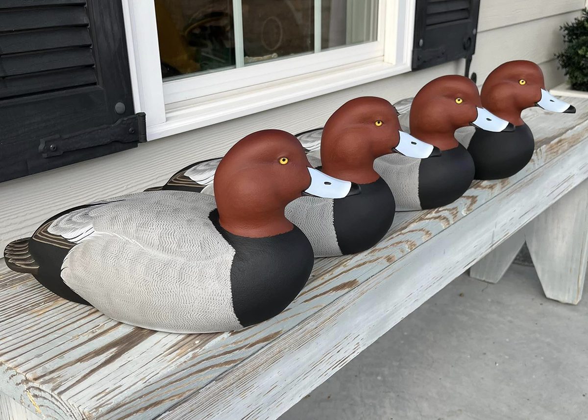
Decoys of redhead ducks created by Jason Michels. Photo: Contributed Read more at Coastal Review, coastalreview.org.
![]()
The Down East way: Harkers Island to celebrate waterfowl
Jennifer Allen, CoastalReview.org
CAPE FEAR RIVER – LITTLE RIVER DAYBEACON 63 (LLNR 40285 [33°54.8983N / 078°19.3806W, 33.914971 / -78.323010]), TRUB OFF STATION |
A longtime CRUISERS NET SPONSOR, historic Edenton always has an exciting calendar of events and places to visit! Edenton is at the mouth of the Chowan River on the northwest shore of Albemarle Sound.
 |
| Happy Thanksgiving to you and your family! During this holiday season, I am always reminded of the many reasons why I am thankful to live in Edenton. From its natural beauty to its charming downtown and welcoming community, Edenton offers many reasons to be thankful. If you’ve never visited Edenton, I’d like to invite you to spend part of the holiday season with us! You can book a comfortable and conveniently located room at one of our Bed and Breakfasts and experience all of the charm of Edenton during the holidays. I know that you’ll quickly see why we are so thankful to live in Edenton! I hope to see you soon.
|
101 W Water St, Edenton, North Carolina 27932
In the NC Cut, my family and I came upon what we thought was a Mickey Mouse balloon floating across the ICW. It was a black bear!


Special report: The state’s black bear population was in trouble 50 years ago, but research and conservation measures put in place in the decades since — with hunters’ “direct cooperation” — have enabled the species to recover, although not everyone is happy.
Click here for Today’s Coastal Review: Eastern NC’s black bears: How hunters helped save a species
11/26/2024 by Jennifer Allen

Every season in Washington, NC, A CRUISERS NET SPONSOR, brings something new and exciting. Enjoy local festivals, area concerts, or waterfront adventure.

A fishing skiff anchored at the North River Bridge in Otway, in Carteret County, is nearly silhouetted at dawn recently. Photo: Doug Waters, coastalreview.org.
Click here for Whales that use echolocation mistake plastic for prey: study
11/08/2024 by Jennifer Allen
CoastalReview,org

A kitesurfer harnesses the wind in waters near Teaches Hole Channel off Ocracoke Island in 2017. Photo: Mark Hibbs Read more at Coastal Review, coastalreview.org.
Click here for Ocracoke a beacon of maritime history, quiet attraction
CoastalReview.org
11/07/2024 by Eric Medlin
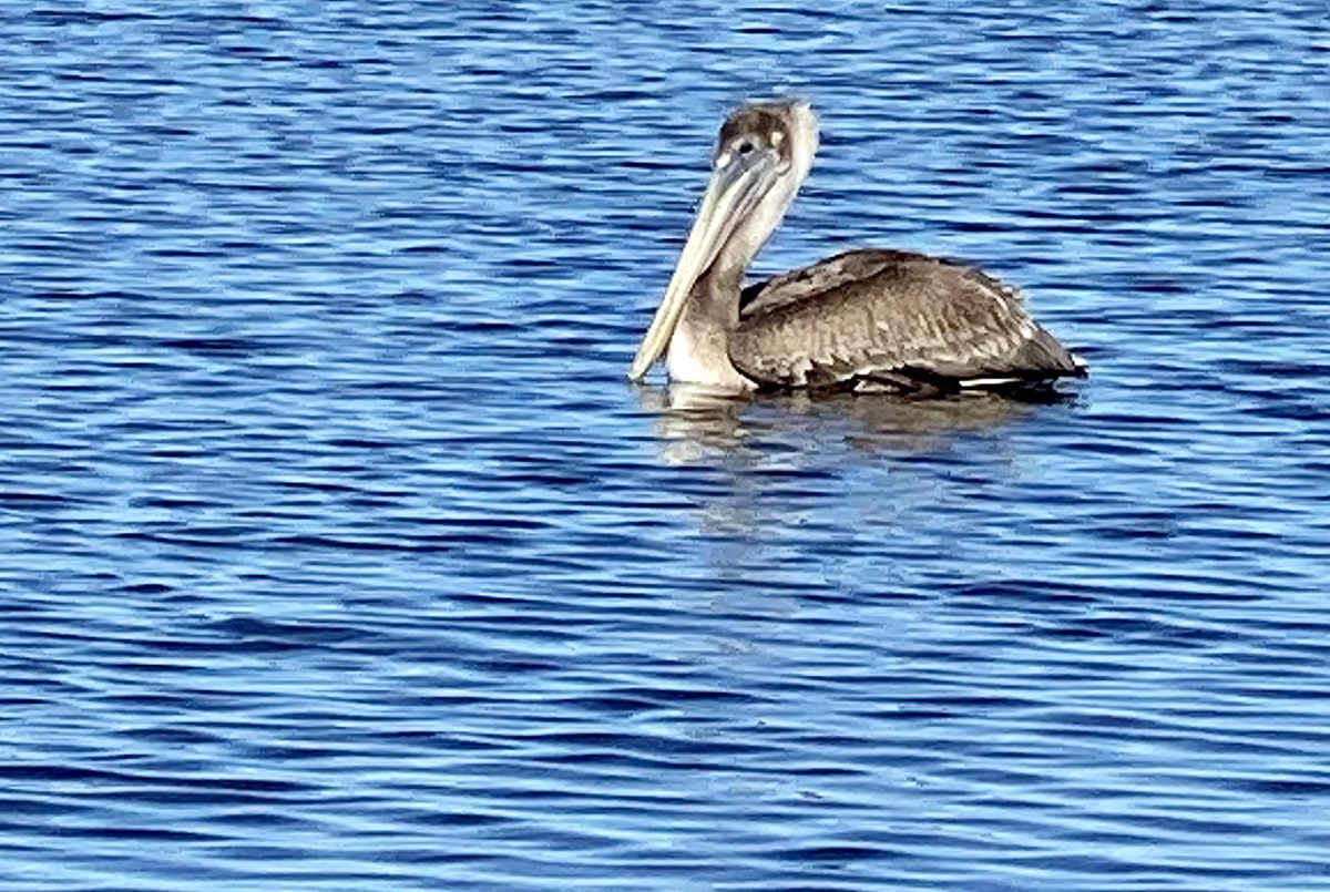
Behold the pelican, its beak can hold more than its belly can. Photo: Gordon Churchill Read more at Coastal Review, coastalreview.org.
Click here for Fishing is for the birds, and they can show you how, where
by Capt. Gordon Churchill
CoastalReview.org


Be the first to comment!