May OBX Park News: Meet Your Ranger, Adopt A Sea Turtle Nest, Pony Birthdays, and more!
|


…
[Message clipped] View entire message
 | ReplyForward |
|
…
[Message clipped] View entire message
| ReplyForward |
NC – NEW RIVER – CAMP LEJEUNE – NOTICE OF LIVE FIRING AND TRAINING EXERCISES
Marine Corps Installations East-Marine Corps Base Camp Lejeune, North Carolina, Live firing and training:
Mariners traveling in Atlantic Intracoastal Waterway through this area can expect a delays of about one to four hours during the below times. Range Control Boats, from Camp Lejeune, NC monitor Channel 16 VHF-FM and the working Channel 82 VHF-FM. Range Control can be reached at 910-451-3064 or 4449. Camp Lejune MILOPS 06 – 12 MAY 2024.
1. The restricted areas in the Atlantic Ocean east of the New River Inlet as shown on National Ocean Service Chart US5NC14M, will be closed to navigation up to 15 nm seaward because of firing exercises during the following periods:
8:00 A.M. – 5:00 P.M. 08 MAY 24 LIVE FIRE OPERATIONS (24 MEU, NSFS)
8:00 A.M. – 11:59 P.M. 09-10 MAY 24 LIVE FIRE OPERATIONS (10TH MAR-G-7)
Restricted areas in the new river, as shown on National Ocean Service chart US5NC14M, that will be closed to navigation because of stone bay rifle range firing exercises during the following periods:
Stone Creek Sector 12:01 a.m. to midnight daily
Stone Bay Sector 12:01 a.m. to midnight daily
West of the 77 (deg) 26 (min) Longitude line.
The restricted areas that may be closed to navigation because of firing exercises during the following periods:
Traps Bay Sector 12:01 a.m. to midnight daily
Courthouse Bay Sector 12:01 a.m. to midnight daily
Stone Bay Sector 12:01 a.m. to midnight daily
East of the 77 (deg) 26 (min) longitude line.
Grey Point sector 12:01 a.m. to midnight daily
Farnell Bay sector sunrise to sunset daily
Morgans Bay sector sunrise to sunset daily
Jacksonville sector sunrise to sunset daily
2. The target bombing area N1/BT-3 impact area in the Atlantic Ocean east of the new river inlet as shown on national ocean service chart US5NC14M, may be closed to navigation because of firing exercises during the following periods:
8:00 A.M. – 5:00 P.M. 08 MAY 24 LIVE FIRE OPERATIONS (24 MEU, NSFS)
8:00 A.M. – 11:59 P.M. 09-10 MAY 24 LIVE FIRE OPERATIONS (10TH MAR-G-7)
3. Atlantic Intracoastal Waterway, inland waters in the Browns Island Inlet area between Bear Creek and Onslow Beach, may be closed for firing exrcises during the following periods:
8:00 A.M. – 5:00 P.M. 08 MAY 24 LIVE FIRE OPERATIONS
(24 MEU, NSFS)
8:00 A.M. – 11:59 P.M. 09-10 MAY 24 LIVE FIRE OPERATIONS
(10TH MAR-G-7)
4. Due to unexploded ordnance on Browns Island and in the adjacent waterways and marsh areas, Browns Island is off limits to all unauthorized personnel. Vessels may transit the surrounding waters, however no vessel shall bottom fish or anchor.
5. Mariners traveling on the western side of the new river between Stone bay and Farnell Bay should be aware that there are numerous sign poles without working lights and are leaning or submerged as a result of Hurricane Florence and present hazards to navigation. These poles once had signs denoting areas of caution around the Stone bay rifle range and Verona Loop firing ranges.
5A. Signs are located along the stone bay, grey point and Farnell Bay sectors of the New River. Marine Corps Base Camp Lejeune is working to replace these signs.
6. Range control boats, MCIE-MCB CAMLEJ North Carolina monitor channel 16 VHF-FM (156.8 mhz) and the working channel 82 vhf-fm(161.725 mhz). Range Control can be reached by phone at 910-451-3064 or 4449.
With a closed vertical clearance of 14ft, the 2.8-mile bridge across the Alligator River has had lengthy closures to undergo repairs several times in recent years and, with a closure mandate in winds over 25 knots, Alligator River Bridge was almost always an “event” on ICW cruises, events that lead many southbound cruisers to be quests of Elizabeth City Mariners Wharf and guests of the Rose Buddies. See “The Legend of the Rose Buddies” Monument.

The Lindsay C. Warren Bridge over the Alligator River swings open for a pleasure craft. Photo: NCDOT
Click here for Firm to start driving test piles for new Alligator River bridge
CoasalReview.org
See also Federal grant to accelerate Alligator River bridge project, AICW MM 84
Click Here To Open A Chart View Window Zoomed To the Location of Alligator River Bridge
 OLD HOUSE CHANNEL DAYBEACON 10 (LLNR 28270 [35°44.1890N / 075°36.7301W, 35.736484 / -75.612168]) IS MISSING. |
|
…
[Message clipped] View entire message
| ReplyForward |

The Dismal Swamp Route departs the southbound Waterway at MM 7.2. Our thanks to Sarah Hill for this good news from Dismal Swamp Welcome Center, A CRUISERS NET SPONSOR! See original LNM: NAV ALERT
Good Monday Morning,
Per the Norfolk District, U.S. Army Corps of Engineers the historic Dismal Swamp Canal has reopened to boating traffic and resumed normal operations today, April 8th, 2024!
Lock Schedule : 8:30 & 11am and 1:30 & 3:30pm
We hope to see you soon & don’t forget to stop by and grab the new 2024 #DismalSwamp Boating sticker!
Many thanks,
Sarah

Albemarle Plantation Marina, a port on the Albemarle Loop and a CRUISERS NET SPONSOR, is located just off the AICW on the northern shores of Albemarle Sound on Yeopim River/Creek.
 | ||
| Your new Inner Banks Dream Home is closer than you think!Gorgeous, new move-in ready homes by Chesapeake Homes (with homesites of nearly an acre) means you won’t have to wait to enjoy Albemarle Plantation’s waterfront lifestyle. Life here is full of pristine, natural beauty, alongside some of the most With all your daily needs just minutes from the gates, and every amenity | ||
 | ||
 | ||
 | ||
 | ||
 | ||
 | ||
 | ||
| Discover Albemarle Plantation | Plan a Visit | Contact Us | ||
 | 128 Lakeside Drive, Hertford, NC 27944 • (800) 523-5958 • (252) 426-4653 The information contained herein is for informational purposes only and may change at any time without notice. AP Realty Company, LLC/Broker | |
Click Here To Open A Chart View Window, Zoomed To the Location of Albemarle Plantation Marina

Click here for SCHEDULED/CAMP LEJUNE MILOPS 01 – 07 APR 24/HAZ OPS/SEC NC BNM 0161-24

Cape Lookout National Seashore is a certified International Dark Sky Park. Photo: Alex Gu/Crystal Coast Stargazers
Click here for ‘Discover the Night’ during the Crystal Coast Star Party
CoastalReview.org
|
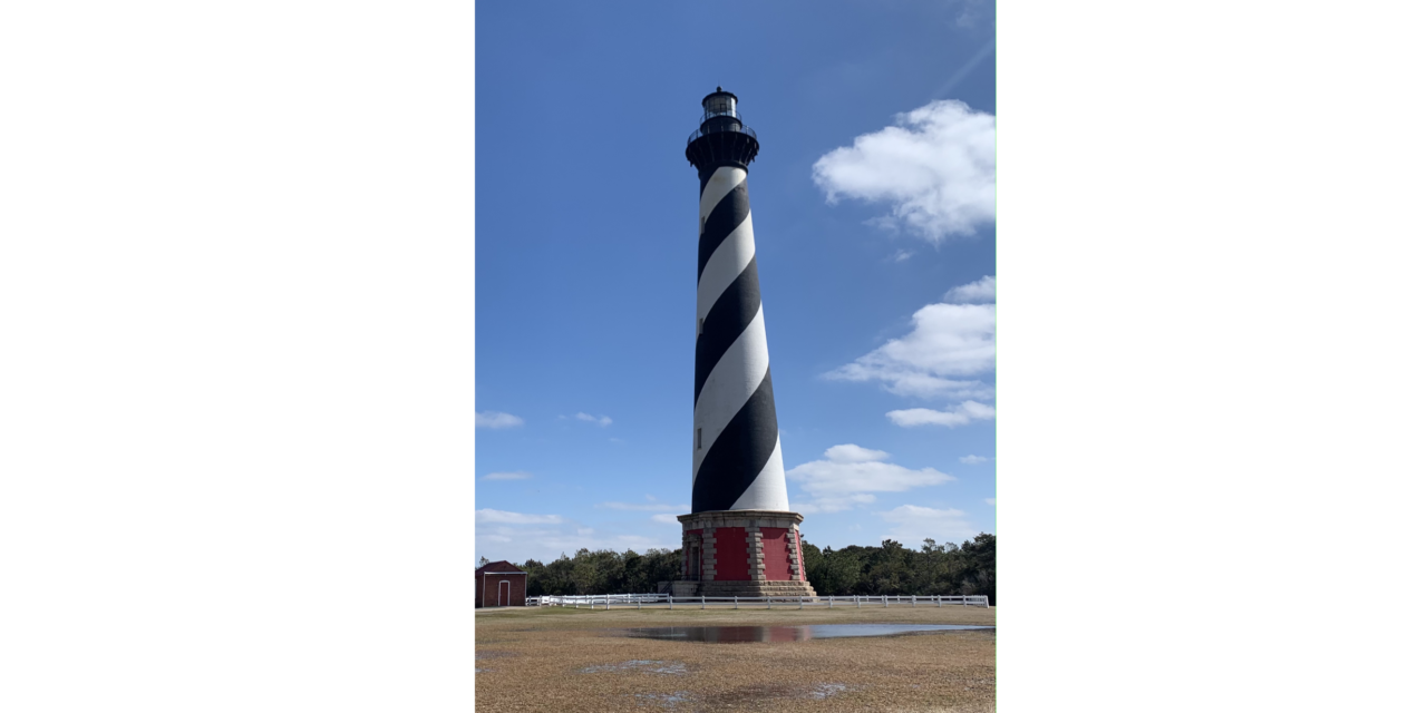
Click here for $19.2M Hatteras Lighthouse restoration gets underway
CoastalReview.org by Catherine Kozak
GREAT BRIDGE TO ALBEMARLE SOUND LIGHT 116 (LLNR 37615 [36°23.8837N / 075°57.2339W, 36.398061 / -75.953899]) DAMAGED AND MISSING BOTH DAYBOARDS.
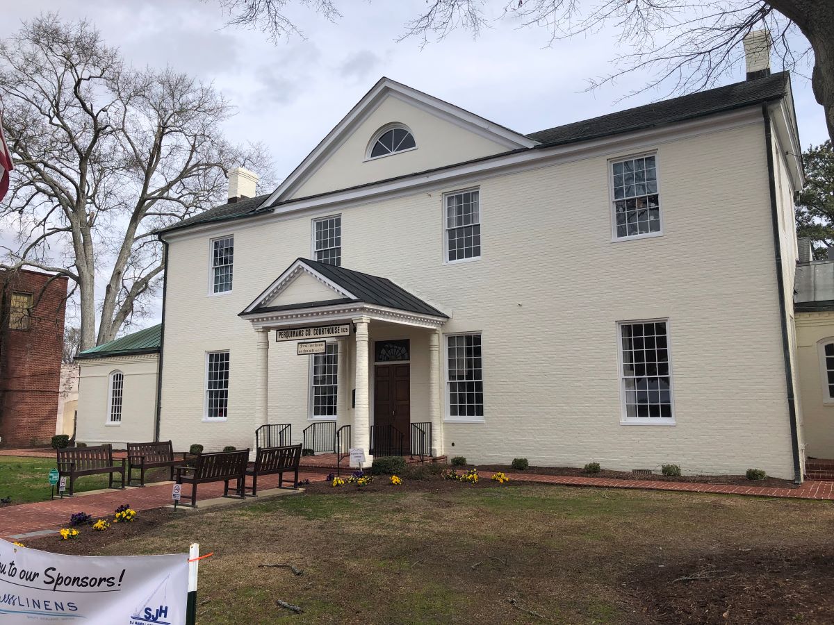
Perquimans County Courthouse in Hertford. Photo: Eric Medlin
Click here for Hertford’s quiet, rural setting, rich history add to its appeal
CoastalReview.org
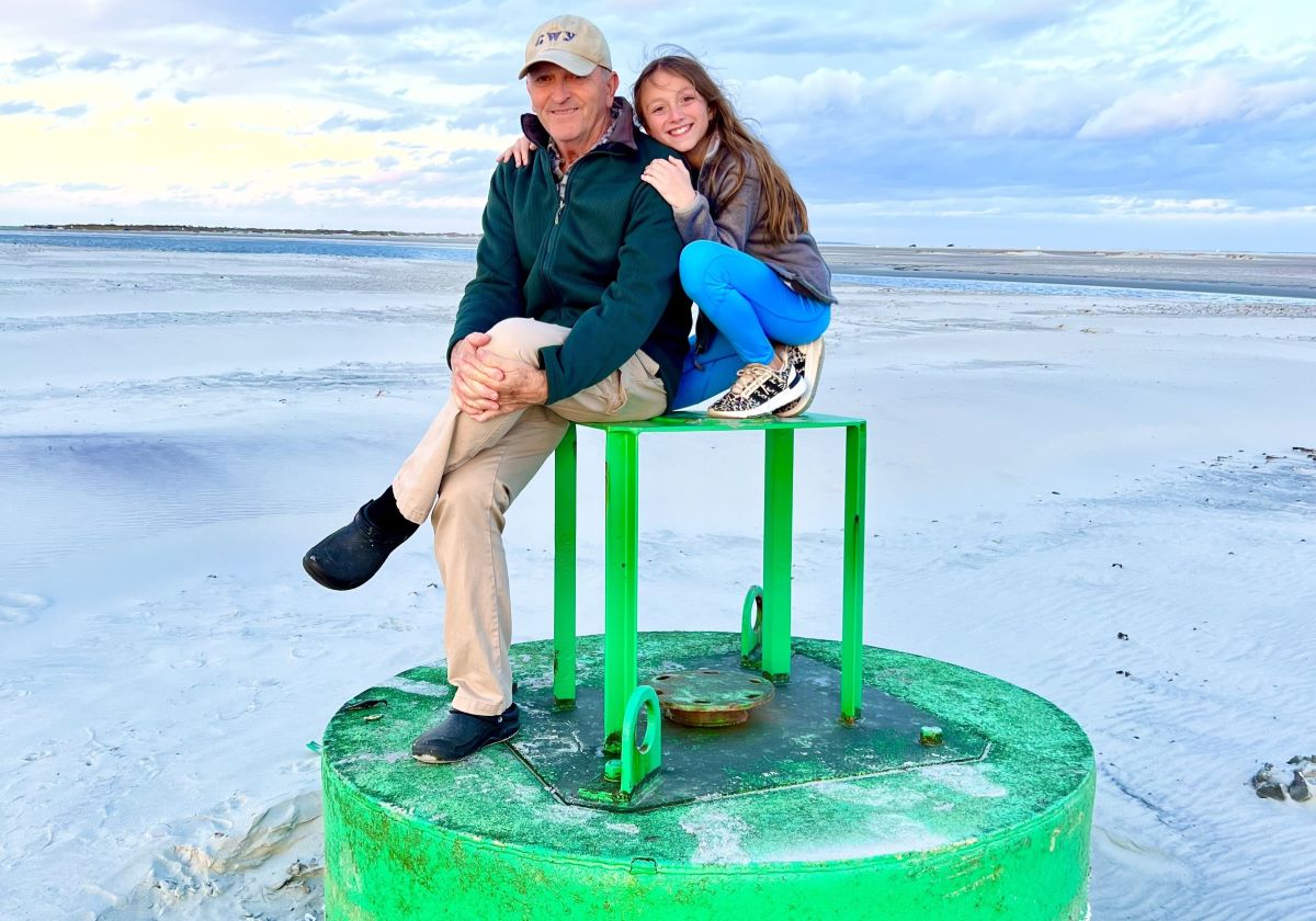
Alton Ballance poses with his daughter Emma Reese, 11. Photo: Contributed
Click here for Ballance to bring Ocracoke history to Core Sound’s present
CoastalReview.org

A loggerhead sea turtle swims just under the water’s surface. Photo: NOAA
Click here for DNA project links individual female loggerheads, nests
Trista Talton at CoastalReview.org
Click here for SCHEDULED/CAMP LEJUNE MILOPS 12-18 FEB 24/HAZ OPS/SEC NC BNM 0072-24
Click here for SCHEDULED/CAMP LEJUNE MILOPS 05-11 FEB 24/HAZ OPS/SEC NC BNM 0073-24
Our thanks to Belhaven Marina for this sunset photo from Belhaven, which sits on the northern shore of Pantego Creek south of the Alligator River – Pungo River Canal, and is A CRUISERS NET SPONSOR!

Click here for SAFETY/CAMP LEJUNE OPERATING AREAS/HAZ OPS/SEC NC BNM 0061-24
Elizabeth City sits at the southern terminus of the Dismal Swamp Canal and has the well-earned reputation of being a transient friendly town with free dockage for 72 hours.

Click here for Elizabeth City history traces back to early Colonial days
CoastalReview.org


Be the first to comment!