Visit Logged
  • Select Region
    • All Regions
    • VA to NC Line
    • North Carolina
    • South Carolina
    • Georgia
    • Eastern Florida
    • Western Florida
    • Florida Keys
    • Okeechobee Waterway
    • Northern Gulf
    • Bahamas
    • New York
    • Ohio
    • Pennsylvania
    • Washington
    • Puerto Rico
    • Minnesota
    • Maryland
    Order by:
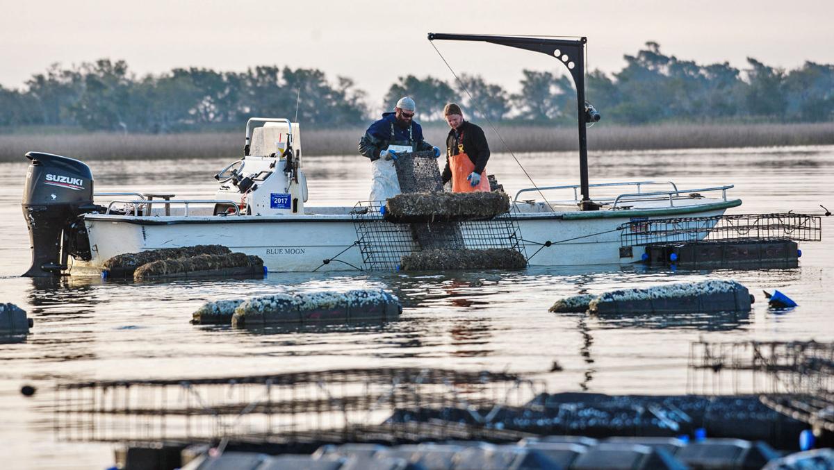
    • Report on Floating Oyster Frames in Steamboat Creek, off SC AICW MM 496


      Our thanks to Ted Arisaka for this report on a continuing debate over oyster farming and anchoring rights. See LNM: Oyster Beds to be Installed, Steamboat Creek and Oyster Farming Dispute Again in the News.


      About 6 months ago, I made a request to Kyle Ward of NOAA, to consider charting the mariculture area in Steamboat Creek (south of Charleston) as establish in the USCG Local Notice to Mariners District 7 Week 49 of 2020.

      Today, I received follow up from Kyle that they had indeed updated their ENC’s to show this area.
       
       
      I think this is a good development as state (DNR) and federal (NOAA, USCG) agencies work together to assist mariners avoid hazards to navigation as well as maintain compliance with any anchoring setbacks established by DNR.  Luckily in SC’s case, there is no setback as is the case in Georgia.
      Ted Arisaka


      Be the first to comment!

    • SCDNR Offering Courtesy Boat Inspections July 3 and 4, Various Locations

      To help prepare for the Fourth of July holiday weekend, SCDNR will be holding courtesy boat inspections across the state.


      —- NEWS RELEASE —-

      For Immediate Release
      dnr logo

      SCDNR courtesy boat inspections set for July 4th holiday

      SCDNR courtesy boat inspections

      Courtesy boat inspections will be hosted around the state on July 3 and 4th.


      COLUMBIA, S.C. (June 22, 2021) — In an effort to keep people and waterways safe during the Independence Day holiday, the South Carolina Department of Natural Resources (SCDNR) Law Enforcement Division will once again be conducting courtesy boat inspections at certain public boat landings around the state. The Fourth of July weekend is the year’s busiest weekend on state waters, and officers want to do everything possible to keep boaters out of harm’s way.

      SCDNR officers will perform quick but thorough inspections for required safety equipment and proper boat and motor registration. Those who are not in compliance with safety regulations or registration requirements will not be ticketed during the complimentary inspections. Instead, they will be given an opportunity to correct the problem before they launch their boat. SCDNR officers will also be available to answer questions and give boaters tips on how to stay safe on the water.

      Additional inspections will also be hosted later in July.

      To report boating violations such as reckless operation or an intoxicated boat operator, call the SCDNR toll-free, 24-hour hotline at 1-800-922-5431. For a copy of South Carolina’s boating regulations, to find out about local boating safety courses or to obtain a free float plan form, contact the SCDNR Boating Safety Office at 1-800-277-4301 or visit https://www.dnr.sc.gov/education/boated.html.

      Courtesy inspection sites for July 3 and July 4:

      July 3

      Anderson Co. — Riverfork Boat Ramp – Lake Hartwell; 2 p.m to 4 p.m.

      Beaufort Co. — Battery Creek Landing (Parris Island) – Battery Creek; 10 a.m. to noon 

      Charleston Co. — Wappoo Cut – ICW; 10 a.m. to noon 

      Charleston Co. — Buck Hall Landing – ICW; 10 a.m. to noon 

      Georgetown Co. — Carroll A. Campbell Landing – Sampit River; 10 a.m. to noon

      Horry Co. — New Peach Tree Landing – Waccamaw river; 10 a.m. to noon

      Kershaw Co. — Buck Hill Landing – Lake Wateree; 10 a.m. to noon 

      Laurens Co. — Riverfork Public Landing – Lake Greenwood; 10 a.m. to noon

      Lexington Co. — Lake Murray Dam – Lake Murray; 9 a.m. to noon 

      McCormick Co. — Dorn Landing – Lake Thurmond; 10 a.m. to noon 

      July 4

      Beaufort Co. — Lemon Island Landing (Edgar Glenn) – Chechesse River; 10 a.m. to noon 

      Berkeley Co. — Cypress Gardens Landing (Dunham Creek); 10 a.m. to noon 

      Charleston Co. — Remleys Point Landing – Wando River; 10 a.m. to noon 

      Greenwood Co. — Greenwood State Park – Lake Greenwood; 10 a.m. to noon 

      Horry Co. — Hwy 22 Bridge (Behind Bass Pro Shop) – ICW; 10 a.m. to noon 

      Marion Co. — Galivants Ferry Landing – Little Pee Dee; 10 a.m. to noon 

      Newberry Co. — Billy Dreher Island – Lake Murray; 9 a.m. to noon

      Oconee Co. — South Cove Park – Lake Keowee; 11 a.m. to 1 p.m.

      Pickens Co. — Twelve Mile Park – Lake Hartwell; 10 a.m. to noon

      Spartanburg Co. — Main Ramp – Lake Bowen; 11 a.m. to 1 p.m.

      York Co. — Ebenezer Park Landing – Lake Wylie; 10 a.m. to noon


      Also in July: Beaufort Water Festival — July 17

      Beaufort Co. — Battery Creek Landing (Parris Island) – Battery Creek; 10 a.m. to noon


      Media Contact:

      David Lucas

      SCDNR Public Information Coordinator

      843-610-0096

      LucasD@dnr.sc.gov

      South Carolina Department of Natural Resources – Rembert C. Dennis Building
      1000 Assembly Street, Columbia, SC 29201

      Be the first to comment!

    • SC Saltwater Fishing Licenses Increase in Price on July 1st

      Saltwater anglers fishing in South Carolina waters will begin paying more for their licenses beginning July 1, 2021.


      — NEWS RELEASE —

      For Immediate Release
      dnr logo

      Increases to state saltwater fishing license fees take effect July 1

      COLUMBIA, S.C. (June 24, 2021) — Saltwater anglers fishing in South Carolina waters will begin paying more for their licenses beginning July 1, 2021. The change will affect both resident and non-resident recreational anglers, and saltwater charter fishing vessels.

      The increase in the license fee passed by state lawmakers and signed into law by Gov. Henry McMaster earlier this month was one part of a comprehensive legislative package aimed at addressing overfishing of flounder that also included changes to size and bag limits, and the establishment of a new stocking program designed to help rebuild the state’s flounder population over time. 

      For South Carolina residents, the cost of an annual saltwater recreational fishing license will increase from $10 to $15, bringing South Carolina’s saltwater recreational license fees for residents in line with neighboring states (GA: $15; NC: $16). This represents the first increase in the state’s saltwater license fee in two decades. A complete list of new fees is outlined in the chart below.

      The new regulations also include a minimum size limit of 16 inches and allow a catch limit of 5 fish per person per day and no more than 10 fish per boat per day. Previously, the minimum size limit was 15 inches, and the catch limit was 10 fish per person per day and 20 fish per boat per day. The new harvest limits will also take effect July 1, 2021.

      Saltwater License Fees, Effective July 1

       Fee
      Resident – 14 Day $10 
      Resident – Annual $15 
      Resident – 3 Year $45 
      Nonresident – 1 Day $10 
      Nonresident – 7 Day $35 
      Nonresident – 14 Day No Longer Available 
      Nonresident – Annual $75 
      Nonresident – 3 Year No Longer Available 


      Charter Fishing Vessel License Fees, Effective July 1

       Fee 
      Resident – Six or fewer passengers $275 
      Resident – 6 to 49 passengers $450 
      Resident – 50+ Passengers $650 
      Nonresident – Six or fewer passengers $550  
      Nonresident – 6 to 49 passengers $900 
      Nonresident – 50+ Passengers $1,300 

      For additional information, contact:

      Erin Weeks at (843) 953-9845

      WeeksE@dnr.sc.gov

      South Carolina Department of Natural Resources – Rembert C. Dennis Building
      1000 Assembly Street, Columbia, SC 29201

      Be the first to comment!

    • A New Offering from Intracoastal Yacht Sales – Carolina Breeze

      Our focus is to assist boaters with the purchase or sale of their powerboats. All our yacht owners are trained and educated on the handling and systems of their new vessel as part of our service. We want to make sure your experience with us is easy by being thorough with your needs. Through aggressive internet marketing, publication ads, and our long term networks we also have the resources to get your yacht sold! Our experience allows us the understanding of the market place.

      Intracoastal Yacht Sales, a long-time CRUISERS NET SPONSOR, offers full service brokerage representation from three locations: Wrightsville Beach, NC, Little River, SC and Charleston, SC. You will want to see this exceptional cruising vessel! Click link below for full details,


      Carolina Breeze – 2002 44′ CARVER 444 Cockpit Motor Yacht
      Folly Beach South Carolina United States
      $224,900 USD

      Comments from Cruisers (1)

      1. Winston Fowler -  June 17, 2021 - 3:46 pm

        My wife and I purchased this Carver444 in 2002. Took delivery in Wilmington, NC in June. We cruised her until 2012 when family situations caused us to sell her . She has had only two owners in her 19 years… and two owners who cared very much for her. It is our hope that she finds a new owner who will enjoy her and care for her as the past two owners have. She will bring you many happy times and wonderful lifetime memories.
        Her first name was "WinSue" and now she is "Carolina Breeze"….
        Intracoastal Yachts knows this boat well and will be looking for her new owner. Bobby Gregory was involved when we sold her and has her in his care again.

        Reply to Winston
    • Storm Season Guide from Post and Courier, Charleston, SC

      Above-normal tropical activity, new ‘normals’ in the Atlantic and steering robotic surfboards into hurricanes.


      Sponsored by Lowcountry Foundation Repair


      Above-normal tropical activity, new ‘normals’ in the Atlantic and steering robotic surfboards into hurricanes


      Good morning, readers.

      Hurricane Wire is back and ready to bring you details of everything brewing in the Atlantic basin this season.

      Experts believe we could be in for another busy tropical season but nothing quite as bad as what was experienced in 2020. Last year was a record-breaking one with 30 named storms, 13 hurricanes and six major hurricanes. The National Oceanic and Atmospheric Administration does not believe this hurricane season will be as active as the last.

      In a 2021 Atlantic hurricane outlook released last month, NOAA’s acting administrator Ben Friedman said the agency projects a 70% probability of 13 to 20 named storms, six to 10 hurricanes and three to five major hurricanes.

      This may seem like quite a bit of projected tropical activity, but the baseline of “normal” changed in 2021 when meteorologists updated the 30-year period they use to determine average weather benchmarks. Moving forward, an average Atlantic hurricane season will have 14 named storms, seven hurricanes and three major hurricanes.

      So technically, NOAA’s predictions for this season are considered normal. Our Chloe Johnson reports that new weather benchmarks are reflecting a more active Atlantic season. However, scientists still disagree on whether climate change will lead to more hurricanes over the long term. Read more about that here.

      Researchers with the Tropical Meteorology Project at Colorado State University predict there will be 35 days in which a hurricane is active this season, and nine days in which a major hurricane is active. Their forecast for the 2021 hurricane season nearly mirrors the Project’s early prediction for the 2020 season. But last year exceeded expectations in many ways.

      Only time will tell what is in store for the Atlantic this year. So for now, let’s just stay vigilant.


      What’s brewing

      Conditions: Nothing is spinning in the Atlantic, but the National Hurricane Center has issued advisories on tropical depression Blanca located in the eastern Pacific. This is not a concern for South Carolina as the depression is several hundred miles south-southwest of the southern tip of the Baja California peninsula.

      Computer models: The Carolinas are expected to remain clear of threats for the foreseeable future.

      Outlook: Tropical cyclone formation is not expected in the Atlantic basin during the next five days. 

      What we’re talking about

      • Saildrone Inc. and the NOAA is hoping to get new insights into hurricane intensity by steering robotic surfboards into the storms, per Capital Weather Gang.
      • According to Eye on the Storm, the increase in named storms in the Atlantic could be driven by at least five factors, including human-caused global warming.
      • The NOAA predicts the 2021 hurricane season will include above-normal tropical activity, per The Post and Courier. 

      “New normal” for hurricane season keeps rising

      From 1981 to 2010, there were, on average, 12.1 named storms, 6.4 hurricanes and 2.7 major hurricanes of Category 3 or above each year.

      In the new period, 1991 to 2020, there were an average of 14.4 named storms, 7.2 hurricanes and 3.2 major hurricanes each year, according to data analyzed by Brian McNoldy, a senior researcher at the University of Miami.

      Hurricanes in history 

      On May 7, 2015, surf powered by a tropical depression lured a stand-up paddle boarder into the water on Isle of Palms. The storm would become Tropical Storm Ana, with wind gusts reaching 60 mph near Little River and Cherry Grove Beach. (File/Staff)

      Your questions, answered

      Have a question about how hurricanes work, how we cover them or any other storm-related questions? Reply to this email and we may feature your question in an upcoming newsletter!

      Like what we’re doing with Hurricane Wire? Forward this email to a friend!

      If you haven’t signed up for Hurricane Wire, you can sign up for this weekly email here

      Visit our Hurricane Wire Hub for more storm coverage throughout the week. 


      Hurricane Wire is a collaborative project produced by a team of Post and Courier journalists. Shamira McCray is its lead writer. Data visualizations are created by Bryan Brussee. “Hurricane in history” photos are curated by Matthew Fortner. The newsletter is produced and edited by Emily Daily and Matt Clough.


      Recommended for You

      Keep up with the latest climate change and environmental issues impacting the Lowcountry and the rest of South Carolina. In your inbox, every Monday.


      Be the first to comment!

    • SC Bill Restricts Anchoring in Same Spot to 14 days

      SC House Bill 3865 was passed and signed into law May 17 and will take effect July 1, 2021. Our thanks to Ted Arisaka for alerting us to this legislation.

      A local government may adopt an ordinance requiring a permit for a watercraft or floating structure to remain moored, anchored, or otherwise located in any one five-mile radius on public waters within its local jurisdiction for more than fourteen consecutive days. The cost of a permit required by a local government may not exceed fifteen dollars. An ordinance adopted pursuant to this subsection must not apply to watercraft:

      South Carolina House Bill 3865

      Be the first to comment!

    • SCDNR: Slow Down and Report Sightings of Manatees

      As manatees return to their summer haunts along the coast, South Carolina Department of Natural Resources (SCDNR) and U.S. Fish and Wildlife Service (USFWS) biologists are reminding residents and visitors to boat carefully and report sightings of these gentle giants online.


      — NEWS RELEASE —

      For Immediate Release
      dnr logo

      Boat carefully and report sightings as manatees return to South Carolina

      manatee

      This manatee wears a satellite tag to help researchers track its movements (Photo: Clearwater Marine Aquarium Research Institute)

      CHARLESTON COUNTY, S.C. (May 24, 2021) – As manatees return to their summer haunts along the coast, South Carolina Department of Natural Resources (SCDNR) and U.S. Fish and Wildlife Service (USFWS) biologists are reminding residents and visitors to boat carefully and report sightings of these gentle giants online.

      Manatees are large marine mammals that reach around 10 feet in length and weigh up to a ton. They’re warm weather visitors in South Carolina, typically arriving in May and leaving by November when water temperatures drop below 68 degrees Fahrenheit. Because of the difficulty of counting them in murky waters, South Carolina’s manatee population is currently unknown – but it’s a small fraction of the United States’ estimated 6,600 animals, most of which live in Florida. Due to federal and state protections, it’s illegal to hunt, play with or harass manatees, which includes touching, providing water to or attempting to feed them.

      Biologists with the Clearwater Marine Aquarium Research Institute have been tagging rescued manatees in an effort to study their migration habits outside the state of Florida. A number of tagged animals have already made their way to our waters, including ones bearing satellite transmitters. Tagged manatees wear a “belt” around the base of their tails and trail a floating satellite transmitter that collects and sends information about the animal’s location (see photo). The tags are harmless to the animal and designed to break free in case of entanglement. Officials ask that members of the public do not pull or tamper with these tags – they’re providing valuable information to help wildlife researchers better understand and protect these mammals.

      There are several ways members of the public can help South Carolina’s manatees. SCDNR staff encourage anyone to report sightings and provide photographs (if possible) of live manatees online. Photographs of scars on manatees’ backs and tails are particularly useful, because they can often be used to identify previously known individuals. However, manatees should never be approached to obtain pictures.

      Injured or dead manatees should be reported immediately to the SCDNR wildlife hotline at 1-800-922-5431. If a boat accidentally collides with a manatee, SCDNR biologists ask that the boater stand by and immediately contact SCDNR or the U.S. Coast Guard on VHF Channel 16. Doing so provides biologists the best chance to help the animal and gather valuable scientific data.

      In addition to reporting sightings, coastal residents and visitors can help manatees by staying alert while on the water and avoiding harmful interactions with the animals.

      “Feeding and watering manatees encourages the animals to spend time at docks and marinas, making them more susceptible to boat strikes. In addition to being one of the main causes of mortality for manatees, it is also illegal,” said USFWS biologist Melanie Olds. The manatee is protected under federal law by the Marine Mammal Protection Act of 1972 and by the Endangered Species Act of 1973, which makes it illegal to harass, hunt, capture or kill any marine mammal. Conviction at the federal level is punishable by fine of up to $50,000 and/or one year in prison.   

      Collisions between boaters and manatees are more likely to occur in shallow waters, particularly around docks and at the edge of marshes where manatees feed. Staying alert, following safe boating practices and maintaining lower speeds in these areas can reduce the risk of a collision. Boaters should also watch for manatee backs, tails, snouts and “footprints” – a series of round swirls on the surface caused by a swimming manatee’s tail.

      For 44 years, the Florida manatee was protected as “endangered” under the federal Endangered Species Act. In March of 2017, as a result of increasing numbers and improving habitat, USFWS reclassified their status as “threatened.” Manatees are still protected under federal and South Carolina law and face a number of threats on their continued path to recovery. The greatest dangers to the species include boat strikes, entanglement in fishing gear and harmful algal blooms known as red tides.

      manatee2

      This map shows an example of the location data collected by the Clearwater Marine Aquarium Research Institute from satellite-tagged manatees.

      Tips for Being Manatee Friendly in South Carolina:

      • Dock owners should never feed manatees or give them fresh water. This could teach the animals to approach docks, putting them at greater risk of a boat strike, and it is illegal.
      • Never pursue, harass or play with manatees. It is bad for the manatees and is illegal.
      • Boaters should look around for manatees before cranking your boat’s motor and watch for large swirls in the water, or “footprints,” that may be caused by manatees diving away from the boat.
      • Heed “slow speed,” “no wake” and manatee warning signs, especially around docks. Use caution when navigating in shallow water and along the edge of a marsh.  Manatees cannot dive away from boats in these areas.
      • Wear polarized sunglasses to reduce glare, making it easier to spot manatees below the surface.

      For additional information, contact:

      Erin Weeks at (843) 953-9845

      WeeksE@dnr.sc.gov

      South Carolina Department of Natural Resources – Rembert C. Dennis Building
      1000 Assembly Street, Columbia, SC 29201

      Be the first to comment!

    • SCDNR Offering Courtesy Boat Inspections May 29-31, Various Locations

      To help prepare for the Memorial Day holiday weekend, SCDNR will be holding courtesy boat inspections across the state.


      —- NEWS RELEASE —-

      For Immediate Release
      dnr logo


      SCDNR to hold courtesy boat inspections during Memorial Day holiday weekend


      COLUMBIA, S.C. (May 24, 2021) — To help prepare for the Memorial Day holiday weekend, the South Carolina Department of Natural Resources (SCDNR) Law Enforcement Division will be holding courtesy boat inspections at public boat landings across the state.

      SCDNR officers will perform a quick, but thorough, inspection of your boat to make sure you have the required safety equipment and proper boat and motor registration for your watercraft before you launch. These inspections are completely voluntary and are not required before launching.

      Boaters who take advantage of the inspection and are found to not be in compliance with safety regulations or registration requirements  will not be ticketed during the complimentary inspections. Instead, boaters will be given an opportunity to correct the problem before they launch their boat.

      SCDNR officers will also be available to answer questions and give boaters tips on how to stay safe on the water.

      DateLandingTimeCounty
      5/29Johnnie Causey Landing – ICW10 a.m. to noon Horry 
      5/29 Lake Murray Dam10 a.m. to noonLexington
       5/30 
       
      River Forks Boat Ramp – Lake Hartwell
       
      2 to 4 p.m.Anderson
       5/30 
       
      Battery Creek Landing – Battery Creek
       
      10 a.m. to noonBeaufort
      5/30
       
      Easterling Landing – Lake Robinson
       
      11 a.m. to 1 p.m.Darlington
      5/30
       
      Dreher Island Landing
       
      10 a.m. to noonLexington
      5/30
       
      Ebenezer Park – Lake Wylie
       
      12 to 2 p.m.York
      5/31
       
      Wapoo Cut Landing – ICW
       
      10 a.m. to noon Charleston 
      5/31
       
      Alex Harvin Landing – Lake Marion
       
      10 a.m. to noonClarendon
      5/31
       
       Greenwood State Park – Lake Greenwood 
       
      10 a.m. to noonGreenwood
      5/31
       
      Clearwater Cove – Lake Wateree
       
      12 to 2 p.m.Kershaw
      5/31
       
      Dorn Landing – Lake Thurmond
       
      10 a.m. to noonMcCormick
      5/31
       
      Twelve Mile Landing – Lake Hartwell
       
      10 a.m. to noonPickens
      South Carolina Department of Natural Resources – Rembert C. Dennis Building
      1000 Assembly Street, Columbia, SC 29201

      Be the first to comment!

    • SC Oyster Farming Permit Conflicts

      Our thanks to Ted Arisaka for these reports from SC journalists. See Oyster Farming Dispute.


      As you know, in Georgia, the “approved” shellfish harvest areas greatly impinged upon anchorages. Here is an investigative report on alleged conflict of interest in neighboring South Carolina.
      Ted Arisaka

      Shell game: Conflict, secrecy cloud battle over SC oyster farming permit
      Charleston Post Courier

      Uncovered: Conflict, secrecy cloud battle over SC oyster farming permit
      Index-Journal

      Be the first to comment!

    • Wounded Nature Fundraiser – We need YOUR help!

      As much as we might wish to participate, we can’t always put on our gloves and boots and wade into the fray. So here is your opportunity to contribute to the efforts of this fine volunteer group to clean up Charleston’s waterways on our behalf. Please give what you can!


      Wounded Nature – Working Veterans needs your help!  We clean and rehabilitate critical coastal areas that others cannot reach: Trash/Debris, Treated Wood/Tires, Abandoned/Derelict Vessels. 

      We make a Real Coastal Difference but doing this requires the right equipment.  2021 is our year to grow and upgrade our 20+ year old boats with two proper workboats. With the right equipment, we will increase our capacity and reach to do more by going after the really tough to get stuff – big treated wood (dock pilings/telephone poles), buried tires, and all the stuff we’ve been seeing but unable to remove to date.

      Please consider donating.  We have three levels of “perks” so check out the link.  https://igg.me/at/WoundedNature/

      Sharing this fundraiser with your network is just as impactful so please SHARE away to help Wounded Nature – Working Veterans continue to MAKE A REAL COASTAL DIFFERENCE in 2021 and for years to come!

      Thank you all for your support!

      Whit Jones

      Wounded Nature – Working Veterans

      www.woundednature.org

      843-737-1088

      Be the first to comment!

    • USCG: Sector Charleston Prepares for Upcoming Hurricane Season

      See also Hurricane and Severe Weather Preparation.


      SECTOR CHARLESTON

      UPCOMING 2021 ATLANTIC HURRICANE SEASON

      The Atlantic Hurricane Season will begin June 1, 2021 and will run through November 30, 2021. During this timeframe, the assigned port condition (PORTCON) will remain PORTCON IV and the port status will remain OPEN for all ports and waterways within the Sector Charleston Captain of the Port Zone. These waters are identified in 33 CFR 3.35-15 and lie between the intersection of the North Carolina – South Carolina boarder and the northern bank of the Savannah River.

      In the event of forecasted tropical storm force winds (sustained winds of 34 kts/39 mph or greater) from a tropical cyclone, the Sector Charleston Captain of the Port (COTP) will coordinate with the Heavy Weather Advisory Group (HWAG) to evaluate port preparation and changes in port condition.

      The HWAG consists of maritime transportation system professionals local to the Sector Charleston Captain of the Port Zones, providing input on local operations and coordination for overall port well-being in response to severe weather events.

      The COTP will announce changes to port conditions via a Marine Safety Information Bulletin (MSIB) and a Broadcast Notice to Mariners when forecasted tropical storm force winds (sustained winds of 34 kts/39 mph or greater) from a tropical cyclone threaten South Carolina. These port conditions are as follows:

      Forecasted Hours Prior to Tropical Storm  Force WindsPort ConditionMeasures in Effect
      1 DEC – 31 MAYVGeneral. Port status is OPEN.
      1 JUN – 30 NOVIVHurricane seasonal alert. Industry to review heavy weather plans. Port status is OPEN.
      72WHISKEYThe COTP will assess lay-up and mooring plans, meet with stakeholders, and conduct port assessments. Port status is OPEN.
      48X-RAYThe COTP will finalize review of lay-up and mooring plans, hold further meetings with stakeholders, and continue port assessments. Port Status is OPEN.
      24YANKEEThe COTP may restrict vessel movements, including stopping inbound vessel traffic, and cargo operations. Port status is OPEN with RESTRICTIONS.
      12ZULUThe COTP may restrict all vessel movements, including stopping inbound and outbound vessel traffic, and cargo operations. Port status is CLOSED.
      AFTER

      STORM PASSAGE

      OPEN or OPEN with RESTRICTIONSPrior to authorizing vessel movements and cargo operations, the COTP will conduct a risk analysis based on actual weather observed and port assessments, which may include verifications of aids to navigation, channel hazards, waterfront facility damage, and vessel accountability.

      Very Respectfully,

      LT Chad Ray

      USCG Sector Charleston

      Waterways Management Div., Chief

      (843) 323-7761


      All vessels, waterfront facilities, and marinas should review their heavy weather plans now. Please take into account that drawbridges may not open for vessel traffic when sustained wind speeds reach 25 mph or during land evacuations. Vessels or oceangoing barges greater than 500 gross tons that are unable to go to sea are required to submit heavy weather plans to the COTP. The request form can be obtained from Sector Charleston’s HOMEPORT internal site at https://homeport.uscg.mil/port-directory/charleston. All requests should be submitted to D07-PF-SECTORCHASN-WWM@uscg.mil. The COTP will carefully evaluate vessels requesting to remain in port. Submission alone of a Remain in Port Request does not grant approval from the COTP.


      Currently, and running to May 31, 2021, the threat of severe weather is decreased. PORTCON V with a port status of OPEN remains in effect. This, however, does not prevent the COTP from changing port conditions in the event of forecasted severe weather.

      For HWAG or waterway specific questions, please contact (843) 323-7761. For facility and foreign vessel specific questions, please contact (843) 740-3186. For domestic vessel specific questions, please contact (843) 754-2076. For Coast Guard related emergencies, please contact Sector Charleston Command Center at (843) 740-7050.


      This MSIB can be viewed at https://homeport.uscg.mil/port-directory/charleston.

      Attachments area

      Be the first to comment!

    • Tall Ship Eagle to Visit Charleston, Mar 12-14, 2021, Cruise Ship Terminal, Charleston, SC

      At 90 meters (295 feet) in length, Eagle is the largest tall ship flying the stars and stripes and the only active square-rigger in United States government service.


      CHARLESTON, S.C. — The Coast Guard tall ship Eagle, “America’s tall ship,” is scheduled to arrive Friday at the Charleston Cruise Ship Terminal.

      WHO: The Coast Guard tall ship Eagle

      WHAT: The Barque Eagle is scheduled to arrive in Charleston. Free pier-side exhibits and discussion with officer candidates and members of Eagle’s crew.

      WHEN: Friday, March 12 through Sunday, March 14

      WHERECharleston Cruise Ship Terminal at 196 Concord St., Charleston, SC 29401

      HOW: During this time, there will be opportunities to enjoy free pier-side exhibits and discussions with officer candidates and members of Eagle’s crew. Due to COVID safety protocols, public tours onboard the ship are not available at this time.

      Barque Eagle will be open for free public tours on the following dates and times:

      • Friday, March 12
        • 1 p.m. – 4 p.m.
      • Saturday, March 13
        • 9 a.m. – 4 p.m.
      • Sunday, March 14
        • 9 a.m. – 4 p.m.

      At 90 meters (295 feet) in length, Eagle is the largest tall ship flying the stars and stripes and the only active square-rigger in United States government service. Constructed in 1936 by the Blohm and Voss Shipyard in Hamburg, Germany, and originally commissioned as the Horst Wessel by the German Navy, Eagle was a war reparation for the United States following World War II. Eagle is a three-masted barque with more than 6,797 square meters (22,300 square feet) of sail and 9.7 kilometers (6 miles) of rigging, Eagle has served as a classroom at sea to future Coast Guard officers since 1946, offering an at-sea leadership and professional development experience as part of the Coast Guard Academy and Officer Candidate School curriculum.

      Additional information about the Eagle can be found here. The Eagle’s design dimensions can be found here.

      The Eagle’s navigator, Lt. Will Singletary, is a native of Charleston and a 2013 graduate of The Citadel.

      For a continuous stream of information about Coast Guard Tall Ship Eagle, including port cities, tour schedules, current events, as well as cadet and active duty crewmember photographs, follow the “United States Coast Guard Barque EAGLE” Facebook page.

      For more breaking news follow us on Twitter and Facebook.

      -USCG-

      1 Facebook Likes, 1 Facebook Reactions

      Be the first to comment!

    • Oyster Farming Dispute Again in the News

      In the recent past, there have been local objections from boaters about these floating oyster beds and their implementation.  Many boaters consider the floating beds to be a danger to navigation and a reduction of anchoring space. See Oyster Beds.


      Lowcountry Oyster Co. operates one of South Carolina’s five floating-cage oyster farms in the region. Growers say it’s the most reliable way to farm oysters, but some boaters and waterfront property owners are opposed to them. File/Provided


      Fight over floating oyster farms erupts anew as SC bill could pause summer harvest.
      Post and Courier

      Be the first to comment!

    • Charleston Race Week Webinar, March 8, 4PM

      On the fence about Charleston Race Week or the Melges 24 Gold Cup? Are you attending and want to know what to expect and how to stay safe? Join Charleston Race Week and Quantum Sails Monday for a webinar with Regatta Organizer Randy Draftz and Quantum Pro Scott Nixon to get the lowdown and ask your questions. Race Week is April 8-11, 2021, see link below.

       
      On the fence about Charleston Race Week or the Melges 24 Gold Cup? Are you attending and want to know what to expect and how to stay safe?

      Join Charleston Race Week and Quantum Sails Monday, March 8 at 4 PM ET / 1 PM PT for a webinar with Regatta Organizer Randy Draftz and Quantum Pro Scott Nixon to get the lowdown and ask your questions.

      REGISTER NOW
      Still need to register for the Charleston Race Week regatta? CLICK HERE >>
      Stay tuned for more details on the Melges 24 Gold Cup, formerly the Worlds!
       
      KNOWLEDGE IS
      POWER
      Regatta Organizer, Randy Draftz, has spent the last year in close contact with local health officials and the local university to stay on top of the latest info and best practices to ensure when 2021’s Charleston Race Week rolled around, he would be able to give sailors around the country a much needed safe, fun, and exciting regatta. 
      SAFETY & SOCIAL PLAN DETAILS

      As you can image, this event won’t look like Charleston Race Weeks of the past, but that doesn’t mean there won’t be expert knowledge, epic racing, and fun to be had. Randy Draftz and Scott Nixon will discuss the current plans for the regatta including the social scene, debriefs and dock talks, even weather and what to expect in general.

      TIPS FOR A SAFE REAGATTA 

      Quantum’s Scott Nixon and his team have slowly begun campaigning this winter. He will talk through how they and other teams have been able to hit the water safely and share some tips that they’ve learned along the way.

      Q&A

      There will definitely be questions and Randy and Scott are ready for them. They want to make sure you’re comfortable and confident to head to Charleston and enjoy some time on the racecourse.

       
      REGISTER NOW
       
      BROUGHT TO YOU BY:
       
      Instagram
      Facebook
      YouTube


      Click here for Charleston Race Week

      Be the first to comment!

    • Anchoring Ordinance Requirements at Folly Beach, SC


      Our thanks to Ted Arisaka of Save Georgia’s Anchorages for this information. Such stringent restrictions are almost always passed by officials who are not boaters and do not understand the mechanics of and safety requirements for anchoring. There are 3 recommended anchorages near the Folly River launch ramp, a heavily trafficked ramp with walking distance of downtown Folly Beach. Open Chartview and click the anchor symbol to show the anchorages locations.
       
       
      Last year Folly Beach passed an ordinance requiring:
       
      1) an anchoring permit for even one night
      2) a 1 mile setback from any public boat ramp
      3) a 1 mile setback from any bridge
      4) other more reasonable setbacks from docks, marinas
       
       
      #2 and #3 seem excessive.  I was able to download the list of boat ramps from SC DNR and map them.  You can draw a one mile radius circle around each of these placemarks to see what the impact would be if this were implemented statewide.  (and this does not include the bridge setback).
       
       
      Regards,
      Ted


      Be the first to comment!

    • New SC Bill to Deal with Derelict Vessels

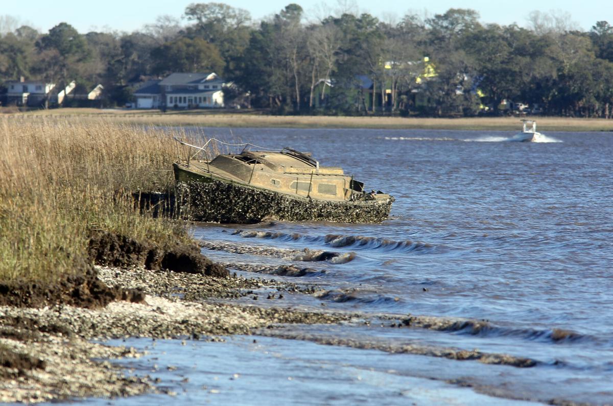
      Boaters have long used South Carolina’s public waterways to store or abandon their derelict vessels. If a new bill passes in the General Assembly, they may soon have to take responsibility for them.


      An abandoned sailboat rests in the pluff mud of the Ashley River near the Interstate 526 Westmoreland Bridge on Tuesday, February 16, 2021. Brad Nettles/Staff


      Charleston legislators introduce bill to crack down on abandoned boats in SC waterways
      Post and Courier

      Be the first to comment!

    • Shared Photo by Ted Arisaka


      Our thanks to Ted Arisaka for this beautiful sunset taken from Windmill Harbour Marina, A CRUISERS NET SPONSOR!


      From Windmill Harbour Marina,  A CRUISERS NET SPONSOR, Hilton Head, SC 

      Click Here To View the South Carolina Cruisers Net Marina Directory Listing For Windmill Harbour Marina

      Click Here To Open A Chart View Window, Zoomed To the Location of Windmill Harbour Marina

      Be the first to comment!

    • Warning on Dewees Inlet north of Charleston, SC, near AICW Statute Mile 455


      Between the Winyah Bay Entrance south of the AICW from Georgetown, SC and the Charleston, SC harbor entrance, there is really no safe inlet and Dewees Inlet carries this emphatic warning from Claiborne: WARN ANYONE OFF FROM USING THIS INLET. THERE IS NO CHANNEL TO SPEAK OF AND TO SAY IT’S TREACHEROUS IS AN UNDERSTATEMENT. IT COULD BE DEADLY!!!

      We are headed back off-shore to the south – Charleston, but would prefer Isle of Palms as it takes about two hours off the trip… if we can get in through Dewees Inlet. Charts show no marked channel to the outside but inside the water is charted deep (no channel markers), tides run 5+ feet and there are some tempting areas that may not be shoaled up. Does anyone know if this passage can be made safely with a ~6 ft. draw at HT? Thanks
      Captain Ric

      Click Here To Open A Chart View Window Showing the Location of Dewees Inlet

      Comments from Cruisers (1)

      1. Tom Duckett -  November 20, 2020 - 9:03 pm

        I know this is 10 years after the original post, but stay away from Dewees Inlet! Navionics had me take the outside route from McClellanville to Isle of Palms this morning because of low tide along the ICW. Well, I can tell you first hand that Dewees Inlet made me soil my shorts and need a few beers once inside. The approach consisted of many turns and following that magenta line to the "T". However, there was a northeast wind with swell coming from the northeast and the south. Everything was going fine, I was on the line and then my depth sounder started screaming low water. I draw 4'9" on my 37' Gulf Star and at 6' on the sounder with the swell, I kissed the bottom with the keel twice before finding deep water 100' to starboard (off the magenta line) on the edge of breaking waves. Halfway in I saw two large 40+' sport fishing boats turn around and say "Nope, not today". Water depth went from 30' to 6' in a matter of 100 yards and then back to 30+'. Once in calmer water, there was 40' depths the rest of the way. What a way to test the nerves of a new Captain. Next time, I'll take my chances running aground in the ICW. On a calm day, you might be able to get in or out of here, but I seriously don't suggest trying it.

        Reply to Tom

    Social Media Auto Publish Powered By : XYZScripts.com