[EXPIRED] Missing AICW Aid to Navigation (Statute Mile 817), December 6, 2012
This missing aid to navigation and its temporary replacement flank the east side of the Waterway south of Flagler Beach at Statute Mile 817.
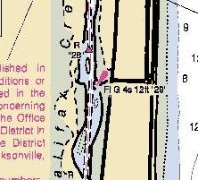
FLORIDA-ATLANTIC INTRACOASTAL WATERWAY-TOLOMATO RIVER-PALM SHORES-HALIFAX CREEK: Hazard to NavigationHalifax Creek Light 29 (LLNR 39815) is destroyed. The steel pile was broken approximately 1ft above the waterline. A TRLB “WR 29” with Fl Q G charateristics is set in position 29-23-28.286N/081-05-30.465W (29°23.4714N / 081°5.508W, 29.39119 / -81.0918). Mariners are advised to transit the area with extreme caution. Chart 11485![]() Click Here To Open A Chart View Window, Zoomed To A “Navigation Alert” Position at
Click Here To Open A Chart View Window, Zoomed To A “Navigation Alert” Position at


Be the first to comment!