Upcoming Florida Marine Exhibitor and Vendor Events, Treasure Coast, FL
Seafood Festival, Boat Show and Flea Market – what more could you want?
Click here for Featured Upcoming Florida Marine Exhibitor and Vendor Events
Seafood Festival, Boat Show and Flea Market – what more could you want?
Click here for Featured Upcoming Florida Marine Exhibitor and Vendor Events
The pilot on board the capsized car carrier Golden Ray deliberately took the vessel out of the channel and grounded her, according to a report in The Brunswick News. The 656-foot vessel capsized on September 8 in St. Simons Sound while heading out to sea with 4,200 vehicles onboard. See LNM Capsized Vessel.
Golden Ray: Rock Operations Commence
Maritime Executive
Inside Golden Ray – A cargo assessment has taken place on the ninth deck
Maritime Executive
Rocks to be Placed Around Golden Ray
Maritime Executive
White Smoke Coming from Golden Ray
Maritime Executive
Golden Ray to be Disassembled on Location
Maritime Executive
Overturned cargo ship to be disassembled in St. Simons Sound
WTOC via Chip Plyler on Save Georgia’s Anchorages
Pilot Deliberately Grounded Golden Ray
Maritime Executive Newsletter
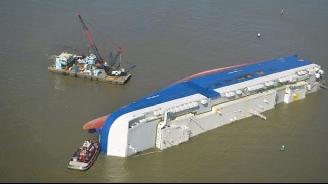
I went to the wreckage area in my boat and observed that the Golden Ray was lying perpendicular to the edge of the channel. To me, that adds credence to the intentional grounding theory.
Cruisers Net is not privy to any more details than mentioned in this report and cannot confirm or deny the accuracy of the report. We post this only because of the recent issues revolving around freedom to anchor. Further information should arrive soon.
Click here for Key West: FWC CAPTAIN SHOOTS LIVEABOARD ON HIS HOUSEBOAT
Once again, Jim Healy graciously imparts his experience in response to a Looper’s questions on AGLCA’s Forum with an excellent description of the Okeechobee Waterway. Jim is a true cruiser helping cruisers! Thank you Jim.
1) How many days should we anticipate to cross Florida going west at 9 knots. Currently thinking 1 day to Pt Mayaca, day 2 to Clewiston or Moore Haven, then day 3 and 4 from Moore Haven to Alva, FL (WP Franklin Lock).
“It all depends.” This trip is “Old Florida.” This is orange grove and sugar cane country. On the St. Lucie Canal, there are marinas at Stuart and Indiantown. There is a Corp Of Engineers dock at St. Lucie Lock with is $15/day with a Golden Age Pass. There’s not much/nothing to see at these stops, so one night overnights are typical for cruisers. A place to shower and sleep. So, typically, what we do is stop at the anchorage in Stuart. Then, Stuart to Clewiston. Then, Clewiston to Ft. Myers. I recognize that is a longer day than some people may want, but we do this trip twice a year, and as I said, very little to see. We stay at Roland Martin’s in Clewiston. Very nice Tiki Bar, and a relaxing place. Sammy the dockmaster is a wonder to enjoy. There are nice public docks in Moore Haven with power and water for $1.00 per foot. There are public docks at the library in Labelle. First come, first serve; Med Moorings. Good wifi. It’s the only place in the canal system to actually see a town. There is also a COE dock at the WP Franklin Lock; also $15/day with power and water. There are two locks on the St. Lucie Canal and three on the Caloosahatchee end. The highest lick is St. Lucie; around 16 feet vertical lift.
2) Where best to dock/anchor along the route?
You are permitted to anchor in the canal after closing at 1700. No one does [anchor] on the St. Lucie end except at the lock, on the north side.. You cannot anchor in the canals during the daytime hours of lock operation.
3) Is it better to cross the lake (route 1) or go the rim route (route 2)? What criteria to decide?
DO NOT TAKE THE RIM ROUTE WITH A 5′ DRAFT. PERIOD. We have never taken the Rim Route. The cross lake route is shallow enough, and even more so this year. The Southwest Water Management District has been holding the lake level down to avoid large water releases of the vile Lake O water into the canals. Not sure it’s doing any good, but check the Route 1 water depths. In the spring, we crossed when there was only 5′ of water, and the place that will affect you is the 5-mile channel from the lake into Clewiston.
4) What water level reading do we need from COE for our 5′ draft?
Five feet, of course. There are two places where the control depth is measured. One is in the channel out into the lake at Port Mayaca, the other is the channel from the lake into Clewiston. STAY IN THE CLEWISTON CHANNEL. The lake bottom is limestone, not sand. The Clewiston channel is dug, so the edges are rock. Much like the “Rock Pile” in South Carolina. There is no tide in the lake, but winds can change water levels at the north and south by as much as a foot or more. Watch winds that have been blowing for many days…
Bonus Question: What the current status of the Red Tide?
Yes. Red Tide is a problem on the gulf, not in the lake. IT IS A NATURAL PHENOMENA, NOT RELATED TO POLLUTION. It’s blue/green algae that you have to worry about in the canals and lake. Both conditions are problems in Florida. DO NOT SWIM IN THESE WATERS. They do contain nasty bacteria, but there are larger reptile hazards here, too. Big lizzagators live here. We wear nitrile exam gloves when handling lock lines.
Heading East to West consider 1) sunset bay marina & mooring field @ Stuart ( 2) transient docks at Indiantown Marina (3) Clewiston Roland Martins transient docks or Clewiston City Docks (4) Moore HAven City & (5) stop at Ft Myers City Marina at downtown There might be newer facilities since I have not crossed in many years. Enjoy.
Loved Franklin locks Campground and docks!

Bahamas Chatter is produced by Explorer Chartbooks, A CRUISERS NET PARTNER, which has long been the standard navigational supplement for enjoyable, informative, and safe cruising through the beautiful Bahamian waters and island visits.
Bahamas Chatter: New Fees for Cruising Permit
New Fees for Cruising Permit
Posted: 18 Oct 2019 07:50 AM PDT
As you prepare for a trip to The Bahamas, be aware of changes to the charges and length of stay given on your cruising permit.
The new policy on fees for pleasure vessels clearing into the Bahamas is:
Under 35ft–$150 for 3 months; $300 per year.
35-100ft– $300 for 3 months; $600 per year.
100-150ft–$500 for 3 months; $1,000 per year.
150-200ft–$800 for 3 months; $2,000 per year.
Over 200ft–$1,000 for 3 months; $2,000 per year.
The Federal Emergency Management Agency has denied North Carolina’s application to provide assistance to individuals in Dare, Hyde, Carteret and New Hanover counties who suffered losses due to Hurricane Dorian, OBX Today reported Wednesday. On 10/20 Fema granted request for additional funding to the community.

FEMA Denies Individual Assistance Request
Coastal Review Online and OBX Today
10/21 FEMA Grants Request for More Assistance
Coastal Review Online
A beautiful sunset shot by Cruisers Net Team member, Winston Fowler.

Some kind of sunset last night in Palmetto, FL Winston Fowler
Claiborne,
I tried this and it worked.
Took about fifteen minutes of discussion, but the officer, after making three phone calls, said he was not authorized to sign any document. He wished me a “good day” and left.
Captain Robert Lucas
S/V Aquitaine
Bradenton, FL
VESSEL BOARDING AGREEMENT
The Fourth Amendment (Amendment IV) to the United States Constitution is the part of the Bill of Rights which guards against unreasonable searches and seizures, along with requiring any warrant to be judicially sanctioned and supported by probable cause, “The right of the people to be secure in their person, houses, papers, and effects, against unreasonable searches and seizures shall not be violated….”
Search and arrest should be limited in scope according to specific information supplied to the issuing court, usually by a law enforcement officer, who has sworn by it.
In Mapp v. Ohio, 367 U.S. 643 (1961), the Supreme Court ruled that the Fourth Amendment applies to the states by way of the Due Process Clause of the Fourteenth Amendment.
In Katz v. United States, 389 U.S. 347 (1967), the Supreme Court ruled that the amendment’s protections apply only when the searched party has a “reasonable expectation of privacy”.
The Supreme Court has also ruled that certain searches and seizures violated the Fourth Amendment even when a warrant was properly granted.
Oath of Boarding Officer:
I ______________________________, acting as an officer of _________________________
assert that I have probable cause to board the vessel _________________________________ for the following reasons:
___________________________________________________________________________
___________________________________________________________________________
___________________________________________________________________________
I accept responsibly, under law, that this boarding is necessary and does not violate the protections of the fourth amendment to the constitution of the United States of America and the statutes of the state of _______________________.
I waive all legal rights to defense of this boarding that the Captain of this vessel may raise under law.
_________________________________________, Boarding Officer
As agent of ________________________________
Boarding is:
Granted _______ , ________________________________ , Captain , Date :_______________
Denied ________ , ________________________________, Captain, Date: _______________
Fourth Amendment -Vessel Boarding Agreement
BRAVO! and bravo again! I always wondered just which bureaucrat or politician gave up our Fourth Amendment rights regarding unreasonable search. My guess is that printers are humming already (if you’ve got one aboard). I hope we can find some more results of this tactic!
Capt Mike
S/V Blue Skye
Captain Lucas:
In checking the regs, I found:
Coast Guard may go aboard any United States vessel at any time, anywhere to conduct a documentation and safety inspection.
A search of a U.S. vessel beyond this type of inspection is subject to limitations under the United States Constitution. If a search extends beyond this narrowly defined scope, a court may be asked to evaluate the legality of the search by balancing the individual’s right to privacy in the specific circumstances of the search against society’s interest in detecting criminal conduct.
Captain Whitney
I printed it. We’ll see!
Kevin R. Quinn
Certain officials have standing search warrants. The Coast Guard does indeed have a standing warrant for the purpose of determining the seaworthiness of a vessesl for the intended purpose(voyage). A fire fighting offical has a standing warrant to enter a building for the purpose of fighting a fiire and for rescue purposes. Why would we need to ask any official to sign anything? Just ask them for the warrant that they have!! If it is a standing warrant, they must still provide proof. If they do not have a court approved warrant, deny the boarding!
Thomas P. Sangston
Our thanks to Jim Healy for reminding AGLCA’s Forum readers about AIWC trouble spots and let us remind you about Cruisers Net’s easy to research, state by state and region by region listing of Problem Stretches from North Carolina to Florida. Open ink below for Hell Gate Problem Stretch in which dredging was completed on October 1, 2019.
There are several “Hell Gates” around (Maine, New York, Georgia), but the one this post refers to is at MM600 in Georgia, between the Ogeechee and Vernon Rivers. “Heading north to Savannah…” from – let’s say – Florida, you will have to pass through Georgia’s version of Hell Gate.”
The tides in that part of the East Coast run to 8 feet or so; there are SEVERAL known ICW trouble spots in that region that become issues at low tide and especially at celestial low tides. You WILL want to know about them. Altamaha Sound, The Little Mud River, Hell Gate and Elba Cut all come to mind. Start with Tom Hale’s great information at Sail Magazine (https://www.sailfeed.com/2019/09/icw-observations-updates-september-2019/). Join the Facebook Group run by Bob Sherer (Bob423) called ICW Cruising Guide. Facebook is so hard to use and get meaningful information from quickly that you might be better off with Bob’s website first, at Fleetwing.blogspot.com. These two guys are actively cruising the ICW seasonally, so their information is both timely and current.
If you don’t have Aqua Maps Master for a cell phone of tablet, get it. The Master add-on gives you US Army Corps of Engineers sounding information that is highly useful.
You don’t say where you’re starting, but there are several historic trouble spots in North Florida, too. READ UP ON THE ICW BEFORE YOU GO, or make sure your towing insurance is paid up… (OK. That was stupid… I lost track of the subject line. But if you’re familiar with Jekyll Creek – and the history thereof – you should understand the words “ICW Trouble Spots” all too well…)
![]() Click Here To View the Cruisers’ Net’s AICW Problem Stretches Listing For Hell Gate
Click Here To View the Cruisers’ Net’s AICW Problem Stretches Listing For Hell Gate
![]() Click Here To Open A Chart View Window, Zoomed To This AICW Problem Stretch
Click Here To Open A Chart View Window, Zoomed To This AICW Problem Stretch
Longboat Key Club Moorings, A CRUISERS NET SPONSOR, is located on the western shores of Sarasota Bay, north of the city of Sarasota and south of Longboat Pass.
The Resort at Longboat Key Club Voted in Condé Nast Traveler Readers’ Choice Awards
TOP 30 RESORTS IN FLORIDA
Click here for Pop the Cork, We Won!
Click Here To Open A Chart View Window, Zoomed To the Location of Longboat Key Club Moorings


Be the first to comment!