Visit Logged
  • Select Region
    • All Regions
    • VA to NC Line
    • North Carolina
    • South Carolina
    • Georgia
    • Eastern Florida
    • Western Florida
    • Florida Keys
    • Okeechobee Waterway
    • Northern Gulf
    • Bahamas
    • New York
    • Ohio
    • Pennsylvania
    • Washington
    • Puerto Rico
    • Minnesota
    • Maryland
    Order by:
    • Tangier, the Sinking Island in the Chesapeake


      Tangier Island is a very special place, definitely one of those never-to-be-forgotten spots in the Chesapeake. If you have not visited this step back in time, do it now before it’s gone.

      A combination of storm-driven erosion and sea-level rise, which are both increasing as climate change advances, may soon swallow the island entirely.

      Tangier, the Sinking Island in the Chesapeake  from The New Yorker

      Be the first to comment!

    • Bahamas Chatter: SSB Weather

      Explorer Charts - the best charts for the Bahamas and Exumas

      Explorer Chartbooks, A CRUISERS’ NET PARTNER, has long been the standard navigational supplement for enjoyable, informative, and safe cruising through the beautiful Bahamian waters and island visits.

      Bahamas Chatter: SSB Weather
      SSB Weather

      Posted: 09 Jun 2018 03:57 AM PDT

      Hi All,
      We will be cruising the lower Exumas and SE Bahamas in June. Can anyone direct me to a resource for SSB frequencies and schedules for weather broadcasts.
      Thank You!

      Comments from Cruisers (1)

    • World Ocean Month – Volunteer To Protect Your Marine Sanctuary

      Gray’s Reef National Marine Sanctuary protects Georgia’s special live-bottom wildlife habitat in the Atlantic Ocean and along the southeastern U.S. coast, an area teeming with diversity and an abundance of marine life.


      GRNMS Header

      Volunteer To Protect Your Marine Sanctuary

      The Gray’s Reef Sanctuary Advisory Council provides the Office of National Marine Sanctuaries with advice and recommendations on the management of Gray’s Reef National Marine Sanctuary. The council members include community stakeholders from fishing, diving, conservation, science, education, citizens-at-large, state agencies, and federal agencies.

      We are currently accepting applications for the following council seats:

      • Charter/Commercial Fishing
      • Sport Diving
      • Sport Fishing
      • Non-living Resources Research
      • University Education
      • Citizen-at-Large
      • Conservation (2 seats)

      Applications are due by July 23, 2018.

      Click here for more information, including a copy of the application. Contact Advisory Council Coordinator Becky Shortland with questions at: becky.shortland@noaa.gov or (912-598-2381)


      Celebrate World Ocean Day all Month long!

      Tybee Island Beach Clean-Up

      Gray’s Reef National Marine Sanctuary is celebrating World Ocean Day at the University of Georgia Marine Education Center and Aquarium on Friday, June 8 (10:00 a.m. to 3 p.m.). 

      On Saturday, June 9, help the Gray’s Reef NMS Foundation and friends with a beach cleanup on Tybee Island. Meet the Tybee Clean Beach Volunteers at the Pier and Pavilion at 9:00 a.m. For a parking pass and volunteer t-shirt, be sure to register here.

      We wrap up June with Georgia Department of Natural Resources Beach Week events on Tybee and St. Simons Islands, June 28 & 29. Learn all about Georgia’a wild Atlantic coast and underwater treasures during World Ocean Month!


      Gray’s Reef National Marine Sanctuary

      graysreef.noaa.gov

      Be the first to comment!

    • Bahamas Jumping Off Spot, Old Port Cove and North Palm Beach Marinas, AICW Statute Mile 1014


      Old Port Cove Marina, A CRUISERS’ NET SPONSOR, is located on the western shore of the northern Lake Worth channel, near unlighted daybeacon #7. North Palm Beach Marina is found on the southwestern banks of the Waterway south of the North Palm Beach/Parker Bridge.


      Click Here To View the Eastern Florida Cruisers’ Net Marina Directory Listing For Old Port Cove Marina

      Click Here To Open A Chart View Window, Zoomed To the Location of Old Port Cove Marina

      Click Here To View the Eastern Florida Cruisers’ Net Marina Directory Listing For North Palm Beach Marina

      Click Here To Open A Chart View Window, Zoomed To the Location of North Palm Beach Marina

      Be the first to comment!

    • Bimini Entrance Buoy Update by Greg Allard

      Our thanks to Greg Allard for this onsite report and photos from Bimini.

      Bimini Entrance Buoy Update – as of May 31/June 1, 2018
      from Greg Allard

      1) When approaching Bimini, at the harbor entrance, there are three buoys, two red and one green.

      2) The red buoy, furthest to the north, is off-station, and it sits on a sandbar. Ignore it.

      3) The other two buoys, one green and one red, are used to enter the harbor.

      4) As you approach, look for the narrow rock lined entrance into Bimini Sands Marina on South Bimini. You will see the other two entrance buoys, generally lined up with the entrance to Bimini Sands. These are the two buoys you will use.

      5) Navigating eastward, the first buoy (red) is the western most buoy of the two; the second buoy is further east, and is green, and it appears very near to the shore in front of Bimini Sands.

      6) As to the first red buoy, to us it appeared that there was deeper water to the right of it (as we entered.) That is, the water appeared deeper on the south side of that red buoy. That is the path we took, and there was 12’ plus depth. Many local boats (or non local boats following everyone else) passed the red one on the “correct” side, that is, they left the red to their starboard. The water there looked “OK”, but not as deep as the water on the south side of the red.

      7) After passing the red, then head for the green buoy. There appears to be a sandbar that has crept south slightly into the channel before the green buoy, so you should swing slightly to the south to clear it. If you are going to North Bimini, pass the green buoy as you would normally (to port), and then make an approximate 90 degree turn to port (north) which will take you into the well marked channel towards North Bimini. (If you are going into Bimini Sands, put the green to your port and go straight in to the entry channel which according to the dockmaster, has 6’ at low tide; I believe he is correct from what we saw.)

      We did not go into N. Bimini, but at almost low tide, in the outer entry channel near the red and green buoys, we consistently had 10”+ of water depth. That of course is based on the exact route we took. As they say: your depth may vary. See the important note below.

      Here are some photos, which will help illustrate the route.

      View looking EAST. Bimini Sands marina is in the background. The red buoy you will use to enter is in the left foreground.  We are passing on the “wrong” side, since the water appeared deeper to us there.
      The buoy further away is the green, which as you enter you should leave to port, and then turn north (to port) about 90 degrees to pick up the clearly marked channel into N. Bimini.
       

      This is the view of the same two “good” buoys, looking WEST, coming out of Bimini Sands.

      The view looking NORTH from the “good” red buoy.  In the far left distance, is the off-station red buoy which you don’t want to use for anything, since it is on a sandbar.
       
      NOTE:  We watched many small boats pass the red on the “correct” side, but then we observed a steel freighter about 150’ long coming south out of N. Bimini. 
      she turned west at the green near shore, and then she passed the RED on her starboard side – that is what would normally be the “wrong” side.
       
      In other words, that boat confirmed for us that the deeper water is on the south side of the red buoy.

      Be the first to comment!

    • Bahamas Chatter: Latest on the Berry Islands Club

      Explorer Charts - the best charts for the Bahamas and Exumas

      Explorer Chartbooks, A CRUISERS’ NET PARTNER, has long been the standard navigational supplement for enjoyable, informative, and safe cruising through the beautiful Bahamian waters and island visits.

      Bahamas Chatter: Latest on the Berry Islands Club
      Latest on the Berry Islands Club

      Posted: 05 Jun 2018 09:06 AM PDT

      New Information from the Chub Cay Resort regarding the Berry Islands Club:

      The Berry Island Club has been closed from the summer 2016. They sustained major damage during hurricane Matthew of that year.

      The owner of Chub Cay Resort purchased it earlier this year and hopes to have it open for November- December of 2018 as a Bonefish Lodge. It will be another getaway for guests staying at the Chub Cay Resort.

      Be the first to comment!

    • Bahamas Chatter: Increase in VAT to 12%!

      Explorer Charts - the best charts for the Bahamas and Exumas

      Explorer Chartbooks, A CRUISERS’ NET PARTNER, has long been the standard navigational supplement for enjoyable, informative, and safe cruising through the beautiful Bahamian waters and island visits.

      Bahamas Chatter: Increase in VAT to 12%!
      Increase in VAT to 12%!

      Posted: 03 Jun 2018 02:53 PM PDT

      Effective July 1, 2018, the Bahamas VAT will increase to 12%. This increase will be devastating! If you search on-line, you can read much more about the controversy. The only concession they’ve made for the residents is that some “breadbasket” food items will be VAT free, but the list is VERY specific & VERY short. This will hurt businesses too, especially restaurants – this new VAT along with a 18% gratuity will result in 30% onto a restaurant bill – Yikes!

      We cruisers aren’t going to like this either. Also announced were a slew of various other increases including immigration fees – unknown yet if that will include Cruusing Permit fees…

      Russ

      Be the first to comment!

    • 2018 Letters from the Bahamas # 5 by Greg and Barbara Allard

      Our sincerest thanks to Greg and Barbara Allard for sharing their thoughts and beautiful photography from their Bahamas cruises. These photos and descriptions will have you aching to follow in the Allard’s wake! Hopefully there will be more letters in the weeks ahead.

      Letter # 5

      Hello everyone:
      Once again we’ve had to send two Letters in close succession, to take advantage of the good internet connection at this marina. This is likely to be the last Letter for a couple of weeks.

      Our report from Long Island continues.

      Barbara and I both grew up on Long Island, the one in New York, which is 120 miles long and has a current population of 7.8 million.

      The other Long Island, the one where we are at the moment, is in the Bahamas. It is 80 miles long, has a population of 3,500 people and there is not one traffic light on the entire island.


      Once we entered the waters towards the southern end of Long Island, we had a small milestone event: we crossed the Tropic of Cancer. This sign on Long Island shows the location of the line, and once south of it, we were officially in tropical waters.

      Jerome Hawes was born in 1876, and studied for five years at the Royal Institute of British Architecture. He then undertook studies at the Lincoln Theological College, became Father Jerome, an Anglican priest, and in 1910 designed this church on a hill above Clarence Town on Long Island. He later went to Rome, studied for three more years to become a Catholic priest, and then in 1939 designed the Catholic church on the far hill, to the right rear of the photo. Local sources say that the Catholic church was not completed until 1946. Both churches were strongly built to survive the frequent hurricanes; they still stand proudly over the town.

      Father Jerome’s Catholic church.

      While we were looking at the Anglican church, the woman on the left came up to me and allowed us to go inside. She is a member of the congregation. She was also excited to show us her new home, and gave us directions to get there. Her name is Sandra Dean, and her husband is Jeremiah.

      This is their new home, which sits on a beautiful hill overlooking the harbor and the ocean. They gave us a tour and we found it to be simply furnished and filled with beautiful breezes from the sea. This house was built to replace their prior one which was destroyed in a hurricane.

      We stopped at the Glinton School in the northern part of Long Island, to drop off some school supplies. We met the principal, Ruth Smith, on the left, and her assistant Claudette Adderley. They gave us the warmest welcome.

      No visit to a school is complete without some pictures of the children. The Bahamian educational system is excellent, the children are well disciplined, and many go on to higher education. There are 34 students enrolled at this school, and some of them are shown here and below.


      One of the teachers, Tangela Bain.

      We met Stanley Pinder, a farmer on Long Island. He gave us some of his beautiful just-picked peppers. He’s over 80 years of age, and has lived on the island his entire life, save for a few years in the U.S. as a farm worker. Long Island is one of the few Bahamian islands which has a flourishing agricultural industry. In fact, they grow enough produce to export it to other Bahamian islands.

      A Bahamian “fast food” restaurant. Regular menu items would be chicken or ribs, mac and cheese, beans and rice, all served in a square styrofoam lidded box. These places do a good lunch business.

      Alfred, who with his wife operates this small bake shop. We bought loaves of white bread, some cinnamon buns and a delicious piece of lemon cake.

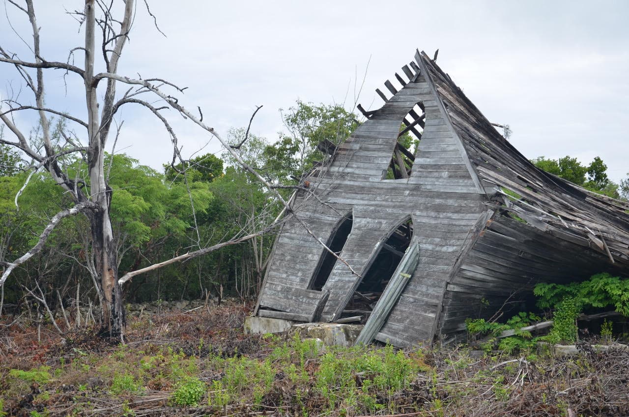
      It’s likely that a combination of old age and a hurricane or two destroyed this church. The Bahamians are a religious people – even the smallest of towns have at least one or two churches.

      At the French restaurant, Chez Pierre. A fine lunch, good wine and a great companion.

      St. Mary the Virgin Anglican Church, now in ruins, reported to have been built by the Spanish in the late 17th century. Hopefully, it will someday be restored.

      We collect Bahamian baskets, first of all because we like them, but more importantly because the Bahamians who make them are skilled artisans who carry on a trade which may not last forever. Over the years we have visited Ena Majors’ shop in Clarence Town, where she showcases high quality baskets made by local people. Our friends and us bought the ones on the counter.

      Ena Majors. She is 82 years of age.

      Long Island is the home of Dean’s Blue Hole, a spectacular 660’ deep hole, reputed to be the deepest in the world. It is supposedly connected to the ocean at its bottom.
      This is the site of yearly competitions with participants from all over the world, to see who can set a record by going down the deepest while holding their breath, without SCUBA, or any other devices. Some of the contestants reach 250+ feet. The white raft in the middle has a line which the divers use to guide them. It is an extremely dangerous sport. On the rock to the left of the picture, surrounded by three cherubs, is a plaque listing the people who have died while diving here. The cause their deaths, simply stated, is blacking out from lack of oxygen.
      My task is to send Letters, not to make judgments.

      We went looking for the delicious pineapples which are grown on Long Island, but it was a bit early in the season. In Turnbull, we met Leroy Gibson while he was walking along a road, and the conversation turned from pineapples to other subjects. He liked to verbally joust, and when I eventually asked to take his picture, he said: “I never want my picture taken, but you can take it.” This is the result.

      DCIM100GOPROGOPR1279.

      Life can be difficult in the Bahamas. Fishing is one of the main ways to earn a living. This fisherman’s boat, Lady Max, dragged her anchor, and came to rest in shallow water. It will be difficult to salvage the boat, and his livelihood.

      There was one day where the sun poked out for a couple of hours, and we were rewarded with this view. Look carefully at the name of the boat.

      Hopefully this rainbow is a sign that better weather is on the way. When that happens, we can head north again, back through the Exumas.

      Warm regards-
      Greg and Barbara
      Copyright, Greg Allard

      Be the first to comment!

    • Bahamas Chatter: Official Email from US Customs about New CBP ROAM

      Explorer Charts - the best charts for the Bahamas and Exumas

      Explorer Chartbooks, A CRUISERS’ NET PARTNER, has long been the standard navigational supplement for enjoyable, informative, and safe cruising through the beautiful Bahamian waters and island visits.

      Bahamas Chatter: Official Email from US Customs about New CBP ROAM
      Official Email from US Customs about New CBP ROAM
      Posted: 31 May 2018 10:27 AM PDT

      INTRODUCING A NEW OPTION FOR REPORTING YOUR PLEASURE BOAT ARRIVAL TO CBP

      Hello SVRS member,

      It is our pleasure to announce that U.S. Customs and Border Protection (CBP) is launching the CBP Reporting Offsite Arrival – Mobile (ROAM) app, a new way for pleasure boaters to report their U.S. entry in select locations nationwide! This app provides pleasure boaters with a convenient and efficient way to report their U.S. entry from a personal device, as opposed to calling their local CBP number. Please note: Float plans are no longer required, and the Small Vessel Reporting System (SVRS) is being discontinued in the coming months. A notice will be posted to the SVRS website with a specific date and thereafter all travelers will be directed to utilize the CBP ROAM app. Your SVRS, Local Boater, or Registered Traveler numbers will remain in effect and can be utilized and saved within the app to expedite reporting.

      What is the CBP ROAM app?

      The CBP ROAM app is a free mobile application that provides a new and faster option for pleasure boaters to report their U.S. entry to CBP. Travelers can use their personal smart device (or a tablet located at partner businesses) to satisfy reporting requirements in select areas. All travelers, regardless of nationality or citizenship, are eligible to use the CBP ROAM app.

      Where can the CBP ROAM app be used?

      Currently, the CBP ROAM app can be used to report U.S. entry by pleasure boat in Florida, select locations in Minnesota, and in the Great Lakes and Saint Lawrence River area between Buffalo and Ogdensburg, NY. Additional locations are being added, and travelers should contact their local port of entry to confirm whether arrival submissions via the CBP ROAM app are accepted.

      Download CBP ROAM on your Android or Apple device! Detailed instructions on how to install and use the app on a personal device are attached for your reference. Click Here to download CBP ROAM App Instructions.pdf

      For more information on the CBP ROAM app, visit the CBP ROAM page on CBP’s website. For CBP ROAM questions or comments, please reach out to cbproam@cbp.dhs.gov.

      This program is a pilot and is still under development; please report any difficulties or comments to this email box and we will respond as quickly as possible.

      Happy boating and stay safe!

      U.S. Customs and Border Protection

      Click Here to download CBP ROAM App Instructions.pdf

      Be the first to comment!


    Social Media Auto Publish Powered By : XYZScripts.com