Visit Logged
  • Select Region
    • All Regions
    • VA to NC Line
    • North Carolina
    • South Carolina
    • Georgia
    • Eastern Florida
    • Western Florida
    • Florida Keys
    • Okeechobee Waterway
    • Northern Gulf
    • Bahamas
    • New York
    • Ohio
    • Pennsylvania
    • Washington
    • Puerto Rico
    • Minnesota
    • Maryland
    Order by:
    • LNM: AICW MM 536 Schedule Change, Ladys Island Bridge, Beaufort, SC


      Three and a half hours to accommodate “rush hour” vehicle traffic twice daily seems extreme, especially during summer months. Please see Comment Portal link below to submit your opinions. With a closed vertical clearance of 30ft, the Ladys Island Bridge crosses the Waterway at statute mile 536 on the eastern edge of Beaufort. Vessels capable of transiting without an opening may pass under the bridge.

      SOUTH CAROLINA – AICW (BEAUFORT RIVER) –LADY’S ISLAND (WOODS MEMORIAL) BRIDGE: Rulemaking / Temporary Deviation:
      The Coast Guard is proposing to change the operating schedule that governs the Lady’s Island (Woods Memorial) Bridge across the Atlantic Intracoastal Waterway (Beaufort River), mile 536.0, at Beaufort, SC. SCDOT has requested a permanent change to the drawbridge operation regulation for the Lady’s Island (Woods Memorial) Bridge. This temporary deviation will test an operating schedule to determine if a permanent change is necessary.
      Under this temporary deviation, the Lady’s Island (Woods Memorial) Bridge shall open on signal; except that the draw need not open from 6 a.m. to 9:29
      a.m. and 3:31 p.m. to 7 p.m., Monday through Friday, except Federal holidays. Between 9:30 a.m. and 3:30 p.m., Monday through Friday, except Federal holidays, the draw need open only once an hour on the half hour. Public vessels of the United States and tugs with tows, will be passed through anytime.
      This temporary deviation is effective from 12:01 a.m. on March 25, 2024, through 11:59 p.m. on September 29, 2024. A request for comments will be published in the Federal Register. Comments may be submitted under docket number USCG-2024-0198 using Federal Decision Making Portal at https://www.regulations.gov. If you have questions on this rulemaking, call or e-mail Ms. Jennifer Zercher, Bridge Management Specialist, Seventh
      Coast Guard District, telephone 305-415-6740, email Jennifer.N.Zercher@uscg.mil. LNM: 10/24

      Click Here To View the Cruisers Nets South Carolina Bridge Directory Listing For Ladys Island Bridge

      Click Here To Open A Chart View Window, Zoomed To the Location of Ladys Island Bridge

      Be the first to comment!

    • LNM: Coast Guard Urges Hilton Head and Beaufort Area Mariners: Check Your VHF Radios


      Coast Guard Sector Charleston command center watchstanders received multiple uncorrelated distress calls on the digital selective calling (DSC) system carried over a VHF marine radio in the Hilton Head and Beaufort area over the past few months.

      united states coast guard

      Coast Guard requests mariners inspect VHF marine radios

      CHARLESTON, S.C.— The Coast Guard has received multiple uncorrelated distress calls on the Digital Selective Calling (DSC) system carried over a VHF marine radio in the Hilton Head and Beaufort, South Carolina area over the past few months.

      These DSC calls are originating from an unregistered radio displaying an MMSI address of 100000001. 

      The first signal was received by the Coast Guard on April 26, 2021, ceased in July of 2021, and resumed intermittent transmissions in February 2022, causing interference with marine radio traffic in the Hilton Head and Beaufort, South Carolina area.

      False distress calls have the potential to mask genuine distress calls and overwhelm the search and rescue system’s ability to respond to emergencies. The Coast Guard urges all mariners to check their VHF radios and contact the Coast Guard if you have any information about the faulty radio at 843-740-7050.

      -USCG-

      AREA SPONSORING MARINAS

      Click Here To View the South Carolina Cruisers Net Marina Directory Listing For Harbour Town Yacht Basin

      Click Here To Open A Chart View Window, Zoomed To the Location of Harbour Town Yacht Basin

      Click Here To View the VA to NC Cruisers Net Marina Directory Listing For Shelter Cove Harbour and Marina

      Click Here To Open A Chart View Window Zoomed To the Location of Shelter Cove Harbour and Marina

      Click Here To View the South Carolina Cruisers Net Marina Directory Listing For Windmill Harbour Marina

      Click Here To Open A Chart View Window, Zoomed To the Location of Windmill Harbour Marina

      Be the first to comment!

    • Heart of the Lowcountry by Bob Arrington


      The Lowcountry of South Carolina is not only a place, but also a way of life. The next time you travel the South Carolina Intracoastal waterway, take the time to pull into Beaufort, home of Downtown Marina of Beaufort, A CRUISERS NET SPONSOR!

      Heart of the Lowcountry
      Soundings

      Click Here To View the South Carolina Cruisers’ Net Marina Directory Listing For Downtown Marina

      Click Here To Open A Chart View Window, Zoomed To the Location of Downtown Marina of Beaufort

      Be the first to comment!

    • Healy Report: Port Royal, SC to Walburg Creek, GA, AICW Statute Miles 539 to 619N or 623.5S


      Walburg Creek shapes the east side of Walburg Island and the Waterway lies on the west side. Good depths and great beach combing. My young daughters always declared the beach spooky because of the skeletal trees and dense forest to the east! While the creek has both a northern and southern entrance from the AICW, we prefer the northern passage, though there is still an unmarked shoal northwest of Middle Ground in St. Catherine’s Sound which must be bypassed. Experienced cruisers, Jim and Peg Healy, continue to generously share their observations and advice as they make their way south for the winter. Thank you Jim and Peg!

      On Monday, 10/29/2018, Sanctuary and crew travelled from Port Royal, SC to Walburg Creek, GA. Following, some observations:

      We arrived at Ramshorn’s Cut at 10h15 with the tide station at Daufuskie Island (Daufuskie Landing) showing 5.8+ rising. We saw 11.0 ft, so (11.0 – 5.8) = 5.2′ at MLLW. The channel between G39 and R40 has narrowed further. We took the visual center.

      We arrived at the un-named connector between the New River and the Wright River at 10h38 with the tide station at Daufuskie Island (Hargray Pier) showing 6.2+ rising. We saw 12.2 ft, so (12.2 – 6.2) = 6.0′ at MLLW. Follow the visual center. Honor, but stay away from, the lateral markers on pilings.

      We arrive at Field’s Cut at 11h06 with the tide station at Field’s Cut showing 7.6+ rising. Southbound, take the visual center between G47 and R48, and line up on Field’s Cut. HONOR R48A, which appears off-station to the East. We saw 11.2 ft passing about 25 ft off R48A, so (11.2 – 7.6) = 3.6′ at MLLW. This was a surprise! We followed the visual center of Field’s Cut, favoring the outside radius of the turns. That 3.6′ area was the control depth of the cut. Cross-currents are significant at the Savannah River. Be alert for river traffic and cross currents.

      There was a large, working crane barge at the Causton Bluff bridge. It appears “they” are replacing that bridge with a high rise. Another surprise.

      We arrived at Hell Gate (MM600) at 14h18, with the Egg Islands Tide Station reporting +7.0 falling. Depths we saw:
      G87 13.5′
      G89 10.4′
      9.8 low water between markers
      R90 10.9
      G91 10.4

      So (9.8 – 7.0) = 2.8′ MLLW. Also note, as you enter this cut from the Vernon River, there is a STRONG cross current that will try to sweep you sideways. Boats will need some power and some aggressive steering to stay on the best route. We crabbed into the lee of the current at about a 20° angle. There is a prominent visual distraction just to the west of the marked channel. There is a piling left over from some previous danger mark standing prominently, while the red and green floaters that mark the channel are low to the water and hard to see. Do not confuse that piling as a valid channel marker. Follow and honor the cans and nuns in the water

      Net: the overall condition of the A-ICW continues to deteriorate. Most cruising boats will need some tide help to get through this section. Plan accordingly.

      Jim
      Peg and Jim Healy aboard Sanctuary, currently at Charlotte Harbor, Punta Gorda, FL
      Monk 36 Hull #132
      MMSI #367042570
      AGLCA #3767
      MTOA #3436

      Click Here To View the South Carolina Cruisers’ Net Marina Directory Listing For Port Royal Landing Marina

      Click Here To Open A Chart View Window, Zoomed To the Location of Port Royal Landing Marina

      Click Here To View the Georgia Anchorage Cruisers’ Net Anchorage Directory Listing For the Walburg Creek Anchorage

      Click Here To Open A Chart View Window, Zoomed To the Location of the Walburg Creek Anchorage

      Comments from Cruisers (1)

      1. Richard Ross -  November 9, 2018 - 7:24 pm

        Passed thru Fields Cut on Nov 9, 2018, and found a minimum of 8 feet MLW at north end of Fields Cut. But there are two possible "gotchas". R48A appears to be off station, but it is not. For best water pass half way between R48A and the eastern shore. Also, be aware that once you turn to enter Fields Cut, (if southbound) you will be subject to strong cross currents.

        Reply to Richard
    • Healy Report: Mount Pleasant, SC to Beaufort, SC, AICW Statute Miles 465-536.5


      Experienced cruisers, Jim and Peg Healy, continue to generously share their observations and advice as they make their way south for the winter. Thank you Jim and Peg! Fenwick Cut slices through a narrow neck of Fenwick Island and connects the Ashepoo River with the Stono, north of the infamous Ashepoo-Coosaw Cutoff, a Cruisers Net Problem Stretch.

      Today is Saturday, 10/27/2018. Sanctuary and crew traveled 75 StM from Mount Pleasant, SC to Beaufort, SC. High tide in the region was right around 12h00.

      The Dredge Tenacious is working at the northern entry to the Dawho River. The Dredge answers on VHF 13 and VHF 65. The Dredge DOES NOT monitor VHF 16, which was a severe surprise and consternation to a lot of pleasure craft today, who nevertheless continued valiantly to try to raise him on VHF 16. Approach the dredge slowly, and follow his directions. Don’t forget to thank him for his work, which of course is to our benefit!

      We entered Watts Cut at the McKinley-Washington bridge at 11h30. The minimum we saw in the cut was 13.7′ at +7.7′ on the tide. That makes the control depth (13.7 – 7.7) = 6.0 ft at MLLW. We followed the visual center of the cut except I cut the corner at Green 135. DO NOT cut the corners. Where I was, I would have had a problem of the muddy sort at low tide.

      We entered Fenwick Cut at about 12h30. The tide station at Edisto Beach was reporting +5.6′. We saw 12.4′ in the cut, so control depth was (12.4 – 5.6) = 6.8 ft. Southbound, we saw red lateral R162 on a piling. The chart shows a red R162A on a piling and a floating R162B. There is a piling there for R162A, but no dayboard is present. We did not see a floating Red nun there, either. Net is, come down the S. Edisto river, and turn into the center of the cut. There is shoaling along both shorelines, so don’t cut the corners. Line up and go through along the visual center.

      The Ashepoo-Coosaw Cutoff is in two halves. Southbound, we entered the northern half at 12h45, with the tide station in that cut showing +6.2. Depths were in the range of 17 feet, so I didn’t pay much attention there. The southern half was dredged in the spring of 2018. There was severe shoaling at the junction of the Cut with the Coosaw River. We cleared that area at 13h00, with the tide at +5.8. We saw 11.9′ depths in the visual center of the entrance between G164 and R185, so the control depth would be (11.9 – 5.8) = 6.1 ft. I guess I would say the spring dredging helped at the junction of the Coosaw river, but did not do much to otherwise deepen the southern half of the Ashepoo-Coosaw Cut. At least most boats don’t have to do the St. Helena Sound route at this time.

      We’re just coming off full moon. We faced strong 2.5 kt ahead currents on and off all day, and particularly up-stream on the Coosaw River. That made for a tedious slog up the river. But at the divide at Brickyard Creek on the Beaufort River, we picked up speed and did very well for those last 8 miles into Beaufort. These strong flood and ebb currents will affect slow boats.

      Jim

      Peg and Jim Healy aboard Sanctuary, currently at Charlotte Harbor, Punta Gorda, FL
      Monk 36 Hull #132
      MMSI #367042570
      AGLCA #3767
      MTOA #3436

      Click Here To Open A Chart View Window, Zoomed To the Location of Fenwick Cut

      Click Here To Open A Chart View Window, Zoomed To Ashepoo-Coosaw Cutoff Problem Stretch

      Be the first to comment!

    • Praise for Downtown Marina of Beaufort, SC, AICW Statute Mile 536.5


      A CRUISERS’ NET SPONSOR!, Downtown Marina is located north of AICW marker #239, a short distance west of the Lady’s Island swing bridge, in the heart of downtown Beaufort. Our thanks to Charlie and Jackie for these good words.

      9-20-18. Over night at Downtown Marina at Beaufort. As usual terrific spot. Deck hand Troy- very experienced and nice- helped with lines. On inside of face dock. Bath house nice, decent ships store. And the most very nice ladies that take reservations are in the store. Pleasure to deal with. Always a must stop- especially with all the restaurants, shops, etc all so close. There is a new day dock- just for transients to tie up for lunch, etc. Very large and substantial– even looks nice. Good wifi and many air tv channels, but they also have cable.
      Charlie and Jackie on Traveler

      Click Here To View the South Carolina Cruisers’ Net Marina Directory Listing For Downtown Marina

      Click Here To Open A Chart View Window, Zoomed To the Location of Downtown Marina of Beaufort

      Be the first to comment!

    • A Good Ride from Beaufort to Isle of Palms, SC, AICW Statute Mile 536-459

      Isle of Palms Marina is located on the east side of the Intracoastal Waterway, northeast of Charleston at Mile 456.5 and south of ICW Marker 116. 50 41st Avenue

      77 Miles in one day – that is definitely a good day’s run, especially through the numerous shallow spots in that stretch. Such tidal luck may be a once in a lifetime occurrence! And that fact that both Downtown Marina of Beaufort and Isle of Palms Marina of Charleston are CRUISERS’ NET SPONSORS had a lot to do with it! Well done Phillip.

      Left Beaufort South Carolina two hours after low tide from the downtown Marina and caught the incoming tide up the Beaufort River it continued through the Coosaw back into the Waterway and all the way back to Isle of Palms. Could not believe it. 42-foot sail and we averaged 6.6 knots. Saw 7.5 and 8.10 several times. Never had a head current. Could not believe it. Please pass this along to the Northbound Cruisers this spring.

      This trip usually takes us two days but on this occasion it took 10 hours.
      Phillip Mullins

      Click Here To View the South Carolina Cruisers’ Net Marina Directory Listing For Downtown Marina

      Click Here To Open A Chart View Window, Zoomed To the Location of Downtown Marina of Beaufort

      Click Here To View the South Carolina Cruisers’ Net Marina Directory Listing For Isle of Palms Marina

      Click Here To Open A Chart View Window, Zoomed To the Location of Isle of Palms Marina

      Be the first to comment!

    • Update on Ladys Island Bridge Schedule, AICW Statute Mile 536, Beaufort, SC


      With a closed vertical clearance of 30ft, Ladys Island Bridge crosses the Waterway at Statute Mile 536 immediately north of Beaufort. Our thanks to Mandy Griffin of Downtown Marina of Beaufort, A CRUISERS’ NET SPONSOR, for this updated schedule.


      Click Here To View the Cruisers’ Net’s South Carolina Bridge Directory Listing For Ladys Island Bridge

      Click Here To View the South Carolina Cruisers’ Net Marina Directory Listing For Downtown Marina

      Click Here To Open A Chart View Window, Zoomed To the Location of Downtown Marina of Beaufort

      Be the first to comment!

    • Healy Report: Isle of Palms to Port Royal Landing, SC, AICW Statute Miles 457-539


      This leg of Peg and Jim Healy’s voyage through South Carolina takes them through Charleston Harbor and south to Beaufort, home of CRUISERS’ NET SPONSORS, Downtown Marina and Port Royal Landing. The infamous Ashepoo-Coosaw Cut at Mile 517 is a Problem Stretch notorious for shoaling and channel shifting. And, as always, Cruisers’ Net is grateful to these experienced cruisers for sharing their observations and advice.

      Sanctuary and crew cruised from Mt. Pleasant, Isle of Palms, to Beaufort, Port Royal Landing, on 10/18/2017.

      Mt. Pleasant Range – The area from StM 460.0 to 460.5 is shoaling. We passed this area mid-channel at about 07h10, near high tide (+6.0), and saw 11.5 feet of water. The control depth would be 5-1/2 feet at low tide, less on a celestial low.

      Dawho River, North Creek, Watts Cut – We transited this area between 11h50 and 12h15 (+3.0 –> +2.7 ft) and saw areas at 8.5 ft. The control depth for this area is about 5.5 feet at low tide, less on a celestial low.

      Ashepoo-Coosaw Cut – This cut is in two parts; the north section that connects the Ashepoo River and Rock Creek and the South section that connects Rock Creek to the Coosaw River. The North cut is not a concern at this time. We transited the South section at 13h15, 1-1/4 hours before low tide (+0.5 ft). Favor “G181,” the outside radius of the curve there, and then favor red at the entrance, floating R”184.” Do not cut the corners here; follow the centerline of the cut out into the deeper water of the Coosaw River. There is a 5-1/2 ft sandpile at the entrance. We slowed for our passage, and never saw less than 5-1/2 ft.

      Hope this is useful.
      Jim

      Peg and Jim Healy aboard Sanctuary, currently at Rock Creek, Pasadena, MD
      http://gilwellbear.wordpress.com
      Monk 36 Hull #132
      MMSI #367042570
      AGLCA #3767
      MTOA #3436

      Click Here To View the Cruisers’ Net’s “AICW Problem Stretches” Listing For the AICW/Ashepoo Coosaw Cutoff Problem Stretch

      Click Here To Open A Chart View Window, Zoomed To This AICW Problem Stretch

      Click Here To View the South Carolina Cruisers’ Net Marina Directory Listing For Downtown Marina

      Click Here To Open A Chart View Window, Zoomed To the Location of Downtown Marina of Beaufort

      Click Here To View the South Carolina Cruisers’ Net Marina Directory Listing For Port Royal Landing Marina

      Click Here To Open A Chart View Window, Zoomed To the Location of Port Royal Landing Marina

      Be the first to comment!

    • Captain Jim Healy Discusses the Waterway from Charleston to St. Augustine

      Longtime cruiser and SSECN Contributing Editor, Captain Jim Healy, shares his knowledge and experience in these observations on this portion of the Atlantic Intracoastal Waterway. Thank you Jim!

      The entire region from Charleston to St. Augustine has high tidal ranges, ranging from 5′ at St. Augustine to as much as 9′ in Savannah/Beaufort/Charleston.  Those high tidal ranges create swift tidal currents, and especially for first-times, docking is easiest in the 1/2 hour before and after slack.
      There are many areas of shallow water in the region.  The very best resource for current data on low water and caution areas is available via www.activecaptain.com.  Two other  websites that all ICW travelers should know about are www.waterwayguide.com and www.cruisersnet.net.  I’m sure you are familiar with the Waterway Guide book series.  The “Salty Southeast Cruiser’s Net” (SSECN) is  really a boating group.  It was founded by Claiborne Young.  After Claiborne’s untimely loss, the group continued in operation.  The Cruiser’s Net website specializes on the US Southeast.  There is some duplication of material between the WWG site and the SSECN site, but there is unique value to both.  Both are excellent resources for fuel prices, marinas and anchorages.  These websites would make a good sidebar for any ICW article.  Two of these websites require registration – SSECN does not – and all three are free, and all are very useful to ICW boaters.  Both WWG and SSECN also have smart phone apps that duplicate and augment website information and are very useful on small-format devices.
      There are some generalizations that apply to the region, including the stretch from Georgetown, SC all the way south to below Fernandina Beach.  In some of those areas, boats drawing more than 4′ will want to consider not traveling at low tide; especially celestial low tides.  The Army Corp of Engineers (USACE) is responsible for dredging the ICW.  USACE is funded by state congressional delegations.  In recent years, the money congress allocates to dredging has been diverted to “more pressing needs,” and so many areas of the ICW are shoaling, and in fact, the ICW resource is slowly being lost; well, allowed to die, really, by congress.  There is a not-for-profit called the Atlantic Intracoastal Waterway Association.  The Executive Director is Brad Pickel; bpickel@seahavenconsulting.com.  That would make another sidebar for any article on the ICW.  There are some local knowledge bypasses around some shoal areas.  All of the cruising sites above can provide additional detail.
      Renting a car in any of these venues greatly expands what a boating visitor can see and do.  Some, but not all, marinas have courtesy cars.  Generally they can’t be used for long periods, but they are useful for re-provisioning when needed.
      Hope this helps.
      Jim
      Peg and Jim Healy aboard Sanctuary, currently at Ft. Myers, FL

      Be the first to comment!

    • Captain Jim Healy on Charleston and Beaufort, SC and Savannah, GA

      Contributing Editor, Captain Jim Healy, shares his perspective on Charleston and Beaufort, SC and Savannah, GA where several SALTY SOUTHEAST CRUISERS’ NET SPONSORs are located. Thank you Jim!

      Charleston_city_marina_130x130_2

      Charleston, SC and Savannah, GA: magnificent old southern cities with many points-of-charleston-harborinterest and fine restaurants; our strategy is to take a tour bus around the city.  Look for a tour company that has same-day on-and-off privileges.  (We do this every time we arrive somewhere we’ve not been before, including Canada).  We take the entire tour circuit first, then go back to places that we think we’d like to know more about.  At Charleston, start at the Welcome Center.  Or, take the tour boat to Fort Sumter; nice stjohnsaquarium near the Ft. Sumter ferry docks.  In Charleston, there is a water taxi from the Charleston Maritime Center that goes back and forth to Patriot Point, which is savanahhyattdockswhere the USS Yorktown is located.  In Savannah, there is a nice stage theater within walking distance of the downtown waterfront (http://www.savannahtheatre.com).  The Savannah waterfront is very interesting, with a large riverwalk, wonderful park overlooking the River, and large shipping and commercial traffic as well as every kind of small-isleofhopeboat and pleasure craft.  There are several architecture tours in both cities, and both have lots of weekly and seasonal activity for visitors.  From Savannah (there are marina options in downtown Savannah on the Savannah River or at Thunderbolt and Isle of Hope), boaters can also visit Tybee Island (light house and Fort Pulaski).

      beaufort-sc-marina

      Beaufort, SC: from the Beaufort Downtown Marina, take a carriage tour through the historic ante-bellum homes in the area.  The downtown is friendly with many shoppes and good restaurant options.

      Jim Healy

      Be the first to comment!

    • More Good Words for Downtown Marina of Beaufort, SC, AICW Statute Mile 536.5


      The Downtown Marina Of Beaufort, SC, 1006 Bay Street Beaufort, SC 29902 (843) 524-4422 or Marker #239 on ICW

      A SALTY SOUTHEAST CRUISERS’ NET SPONSOR!, Downtown Marina is located north of AICW marker #239, a short distance west of the Lady’s Island swing bridge, in the heart of downtown Beaufort.

      Great stop! The marina staff is very good with the tides and the rolling current. Diesel pump was VERY slow, but price reasonable. Could not ask for a better place to shop and eat! Plenty of restaurants to choose from, and cute little shops to browse. This is our second time here, and will return!
      Still Clueless

      Click Here To View the South Carolina Cruisers’ Net Marina Directory Listing For Downtown Marina

      Click Here To Open A Chart View Window, Zoomed To the Location of Downtown Marina of Beaufort

      1 Facebook Likes, 1 Facebook Reactions

      Be the first to comment!

    • A Driver’s Perspective on Ladys Island Swing Bridge Closures, AICW Statute Mile 536


      Fran is expressing exactly the frustration that we are experiencing here in Charleston. More and more development on our coastal islands is underway without adequate supporting construction of roadways and bridges to accommodate the resulting increase in vehicle traffic. Until planners either wake up to the downside of rampant development, drivers and boaters alike are going to continue to suffer long waits during rush hours or in emergency evacuations. SSECN asks, that as you confront fewer and fewer bridge openings, please be patient! Rarely is delayed vessel travel as dangerous as miles of backed up idling vehicles. And DO NOT yell at the Bridge Tender! It is NOT their fault. If you want to yell at someone, yell at the developers and city planners!
      Fran is responding to an earlier comments on Ladys Island Bridge in Beaufort, SC.

      I live on Lady’s Island and work in Burton. If anyone traveling from Beaufort to Lady’s Island or the outer Islands thinks there is NOT a traffic problem when this bridge opens and closes, they are delusional. I’ve lived at my residence since 1976. The growth on the Lady’s Island side is enormous and once the Wal-Mart is built, it will be a nightmare. It [congestion] already is when the Woods Bridge breaks down. The McTeer Bridge is not adequate to accommodate traffic to or from Lady’s Island, St. Helena, Fripp Island, etc. The only solution to this issue is to build another bridge or limit the bridge openings. Traffic backs up well beyond Bellamy Curve during rush hours in the evening. I can’t even imagine what traffic is going to be like should a hurricane head to Beaufort. Well, actually I can. During Hurricane Fred it took two hours to get from Lady’s Island to the National Cemetary on Boundary… and 11 hours to get to Atlanta. People will need to evacuate Beaufort a week in advance of hurricane at the rate the population of Beaufort is growing on the Lady’s Island side.
      Fran H

      Click Here To View the Cruisers’ Net’s South Carolina Bridge Directory Listing For Ladys Island Bridge

      Click Here To Open A Chart View Window, Zoomed To the Location of Ladys Island Bridge

      Comments from Cruisers (1)

      1. RBEmerson -  March 19, 2016 - 8:24 am

        Having driven in the area, too, I certainly agree that the bridge is a major bottleneck for road traffic. But it’s equally a nightmare for water traffic. I remain amazed that a fixed bridge hasn’t replaced the swing bridge. I understand that finding a suitable site, that doesn’t harm Beaufort and the community on Ladys Island will be a challenge. Nonetheless, it’s something South Carolina should have done years ago.

        In the meantime, we will continue to avoid the area, which currently effectively blocks the AICW rather than find a solution that serves land and water traffic.

        Reply to RBEmerson
    • Herl Report: Ladys Island Marina, Beaufort, SC, AICW Statute Mile 536.5


      Ladys Island Marina - Beaufort, SCLadys Island Marina, A SALTY SOUTHEAST CRUISERS’ NET SPONSOR, continues making improvements in the marina portion of this property under the direction of owner, Kelly Ryan, as confirmed by the positive comments SSECN has received. Ladys Island Marina is located on Factory Creek just east of Ladys Island Bridge.

      Ladys Island Marina
      Arrived to a rousing welcome of “welcome home”. As you recall we were here last spring for a month. What a wonderful place. All needs are close and everyone here is very friendly. Shopping area for projects and lots of eateries very close. Love this place.
      Phil and Sandy Herl

      Click Here To View the Cruisers’ Net’s South Carolina Marina Directory Listing For Ladys Island Marina

      Click Here To Open A Chart View Window, Zoomed To the Location of Ladys Island Marina

      Be the first to comment!

    • Report on ICW Debris and Ladys Island Marina, Beaufort, SC, AICW Statute Mile 536.5


      Ladys Island Marina - Beaufort, SCThis report on the Waterway from Oriental, NC to Beaufort, SC comes from longtime Cruisers’ Net Special Correspondent, Captain Jane Tigar. Note especially her observation about reduced bridge clearances. Over the last several years, Ladys Island Marina, A SALTY SOUTHEAST CRUISERS’ NET SPONSOR, has been undergoing big improvements in the marina portion of this property under the direction of owner, Kelly Ryan, as confirmed by the positive comments SSECN has received. Ladys Island Marina is located on Factory Creek just east of Ladys Island Bridge.

      Hello Larry
      From Michael Tigar and Captain Jane, now on M/V Tara
      We went from Oriental to South Harbour Village and then from SHV to Ladies’ Island Marina (Beaufort, SC) in these past two weeks. We did not see any debris other than a large floating log in the Waccamaw — but those show up there at other times. The rivers are higher than normal, and boaters should indeed watch the effect of wakes on homes and docks. The higher than normal tides in Charleston and on South to the Coosaw meant that bridge clearances were less than optimal. The McKinley Bridge, MM 501.3, showed only 61.5 feet as we passed, and two large catamarans were waiting for the tide to go down. All in all, a good trip.
      Second item — Hertz in Beaufort SC will deliver a car to Ladies’ Island Marina if you give them notice and it is during their regular hours (before 5pm). “Yes Indeed Thai” restaurant on Boundary Street was a really good place to eat.
      Best
      Michael and Captain Jane

      Click Here To View the Cruisers’ Net’s South Carolina Marina Directory Listing For Ladys Island Marina

      Click Here To Open A Chart View Window, Zoomed To the Location of Ladys Island Marina

      Be the first to comment!

    • No Wake Zone at Downtown Marina, Beaufort, SC, AICW Statute Mile 536.5


      The Downtown Marina Of Beaufort, SC, 1006 Bay Street Beaufort, SC 29902 (843) 524-4422 or Marker #239 on ICW

      With the current weather conditions, this is almost adding insult to injury to Waterway cruisers. HOWEVER, high water wake damage can be severe, not only to docks, but to onshore buildings as well. So slow down in those populus docked areas along the Waterway. A SALTY SOUTHEAST CRUISERS’ NET SPONSOR!, Downtown Marina is located north of AICW marker #239, a short distance west of the Lady’s Island swing bridge, in the heart of downtown Beaufort.

      Beaufort, SC Writing No Wake Tickets
      Be careful passing Beaufort, SC downtown docks. The police have a patrol boat tied up hidden in the marina and they are issuing no wake tickets to boaters.
      Dave Bell

      Click Here To View the South Carolina Cruisers’ Net Marina Directory Listing For Downtown Marina

      Click Here To Open A Chart View Window, Zoomed To the Location of Downtown Marina of Beaufort

      Comments from Cruisers (1)

      1. R G Duxbury -  October 21, 2015 - 5:44 pm

        The no wake zone that extends from Beaufort Marina South to the next bridge has been extended by two more no wake signs about a mile further South. The Beaufort no wake zone is already ridiculous but these new markers are at least half a mile from shore with no docks, wharfs or piers visible. What is the legality of these markers?

        Reply to R
    • Pickin’ by the River, October 17, Beaufort, SC, AICW Statute Mile 536.5

      The Downtown Marina Of Beaufort, SC, 1006 Bay Street Beaufort, SC 29902 (843) 524-4422 or Marker #239 on ICWbeaufortscchart

      Good music and good fun! Y’all come! Beaufort is home to SALTY SOUTHEAST CRUISERS’ NET SPONSOR, Downtown Marina of Beaufort, within easy walking distance of the Waterfront Park.

      Please come and join us at Pickin’ by the River on October 17 from noon till 5 at Downtown Beaufort SC Henry C Chambers beautiful Waterfront Park. All acoustic bluegrass, country and folk music. Stage show and open jams throughout the Park. Please no amplifiers, alcohol or drums. Good family fun. For more info you can call (843)379-9084

      pickin

      Click Here To View the South Carolina Cruisers’ Net Marina Directory Listing For Downtown Marina

      Click Here To Open A Chart View Window, Zoomed To the Location of Downtown Marina of Beaufort

      Be the first to comment!

    • FOCUS ON Port Royal Landing Marina


      Port Royal Landing Marina, A SALTY SOUTHEAST CRUISERS’ NET SPONSOR, is a perfect example of true Southern hospitality and of a marina family that cares about boaters! Port Royal Landing Marina guards the western banks of Beaufort River just south of marker #244.

      Port Royal Landing Marina welcomes you and your crew!pics (1)
      The delightful hospitality that you find in the Low Country of South Carolina is often referred to as “The Royal Treatment” here at Port Royal Landing Marina. Our staff is available and anxious to do everything we can to exceed your expectations of quality and service. It is our goal to make your stay at PRLM the most pleasant marina experience you have on your trip. We intend to be the standard by which you judge all other marinas along the waterway.
      CLICK HERE for a video introduction to Port Royal Landing Marina.

      Royal Treatment
      Slow down, sit back, and relax. Stay another day or two. Enjoy the surrounding historic area, our facilities, and our service. Take advantage of our location between the two historic towns of Beaufort and Port Royal. Get a large dose of that Low Country “Royal Treatment” and we believe you too will find us habit forming!
      Problems? Let one of our knowledgeable staff members help. We can’t solve them all, but when we cannot, we will make every effort to find someone who can.
      CLICK HERE for bios of the Port Royal Landing Marina Staff

      Historic Port Royal and Beaufortbattle-of-port-royal-island
      When berthed at our marina, you are surrounded by history. Jean Ribaut sailed into the Port Royal Sound in 1562 and wrote to his sponsors in France that there was “no fairer no fitter place.” His way of saying “it just doesn’t get any better than this.” He liked the area enough that he established the village of Port Royal that same year. Beaufort is a relative newcomer, chartered much later in 1711. Today, these two historic towns are separated only by the width of a sign post at the Burger King on Ribaut Road, which runs through both towns. This entire area is known for some of the finest hospitality in the South. We will be glad to make dinner reservations for you or to provide information on any of the many attractions in our area.
      bombarding_of_port_royal_sc (1)There are many magnificent antebellum homes along the water and on Bay Street in downtown Beaufort- some of which are open to the public, such as the John Mark Verdier House. Even those that are not open to the public are still worth a trip by foot, bicycle, tour bus, horse drawn carriage, or our courtesy car to take a look at their magnificent pre-civil war construction. The area, and specifically some of these homes, has been host to a number of award-winning movies such as Forrest Gump, The Big Chill, The Prince of Tides, and The Great Santini (The last two were written by local author Pat Conroy). In fact, in the closing scene of The Prince of Tides, our marina can be seen as Nick Nolte rides over the adjacent bridge. In addition to the antebellum homes, there are several pre-civil war churches, the Beaufort Museum, fine antique stores, horse and buggy rides in the downtown area, tabby ruins at Old Sheldon Church and Dataw Island. Beaufort also features Hunting Island State Park, Parris Island, and the Penn Center, where the native Gullah traditions and language are preserved and nurtured. We will be glad to give you directions, provide you with maps, lend you the courtesy car, or drive you downtown to get started.

      On-site Facilities:face_dock
      Ship’s Store– Located landside, you will find our ship’s store stocked with many marine items that you may need. We are a Land-N-Sea overnight order center. Should we not have what you need in stock, our 25,000+ item catalog probably does. Orders in by 3:00 PM are delivered around noon the next day with no freight charge to you. Deliveries are made Tuesday through Friday.
      Courtesy Car– The marina has a courtesy car available for your convenience. It is available for short trips in the area during normal marina hours. ATM machines, grocery stores, pharmacies, auto parts stores, medical facilities, banks, churches, golf courses, and shopping in downtown Beaufort or Port Royal are all just a short ride from the marina. We can provide you with a map and directions to any of these locations.
      Dock Carts– For ease in moving those supplies up and down our pier and docks, we have available a number of dock carts for your use. Also, if you need some additional hauling power, we can help with one of our golf carts. Just let us know!
      Shower and Restroom Facilities– Clean, code secured, well-lit showers and restroom facilities are located adjacent to the ship’s store. Detergent, toothbrushes, toothpaste, soap and other toilet articles are available in the ship’s store for purchase.
      Laundromat– We have an on-site laundry facility open twenty four hours for your convenience.
      The Back Porch Grille– Also landside, you will find the Back Porch Grille, our own little taste of waterway Marina3 (1)
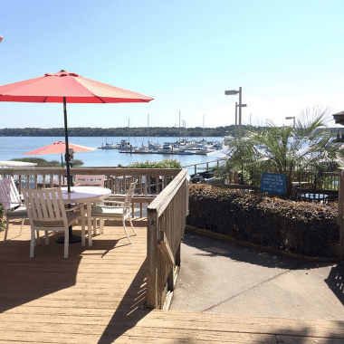
America. They serve what according to many of our repeat customers is the best cheeseburger on the ICW. A menu is included in your welcome package and we hope that you will give it a try. A ten percent discount is available for our visiting boaters. There is usually live entertainment on Friday and Saturday nights. The food is good, the service fair, the beverages cold, and the clientele… well, they are a study in themselves. The Back Porch Grille opens daily at 11:00 AM (opens at 4:00 PM on Mondays) and the food is available until 9:00 PM (or later with notice.) The bar closes around midnight, and it can be an adventure. Stop in and give it a try.
      Thank you for staying with us, best wishes, and safe passage. Please let us know what you have seen along the waterway that we might use to improve your next stay.

      Just a walk or short bike ride away:

      Food & Beverage
      .4 miles………….Hardee’s: breakfast, burgers, sandwiches and fried chicken
      .5 miles………….Agave: Mexican grill (authentic Mexican cuisine)
      .6 miles………….Piggly Wiggly: grocery store
      .6 miles………….ABC Wine & Spirits: beer, liquor and wine
      .45 miles……….Alvin Ord’s: fresh made sandwiches and taco salads, etc.
      .45 miles……….CJ Seafood Express: fresh seafood market (shrimp, fish, crab, etc.)

      Cypress Wetlands Boardwalk

      Cypress Wetlands Boardwalk

      .76 miles……….Mizu Japanese Restaurant: hibachi steakhouse and   sushi
      .7 miles………….Port Royal Farmers Market: local produce and         various fresh foods. Saturdays 8-12pm
      .8 miles………….Pizza Hut: dine in and delivery pizza
      .9 miles………….Carolina Tavern: wings & ribs sports bar
      1.6 miles……….Smokin Planks: family owned and operated BBQ and Smokehouse
      1.6 miles……… 4 Island Pizza: take out & delivery only
      1.9 miles……….La Nopalera Restaurant: Mexican food
      1.1 miles……….Red Rooster Café: breakfast & lunch meals Monday   through Saturday
      1.7 miles……….11th Street Dockside Seafood Restaurant: overlooking shrimp docks on Port Royal Sound
      1.9 miles……….Moon Doggies Café & Grill: great American food meets Southern hospitality
      1.9 miles……….Athenian Gardens: authentic Greek dishes with American friendly options
      1.9 miles……….City Java: local coffee shop, breakfast & lunch
      2.7 miles……….Publix: grocery store
      2.8 miles……….Rancho Grande restaurant: Mexican food
      2.8 miles……….Island Meat Market: Family owned market with full selection of prime cut meats
      2.8 miles……….Bill’s Liquor: great selection of craft beer, premium liquor and fine wines
      Medical Care & PharmacyOld Spanish Fort Beaufort, SC
      .4 miles.………..CVS Pharmacy
      .4 miles………….Doctor’s Care Medical Facility
      .8 miles………….US Naval Hospital
      1.7 miles………..Keyserling Cancer Center
      1.85 miles………Dentists & Family Doctors, etc.
      1.9 miles………..Beaufort Memorial Hospital
      Other Businesses & Services
      .4 miles…………Citgo Service Station
      .4 miles…………Advance Auto Parts
      .5 miles…………Ferguson Enterprises: plumbing, bath, kitchen & lighting
      .6 miles…………West Marine
      .6 miles…………MCAS Credit Union & ATM
      .6 miles………..Music Cooperative: Instrument sales, service and lessons
      .75 miles………CAPA’s Closet: thrift store benefiting abused children and child abuse prevention
      1 mile…………..Roy’s Aquarium: pets & supplies
      2.8 miles………Grayco Hardware & Home: family owned hardware and home goods store

      Thank you for staying with us, best wishes, and safe passage. Please let us know what you have seen along the waterway that we might use to improve your next stay.

      CLICK HERE for a feature on Pat Conroy’s 69ft yacht, The Prince of Tides

      Click Here To View the South Carolina Cruisers’ Net Marina Directory Listing For Port Royal Landing Marina

      Click Here To Open A Chart View Window, Zoomed To the Location of Port Royal Landing Marina

      Be the first to comment!

    • Another !! Update on Ladys Island Swing Bridge, AICW Statute Mile 536


      On May 6, we posted this Update on the Ladys Island Swing Schedule, /?p=148206, in which the new restrictions applied M-F only. Today we received another update from our good friend, Mike Ahart of Waterway Guide, that increases the restrictions to seven days a week.

      The temporary deviation for Ladies Island Swing Bridge in Beaufort SC does apply on weekends and holidays, to the consternation of the bridge tenders and all the sailboaters waiting hours for a bridge opening on a Sunday morning!

      I had talked to the tenders when the new schedule started, and they said, despite the notice, that it would not apply to weekends/holidays…well, I guess they were “corrected.” Another strange thing is that the notice applies to all vessels, including commercial. The bridge tenders raised a stink about that, since the tugs and barges are on schedule and cannot stop ‘“ so, apparently, the Coast Guard is allowing the bridge to open on signal for tugs and barges, despite never changing or issuing a notice to reflect this (at least not one I have managed to find).

      BTW: On CruisersForum.com, someone cited a posting at SSECN from 2010…but also pointed to the current bridge listing.

      MikeA
      Mike Ahart, News Editor, Waterway Guide
      804-313-0274
      www.waterwayguide.com

      Click Here To View the Cruisers’ Net’s South Carolina Bridge Directory Listing For Ladys Island Bridge

      Click Here To Open A Chart View Window, Zoomed To the Location of Ladys Island Bridge

      Comments from Cruisers (1)

      1. Miami -  May 25, 2015 - 11:59 am

        We are sitting at Beaufort waiting for a 9am opening on Sunday morning since 6 this morning. Three boats have called for an opening.
        This is criminal and we must email. call do what ever we can to stop this insanity.
        There is no way to make Charleston in one day or come the other way.
        Please write all SC relevant politicians, Beaufort officialdom and the CG!
        Thanks

        Reply to Miami

    Social Media Auto Publish Powered By : XYZScripts.com