The issue of excessive speed and wake in this narrow, crowded portion of the Waterway has been an issue for several years, see 2017 AICW Speed Zone on public meetings held in Jupiter.
With the 2019 hurricane season underway, this is additional information for boaters navigating the waters of South Florida. This notice comes to us from our good friend, Specialist Erica Skolte, US Army Corp of Engineers.
For Immediate Release, August 26, 2018 Corps prepares for tropical activity; issues guidance to boaters & campers With the possibility of tropical activity in south Florida in the coming days, the U.S. Army Corps of Engineers, Jacksonville District is preparing to respond as needed and providing information to boaters and campers on operational adjustments that will take place at navigation locks and recreation facilities. The Jacksonville District activated its emergency operations center (EOC) at noon today (Aug. 26). This action allows district staff to devote added attention to the response actions that might be necessary should a tropical cyclone or heavy rain develop. “Our staff is coordinating with state and local officials,” said Candida Bronson, Acting Operations Division Chief for Jacksonville District. “We will staff our EOC over the weekend, and dispatch liaison officers to the state EOC and other locations as appropriate.”
Jacksonville District is issuing the following guidance on its operations in south Florida: • For boaters, the Corps plans to extend operating hours for its navigation locks when a storm is 72 hours out. The extended hours will remain in place until a storm is eight hours from landfall. To ensure safety of lock operators, the Corps will suspend operations when lightning is in the area, or when winds exceed 35 mph. • For campers and visitors to recreation sites, Jacksonville District park rangers will monitor conditions at Corps’ campgrounds and recreation areas. If a county government issues an evacuation order for mobile homes or RV parks in an area where there is a Corps’ campground or recreational facility, rangers will order an evacuation of the facility and advise on shelter locations. Visitors should move all campers, motor homes, tents, vessels, and trailers from facilities under evacuation orders. • Field staff will conduct pre-storm evaluation of the Herbert Hoover Dike surrounding Lake Okeechobee. Significant rain on the lake or in the Kissimmee basin to the north could cause a rapid rise in the lake over the coming weeks. The current lake stage is 14.67 feet. While no imminent threat of failure exists, the lake stage is in the upper end of the Corps’ preferred range of 12.5-15.5 feet. More information on Jacksonville District response actions can be found at www.saj.usace.army.mil.
These words of praise by Tom Waid for Westland Marina are not the first we have received, see High Praise. Westland Marina, A CRUISERS NET SPONSOR, is located on the southeastern shore of Titusville’s semi-enclosed harbor.
We recently hauled out at Westland for major work on our Beneteau Oceanis 321. New engine and new rudder. The staff at Westland are friendly, professional, and very accommodating. The boatyard is very tidy compared with other yards I’ve done business with. Jeff and Kyle at Boaters Edge always took time to answer my questions and kept me informed of any delays. (There were “parts in the mail issues.” Not any foot dragging on their part). Kyle did the work of installing the new engine and he did an excellent job. While my wife and I did the work of procuring a new rudder, Kyle did the work of installing it. Again, excellent work.
I highly recommend Westland Marina and Boaters Edge. Tom Waid
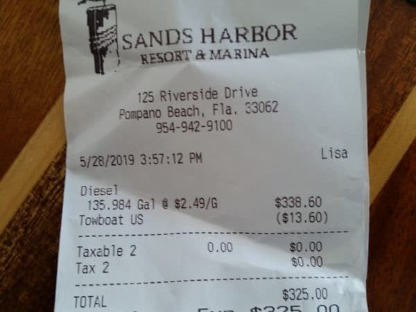
Sands Harbor Resort and Marina is on the east side of the Waterway, just north of the Atlantic Blvd Bridge. Our thanks to Frances Croswell for this money saving notice!
7/12/19 We bought diesel again Tuesday July 8, 2019 at $2.49 at Sands Harbour as previously discussed. I think your recent notice showed this price a/o 7/09 as well. A nice and easy place to fill up! Frances
5/29/19 Fyi, Sands Harbor Marina, Pompano Beach, FL. 954-942-9100 x6000 (North/east side of Atlantic Blvd bridge—Marathon fuel dock–right beside ICW for easy in out)
DIESEL at $2.49 today (local price war) BEFORE you get 10 cent discount for Boat US etc. We just bought last night…copy of receipt attached! A decent overnight stop too. They also have a frequent fueler program (attached). Frances Croswell
The age old issue of converting popular ICW anchorages, such as North and South Lakes in Hollywood, into mooring fields has in the past been associated with municipal waterfronts like St. Augustine. The mooring fields are considered to be a way to prevent derelicts and long term, unattended anchored vessels. See Anchoring Hassels in Hollywood, Florida and Sewage in Waterway Blamed on Boaters, Hollywood, FL.
Stop in and give a big Welcome to one of our newest Sponsors! Only a mile or so upstream from downtown Jacksonville, Ortega Landing Marina, now A CRUISERS NET SPONSOR, is the first facility on your starboard as you enter the Ortega River from the St. Johns. Our thanks to Dave and Nan Fuller for these kind words as posted on AGLCA’s Forum.
We kept our boat for about 18 months at Ortega Landing. We loved both the marina with very nearby conveniences, and Jacksonville itself. It is just past downtown Jacksonville off the St. John’s river about 20 miles or so from the coast on the Ortega River. Tides here are about 18 inches and brackish water. Ortega Landing has floating concrete docks, great amenities, pump outs in slips, and lots of things you want just 3 to 4 blocks away including a Publix, West Marine, several restaurants, and other conveniences. There are several very good repair facilities within a half mile on the river. The only thing missing is covered slips and those are available about 1/4 mile away. Hard to beat this marina and pricing is competitive for this part of Florida. Dave & Nan Ellen Fuller WACI 3
These kind words for CRUISERS NET SPONSOR, Marineland Marina, were posted by Tim Gaffney on AGLCA’s Forum. With many recent facility upgrades and consistently good words from cruisers, Marineland Marina is located in Marineland, FL. See FOCUS ON Marineland Marina for more on this fine facility.
During our adventures we have spent 3-5 months all told at Marineland, 15 miles South of St. Augustine. Marina looks brand new, Dolphins swim inside the cove, 2 free tickets to see the Marineland scientific research center across the street. If memory serves me cost is $1.25 a foot for a monthly stay. I think 30 amp for $35 a month. [See link below for all rates] Eric really watches over the boats! Did I mention the beach is right across the street? Tim Gaffney The Home Office
Ben Matthews is an experienced yachtsman and we are grateful for his sharing of his experience with the numerous engine problems possible with a new previously owned boat. Thankfully, it is a story with a happy ending. Westland Marina, A CRUISERS NET SPONSOR, is located on the southeastern shore of Titusville’s semi-enclosed harbor.
We had mechanical issues in Titusville that needed to be repaired. We recently purchased a (too) lightly used express cruiser we are moving from Florida to North Carolina. In Titusville, the starter on one of the engines failed and was fixed by Boater’s Edge which resides in the same building as Westland Marina. Truly a collaborative arrangement. Westland Marina is under new ownership and they are as nice and accommodating as they can be. I pulled the boat in on a Saturday and made arrangements after hours on their emergency call line, and then contacted Boater’s Edge that Monday. When I picked the boat up the next Friday all the work was done and I pulled out. Fuel issue. Came back. Jeff from Boaters Edge fixed it on the spot. Pulled out again. Circulating pump issue. Pulled in again. They had the part ordered and made arrangements to fix on the spot on Saturday – of Memorial Day Weekend no less – and got me up and on my way by 10am. Superb support and friendliness by Kyle and Jeff to get me back on the water again and headed north. I made 480 miles the next 3 days due to their overtime work and fast response! Also they helped with advice after the repair for my maintenance of it days later. Thanks Guys!
Although Westland Marine and Boater’s Edge are separate businesses, they work collaboratively to help boaters. Sean the nice marina manager has a really friendly Labrador who will play fetch while you wait and the lounge, shower, laundry, and restrooms are spotless and comfortable. Westland is generally a DIY yard and very lively with activity. Many useful stores (grocery, pharmacy, fast food) within a 20-minute walk, and a great ACE Hardware (with marine parts) is a 2 mile Uber/Lyft ride in the Florida heat.
Thanks Westland and B-E for a great experience in a challenging situation! Ben Mathews
Experienced cruisers and frequent Cruisers Net contributors Jim and Peg Healy share their ships log and navigation watches as M/V Sanctuary travels north on the FL/GA Waterway. Thank you Jim and Peg!
Sanctuary and crew stayed last night (5/27) at Amelia Island Yacht Harbor. We departed northbound this morning (5/28/2019) at 06h00 with the tide at Kingsley Creek at +5.1′. We used Bob Shearer’s west side route through the shallows south of Fernandina Beach. That route is fine. We saw no less than 17 ft, so 12 ft at MLW. TowBoatUS is telling people to ignore G”1B” and stay to the east side of the canal, but we had no problems and can’t see why that advice is necessary. Both routes through that shallows appear to be quite viable. Jim and Peg Healy aboard Sanctuary Monk 36 Hull #132
For our tall-masted friends thinking of exploring the upper St. Johns River, Bruce Phaup kindly reminds us that the Shands Bridge with a fixed vertical clearance of 45ft connects Red Bay and Smith Points just south of Green Cove Springs. Funds have been approved for the replacement of Shands Bridge by the Florida Legislature, see links below. The bridge portion of the project is scheduled for completion in 2030.
The Shands Bridge, just south of Green Cove Springs, has a clearance of 45 feet. The Shands Bridge is the controlling height for the entire navigable extent of the St. John’s River, extending south to Sanford, Florida. Bruce Phaup
Lenny and Meryll’s frustration really isn’t with faded NO WAKE signs, but with the fact that too many boaters are not being good neighbors in this very crowded area though downtown Delray Beach. So…SLOW DOWN! With a closed vertical clearance of 27 ft, Linton Blvd bascule bridge crosses the Waterway at Statute Mile 1041.
The NO WAKE signs on the Intracoastal North of the Linton Blvd bridge in Delray Beach are faded and mostly ineffective. There is only one and it can barely be seen. Would you know who I could contact about this? Thanks SO much!! Lenny and Meryll
Palm Coast Marina, one of our newest CRUISERS NET SPONSORS, is located just west of the Intracoastal Waterway at Statute Mile 803 between St. Augustine and Daytona Beach. Our thanks to David Grimes for these kind words.
Our thanks to Tom Hale for his insight on this troublesome area south of Fernandina. See NAV ALERT of April 14th.
For some reason the section between STM 717 and STM 719 is confusing to some. It needn’t be. Northbound after exiting Kinglsey creek you are in the Amelia River. Stay to the east side past R2. The charts show the deepest water on the lower east side. I have used the upper west side at the G2 bend of the river for about 5 years, as the water is deeper along the western shore The eastern channel has at least 8 feet of water at MLLW. The western channel has 12+ at MLLW . This is one place you do not want to follow the NOAA magenta line. It takes you right across the shoal in the middle of the river. At the northern end of either channel you will turn sharply to the east. At this point there are two green ATONs G1 and G1A. As of t4/15/2019, up to date NOAA chart show both G1 and G1A, a steel pole driven firmly into the river bottom with green day boards. As you turn the corner you must follow the south bank of the river. Stay away from R18,16 and 14 as they are marking a shoal. Both the sonar charts and USACE surveys show this south side of the river as the preferred route. Stay along the shore until you are past the paper mill. Then head towards Fernandina Beach Marina.
Southbound is equally simple. Pass Fernandina Beach Marina and then hug the east and south shores past the paper mill. Head west past G1 and G1A to the western side of the river and turn south along the western shore. The attached Sonar Charts give a clear picture of the route. The USACE survey only covers the section north of G1.
Stop in and give a big Welcome to one of our newest Sponsors! Only a mile or so upstream from downtown Jacksonville, Ortega Landing Marina, now A CRUISERS NET SPONSOR, is the first facility on your starboard as you enter the Ortega River from the St. Johns.
Our thanks to author and experienced cruiser Robert Sherer for this report from his Facebook page, Bob423. The reported obstruction appears to be near marker 136 less than a mile north of the Merrill Barber Bridge.
The National Association of State Boating Law Administrators and the Florida Fish and Wildlife Conservation Commission (FWC) encourage all boaters to take a boating safety course.
Palm Coast Marina, one of our newest CRUISERS NET SPONSORS, is located just west of the Intracoastal Waterway at Statute Mile 803 between St. Augustine and Daytona Beach.
We are located just off the Intracoastal Waterway Mile Marker 803. Latitude 29* 34.6 N Longitude 81* 11.58 W
One of Florida’s newest cities (officially incorporated 1999), Palm Coast is a Florida paradise – situated on 70 miles of saltwater and freshwater canals and the Intracoastal Waterway and just minutes from pristine Atlantic Ocean beaches. Vibrant lifestyle and the natural environment go hand-in-hand here. The City offers a dozen beautiful parks, 125+ miles of connecting trails and paths for walking/bicycling, abundant fishing and boating, a year-round Running Series, and world-class tennis and golf. Lined with historic oaks, towering pines and indigenous vegetation, Palm Coast’s parks and trails showcase the splendid elegance of the native Florida landscape. Bird-watching is popular at St. Joe Walkway and Linear Park, which are designated as Great Florida Birding & Wildlife Trails, and visitors can spot dolphins and seabirds as they stroll along the Intracoastal.
For your convenience, our marina is open for business 7 days a week, from 7:00am until 5:00pm.
So, next time you’re on the East Coast, cruise in and experience our peaceful surroundings, frequent wildlife sightings, convenient location, & professional staff and see for yourself why Palm Coast Marina has been the destination of genuine cruisers for over 32 YEARS!
The Palm Coast Marina, located at the mouth of the Palm Coast saltwater canal system, has 80 slips, a ship’s store, and a brand-new fueling station. Mobile repair services and detailing are available, and there is even on-site kayak rentals and yacht brokerage!
Volume fuel discounts are available! We are the only fuel stop between St. Augustine and Daytona Beach. We offer private showers, on-site laundry, and even a boater’s lounge!
Palm Coast, located in Flagler County, is an oceanfront community with a hometown feeling that respects and protects the natural environment – where the sun shines abundantly and people love to get outdoors year-round for fresh air, exercise and family fun!
Living in a healthy environment is important to us. Since our early days, Palm Coast has been carefully designed for a healthy balance between nature and development. We value trees, waterways and beautiful, natural landscaping that give our community a “wow” factor. You’ll find native Florida foliage and colorful birds and wildlife along magnificent trails, along with pristine beaches, world-class golf and tennis and plentiful boating and fishing.
We are conveniently located less than 40 minutes from Daytona Beach International Airport and approximately 1.5 hours from the Orlando International Airport.
Ocean access can be had from St. Augustine (approx. 25 miles north) and Ponce Inlet (approx. 40 miles south). Access can also be made from Matanzas’s Inlet (approx. 10-15 miles north of Palm Coast) depending on boat size and tidal conditions.
St. Augustine Inlet
Ponce Inlet
Matanzas Inlet
Our marina is conveniently located within walking distance to multiple restaurants, bars, shopping, parks and even the Palm Coast Community Center, which offers (often free!) classes and events for children, teens, and adults.
The European Village is a ten minute walk from the marina and is a one stop-destination for all things dining, lounging, shopping, and entertainment – featuring 6 restaurants, 6 shops, 5 bars, and 2 cafes! Also, you don’t want to miss your chance to stock up on fresh produce, breads, tea, honey and more at their weekly Farmer’s Market.
Linear Park, located less than two miles from the marina, is a 57-acre property featuring many amenities for all to enjoy, including a playground, picnic pavilions, hiking and biking trails, shuffleboard, bocce ball and bird watching. The park has been designated as a Great Florida Birding Trail by the Audubon Society for its vast diversity of bird species numbering at times over 40.
Care to play a round of golf? Palm Harbor Golf Club is located a short 1.2 miles away and offers a full service practice facility with a driving range, putting green, & chipping green complete with newly renovated bunker. The pro shop carries both men’s and women’s name brand apparel and equipment.
Other nearby amenities include:
ATM/Bank:
offsite; 2.50 miles
Post Office:
offsite; 2.50 miles
FedEx / UPS:
offsite; 2.50 miles
Dry Cleaner:
offsite; 2.50 miles
Grocery:
offsite; 2.50 miles
Restaurant:
offsite; 0.25 miles
Shopping:
offsite; 2.50 miles
Liquor store:
offsite; 2.50 miles
Pharmacy:
offsite; 2.50 miles
Marine Store:
onsite
Hardware:
offsite; 3.00 miles
Motel:
offsite; 0.10 miles
Airport:
offsite; 30.00 miles
Car Rental:
offsite; 3.00 miles
Hospital:
offsite; 1.00 miles
Doctor:
offsite; 2.50 miles
Dentist:
offsite; 2.50 miles
Veterinarian:
offsite; 2.50 miles
Beach:
offsite; 3.50 miles
Fitness Center:
offsite; 2.50 miles
Golf:
offsite; 1.00 miles
Our dock services include:
A brand new FULL SERVICE FUEL STATION WITH Valv-Tect DIESEL & Valv-Tect NON-ETHANOL GAS, fuel available at transient slips for added convenience
Pump Out
After Hours Docking Assistance
Trash pick-up and disposal
Dock Carts
Professional, on-site Marine Mechanics and Boat Detailing
For your communication needs, we provide:
Free High-Speed Wi-Fi
On-site General Mailbox
Mail Pick-up
Mail & Package Hold
Phone Messages
Fax
Fedex & UPS
Palm Coast Marina is proud to be recognized as a Clean Marina by the Florida Department of Environmental Protection!
Our thanks to Looper Dave Fuller for allowing us to share his excellent report on the AICW/St. Johns River Intersection as posted on AGLCA’s Forum.
As others have reported, this area has been dredged and a new channel was cut for safe passage. The problem is that the old legacy markers G5, G7, and R6 are still on station and the Coast Guard has not updated their charts to show placement of the new ICW markers G7 and G5. The charts do show the new channel however.
A survey was taken back in November 2018 that shows the shoaling area very well. See pic below labeled “1 Survey”. Note that the individual who posted the survey to the Waterway Guide Nav Alert also took a path similar to Alex, south and west of the shoaling area. Obviously you can be successful this way, but this is not the new channel. Also note in the pic that old G7 and R6 do a great job of marking the south side of shoal while G5 marks the north side of shoal. Using these old markers will guarantee a grounding.
The new channel is EAST and North of the shoaling area. I personally have taken this route, EAST and North of the shoaling two times with no issues.
I found a pic in the Coast Guard Notice to Mariners that shows the new route as well as the placement of the new G7 and G5 markers. See pic labeled “2 Dredged Route” I added a red circle to mark the shoaling, circled the new G7 and G5 in green, and added a magenta line on top of the dredged route.
I also included a pic of my Navionics chart that I run on the I-Pad. Note pic “3 Navionics” it shows the new G7 and G5, well East and North of the shoaling.
We will go thru here again in two weeks and will update if we find any new info.
Suggestion: This is a good place to lay down a route line on your chart the night before and follow your route crumb line as you transverse the area. Claudia & Dave Fuller aboard Still Waters II 1981 Viking 43′
Let’s hope you never find yourself in the position of having to prove your vessel seaworthy. Obviously, these “input” meetings have more to do with restricting anchoring than with derelicts. See Anchoring Legislation.
Notice of Public Meeting
The Florida Fish and Wildlife Conservation Commission (FWC), Division of Law Enforcement, will be holding meetings to seek the input of the public in the process of rulemaking. Per direction of the Florida Legislature, FWC will be seeking public input on developing the process that law enforcement officers use to determine that a vessel has an effective means of propulsion for safe navigation. This rule will allow a law enforcement officer to conduct an evaluation of a vessels propulsion capabilities to determine whether or not the vessel is at risk of becoming derelict. This evaluation process will be part of s 327.4107, F.S., through incorporation by rule.
Please see the dates and times scheduled for these public meetings below:
March 11, 2019 Pinellas County Commission Chambers 6:00pm 8:00pm 315 Court Street, Clearwater, Florida 33756
March 12, 2019 St. Augustine City Commission Chambers 6:00pm 8:00pm 75 King Street, St. Augustine, Florida 32085
March 14, 2019 Pensacola City Council Chambers 11:00am 1:00pm 222 W. Main Street, Pensacola, Florida 32502
April 2, 2019 Bernstein Park Meeting Facility 6:00pm 8:00pm 6751 5th Street, Stock Island, Key West, Florida 33040
April 3, 2019 Murray Nelson Government Center 6:00pm 8:00pm 102050 Overseas Highway, Key Largo, Florida 33037
April 4, 2019 Palm Beach County Vista Center, Rooms E-58/E-59 6:00pm 8:00pm 2300 North Jog Road, West Palm Beach, Florida 33411
Among our readers there must be several who are experienced in cruising the AICW in a vessel this size. If so, please let us hear from you. Maybe Chief Officer Perks will take you along as Pilot!
Good morning,
I am currently trying to find any information I can about cruising in Northern Florida. We are a 151ft vessel with a 8ft draft. We would like to cruise the Jacksonville, St Augustine and Cape Canaveral areas. Is there anyone you recommend for me to talk with about the ICW routes and Marinas that could accommodate us?
Thanks in advance,
Andrew Perks Chief Officer – Motor Yacht Time for Us
Share:
0 Facebook Likes, 1 Facebook Reactions
Comments from Cruisers (2)
james- March 12, 2019 - 7:59 pm
Hope you have good anchors. Just plan on staying near the inlets, any venture up or down the ICW from Jax or St Aug would be most difficult with your draft. Plenty of dockage for you in downtown Jax on the St Johns, but watch the currents since it rips thru downtown on the outgoing tide. Call ahead in St Aug for assistance with the inlet as it shoals as fast as they move the buoys. Port Canaveral is your best shot, no current, extremely safe inlet and once into the Indian River you will have deep ICW north and south for at least 20 miles, but no marinas outside Port Canaveral that will accommodate your size (both length and mass) pushing on their docks.
With an 8 foot draft , parts of the ICW can only be safely run at high tide. After leaving Haulover as you arrive at Daytona, do not take any of the side channels. Just before Matanzas, make sure you hug the GREEN side of the channel. Recommend taking bridge of lions at the start of an incoming tide. You will be pushed to the west side of the bridge during transit.
I’ve pushed 200’ barges on the route with a 7 foot draft so it’s doable with care


Be the first to comment!