Visit Logged
  • Select Region
    • All Regions
    • VA to NC Line
    • North Carolina
    • South Carolina
    • Georgia
    • Eastern Florida
    • Western Florida
    • Florida Keys
    • Okeechobee Waterway
    • Northern Gulf
    • Bahamas
    • New York
    • Ohio
    • Pennsylvania
    • Washington
    • Puerto Rico
    • Minnesota
    • Maryland
    Order by:
    • USCG: Sector Charleston Prepares for Upcoming Hurricane Season

      See also Hurricane and Severe Weather Preparation.


      SECTOR CHARLESTON

      UPCOMING 2021 ATLANTIC HURRICANE SEASON

      The Atlantic Hurricane Season will begin June 1, 2021 and will run through November 30, 2021. During this timeframe, the assigned port condition (PORTCON) will remain PORTCON IV and the port status will remain OPEN for all ports and waterways within the Sector Charleston Captain of the Port Zone. These waters are identified in 33 CFR 3.35-15 and lie between the intersection of the North Carolina – South Carolina boarder and the northern bank of the Savannah River.

      In the event of forecasted tropical storm force winds (sustained winds of 34 kts/39 mph or greater) from a tropical cyclone, the Sector Charleston Captain of the Port (COTP) will coordinate with the Heavy Weather Advisory Group (HWAG) to evaluate port preparation and changes in port condition.

      The HWAG consists of maritime transportation system professionals local to the Sector Charleston Captain of the Port Zones, providing input on local operations and coordination for overall port well-being in response to severe weather events.

      The COTP will announce changes to port conditions via a Marine Safety Information Bulletin (MSIB) and a Broadcast Notice to Mariners when forecasted tropical storm force winds (sustained winds of 34 kts/39 mph or greater) from a tropical cyclone threaten South Carolina. These port conditions are as follows:

      Forecasted Hours Prior to Tropical Storm  Force WindsPort ConditionMeasures in Effect
      1 DEC – 31 MAYVGeneral. Port status is OPEN.
      1 JUN – 30 NOVIVHurricane seasonal alert. Industry to review heavy weather plans. Port status is OPEN.
      72WHISKEYThe COTP will assess lay-up and mooring plans, meet with stakeholders, and conduct port assessments. Port status is OPEN.
      48X-RAYThe COTP will finalize review of lay-up and mooring plans, hold further meetings with stakeholders, and continue port assessments. Port Status is OPEN.
      24YANKEEThe COTP may restrict vessel movements, including stopping inbound vessel traffic, and cargo operations. Port status is OPEN with RESTRICTIONS.
      12ZULUThe COTP may restrict all vessel movements, including stopping inbound and outbound vessel traffic, and cargo operations. Port status is CLOSED.
      AFTER

      STORM PASSAGE

      OPEN or OPEN with RESTRICTIONSPrior to authorizing vessel movements and cargo operations, the COTP will conduct a risk analysis based on actual weather observed and port assessments, which may include verifications of aids to navigation, channel hazards, waterfront facility damage, and vessel accountability.

      Very Respectfully,

      LT Chad Ray

      USCG Sector Charleston

      Waterways Management Div., Chief

      (843) 323-7761


      All vessels, waterfront facilities, and marinas should review their heavy weather plans now. Please take into account that drawbridges may not open for vessel traffic when sustained wind speeds reach 25 mph or during land evacuations. Vessels or oceangoing barges greater than 500 gross tons that are unable to go to sea are required to submit heavy weather plans to the COTP. The request form can be obtained from Sector Charleston’s HOMEPORT internal site at https://homeport.uscg.mil/port-directory/charleston. All requests should be submitted to D07-PF-SECTORCHASN-WWM@uscg.mil. The COTP will carefully evaluate vessels requesting to remain in port. Submission alone of a Remain in Port Request does not grant approval from the COTP.


      Currently, and running to May 31, 2021, the threat of severe weather is decreased. PORTCON V with a port status of OPEN remains in effect. This, however, does not prevent the COTP from changing port conditions in the event of forecasted severe weather.

      For HWAG or waterway specific questions, please contact (843) 323-7761. For facility and foreign vessel specific questions, please contact (843) 740-3186. For domestic vessel specific questions, please contact (843) 754-2076. For Coast Guard related emergencies, please contact Sector Charleston Command Center at (843) 740-7050.


      This MSIB can be viewed at https://homeport.uscg.mil/port-directory/charleston.

      Attachments area

      Be the first to comment!

    • LNM: Dredging Underway at Hatteras Inlet, NC

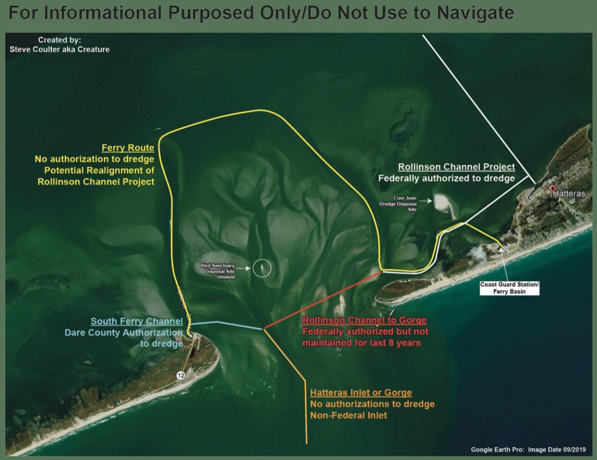
      After numerous complications with dredging the South Ferry Channel, the Army Corps of Engineers reported to the Dare County Waterways Commission at its Monday meeting that the hopper dredge Murden has finally started work removing the problem shoal.


      The federal authorization status of various areas in Hatteras Inlet, as compiled by Waterways Commission Chair Steve “Creature” Coulter.

      Dredging Underway at Hatteras Inlet
      Coastal Review Online

      Be the first to comment!

    • NAV ALERT: LNM: OWW MM 39, Port Mayaca Lock Width Restriction due to Mechanical Failure


      Port Mayaca lies west of Stuart, FL at Statute Mile 39. There is no estimate for the completion of repairs. Stayed tuned for updates. Our thanks to Specialist Erica Skolte for this notice.


      OKEECHOBEE WATERWAY PORT MAYACA LOCK AND DAM 25-FT WIDTH RESTRICTION

      REFERENCE:
      a.     33 CFR Navigation and Navigable Waters
      1. Notice to Navigation

      Notice is given that the Port Mayaca Lock & Dam currently has a 25-foot width restriction due to a mechanical failure of Sector Gate #1. Maintenance crews are onsite doing repair work but currently have no estimated time of completion.

      1. Contact Information
          Edwin Marshall, Supervisor, Okeechobee Waterway East, 863-398-9363.

       //signed//
      Gary L. Hipkins
      Chief Navigation & Flood Risk Management
      South Florida Operations

      Contact

      Erica Skolte
      561-801-5734 (cell)
      Erica.A.Skolte@usace.army.mil

      Be the first to comment!

    • LNM: OWW: Blue Green Algae Alert, Lake Okeechobee, FL

      Vessels navigating the Okeechobee Waterway may encounter potentially toxic Blue Green Algae. Stay out of the water and avoid breathing fumes. If you see the blue-green algae, please send us photos for posting. Thanks!

      Lake Okeechobee Waterway Algae Notice

      REFERENCE:
      a.     33 CFR Navigation and Navigable Waters

      1. Notice to Navigation

      Based on information provided by the Florida Department of Environmental Protection and the Florida Department of Health, the U.S. Army Corps of Engineers advises the public, marinas, and those operating commercial and recreational vessels through the Okeechobee Waterway that there is the potential of encountering Blue Green Algae. According to the Florida Department of Health, visitors should be aware that water from areas with blue-green algae can make animals and people sick, and they should stay away from these areas. This algae may be blue, bright green, brown or red, and can have a strong odor like rotting plants. People who are very sensitive to smells may have respiratory irritation. If you come into contact with blue-green algae, get out of the area and wash off with soap and water. See your doctor if you think blue-green algae has made you sick.

      The following precautions should be taken if you see algae:

      • Do not swim at this location.
      • Avoid getting water in your eyes, nose or mouth.
      • Do not eat shellfish from affected area.
      • Rinse fish fillets with tap or bottled water. Throw out the guts. Cook fish well.
      • Keep pets and livestock away from affected location.

      For Information about algal blooms, visit:

      1. Contact Information

      For up-to-date Lock information contact the shift operator 7 a.m. to 5 p.m. at:

      St. Lucie Lock & Dam 772-287-2665 or 863-662-9148

      Port Mayaca Lock & Dam 561-924-2858 or 863-662-9424

      Moore Haven Lock & Dam 863-946-0414 or 863-662-9533

      Ortona Lock & Dam 863-675-0616 or 863- 662-9846

      WP Franklin Lock & Dam 239-694-5451 or 863-662-9908

      Canaveral Lock 321-783-5421 or 863-662-0298 (6 a.m. to 9:30 p.m.)

      U.S. Army Corps of Engineers Point of Contact is Mr. Gary Hipkins at Gary.L.Hipkins@usace.army.mil or 863-983-8101.

      //signed//
      Gary L. Hipkins
      Chief Navigation & Flood Risk Management
      South
       Florida Operations

      Contact

      Erica Skolte
      561-801-5734 (cell)
      Erica.A.Skolte@usace.army.mil

      Be the first to comment!

    • LNM: Fifth District Maritime Safety Information Upgrade

      Mariners may visit the NAVCEN website and subscribe for email delivery of BNMs.


      NJ – PA – DE – MD – DC – VA – NC – US COAST GUARD 5TH DISTRICT BROADCAST NOTICE TO MARINERS

      The U.S. Coast Guard Navigation Center (NAVCEN) has completed its Maritime Safety Information (MSI) project upgrade to offer Broadcast Notice to Mariners (BNM) to mariners via email in addition to voice radio broadcasts. The online subscription service is in addition to the standard BNM broadcasts over VHF radio that previously, were the only way to receive this vital navigational information. Mariners can now use the subscription service to plan for underway periods and receive updates to Aids to Navigation and navigational hazards in near real time without having to wait on scheduled VHF broadcasts.
      Mariners may visit the NAVCEN website and subscribe for email delivery of BNMs. https://www.navcen.uscg.gov/?pageName=feeds. BNMs are organized by Coast Guard Sector and mariners can subscribe to one, or more Fifth District Sectors. It is also recommended that you subscribe to the “5th Coast Guard District (dpw)” BNMs and the “Atlantic Hazardous Weather Outlook”. Additionally, NAVCEN has developed an online, filterable, BNM archive that is available to the public. 5th District BNMs can be viewed and downloaded from this database on the NAVCEN website at: https://www.navcen.uscg.gov/bnmmessages/DistrictSearchV1.php?d=5&i=4html. For any questions regarding these services contact the NIS Watch at 703-313-5900. LNM 13/21

      Be the first to comment!

    • LNM: USACE: OWW MM 78, Moore Haven Lock 25 Ft. Width Restriction CANCELLED


      Our thanks to Specialist Erica Skolte for this local notice. Notice has been CANCELLED.


      Notice to Navigation 2021-006: Moore Haven Lock 25 Ft. Width Restriction

      OKEECHOBEE WATERWAY
      MOORE HAVEN LOCK
      25 FT WIDTH RESTRICTION

      REFERENCE:
      a.     33 CFR Navigation and Navigable Waters
      1. Notice to Navigation

      The Moore Haven Lock and Dam will have a width restriction of 25 feet until further notice. Crews are currently assessing the situation. No estimated time of repair currently available. The South Florida Operations Office advises all vessels to monitor the Jacksonville District website for any changes or updates. The point of contact is Bill Keeney. He can be reached at 863-368-9086.
      /signed/
      Gary L. Hipkins
      Chief Navigation
      South Florida Operations

      Contact

      Erica Skolte
      561-801-5734 (cell)
      Erica.A.Skolte@usace.army.mil

      Public Affairs Specialist

      Corporate Communications Office

      U.S. Army Corps of Engineers, Jacksonville District Palm Beach Gardens

      OFFICE PHONE 561-340-1527

      Cell:  561-801-5734

      erica.a.skolte@usace.army.mil

      Twitter @JaxStrong

      Jacksonville District Facebook:

      https://www.facebook.com/JacksonvilleDistrict

      Jacksonville District: A team of professionals making tomorrow better “Keep Calm and Essayons”

      Click Here To View the VA to NC Cruisers’ Net Marina Directory Listing For Moore Haven Lock

      Click Here To Open A Chart View Window, Zoomed To the Location of Moore Haven

      Be the first to comment!

    • LNM: Cancellation of NOAA Paper and Raster Nautical Charts

      NOAA has begun to implement its sunset plan for paper nautical charts this month. See NOAA Begins Transition to All Electronic Charts.

      Cancellation of NOAA Paper and Raster Nautical Charts
      The National Oceanic and Atmospheric Administration (NOAA) is undertaking a multi-year program to end production and maintenance of its suite of over 1,000 traditional paper nautical charts and all associated raster chart products and services, including: Print-on-Demand (POD) paper nautical charts, Full-size chart PDF files, BookletChart™ PDF files, NOAA raster navigational charts (NOAA RNC®), the NOAA RNC tile service, and
      the online RNC viewer.
      Six months notice of the intent to cancel a specific chart is provided in a “Last Edition” notice. The final cancellation of a chart is made in a “Canceled” notice. Both types of notices will appear in LNM Section IV, “Chart Correction.” A comprehensive list of all canceled NOAA charts is available at: http://www.charts.noaa.gov/MCD/Dole.shtml.
      Traditional paper nautical chart production is ending to enable the creation and maintenance of larger scale, more up-to-date, higher quality coverage of NOAA’s electronic navigational chart (NOAA ENC®) product. This will significantly enhance the amount of charted detail available to mariners. More information about NOAA’s program to sunset traditional paper charts is on the NOAA Coast Survey website at:
      https://www.nauticalcharts.noaa.gov/farewell-to-traditional-nautical-charts.html
      An online NOAA Custom Chart application at: https://devgis.charttools.noaa.gov/pod is available to create chart images from ENC data, which may then be printed. Notices to Mariners will not be issued for NOAA Custom Charts.
      LNM 9/21

      Be the first to comment!

    • LNM: USACE: Apalachicola-Chattahoochee and Flint River System Update, Northern Gulf, FL

      The USACE has declared 7ft depth channel levels in this Northern Gulf river system.


      FL – AL – GA – APALACHICOLA – CHATTAHOOCHEE AND FLINT (ACF) RIVER SYSTEM – UPDATE

      Based on the 10-day forecast for releases from Jim Woodruff Lock and Dam and subsequent forecasted stage at Blountstown gage, the USACE is continuing to support a 7-foot navigation channel. 
      Additionally, the forecast for the area calls for normal rainfall for the next 3 months. The composite storage graphic, which is updated weekly, can be viewed at the following website:
      http://water.sam.usace.army.mil/ACFconstorage.pdf
      A 7.4-foot Blountstown stage is needed to provide a 7-foot channel on the Apalachicola River. River stages for the ACF system can be viewed at:
      http://water.sam.usace.army.mil/forecast_acf_plots.htm
      Commercial mariners should schedule lockage appointments at the Jim Woodruff Lock by calling (850) 663-4692 or (229) 723-3482. George W. Andrews and Walter F. George Locks remain closed due to mechanical failures. ACF Navigation Bulletins will continue to be issued on a monthly and as needed basis throughout the navigation season. Mariners can direct any questions to Ashley Kleinschrodt, at (251) 694-3726. LNM 6/21

      Be the first to comment!

    • NAV ALERT: LNM: AICW MM 280, Extreme Shoaling, Mason Inlet Intersection, NC


      This shoaling between these ICW buoys appears to be in the mouth of the Waterway’s intersection with Mason Inlet. Mid to high tide is recommended for passage in this intersection where shoaling and shifting channels are SOP.


      Mariners are advised that shoaling exists in the Atlantic Intracoastal Waterway in the vicinity of Mason Inlet Crossing between buoys 121 and 122A, to a depth of less than two feet at mean low water. Mariners are advised to use extreme caution while navigating this area.

      Be the first to comment!

    • LNM: Right Whales Sighted near Outer Banks, NC

      For our offshore mariners! 10 knots or less!


      RIGHT WHALE NAVIGATIONAL WARNING

      NOAA HAS ANNOUNCED A DYNAMIC MANAGEMENT AREA ESTABLISHED FOR AN AGGREGATION OF NORTH ATLANTIC RIGHT WHALES SIGHTED NEAR OUTER BANKS, NORTH CAROLINA

      MARINERS ARE REQUESTED TO ROUTE AROUND OR TRANSIT AT 10 KNOTS OR
      LESS THROUGH THE FOLLOWING AREA.

      OUTER BANKS, NC AREA ACTIVE THROUGH 20 JAN 2021.  NORTHERN BOUNDARY 35-38N, SOUTHERN BOUNDARY 34-57N, EASTERN BOUNDARY 074-48W, WESTERN BOUNDARY 75-35W.
      2.

      Be the first to comment!

    • LNM: Cape Canaveral Launch Activity


      For our offshore cruising friends and inshore spectators.

      ATLANTIC OCEAN – FLORIDA – CAPE CANAVERAL: Rocket Launch Activity
      Mariners making plans to transit offshore Cape Canaveral Florida are advised of frequent rocket launch activity and associated launch hazard areas which may include free falling debris and/or descending vehicles or vehicle components under various means of control. Mariners should contact Coast Guard Sector Jacksonville at (904) 714-7558 for more information. Specific launch schedule information and Marine Safety Information Bulletins (MSIB) can be found at the following website https://homeport.uscg.mil/port-directory/jacksonville. Upcoming launch information and Launch Hazard Areas are also posted on the following Patrick Air Force Base website
      https://www.patrick.af.mil/ or by calling 1-800-470-7232.

      Be the first to comment!

    • LNM: Oregon Inlet ATONs Adjusted, Pamlico Sound, NC


      As the first inlet into NC waters south of the Chesapeake, Oregon Inlet is very tempting to offshore cruisers. HOWEVER, Oregon Inlet is notorious for shoaling, keeping the USCG busy relocating ATONs. Even with this dredging project, Cruisers Net still recommends attempting navigation ONLY with shoal draft and good local knowledge.


      1. DUE TO SHOALING IN OREGON INLET, MANY OF THE PHYSICAL AIDS TO NAVIGATION ARE NOT MARKING BEST WATER AND ARE PRODUCING A MISLEADING SIGNAL.
        2. THE FOLLOWING TEMPORARY AIS SIGNALS HAVE HAS BEEN ESTABLISHED TO MARK BEST WATER.
        A. OREGON INLET SAFE WATER MARK OI ESTABLISHED IN APPROX POSITION 35- 48-44.225(35°0.0000N / 048°44.2250W, 35.000000 / -48.737083) N, 075-31-49.840W, AIS MMSI # 993672418.
        B. OREGON INLET PORT HAND MARK 1 ESTABLISHED IN APPROX POSITION 35-48-23.331N 075-31-44.111W (35°48.3889N / 075°31.7352W, 35.806481 / -75.528920), AIS MMSI # 993672598.
        C. OREGON INLET STARBOARD HAND MARK 2 ESTABLISHED IN APPROX POSITION 35-48-23.500N 075-31- (35°48.3917N / 075°31.0000W, 35.806528 / -75.516667) 56.074W, AIS MMSI # 99367298.
        D. OREGON INLET PORT HAND MARK 3 ESTABLISHED IN APPROX POSITION 35-48-01.428N 075-31-48.155W (35°48.0238N / 075°31.8026W, 35.800397 / -75.530043), AIS MMSI # 993672553.
        E. OREGON INLET STARBOARD HAND MARK 4 ESTABLISHED IN APPROX POSITION 35-48-02.944N 075-31(35°48.0491N / 075°31.0000W, 35.800818 / -75.516667) ‘-56.411W, AIS MMSI # 993672597.
        F. OREGON INLET STARBOARD HAND MARK 6A ESTABLISHED IN APPROX POSITION 35-47-41.508N, 075-31-56.268W (35°47.6918N / 075°31.9378W, 35.794863 / -75.532297), AIS MMSI # 993672595.
        G. OREGON INLET STARBOARD HAND MARK 8 ESTABLISHED IN APPROX POSITION 35-47-21.157N, 075-31-49.228W (35°47.3526N / 075°31.8205W, 35.789210 / -75.530341), AIS MMSI # 993672466.
        H. OREGON INLET PORT HAND MARK 9 ESTABLISHED IN APPROX POSITION 35-47-22.877N, 075-31-45.000W (35°47.3813N / 075°31.7500W, 35.789688 / -75.529167), AIS MMSI # 993672496.


      Be the first to comment!

    • LNM: Shoaling and Channel Shifts, Matanzas Pass, Fort Myers Beach, FL


      This dogleg inlet channel has been an area of shoaling and shifting channels for years. Keep a sharp on your depth finder as you enter. See photo below.


      FLORIDA – FORT MYERS TO CHARLOTTE HARBOR AND WIGGINS PASS – MATANZAS PASS CHANNEL: Shoaling and changes to channel.

      Shoaling has been reported in the vicinity of the newly placed federal aids to navigation at Matanzas Pass at the previous position of Matanzas Pass Daybeacon 4 (LLNR 18095 [26°27.9340N / 081°58.1690W, 26.465566 / -81.969484]), in position 26-27-55.397n, 081-58-09.010w. Mariners are advised that recent dredge work has been completed returning the federal channel back to its original dimensions south of the current route. The channel runs close abeam of the southern beach at Bodwitch Point and is marked with a Temporary buoy 4. Additionally a temporary danger shoal light has been placed in position 26-27-58.002N, 081-58-09.943(26°27.9667N / 081°58.1657W, 26.466112 / -81.969429), flashing quick white at night with a white and orange danger board. This location was previously the position of Matanzas Pass Light 5 (LLNR 18107 [26°27.9664N / 081°58.1654W, 26.466106 / -81.969424]). All mariners are advised to be aware of these hazards to navigation and transit the area with caution.

      Be the first to comment!

    • LNM: Significant Shoaling, Teaches Hole Channel, Ocracoke, Pamlico Sound, NC


      This shoaling is approaching from the northwest at the entrance into Teaches Hole Channel to Ocracoke. The ATONs in this area have a confusing sequence: on entering Teaches Hole from the Inlet,  R 20 should be taken to Port and R 8 across the entrance should be taken to Starboard, i.e. treat R 20 as Green.

      united states coast guard

      HAZARD TO NAVIGATION - THERE HAS BEEN A REPORT OF SHOALING AT TEACHES HOLE CHANNEL.
      
      SHOALING 1-3 FT BETWEEN TEACHES HOLE CHANNEL LIGHTED BUOY 20 (LLNR 28955 [35°4.2756N / 076°1.2614W, 35.071260 / -76.021023]) AND TEACHES HOLE CHANNEL BUOY 23 (LLNR 28961 [35°4.6789N / 076°0.8396W, 35.077982 / -76.013993]). 
      
      ALL MARINERS ARE REQUESTED TO USE CAUTION WHEN TRANSITING THE AREA.

      Be the first to comment!

    • LNM: Cancellation of Paper and Raster Charts

      This local notice describes the phasing out process of printed charts.


      NOAA – CANCELLATION OF PAPER AND RASTER NAUTICAL CHARTS
      Six months before a chart is canceled, NOAA will update the chart with a note in the lower left corner stating the chart’s status as a “last edition” and the date on which it will be cancelled. NOAA will also update the Lists of Latest Chart Editions on www.nauticalcharts.noaa.gov to indicate that the last edition of the chart has been
      published. In the webpage version, “LAST EDITION” will be added before the chart title, and “(Chart will be canceled on MM/DD/YY)” will appear on the next line. When the chart is canceled six months later, the chart number will be removed from its position in the list of active charts and added to the cumulative list of all canceled charts (since 2018) that is appended to the end of the list of active charts. In addition to the paper Print on Demand version of the chart being canceled, all associated raster products will be removed from the NOAA website, including Raster Navigational Charts (NOAA RNC®), Full-size and Booklet Chart™ PDFs, and RNC Tile Service images. A full-size JPEG image of the canceled chart (suitable for framing, but not for navigation) will always be available to download from the NOAA Historical Maps & Charts website, as are most older chart editions. For more information or questions, contact Ryan Wartick at ryan.wartick@noaa.gov.

      Be the first to comment!

    • LNM: USCG Urges Safe Boating with Children

      Boating with young children presents challenges that require mariners to approach a day out on the water with the proper safety plans in place to prevent loss of life, personal injury and property damage.

      News Release 

      U.S. Coast Guard 7th District Southeast
      Contact: 7th District Public Affairs
      Office: 305-415-6683
      After Hours: 305-202-3735
      7th District online newsroom

      Coast Guard urges safe boating with children

      LIFE JACKET

      MIAMI­­­­­­­­­­ – In the United States, drowning is the most common cause of death in children ages 1 to 4. Throughout December, Coast Guard Seventh District crews are highlighting the importance of child safety and the precautions mariners must take when boating with minors.

      Boating with young children presents challenges that require mariners to approach a day out on the water with the proper safety plans in place to prevent loss of life, personal injury and property damage.

      The Coast Guard is advising the public of these safety tips when boating with children:

      • Wear a U.S. Coast Guard approved life jacket when boating. All mariners should follow state laws when it comes to wearing life jackets. When boating with children make sure to choose a life jacket that is appropriate for your child’s weight and water activity.
      • Enroll children into swimming lessons as soon as possible. Drowning is the leading cause of accidental death for children of all ages according to Coast Guard 2019 Statistics. Having the ability to swim serves as a critical line of defense against drowning accidents.
      • Pack all safety equipment prior to getting underway. Ensure that all emergency gear is up to date and stowed in a position that is easily accessible if needed. Equipment such as first aid kits, flares, blankets, radios, and a portable fire extinguisher all play pivotal roles in a scenario that requires quick response to an emergency.
      • Educating children on propeller safety and staying clear of the “props”. Operating below the water line, the propeller is not readily visible to the operator, passengers, and swimmers. It is important to teach children not to fear the propeller, but the important safety rules that pertain to it.
      • Be a good role model. Set a good example and show children that safety is important. Establish basic safety rules so children have instruction on how to act in accordance with safety guidelines.

      To follow our December outreach, follow @USCGSoutheast on Facebook/Twitter for more info. Media interested in an interview please call 305-202-3735.

      For more breaking news follow us on Twitter and Facebook.

      -USCG-


       GovDelivery logo

      Be the first to comment!

    • MSIB: USCG Procedures for Off-Season Severe Weather – Sector Charleston

      In the event of forecasted severe weather between Dec 1, 2020 and May 31, 2021, the COTP will coordinate with the Heavy Weather Advisory Group (HWAG) to evaluate port preparation and changes in port condition. While these procedures are for the SC coast, they are the same followed in all sectors.

      SECTOR CHARLESTON
      END OF 2020 ATLANTIC HURRICANE SEASON

      The Atlantic Hurricane Season began June 1, 2020 and ran through November 30, 2020. During this timeframe, the threat of severe weather was increased and Port Condition (PORTCON) was set to PORTCON IV.

      From December 1, 2020 through May 31, 2021, the threat of severe weather decreases. PORTCON V with a port status of OPEN for all ports and waterways within the Sector Charleston Captain of the Port (COTP) Zone is now in effect. These waters are identified in 33 CFR 3.35-15 and lie between the intersection of the North Carolina – South Carolina border and the northern bank of the Savannah River.

      While the measures in effect are now general, this does not preclude the COTP from changing port conditions in the event of forecasted severe weather. These port conditions are as follows:

      Forecasted Hours Prior to Tropical Storm Force Winds Port Condition Measures in Effect
      1 DEC – 31 MAY                  Port Condition V                                General. Port status is OPEN.
      1 JUN – 30 NOV                  Port Condition IV                               Hurricane seasonal alert. Industry to review heavy weather plans. Port status is OPEN.
      72 hrs                          Port Condition WHISKEY                  The COTP will assess lay-up and mooring plans, meet with stakeholders, and conduct port assessments. Port status is OPEN.
      48 hrs                          Port Condition X-RAY                            The COTP will finalize review of lay-up and mooring plans, hold further meetings with stakeholders, and continue port assessments. Port Status is OPEN.
      24 hrs                          Port Condition YANKEE                           The COTP may restrict vessel movements, including stopping inbound vessel traffic, and cargo operations. Port status is OPEN with RESTRICTIONS.
      12 hrs                          Port Condition ZULU                             The COTP may restrict all vessel movements, including stopping inbound and outbound vessel traffic, and cargo operations. Port status is CLOSED.
      AFTER STORM PASSAGE     Port is OPEN or OPEN with RESTRICTIONS  Prior to authorizing vessel movements and cargo operations, the COTP will conduct a risk analysis based on actual weather observed and port assessments, which may include verifications of aids to navigation, channel hazards, waterfront facility damage, and vessel accountability.

      In the event of forecasted severe weather, the COTP will coordinate with the Heavy Weather Advisory Group (HWAG) to evaluate port preparation and changes in port condition.

      The HWAG consists of maritime transportation system professionals local to the COTP Port Zones, providing input on local operations and coordination for overall port well-being in response to severe weather events.

      The COTP will announce changes to port conditions via a Marine Safety Information Bulletin (MSIB) and a Broadcast Notice to Mariners when forecasted severe weather threaten South Carolina.

      Vessels, waterfront facilities, and marinas are recommended to take this opportunity of decreased threat of severe weather and evaluate heavy weather plans, anticipated vessel remain-in-port requests, avenues of evacuation, and local contact lists.

      For HWAG or waterway specific questions, please contact (843) 323-7761. For facility and foreign vessel specific questions, please contact (843) 740-3186. For domestic vessel specific questions, please contact (843) 754-2076. For Coast Guard related emergencies, please contact Sector Charleston Command Center at (843) 740-7050.

      This MSIB can be viewed at https://homeport.uscg.mil/port-directory/charleston.


      Be the first to comment!

    • NAV ALERT: LNM: AICW MM 1080, Shoaling Reported, Bakers Haulover, FL


      This shoaling appears to begin just north of Bakers Haulover Inlet. Slow speed and sharp watch are required.

      FLORIDA – AICW – WEST PALM BEACH TO MIAMI – NORTHERN BISCAYNE BAY: Bakers Haulover Shoaling
      Mariners are advised that significant shoaling has been identified in portions of the Intracoastal waterway within Bakers Haulover, in the vicinity of:

      25-54-15.77N / 80-07-49.37W (25°54.2629N / 080°7.8229W, 25.904381 / -80.130381),

      25-53-51.14N / 80-08-01.75W (25°53.8523N / 080°8.0291W, 25.897539 / -80.133819),

      25-53-59.71N / 80-07-33.10W (25°53.9951N / 080°7.5517W, 25.899919 / -80.125861),

      25-54-15.62N / 80-07-44.83W (25°54.2603N / 080°7.7471W, 25.904339 / -80.129119) .
      The shoaling has resulted in depths being reduced below 10 feet in some areas with the most severe portions showing a depth as low as 2.9 feet.
      Extreme caution should be exercised when transiting the area to avoid vessel damage and potential groundings.

      Be the first to comment!

    • LNM: NOAA Discontinues Printed Tide Tables and Tidal Current Tables

      The move to all digital tables and charts has been expected for some time.

      NATIONAL OCEANIC ATMOSPHERIC ADMINISTRATION (NOAA) IS DISCONTINUING THE PRINTED TIDE TABLES AND TIDAL CURRENT TABLES
      NOAA is ending the production of the printed Tide Tables and Tidal Current Tables publications. There will not be NOAA printed Tide Tables and Tidal Current Tables publications for 2021. NOAA is discontinuing the production of these annual publications due to: (a) recent changes by the U.S. Coast Guard in the interpretation of the
      requirements for predictions, no longer requiring these publications in paper format and (b) the availability of online and electronic services providing tide and tidal current predictions which meet the U.S. Coast Guard requirements for navigation, and support other activities along the U.S. Coast.
      Tide and Tidal Current predictions are available through NOAA’s Center for Operational Oceanographic Products and Services (CO-OPS) online services:
      NOAA Tide Predictions: https://tidesandcurrents.noaa.gov/tide_predictions.html
      NOAA Current Predictions: https://tidesandcurrents.noaa.gov/noaacurrents/Regions
      For questions or more information, contact Tide.Predictions@noaa.gov or 301-713-2815 LNM 45/20

      Be the first to comment!


    Social Media Auto Publish Powered By : XYZScripts.com