Visit Logged
  • Select Region
    • All Regions
    • VA to NC Line
    • North Carolina
    • South Carolina
    • Georgia
    • Eastern Florida
    • Western Florida
    • Florida Keys
    • Okeechobee Waterway
    • Northern Gulf
    • Bahamas
    • New York
    • Ohio
    • Pennsylvania
    • Washington
    • Puerto Rico
    • Minnesota
    • Maryland
    Order by:
    • LNM: Safety Zone, Key West Paddle Classic, October 2, 8 a.m. to 3 p.m. Key West, FL

      The 2021 Key West Paddle Classic will be held on October 2, 2021 on the waters surrounding Key West, FL.


      FLORIDA – FLORIDA KEYS – KEY WEST: Key West Paddle Classic and Safety Zone

      1. The 2021 Key West Paddle Classic will be held on October 2, 2021 on the waters surrounding Key West, FL. This event will consist of approximately 200 paddler boarders completing a 12 mile clockwise course starting along the southern shoreline beginning at Higgs Beach, transiting through the main harbor and Fleming Key Cut, around Dredgers Key, through Cow Key Channel and returning to the finish line at Higgs Beach.
      2. A temporary moving safety zone has been established by the Captain of the Port (COTP) Key West, FL for this event. The safety zone encompasses all waters extending 100 yards to either side of the race participants and safety vessels; extending 50 yards in front of the lead safety vessel preceding the first race participants; and extending 50 yards behind the safety vessel trailing the last race participants. The safety zone will be enforced from 8 a.m. until 3 p.m. on October 2, 2021.
      3. During the enforcement period, no person or vessel may enter, transit through, anchor, or remain within the safety zone without permission from the COTP or his designated representative.
      4. A succession of not less than 5 short whistle or horn blasts from a patrol vessel will be the signal for any non-event participating vessel to take immediate steps to avoid collision. Also, the display of a red distress flare from a patrol vessel will be a signal for any and all vessels, including event participants inside the regulated area, to stop immediately.
      5. Mariners are advised to abide by all Navigation Rules and proceed with caution in the vicinity of the course and event participants.
      6. For more information on this event please contact Sector Key West at (305)-292-8727

      Be the first to comment!

    • LNM: AICW MM 576 Dredging, Savannah River/AICW Intersection

      Elba Island Cut is a maintained channel on the Georgia side of Savannah River across from Fields Cut in South Carolina.


      GEORGIA – SAVANNAH RIVER AND WASSAW SOUND – SAVANNAH RIVER/AICW: Dredging operations.

      On or about October 5, 2021 Goodloe Marine will begin dredging operations in the Atlantic Intracoastal Waterway (AICW) at Elba Island Cut just south of the intersection of the AICW and the Savannah River in Georgia. The cutter dredge EXEL will be removing shoal material from the AICW and pumping the material thru a 20” submerged pipeline across the Savannah River to an upland spoil area on the north side of the Savannah River. Mariners are cautioned to pass dredge at an idle speed and be mindful of numerous buoys and floating pipelines in and near the navigation channel. The dredge can be contacted on channel 16 and 68 for passing instructions. Additional information can be obtained by contacting Ben Goodloe 813-355-7494. Dredging operations are expected to be complete by Nov 15, 2021. For further information, please contact the United States Coast Guard at (912) 247-0073. Chart 11512  LNM 39/21

      Be the first to comment!

    • LNM: near AICW MM 270 Shoaling, Old Topsail Creek, New Topsail Inlet, NC


      Old Topsail Creek connects New Topsail Inlet with the Waterway at Mile 270. Buoys 1 and 2 are inshore, on the northeast side of the inlet. LLNRs given below are incorrect.


      THE SHOAL ADJACENT TO OLD TOPSAIL CREEK BUOYS 1(LLNR 30032 [34°20.7287N / 077°39.9956W, 34.345478 / -77.666594]) AND 2 (LLNR
      30033) HAS STARTED TO CLOSE OFF THE ENTERANCE TO THE CREEK. DEPTHS BETWEEN THE
      AIDS WAS OBSERVED TO 5 FT AND BELOW ACROSS THE ENTIRE CHANNEL. ALL MARINERS ARE ADVISED TO TRANSIT WITH EXTREME CAUTION.


      Be the first to comment!

    • LNM: OWW MM 60 Low Cable Restriction Cancelled, Torry Island Swing Bridge, FL


      Cruisers Net has been reporting this problem since 2017, see Low Cable Continues to Restrict.  The notice below is a 2/24/21 LNM on the low cable and that Notice has been cancelled. This USACE cancellation does not make clear if the cable has been raised or removed. Either  way, it is good news for our tall-masted friends. Our thanks to Specialist Erica Skolte for this notice.


      This Notice to Navigation on the Okeechobee Waterway Route 2 has been CANCELLED- there is no restriction to navigation at the Torry Island Swing Bridge.


      Erica Skolte

      Public Affairs Specialist

      Corporate Communications Office

      U.S. Army Corps of Engineers, Jacksonville District Palm Beach Gardens

      Cell:  561-801-5734

      erica.a.skolte@usace.army.mil

      Twitter @JaxStrong

      Jacksonville District Facebook:

      https://www.facebook.com/JacksonvilleDistrict

      Jacksonville District: A team of professionals making tomorrow better “Keep Calm and Essayons”’

      Click Here To View the Okeechobee Cruisers Net Bridge Directory Listing For Torry Island Bridge

      Click Here To Open A Chart View Window, Zoomed To the Location of Torry Island Bridge


      Be the first to comment!

    • LNM: Northern Gulf Offshore Hazards, Panama City and Pensacola, FL

      No specific dates are given for these exercises. Call the number given below if you plan to transit that part of the Gulf.

      Mariners making plans to transit offshore Panama City and Pensacola, Florida, are advised of frequent rocket activity and associated hazardous areas which may include free falling debris and/or descending vehicles or vehicle components under various means of control.
      Offshore Pensacola, bound by the following approximate position:

      29-48-00.0N 087-30-00.0W (29°48.0000N / 087°30.0000W, 29.800000 / -87.500000),
      Offshore Panama City, bound by the following approximate position:

      29-45-57.0N 086-01-48.0W (29°45.9500N / 086°1.8000W, 29.765833 / -86.030000),
      Mariners should contact U.S. Coast Guard Sector Mobile at (251) 441-5976, for more information. Specific scheduled information and Marine Safety Information Bulletins (MSIB) can be found at the following website https://homeport.uscg.mil/port-directory/jacksonville. Upcoming information and Hazardous Areas are also posted on the following Patrick Air Force Base website https://www.patrick.af.mil/ or can be obtained by calling 1 (800) 470 7232

      Be the first to comment!

    • LNM: AICW near MM 844, Jetty Extensions, Ponce De Leon Inlet, FL


      This extension work applies to both north and south jetties. No completion date is included.


      FLORIDA – TOLOMATO RIVER TO PALM SHORES – PONCE DE LEON INLET: Jetty extension

      Kiewit Construction is conducting construction to extend the Ponce De Leon Inlet jetties eastward. Construction equipment will be located on the north side of the jetties, and occasionally on the south side potentially impacting the channel. Mariners are advised to use caution when transiting the area. For waterways related questions, contact Coast Guard Sector Jacksonville Waterways Management Division at (904) 714-7661 or via email at Shawn.R.Keeman@uscg.mil. Chart 11485

      Be the first to comment!

    • LNM: RANSOMWARE – WORLDWIDE

      On July 15, 2021, the U.S. Government launched a new website (StopRansomware.gov) to help organizations reduce their risk from ransomware.


      RANSOMWARE – WORLDWIDE

      On July 15, 2021, the U.S. Government launched a new website (StopRansomware.gov) to help organizations reduce their risk from ransomware. This website provides organizations of all sizes with resources to better protect their networks and highlights the latest ransomware-related alerts from U.S. Government agencies. StopRansonware.gov includes information about the critical steps that should be taken to respond to and recover from a cyber incident. This includes a comprehensive Ransomware Guide and Cyber Hygiene services that are available at no cost to help
      organizations with vulnerability scanning, web application scanning, penetration testing, and phishing assessments. These services can help assess, identify, and reduce exposure to cyber threats like ransomware. For any questions about this new resource, please utilize the Contact Us info at https://go.usa.gov/xFcWx. For more information about U.S. Maritime Alerts and Advisories, including subscription details, please visit https://go.usa.gov/xFcWr.//.

      Be the first to comment!

    • LNM: NOAA: Saildrones to Operate on Seacoast of NC, SC, GA, FL

      These orange 9.5 ft tall, 23ft unmanned surface vessels will have a white, all-round light and radar reflector. Speed is 1.5kts.  NOAA is requesting greater than 500 meters stand-off.


      NC – SC – GA – FL – SEACOAST – UNMANNED SURFACE RESEARCH VEHICLE

      Saildrone, Inc. will be operating uncrewed Surface Vehicles called Saildrones for the purpose of oceanographic and fisheries data collection. Two Saildrones will operate from Jacksonville, FL on July 23rd. Of the two Saildrones deployed from Jacksonville, FL, one will operate in inshore and offshore waters off the coast of North Carolina throughout the summer to approximately November 15, 2021. Chart 11520 LNM 28/21

      Comments from Cruisers (1)

      1. Glenn Holland -  July 19, 2021 - 8:21 am

        Glad to hear this news. I won't even consider picking a race although it would be tempting @ 1.5 kts.
        Catboat driver

        Reply to Glenn
    • MSIB: REMINDER: Post-Storm ATONs May Be Off-Station

      Following the winds and storm surge of Tropical Storm Elsa, some ICW ATONs, particularly temporary markers,  may be off-station. When in doubt, slow down, watch your depth finder and consult local knowledge if available.

      MSIB: Due to potential effects from Tropical Storm ELSA throughout coastal South Carolina, mariners are urged to transit with caution considering the possibility of Aids to Navigation discrepancies or other hazards to navigation. If discovered, please report any of these issues to the United States Coast Guard.   

      Be the first to comment!

    • LNM: USACE: OWW MM 94 Width Restriction, Ortona Lock, FL


      The Ortona Lock and Dam will have a width restriction of 23 feet until further notice. This restriction is due to mechanical failure. Crews are currently assessing the situation. No estimated time of repair currently available. Ortona Lock is located at Okeechobee Waterway Statute Mile 94, just east of unlighted daybeacon #1 and flashing daybeacon #2. Our thanks to Specialist Erica Skolte for this notice.

      Notice to Navigation: Okeechobee Waterway – Ortona Lock width restriction to 23 feet

      Erica Skolte

      Public Affairs Specialist

      Corporate Communications Office

      U.S. Army Corps of Engineers, Jacksonville District Palm Beach Gardens

      OFFICE PHONE 561-340-1527

      Cell:  561-801-5734

      erica.a.skolte@usace.army.mil

      Twitter @JaxStrong

      Jacksonville District Facebook:

      https://www.facebook.com/JacksonvilleDistrict

      Jacksonville District: A team of professionals making tomorrow better “Keep Calm and Essayons”

      Click Here To View the Okeechobee Cruisers Net Bridge Directory Listing For Ortona Lock

      Click Here To Open A Chart View Window, Zoomed To the Location of Ortona Lock


      Be the first to comment!

    • LNM: AICW MM 270-280 Buoys 99, 99A, 121 and 121A Relocated, Middle Sound, NC


      These ICW buoys are on the southeast shoulder of the Waterway south of its intersection with Howards Creek.


      1. THE FOLLOWING AIDS TO NAVIGATION HAVE BEEN RELOCATED TO MARK BEST WATER.


      1. NEW RIVER – CAPE FEAR RIVER BUOY 99 (LLNR 39547 [34°21.5792N / 077°40.3919W, 34.359653 / -77.673199]) HAS BEEN RELOCATED TO POSITION 34-21-34.718N, 077-40-23.369W (34°21.5786N / 077°40.3895W, 34.359644 / -77.673158) .


      1. NEW RIVER – CAPE FEAR RIVER BUOY 99A (LLNR 39548 [34°21.2979N / 077°40.8884W, 34.354965 / -77.681474]) HAS BEEN RELOCATED TO POSITION 34-21-15.729N, 077-40-54.988W (34°21.2621N / 077°40.9165W, 34.354369 / -77.681941) .


      1. NEW RIVER – CAPE FEAR RIVER BUOY 121 (LLNR 39597 [34°15.0071N / 077°46.9064W, 34.250118 / -77.781774]) HAS BEEN RELOCATED TO POSITION 34-14-58.624N, 077-46-56.130W (34°14.9771N / 077°46.9355W, 34.249618 / -77.782258) .


      1. NEW RIVER – CAPE FEAR RIVER BUOY 121A (LLNR 39598 [34°14.9245N / 077°46.9776W, 34.248742 / -77.782960]) HAS BEEN RELOCATED TO POSITION 34-14-56.380N, 077-46.58(34°14.9396N / 077°46.5800W, 34.248994 / -77.776333) -057W.

      Be the first to comment!

    • LNM: Northern Gulf Hazardous Operations Offshore, Tallahassee, Panama City and Pensacola, FL

      No time frame is given for these hazardous operations, so give a call to the numbers below to verify safe transit through these offshore areas.


      FL – GULF OF MEXICO – PANAMA CITY – PENSACOLA – Hazardous Operations

      Mariners making plans to transit offshore Tallahassee, Panama City and Pensacola, Florida, are advised of frequent rocket activity and associated hazardous areas which may include free falling debris and/or descending vehicles or vehicle components under various means of control.
      Offshore Pensacola, bound by the following approximate positions:

      29-55-48.0N 087-38-34.8W (29°55.8000N / 087°38.5800W, 29.930000 / -87.643000),

      29-55-48.0N 087-21-25.2W (29°55.8000N / 087°21.4200W, 29.930000 / -87.357000),

      29-40-12.0N 087-38-34.8W (29°40.2000N / 087°38.5800W, 29.670000 / -87.643000) and

      29-40-12.0N 087-21-25.2W (29°40.2000N / 087°21.4200W, 29.670000 / -87.357000) .
      Offshore Panama City, bound by the following approximate positions:

      29-53-45.6N 086-10-15.6W (29°53.7600N / 086°10.2600W, 29.896000 / -86.171000),

      29-53-45.6N 085-53-06.0W (29°53.7600N / 085°53.1000W, 29.896000 / -85.885000),

      29-38-09.6N 086-10-15.6W (29°38.1600N / 086°10.2600W, 29.636000 / -86.171000) and

      29-38-09.6N 085-53-06.0W (29°38.1600N / 085°53.1000W, 29.636000 / -85.885000) .
      Offshore Tallahassee, bound by the following approximate positions:

      29-22-48.0N 084-20-31.2W (29°22.8000N / 084°20.5200W, 29.380000 / -84.342000),

      29-22-48.0N 084-03-28.8W (29°22.8000N / 084°3.4800W, 29.380000 / -84.058000),

      29-07-12.0N 084-20-31.2W (29°7.2000N / 084°20.5200W, 29.120000 / -84.342000) and

      29-07-12.0N 084-03-28.8W (29°7.2000N / 084°3.4800W, 29.120000 / -84.058000) .
      Mariners should contact U.S. Coast Guard Sector Mobile at (251) 441-5976, for more information. Specific scheduled information and Marine Safety Information Bulletins (MSIB) can be found at the following website https://homeport.uscg.mil/port-directory/jacksonville. Upcoming information and  Hazardous Areas are also posted on the following Patrick Air Force Base website https://www.patrick.af.mil/ or can be obtain by calling 1 (800) 470-7232   Charts 411 11360 11389    LNM 16/21

      Be the first to comment!

    • USCG: Sector Charleston Prepares for Upcoming Hurricane Season

      See also Hurricane and Severe Weather Preparation.


      SECTOR CHARLESTON

      UPCOMING 2021 ATLANTIC HURRICANE SEASON

      The Atlantic Hurricane Season will begin June 1, 2021 and will run through November 30, 2021. During this timeframe, the assigned port condition (PORTCON) will remain PORTCON IV and the port status will remain OPEN for all ports and waterways within the Sector Charleston Captain of the Port Zone. These waters are identified in 33 CFR 3.35-15 and lie between the intersection of the North Carolina – South Carolina boarder and the northern bank of the Savannah River.

      In the event of forecasted tropical storm force winds (sustained winds of 34 kts/39 mph or greater) from a tropical cyclone, the Sector Charleston Captain of the Port (COTP) will coordinate with the Heavy Weather Advisory Group (HWAG) to evaluate port preparation and changes in port condition.

      The HWAG consists of maritime transportation system professionals local to the Sector Charleston Captain of the Port Zones, providing input on local operations and coordination for overall port well-being in response to severe weather events.

      The COTP will announce changes to port conditions via a Marine Safety Information Bulletin (MSIB) and a Broadcast Notice to Mariners when forecasted tropical storm force winds (sustained winds of 34 kts/39 mph or greater) from a tropical cyclone threaten South Carolina. These port conditions are as follows:

      Forecasted Hours Prior to Tropical Storm  Force WindsPort ConditionMeasures in Effect
      1 DEC – 31 MAYVGeneral. Port status is OPEN.
      1 JUN – 30 NOVIVHurricane seasonal alert. Industry to review heavy weather plans. Port status is OPEN.
      72WHISKEYThe COTP will assess lay-up and mooring plans, meet with stakeholders, and conduct port assessments. Port status is OPEN.
      48X-RAYThe COTP will finalize review of lay-up and mooring plans, hold further meetings with stakeholders, and continue port assessments. Port Status is OPEN.
      24YANKEEThe COTP may restrict vessel movements, including stopping inbound vessel traffic, and cargo operations. Port status is OPEN with RESTRICTIONS.
      12ZULUThe COTP may restrict all vessel movements, including stopping inbound and outbound vessel traffic, and cargo operations. Port status is CLOSED.
      AFTER

      STORM PASSAGE

      OPEN or OPEN with RESTRICTIONSPrior to authorizing vessel movements and cargo operations, the COTP will conduct a risk analysis based on actual weather observed and port assessments, which may include verifications of aids to navigation, channel hazards, waterfront facility damage, and vessel accountability.

      Very Respectfully,

      LT Chad Ray

      USCG Sector Charleston

      Waterways Management Div., Chief

      (843) 323-7761


      All vessels, waterfront facilities, and marinas should review their heavy weather plans now. Please take into account that drawbridges may not open for vessel traffic when sustained wind speeds reach 25 mph or during land evacuations. Vessels or oceangoing barges greater than 500 gross tons that are unable to go to sea are required to submit heavy weather plans to the COTP. The request form can be obtained from Sector Charleston’s HOMEPORT internal site at https://homeport.uscg.mil/port-directory/charleston. All requests should be submitted to D07-PF-SECTORCHASN-WWM@uscg.mil. The COTP will carefully evaluate vessels requesting to remain in port. Submission alone of a Remain in Port Request does not grant approval from the COTP.


      Currently, and running to May 31, 2021, the threat of severe weather is decreased. PORTCON V with a port status of OPEN remains in effect. This, however, does not prevent the COTP from changing port conditions in the event of forecasted severe weather.

      For HWAG or waterway specific questions, please contact (843) 323-7761. For facility and foreign vessel specific questions, please contact (843) 740-3186. For domestic vessel specific questions, please contact (843) 754-2076. For Coast Guard related emergencies, please contact Sector Charleston Command Center at (843) 740-7050.


      This MSIB can be viewed at https://homeport.uscg.mil/port-directory/charleston.

      Attachments area

      Be the first to comment!

    • LNM: Dredging Underway at Hatteras Inlet, NC

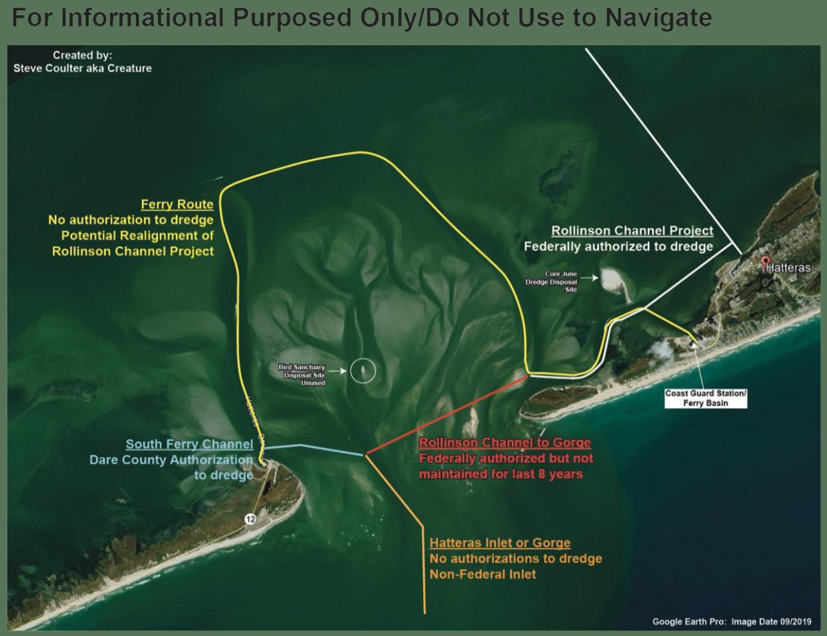
      After numerous complications with dredging the South Ferry Channel, the Army Corps of Engineers reported to the Dare County Waterways Commission at its Monday meeting that the hopper dredge Murden has finally started work removing the problem shoal.


      The federal authorization status of various areas in Hatteras Inlet, as compiled by Waterways Commission Chair Steve “Creature” Coulter.

      Dredging Underway at Hatteras Inlet
      Coastal Review Online

      Be the first to comment!

    • NAV ALERT: LNM: OWW MM 39, Port Mayaca Lock Width Restriction due to Mechanical Failure


      Port Mayaca lies west of Stuart, FL at Statute Mile 39. There is no estimate for the completion of repairs. Stayed tuned for updates. Our thanks to Specialist Erica Skolte for this notice.


      OKEECHOBEE WATERWAY PORT MAYACA LOCK AND DAM 25-FT WIDTH RESTRICTION

      REFERENCE:
      a.     33 CFR Navigation and Navigable Waters
      1. Notice to Navigation

      Notice is given that the Port Mayaca Lock & Dam currently has a 25-foot width restriction due to a mechanical failure of Sector Gate #1. Maintenance crews are onsite doing repair work but currently have no estimated time of completion.

      1. Contact Information
          Edwin Marshall, Supervisor, Okeechobee Waterway East, 863-398-9363.

       //signed//
      Gary L. Hipkins
      Chief Navigation & Flood Risk Management
      South Florida Operations

      Contact

      Erica Skolte
      561-801-5734 (cell)
      Erica.A.Skolte@usace.army.mil

      Be the first to comment!

    • LNM: OWW: Blue Green Algae Alert, Lake Okeechobee, FL

      Vessels navigating the Okeechobee Waterway may encounter potentially toxic Blue Green Algae. Stay out of the water and avoid breathing fumes. If you see the blue-green algae, please send us photos for posting. Thanks!

      Lake Okeechobee Waterway Algae Notice

      REFERENCE:
      a.     33 CFR Navigation and Navigable Waters

      1. Notice to Navigation

      Based on information provided by the Florida Department of Environmental Protection and the Florida Department of Health, the U.S. Army Corps of Engineers advises the public, marinas, and those operating commercial and recreational vessels through the Okeechobee Waterway that there is the potential of encountering Blue Green Algae. According to the Florida Department of Health, visitors should be aware that water from areas with blue-green algae can make animals and people sick, and they should stay away from these areas. This algae may be blue, bright green, brown or red, and can have a strong odor like rotting plants. People who are very sensitive to smells may have respiratory irritation. If you come into contact with blue-green algae, get out of the area and wash off with soap and water. See your doctor if you think blue-green algae has made you sick.

      The following precautions should be taken if you see algae:

      • Do not swim at this location.
      • Avoid getting water in your eyes, nose or mouth.
      • Do not eat shellfish from affected area.
      • Rinse fish fillets with tap or bottled water. Throw out the guts. Cook fish well.
      • Keep pets and livestock away from affected location.

      For Information about algal blooms, visit:

      1. Contact Information

      For up-to-date Lock information contact the shift operator 7 a.m. to 5 p.m. at:

      St. Lucie Lock & Dam 772-287-2665 or 863-662-9148

      Port Mayaca Lock & Dam 561-924-2858 or 863-662-9424

      Moore Haven Lock & Dam 863-946-0414 or 863-662-9533

      Ortona Lock & Dam 863-675-0616 or 863- 662-9846

      WP Franklin Lock & Dam 239-694-5451 or 863-662-9908

      Canaveral Lock 321-783-5421 or 863-662-0298 (6 a.m. to 9:30 p.m.)

      U.S. Army Corps of Engineers Point of Contact is Mr. Gary Hipkins at Gary.L.Hipkins@usace.army.mil or 863-983-8101.

      //signed//
      Gary L. Hipkins
      Chief Navigation & Flood Risk Management
      South
       Florida Operations

      Contact

      Erica Skolte
      561-801-5734 (cell)
      Erica.A.Skolte@usace.army.mil

      Be the first to comment!

    • LNM: Fifth District Maritime Safety Information Upgrade

      Mariners may visit the NAVCEN website and subscribe for email delivery of BNMs.


      NJ – PA – DE – MD – DC – VA – NC – US COAST GUARD 5TH DISTRICT BROADCAST NOTICE TO MARINERS

      The U.S. Coast Guard Navigation Center (NAVCEN) has completed its Maritime Safety Information (MSI) project upgrade to offer Broadcast Notice to Mariners (BNM) to mariners via email in addition to voice radio broadcasts. The online subscription service is in addition to the standard BNM broadcasts over VHF radio that previously, were the only way to receive this vital navigational information. Mariners can now use the subscription service to plan for underway periods and receive updates to Aids to Navigation and navigational hazards in near real time without having to wait on scheduled VHF broadcasts.
      Mariners may visit the NAVCEN website and subscribe for email delivery of BNMs. https://www.navcen.uscg.gov/?pageName=feeds. BNMs are organized by Coast Guard Sector and mariners can subscribe to one, or more Fifth District Sectors. It is also recommended that you subscribe to the “5th Coast Guard District (dpw)” BNMs and the “Atlantic Hazardous Weather Outlook”. Additionally, NAVCEN has developed an online, filterable, BNM archive that is available to the public. 5th District BNMs can be viewed and downloaded from this database on the NAVCEN website at: https://www.navcen.uscg.gov/bnmmessages/DistrictSearchV1.php?d=5&i=4html. For any questions regarding these services contact the NIS Watch at 703-313-5900. LNM 13/21

      Be the first to comment!


    Social Media Auto Publish Powered By : XYZScripts.com