Visit Logged
  • Select Region
    • All Regions
    • VA to NC Line
    • North Carolina
    • South Carolina
    • Georgia
    • Eastern Florida
    • Western Florida
    • Florida Keys
    • Okeechobee Waterway
    • Northern Gulf
    • Bahamas
    • New York
    • Ohio
    • Pennsylvania
    • Washington
    • Puerto Rico
    • Minnesota
    • Maryland
    • Tennessee
    • NW Waters
    Order by:
    • Tampa Bay Region: Brace for a major arctic blast – Fred Pickhardt

      Fred Pickhardt’s Substack is free today. But if you enjoyed this post, you can tell Fred Pickhardt’s Substack that their writing is valuable by pledging a future subscription. You won’t be charged unless they enable payments.


      Forwarded this email? Subscribe here for more

      A powerful arctic cold front will bring a major weather shift to Florida this weekend. Hazardous cold is expected Saturday night through Monday with widespread hard freeze conditions and wind chills potentially dropping to 20 degrees or less in the Tampa Bay area.


      Forecast Summary (Next 3-4 Days)

      • Today (Friday, Jan 30): Expect a brief warming trend with highs reaching the upper 60s to low 70s under mostly sunny skies. Clouds will increase late as a cold front approaches.
      • Saturday (Jan 31): The cold front pushes through, bringing morning showers and a sharp drop in temperatures during the afternoon. It will become extremely blustery with northwest winds of 15–25 mph and gusts exceeding 40 mph.
      • Saturday Night – Sunday (Feb 1): Dangerously cold air arrives. Lows will plummet into the 20s for the Nature Coast and low 30s for Tampa and interior areas. Wind chills could reach the single digits in northern counties and the 20s elsewhere.
      • Monday (Feb 2): Clear and remaining very cold. Record-low temperatures are possible Monday morning before a slow moderation begins mid-week.

      Key Hazards

      • Extreme Cold: Widespread Hard Freeze Warnings and Freeze Warnings are anticipated for Saturday and Sunday nights. Record low maximum temperatures are possible on Sunday as highs struggle to reach the mid-40s.
      • Frozen Precipitation: NWS forecasters mention a low (10–20%) probability of light snow flurries or “Gulf-effect” snow/rain mixtures from Citrus to Hillsborough counties late Saturday night as residual moisture meets freezing air. There is a small risk that some areas could see a light dusting of snow.
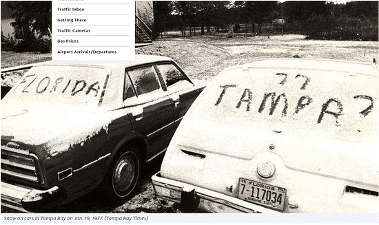
      • Does History Repeat?: On January 19, 1977, the city of Tampa, Florida, experienced a rare and historic weather event when measurable snow fell for the first time in recorded history. While only about 0.2 inches of snow was officially recorded in Tampa, surrounding areas like Plant City received up to 2 inches, and flurries were seen as far south as Miami.


      • Marine & Coastal: A Gale Warning is expected for coastal waters, with gusts potentially reaching storm force. High surf and dangerous rip currents will impact area beaches through the weekend.

      Ocean Weather Services

      Forensic Marine Weather Expert


      You’re currently a free subscriber to Fred Pickhardt’s Substack. For the full experience, upgrade your subscription.

      Upgrade to paid

       
      Like
       
      Comment
       
      Restack


      © 2026 Fred Pickhardt
      548 Market Street PMB 72296, San Francisco, CA 94104
      Unsubscribe

      Start writing

      Be the first to comment!


    Social Media Auto Publish Powered By : XYZScripts.com