We remain in a tranquil weather pattern across the Atlantic tropics for now. We have a disturbance in the Gulf that won’t develop before moving into Louisiana, but will bring some rain to the lower and middle Mississippi Valley this weekend. We also have four tropical waves to track. One is over the Caribbean Sea and Colombia (along 75° west), one is near the Lesser Antilles (at 60° west), and the other two are over the tropical Atlantic (near 53° west and near 27° west).
A loop of visible satellite imagery showing the features of interest across the Atlantic tropics. A storm centered northeast of Bermuda will not turn into a tropical cyclone as it moves eastward across the Atlantic.
Image Source: University of Wisconsin RealEarth
The Madden-Julian Oscillation is favorable for tropical cyclone formation over the Atlantic. However, other factors, such as widespread strong vertical wind shear (blame the developing El Niño in the Pacific for that), make further development in the Atlantic unlikely over the next seven days.
Starting about a week from now, the shear may relax enough over the western Caribbean Sea and Gulf that one of the waves now drifting westward over the tropical Atlantic has a chance to develop further once it reaches the area. It’s also possible that a Central American Gyre forms, and we get a development from that, or that the gyre and a tropical wave come together and spawn a tropical cyclone. Everyone’s favorite computer model, “The Euro”, has jumped on the bandwagon of showing a possible development around mid-month. However, it can only be said at this time that development is a reasonable possibility in a week or so. Until a storm develops or we’re sure one is imminent, we can’t say whether South Carolina will be affected.
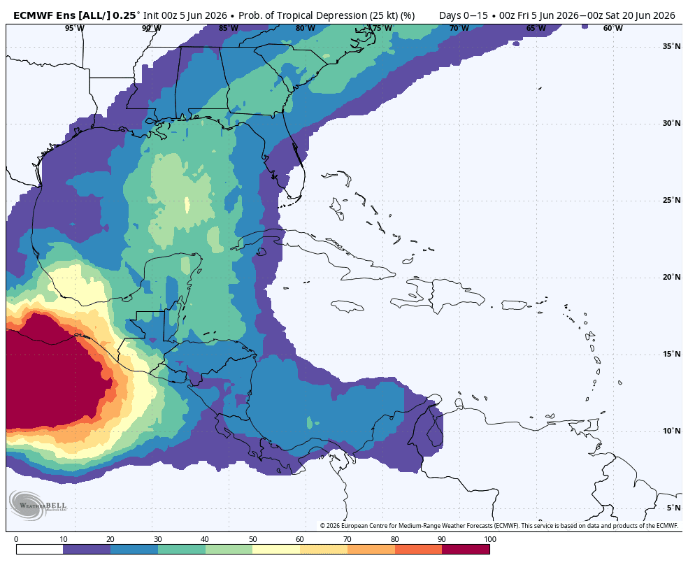
This is output from the ECMWF Ensemble model indicating the percent chance for a tropical cyclone to be within 300 kilometers (about 186 miles) of a point on the map through the 15-day model run (starting at 8 p.m. Thursday EDT). It gives a user an idea of where tropical cyclones could form and track over the next 15 days. It does not indicate how strong a potential storm could be.
Image Source: WeatherBELL
An alternate scenario is that one of the storms we’ll see develop in the far East Pacific might cross Central America into the Atlantic in a week or so. That’s rare but not unheard of.
The bottom line is that you should be sure you’re ready for anything the hurricane season might throw at you. There’s a chance we’ll have to deal with a storm sooner rather than later. So, get those hurricane kits stocked and have your plan ready. As always, your best source for preparedness information is hurricane.sc.
South Carolina weather highlights for the next week:
High pressure currently overhead keeps us warm to hot and rain-free through this weekend. Humidity will increase as the high shifts eastward and the wind becomes southeasterly. Highs will be mainly in the upper 80s to lower 90s on Saturday, then mainly in the low- to-mid 90s on Sunday.
Along comes a ‘backdoor front’ (moving in from the northeast) on Monday, which will likely become stationary over South Carolina into Tuesday. That will generate mainly afternoon and evening showers and thunderstorms, which could be spotty. That will ease the heat somewhat, with highs mainly in the upper 80s to lower 90s on Monday, then mid-to-upper 80s on Tuesday.
The front retreats northward after that, putting us in a hot and humid air mass for the end of next week. Afternoon thunderstorms can’t be ruled out, but will be isolated and mainly confined to the Upstate and Coastal Plain. Highs trend up to the low 90s for most of the state by Thursday.
Early signs suggest it could be quite hot next Friday and next weekend, with some 95°+ temperatures possible for our state’s usual hot spots.
Frank Strait Severe Weather Liaison S.C. State Climate Office
South Carolina Department of Natural Resources 260 D. Epting Lane West Columbia, SC, 29172


Be the first to comment!