


How Bad will El Nino be? – Fred Pickhardt
Fred Pickhardt’s Substack is free today. But if you enjoyed this post, you can tell Fred Pickhardt’s Substack that their writing is valuable by pledging a future subscription. You won’t be charged unless they enable payments.
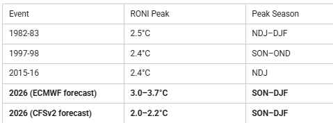
Both the US CFSv2 and the ECMWF ENSO models agree that this El Niño is strengthening rapidly and will likely be a strong-to-very-strong event peaking in fall/winter 2026. The ECMWF is forecasting a peak relative Niño 3.4 anomaly of roughly 3.0–3.7°C, while CFSv2 peaks around 2.0–2.2°C. That’s nearly a full degree difference at the high end, with both models using the same relative index framework. The CFSv2 projection shows signs of a waning El Niño by early 2027, while ECMWF holds near peak conditions. If we average the two models you get a peak of about 2.7 C which would be a very strong El Nino indeed.
Putting this in historical context using RONI:Since February 2026, NOAA’s Climate Prediction Center has used the Relative Oceanic Niño Index (RONI) as its official ENSO metric, replacing the traditional ONI. RONI subtracts the tropical-mean SST anomaly from the Niño 3.4 value and applies a scaling factor, stripping out background warming to isolate true El Niño intensity. The three strongest events in the instrumental record (1950–present):
No event in the historical record has exceeded 2.5°C RONI. ECMWF’s plume implies a serious chance of shattering that ceiling by 0.5–1.2°C, which would be genuinely unprecedented. Even CFSv2’s more conservative projection would place this event among the top three on record, approaching the 1982-83 peak. The 2015-16 event for comparison:The 2015-16 El Niño crossed 1.0°C RONI in June 2015 and accelerated through fall: JAS 1.6 → ASO 1.9 → SON 2.2 → OND 2.3 → NDJ 2.4 (peak). Decay was swift, dropping below zero by May 2016 and plunging into strong La Niña (−1.1°C) by fall. The 1982-83 event followed a nearly identical trajectory, peaking at 2.5°C in NDJ–DJF before collapsing into La Niña by late 1983. Notably, the traditional ONI ranking of these events is different: 2015-16 led at 2.6°C, followed by 1997-98 at 2.3°C, and 1982-83 at 2.2°C. RONI reverses that order, revealing that much of 2015-16’s apparent record strength was inflated by background tropical warming rather than El Niño dynamics alone. What to watch:As we move into late summer, the rate of intensification will tell us which model is closer to reality. If we’re tracking toward ECMWF’s upper range, this will be an event unlike anything in the modern record. If CFSv2 is right, it’s still a major El Niño with significant global weather impacts, but not the record-breaker ECMWF suggests. Forensic Marine Weather Expert
You’re currently a free subscriber to Fred Pickhardt’s Substack. For the full experience, upgrade your subscription. |






Be the first to comment!