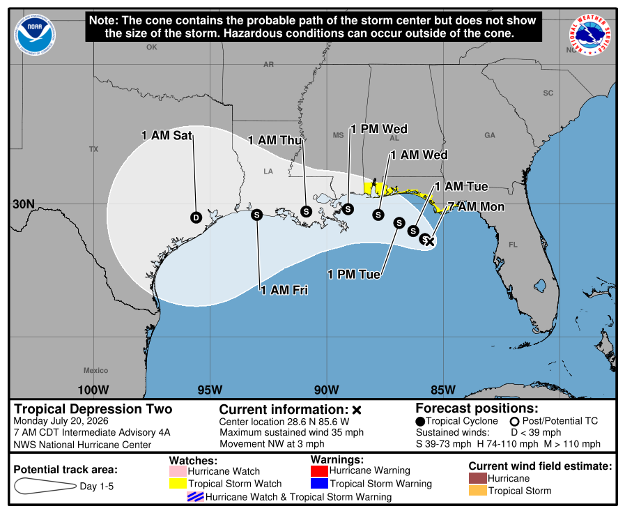
Over the weekend, the disturbance over the eastern Gulf became Tropical Depression Two. It remains a weak feature south of Panama City, Florida.
It now looks like it will head westward instead of our way. The National Hurricane Center calls for it to move into Louisiana Wednesday afternoon as a weak tropical storm. So, it won’t have any effect on us through the first part of the week. Some computer models show moisture from it being pulled toward us later this week by a cold front moving in. That would be nice; we need the rain.
It’s quiet over the rest of the Atlantic still. The tropical wave near Cabo Verde on Friday is now over the middle of the tropical Atlantic along 40° west, but there is little thunderstorm activity with it. Another wave moving off of Africa today will struggle against dry, stable air and vertical wind shear.
The above loop of visible satellite imagery above shows several features of interest across the North Atlantic and eastern U. S.:
Tropical Depression Two over the northeastern Gulf.
A tropical wave near 40° west in the tropical Atlantic
A band of clouds over North Carolina, Virginia, Tennessee, Kentucky and the Atlantic associated with a stationary front.
Smoke from Canadian wildfires is spilling southward over the middle of the Atlantic, all the way into the deep tropics.
Stay prepped; hurricane.sc is the place to go for prep advice.
Our Weather This Week:
The front we hoped would bring us active weather early this week has stalled farther north than expected. It’s close enough that the northern half of the state will see substantial coverage of afternoon thunderstorms through Tuesday, and a locally severe storm with damaging wind is possible. A stray storm can’t be ruled out further south, but they will be isolated. Temperatures will remain near to a few degrees above average.
We remain on track to see a more substantial cold front move through on Wednesday afternoon and evening. With that comes more widespread storms and the risk for locally severe storms, especially across the north. Damaging winds will be the primary concern.
It’s looking more likely that the front will stall over us later in the week now rather than push south. There’s a chance that the Upstate sees a nice day with low humidity on Friday, but don’t count on it. Otherwise, we’ll see limited sunshine with widespread showers and thunderstorms, mostly during the afternoon. If tropical moisture from TD Two becomes involved, torrential downpours and a flash-flooding risk would become a concern.
Frank Strait Severe Weather Liaison S.C. State Climate Office
South Carolina Department of Natural Resources 260 D. Epting Lane West Columbia, SC, 29172







Be the first to comment!