Good morning. It’s been a minute since I had to do one of these on a day other than Friday! The situation I mentioned this past Friday is evolving faster than I expected. A low-pressure area is forming southeast of the mouth of the Rio Grande, with thunderstorms clustered around it. It looks like a tropical depression or storm is forming.
The above loop of visible satellite imagery shows an area of low pressure forming over the southwestern Gulf that likely becomes a tropical depression or storm soon.
Image Source: University of Wisconsin RealEarth
The National Hurricane Center gives it a 90% chance of becoming a tropical cyclone over the next two days. It’s safe to say they’re planning to deal with a storm soon. The next name on this year’s list is Isaias.
Will we in South Carolina have a storm to deal with? The confidence level is lower, but probably not. Our computer models suggest this developing storm will drift eastward at first, then turn north and hit the central Gulf Coast. An eastward turn looks likely well after landfall, but probably after passing by to our west.
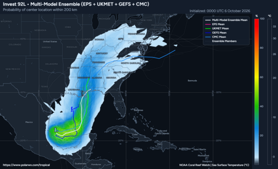
This plot from PolarWx.com shows the density of tropical cyclone tracks from four computer model ensembles run by NOAA, the ECMWF, Environment Canada, and the United Kingdom Met Office. The plot shows a strong model consensus on the developing storm tracking toward the central Gulf Coast.
However, a stationary front, the one that brought heavy rain to parts of the state this past weekend, sits between us and the developing storm. It will retreat northward in front of the storm and pass through South Carolina over the weekend. A surge of tropical moisture will come with it, so that the front could bring some or all of the state heavy rain and even isolated flooding. Saturday night into Sunday looks to be the time of greatest concern.
The Weather Prediction Center’s Day 5 Excessive Rainfall Outlook graphic for South Carolina shows the flooding risk Saturday and Saturday night.
If the storm takes a substantially more eastward track (odds look low for this, but not zero), we could see a windy period Sunday, with an even greater risk of heavy rainfall, along with a risk of isolated tornadoes and coastal flooding around high tide.
Of course, since the storm hasn’t formed yet, there is a lot of uncertainty. We’ll have to monitor the station closely. Be sure your storm preps are in place and visit hurricane.sc if you need prep advice.
Frank Strait Severe Weather Liaison S.C. State Climate Office









Be the first to comment!