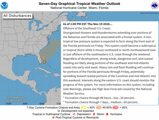
A storm forming over or near The Bahamas on Friday into Friday night will track northward to northeastward through Saturday, potentially becoming strong and tracking close enough to South Carolina to bring strong winds, heavy rain, coastal flooding, rough surf and beach erosion to eastern parts of the state.
However, there are a wide range of possibilities, and the storm may track too far to the east or be too weak to cause damaging winds and flooding.
Timing of these impacts looks to be Saturday afternoon and night, perhaps into Sunday morning.
The main area of concern will be the southern Pee Dee and Grand Strand, though some or all of Charleston and Berkeley Counties could see those impacts as well.
I was hoping I could tell y’all today exactly what will happen over the weekend with the developing coastal storm, but that’s not how it’s going. The computer models are still producing widely varying ideas about what might happen. They have trended the potential track a bit east, which helps us, but that’s really the only thing that has changed since Wednesday. We still have a wide range of possibilities. The National Hurricane Center remains concerned that it becomes a tropical or subtropical cyclone.
However, the impacts will be the same whether or not it has a name. The storm will likely form over or near The Bahamas on Friday and move north or northeast, affecting South Carolina starting Saturday and moving away early Sunday, perhaps before daybreak.
If the storm is strong enough and passes close enough to our coast, we’ll see strong winds, heavy rain (mostly beneficial, but too much rain too fast can lead to flash flooding), and coastal flooding at high tide. There would also be rough surf and beach erosion along our coast, with the Grand Strand seeing the worst of it.
The main area of concern is the southern Pee Dee region and the Grand Strand, which have the best chance of seeing damaging winds of 50 mph or higher. There’s a chance the stronger winds and heavier rain impacts Charleston and Berkeley County as well. Areas to the west won’t be at risk for damaging winds and flooding unless the storm is much farther west than forecast and also an intense storm, which appears unreasonable right now. Also, the risks for the eastern part of the state won’t materialize if the storm tracks farther east or underperforms in intensity.
We remain in a ‘prepare for the worst, hope for the best’ situation over the eastern part of the state. So, make sure you have what you need to deal with a storm we hope won’t be too impactful, but could be. Make sure your storm prep is in order, and visit hurricane.sc if you need prep advice.
Frank Strait Severe Weather Liaison S.C. State Climate Office










Be the first to comment!