CRUISERS NET
Cruisers Helping Cruisers
Comprehensive cruising resource for the Intracoastal Waterways
from Norfolk to the Northern Gulf and Bahamas.
from Norfolk to the Northern Gulf and Bahamas.
FREE to use due to the generosity of our sponsors - please patronize them
East Coast Major Storm Update – Fred Pickhardt
Fred Pickhardt’s Substack is free today. But if you enjoyed this post, you can tell Fred Pickhardt’s Substack that their writing is valuable by pledging a future subscription. You won’t be charged unless they enable payments.
 Forwarded this email? Subscribe here for more
East Coast Major Storm Update
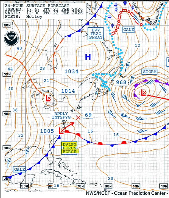
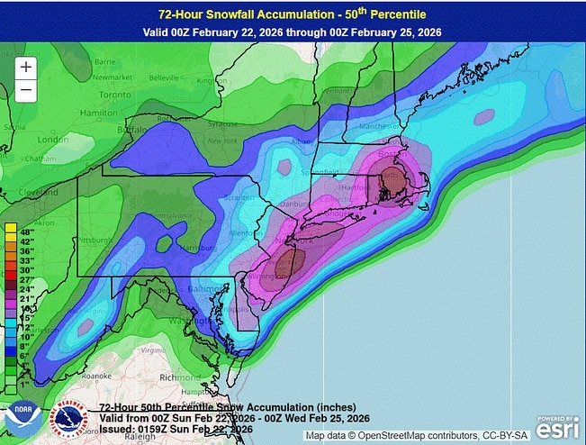
A major winter storm is forecast to impact the Mid-Atlantic and Northeast from Sunday, February 22, through Monday, February 23, 2026.


A powerful nor’easter is expected to produce widespread snowfall of 1 to 2 feet (12–24 inches) and blizzard conditions along coastal areas, resulting in nearly impossible travel and potential for numerous power outages.
Key Weather Hazards
- Blizzard Conditions: Millions of residents from coastal Delaware through southeastern New England are under blizzard warnings. High winds combined with heavy snow will cause whiteout conditions and near-zero visibility.
- Extreme Winds: Wind gusts are expected to range from 40 to 70 mph from coastal New Jersey to southeast New England.
- Power Outages: The combination of strong winds and the weight of heavy, wet snow is likely to cause scattered to numerous power outages.
- Coastal Flooding: Moderate to major coastal flooding and high surf are forecast, with inundation of roads and property most likely from Delaware to Cape Cod.
Travel and Safety Impacts
Travel will become treacherous to life-threatening starting Sunday afternoon. Officials have urged residents in major metropolitan areas, including New York City, to stay off the roads. Significant disruptions to travel and infrastructure are likely, including widespread flight cancellations and school closures on Monday.
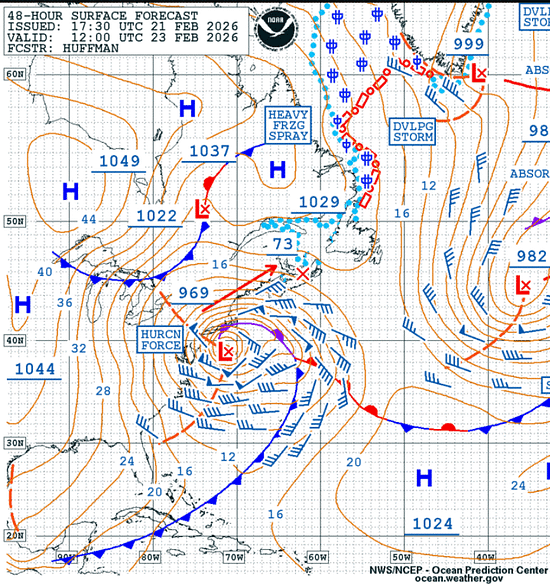
Offshore Waters
Storm to Hurricane force winds and seas building up to 9-11 meters within 180-360 nm south of the center during the next 36-48 hours.
NOAA US Coastal Waters Forecasts
NOAA Weather Prediction Center
You’re currently a free subscriber to Fred Pickhardt’s Substack. For the full experience, upgrade your subscription.
© 2026 Fred Pickhardt
548 Market Street PMB 72296, San Francisco, CA 94104
Unsubscribe

Be the first to comment!
- Blizzard Conditions: Millions of residents from coastal Delaware through southeastern New England are under blizzard warnings. High winds combined with heavy snow will cause whiteout conditions and near-zero visibility.
March Cruising Weather in the Gulf & Caribbean – Fred Pickhardt
Fred Pickhardt’s Substack is free today. But if you enjoyed this post, you can tell Fred Pickhardt’s Substack that their writing is valuable by pledging a future subscription. You won’t be charged unless they enable payments.
Forwarded this email? Subscribe here for moreMarch is one of the most popular months for cruising the Gulf of Mexico and the Caribbean—and for good reason. It sits right at the sweet spot between winter cold fronts and the start of the wetter summer pattern. For cruisers, that means comfortable temperatures, manageable seas, and very low risk of tropical weather…

Continue reading this post for free in the Substack app
Like
Comment
Restack
© 2026 Fred Pickhardt
548 Market Street PMB 72296, San Francisco, CA 94104Be the first to comment!
Hurricane Force Wind Warning: West Atlantic – Fred Pickhardt
Fred Pickhardt’s Substack is free today. But if you enjoyed this post, you can tell Fred Pickhardt’s Substack that their writing is valuable by pledging a future subscription. You won’t be charged unless they enable payments.
Forwarded this email? Subscribe here for more
A 1000 mb low at 36N 72W is moving NE at 25 knots with winds up to 45 knots and 5-meter seas. Within the next 30 hours the storm center will intensify significantly, with central pressure dropping to 966 mb. Winds will reach 55 to 70 knots with seas building 8 to 13 meters (approx. 26 to 43 feet) within 180 nm south of the low center.

You’re currently a free subscriber to Fred Pickhardt’s Substack.
Be the first to comment!
Florida Boaters Now Have Access to Free State-Approved Online Boating Safety Course – BoatUS

BoatUS is the leading advocate for boating safety in the US and A CRUISERS NET SPONSOR.
Press Contact:
Alisha Sheth, BoatUS PR Manager
Florida Boaters Can Now Take Free
State-Approved Boating Safety CourseAt-home learning helps Florida boaters prepare for the water easily and conveniently
FORT LAUDERDALE, Fla. – February 4, 2026 – The BoatUS Foundation for Boating Safety and Clean Water has launched the only free interactive boating safety course for Florida recreational boaters.
The course, which is approved by the Florida Fish and Wildlife Conservation Commission and meets state boating safety education requirements, can be taken at the student’s own pace. After passing the exam, they can print their own certificate of completion for immediate use and will receive a lifetime card from the Florida Fish and Wildlife Conservation Commission.
The course provides video demonstrations and sample common boating situations for students to interact with to better understand how to evaluate real-world instances. The learning experience includes storylines where the student “boats” to various places and includes interactive learning tools like flashcards and drag-and-drop features to enhance learning and retention. Course-takers will be able to design and name the virtual boat that takes them through the course and map how far they’ve “traveled” within it.
In the state of Florida, anyone born on or after January 1, 1988, who operates a vessel powered by 10 horsepower or more must pass an approved boating safety course and have in his/her possession photographic identification and proof of boating safety education
completion issued by the Florida Fish and Wildlife Conservation Commission. The online BoatUS Foundation boating safety course and exam are approved by the National Association of State Boating Law Administrators (NASBLA) and recognized by the U.S. Coast Guard as exceeding the minimum requirements for the National Recreational Boating Safety Program.
“NASBLA approval of our Florida Boating Safety Course is a meaningful investment in boater safety, said Lynne O’Hearn, Program Manager at BoatUS Foundation. “Boater education is one of the most effective ways to prevent accidents, and this course gives Florida boaters the opportunity to build their skills to better enjoy Florida waterways safely.”
To take the course, visit BoatUS.org/Florida. For more information about Florida boating safety education, visit myfwc.com/boating/
safety-education. About BoatUS Foundation for Boating Safety and Clean Water:
The BoatUS Foundation for Boating Safety and Clean Water is a national leader promoting safe, clean and responsible boating. Funded primarily by donations from the more than 740,000 members of Boat Owners Association of The United States (BoatUS), the nonprofit provides innovative educational outreach directly to boaters and anglers with the aim of reducing accidents and fatalities, increasing stewardship of America’s waterways, and keeping boating safe for all. A range of safe and clean boating courses – including the nation’s only free online boating safety course – can be found at BoatUS.org/Courses.
The views expressed in this media release are solely those of the sender and do not necessarily reflect the views of Cision.
You are receiving this email because you were included on Geico (Government Employees Insurance Company)’s media release. To unsubscribe and stop receiving emails from this organization click here.
Be the first to comment!
Severe Weather Risk For Southeast Update – Fred Pickhardt
Fred Pickhardt’s Substack is free today. But if you enjoyed this post, you can tell Fred Pickhardt’s Substack that their writing is valuable by pledging a future subscription. You won’t be charged unless they enable payments.
Forwarded this email? Subscribe here for more
There is a risk for severe weather across the Southeast through Sunday due to severe thunderstorms with potentially damaging gusty winds and a few possible tornadoes, particularly across northern Florida and Georgia, including the adjacent coastal waters.

There is a 5 to 15% risk for wind gusts in thunderstorms to exceed 50 knots producing Hazardous sea conditions over the coastal waters of parts of Florida and Georgia.
You’re currently a free subscriber to Fred Pickhardt’s Substack. For the full experience, upgrade your subscription.
© 2026 Fred Pickhardt
548 Market Street PMB 72296, San Francisco, CA 94104
Unsubscribe

Be the first to comment!
Storm Update: Marine Severe Weather Risk – Fred Pickhardt
Fred Pickhardt’s Substack is free today. But if you enjoyed this post, you can tell Fred Pickhardt’s Substack that their writing is valuable by pledging a future subscription. You won’t be charged unless they enable payments.
Forwarded this email? Subscribe here for more
A strong storm system is making its way across the South and East, bringing a threat of severe weather and localized flooding through Monday morning. For Saturday and Sunday, February 14-15th, the Storm Prediction Center indicates a 5-15% risk of severe thunderstorms capable of producing wind gusts of 50 knots or higher for the adjacent marine areas of the Gulf and portions of the coastal waters of Georgia and northern Florida.


Be the first to comment!
Severe Weather Threat to West-Central Gulf Coastal Waters – Fred Pickhardt
Fred Pickhardt’s Substack is free today. But if you enjoyed this post, you can tell Fred Pickhardt’s Substack that their writing is valuable by pledging a future subscription. You won’t be charged unless they enable payments.
Forwarded this email? Subscribe here for moreSevere weather is expected to impact the Southern U.S. from Saturday, February 14 (Valentine’s Day) into early Sunday morning. A potent storm system moving from the Southern Plains toward the Mississippi Valley will trigger multiple hazards across the region.

There will be at least a 15% probability of damaging thunderstorm winds or wind gusts of 50 knots or higher in the coastal waters of northeastern Texas to the coast of central Louisiana.

Be the first to comment!
Florida Boaters Now Have Access to Free State-Approved Online Boating Safety Course – BoatUS Foundation
BoatUS is the leading advocate for boating safety in the US and A CRUISERS NET SPONSOR.
Press Contact:
Alisha Sheth, BoatUS PR Manager
Florida Boaters Can Now Take Free
State-Approved Boating Safety CourseAt-home learning helps Florida boaters prepare for the water easily and conveniently
FORT LAUDERDALE, Fla. – February 4, 2026 – The BoatUS Foundation for Boating Safety and Clean Water has launched the only free interactive boating safety course for Florida recreational boaters.
The course, which is approved by the Florida Fish and Wildlife Conservation Commission and meets state boating safety education requirements, can be taken at the student’s own pace. After passing the exam, they can print their own certificate of completion for immediate use and will receive a lifetime card from the Florida Fish and Wildlife Conservation Commission.
The course provides video demonstrations and sample common boating situations for students to interact with to better understand how to evaluate real-world instances. The learning experience includes storylines where the student “boats” to various places and includes interactive learning tools like flashcards and drag-and-drop features to enhance learning and retention. Course-takers will be able to design and name the virtual boat that takes them through the course and map how far they’ve “traveled” within it.
In the state of Florida, anyone born on or after January 1, 1988, who operates a vessel powered by 10 horsepower or more must pass an approved boating safety course and have in his/her possession photographic identification and proof of boating safety education
completion issued by the Florida Fish and Wildlife Conservation Commission. The online BoatUS Foundation boating safety course and exam are approved by the National Association of State Boating Law Administrators (NASBLA) and recognized by the U.S. Coast Guard as exceeding the minimum requirements for the National Recreational Boating Safety Program.
“NASBLA approval of our Florida Boating Safety Course is a meaningful investment in boater safety, said Lynne O’Hearn, Program Manager at BoatUS Foundation. “Boater education is one of the most effective ways to prevent accidents, and this course gives Florida boaters the opportunity to build their skills to better enjoy Florida waterways safely.”
To take the course, visit BoatUS.org/Florida. For more information about Florida boating safety education, visit myfwc.com/boating/
safety-education. About BoatUS Foundation for Boating Safety and Clean Water:
The BoatUS Foundation for Boating Safety and Clean Water is a national leader promoting safe, clean and responsible boating. Funded primarily by donations from the more than 740,000 members of Boat Owners Association of The United States (BoatUS), the nonprofit provides innovative educational outreach directly to boaters and anglers with the aim of reducing accidents and fatalities, increasing stewardship of America’s waterways, and keeping boating safe for all. A range of safe and clean boating courses – including the nation’s only free online boating safety course – can be found at BoatUS.org/Courses.
The views expressed in this media release are solely those of the sender and do not necessarily reflect the views of Cision.
You are receiving this email because you were included on Geico (Government Employees Insurance Company)’s media release. To unsubscribe and stop receiving emails from this organization click here.
Be the first to comment!
Major East Coast Storm Update: Powerful Winter Storm Likely – Fred Pickhardt
Fred Pickhardt’s Substack is free today. But if you enjoyed this post, you can tell Fred Pickhardt’s Substack that their writing is valuable by pledging a future subscription. You won’t be charged unless they enable payments.
Forwarded this email? Subscribe here for more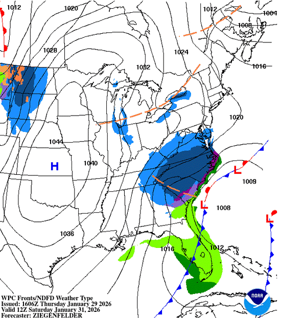
A powerful winter storm, forecast to intensify into a “bomb cyclone,” is expected to create dangerous marine conditions along the US East Coast and Western Atlantic from Saturday through Monday…
Continue reading this post for free in the Substack app
© 2026 Fred Pickhardt
548 Market Street PMB 72296, San Francisco, CA 94104
UnsubscribeBe the first to comment!
New Climate Reports Show ‘Unprecedented Run of Global Heat’ – Inside Climate News (ICN)
Be the first to comment!
Arctic air could hit South Florida for New Year’s Eve, forecasters say – SunSentinel
Be the first to comment!
Antarctic Ice Melt – Fred Pickhardt
Fred Pickhardt’s Substack is free today. But if you enjoyed this post, you can tell Fred Pickhardt’s Substack that their writing is valuable by pledging a future subscription. You won’t be charged unless they enable payments.
Forwarded this email? Subscribe here for moreAntarctica is 98% ice covered and contains 90 percent of Earth’s total ice volume. Melting ice is limited mainly to West Antarctica which is offset by ice mass gains over the remainder of Antarctica.

The mass of the Antarctic ice sheet has changed over the last decades. Research based on observations from the Gravity Recovery and Climate Experiment (GRACE) satellites (2002-2025) and GRACE Follow-On (since 2018) indicates that between 2002 and 2025, Antarctica shed approximately 135 gigatons of ice per year, causing global sea level to rise by 0.4 millimeters per year. Since 2020, however, the Antarctic has seen little or no ice mass loss.

At this rate, an additional 28 mm (1.1 inches) of sea level rise can be anticipated by 2100. If the Antarctic ice melt would triple between now and 2100 we should expect an additional 42 mm (1.7 inches) of sea level rise due to Antarctic melt.
Forensic Marine Weather Expert
You’re currently a free subscriber to Fred Pickhardt’s Substack. For the full experience, upgrade your subscription.
© 2025 Fred Pickhardt
548 Market Street PMB 72296, San Francisco, CA 94104
UnsubscribeBe the first to comment!


Social Media Auto Publish Powered By : XYZScripts.com
Be the first to comment!