Visit Logged
  • Select Region
    • All Regions
    • VA to NC Line
    • North Carolina
    • South Carolina
    • Georgia
    • Eastern Florida
    • Western Florida
    • Florida Keys
    • Okeechobee Waterway
    • Northern Gulf
    • Bahamas
    • New York
    • Ohio
    • Pennsylvania
    • Washington
    • Puerto Rico
    • Minnesota
    • Maryland
    • Tennessee
    Order by:
    • November is Manatee Awareness Month! Slow Down!

      fwc
      October 29, 2015
      Slow down for manatees migrating to warmer waters

      Manatee caution sign

      With winter’s chill approaching, Florida manatees are on the move. Manatees cannot tolerate cold water and may begin to seek warmer water when temperatures start to drop below 68 degrees Fahrenheit. Some travel hundreds of miles to reach a warmer destination. Because of the annual migration, the Florida Fish and Wildlife Conservation Commission (FWC) is reminding boat and personal watercraft operators that it is important to slow down to avoid manatees, particularly in shallow areas.

      Manatees can be difficult to see as they often swim and rest just below the water’s surface. Boaters wearing polarized sunglasses are more likely to spot manatees underwater.

      November is Manatee Awareness Month. There is no better time to plan a visit to observe Florida’s beloved manatees. Find these places by going to MyFWC.com/Manatee and clicking the link under the `Where can I See Manatees?’ box.

      `Watching these large plant-eating mammals swim slowly through Florida waters, often accompanied by their calves, is a special experience for residents and visitors to the state,’ said Carol Knox, the FWC’s Imperiled Species Management section leader. `Boaters following posted speed zones for manatees migrating to warmer waters help conserve this iconic Florida species for future generations.’

      Boaters should be aware that many seasonal manatee protection zones go into effect on Nov. 15 throughout the state. For information about manatee protection zones by county, including the seasonal changes, go to MyFWC.com/Manatee, and click on `Data and Maps.’ At the bottom of that same page, there also is information on FWC Manatee COLD-weather changes to speed zones. FWC law enforcement officers will be on the water enforcing these seasonal rules to protect manatees in busy boating areas.

      People can report sightings of injured, sick or dead manatees to the FWC’s Wildlife Alert Hotline at 888-404-3922, #FWC and *FWC on a cell phone, or with a text to Tip@MyFWC.com.

      The purchase of a Florida manatee license plate at BuyaPlate.com or a manatee decal from tax collectors’ offices in Florida is another way to help manatees. The license plate and decal support the FWC manatee program, including research, rescue, rehabilitation, conservation, management and education efforts.
      fwc6

      Learn more about Florida manatees at MyFWC.com/Manatees. Click on `Manatee Habitat’ to discover what plants they eat when inhabiting Florida’s rivers, bays, canals, estuaries and coastal areas. While on that page, click on `Boat, PWC & Paddle-sport Operators.’ Also check out `A Boater’s guide to living with Florida Manatees’ and `Guidelines for successful manatee watching in Florida.’

      Be the first to comment!

    • Advice for Avoiding the Shoals South of Fernandina Beach, AICW Statute Miles 717 – 720


      Reports of shoaling south of Fernandina Beach have been coming in for several years and prompted a USCG Hazard Warning in May of last year (/?p=140702). Our thanks to cruising writer Robert Sherer, New Intracoastal Waterway Cruising Guide, for sending these charts and waypoints to guide you through the shoals.

      There is a 10 ft MLW path through the shoals south of Fernandina that I took on October 28, 2015.
      Heading south:
      Depart channel 300 ft before R16 aiming for the tongue of deep water shown on chart (Garmin) at a heading of 275M for 17.8 MLW.
      Run along the 12 ft contour line next to shore until the tongue of deep water ends as shown on the chart, then aim for G1 which will be at 245M, pass by 30 ft for 13.4 MLW, higher along the way.
      Important: do not turn immediately around G1 (shoals), continue for 170 ft, then turn due south for 500 ft before turning towards deep water as shown on charts on the green side close to shore. Run just outside the 12 ft contour line down to G3 and G5, 200 ft off. 10.4 MLW entering the 12 ft contour line, deeper after that.
      This passage is difficult because you’re avoiding three shoals:
      – one is in the middle of the marked channel in the bend that’s down to 3 MLW
      – the second one comes out off the eastern shore just south of G1
      – the third one is further south coming off the western shore
      None of these are marked.

      After six years of passing through here, I’ve settled on the above description, it works for no less than 10.4 MLW. The depths were adjusted for not only the tides but also for the higher than normal water levels as reported by the Fernandina weather station. This passage would be easy if buoyed properly, the route has been constant for the pass five years.
      A chart of the route:
      fb1
      fb2
      For those wanting the exact path, here are the waypoints with the usual disclaimers (things can change on the ICW)

      F01
      N 30° 39.804
      W 081° 28.596
      F02
      N 30° 39.805
      W 081° 28.730
      F03
      N 30° 39.853
      W 081° 28.938
      F04
      N 30° 39.803
      W 081° 29.082
      F05
      N 30° 39.713
      W 081° 29.084
      F06
      N 30° 39.613
      W 081° 29.030
      F07
      N 30° 39.409
      W 081° 28.968
      F08
      N 30° 39.254
      W 081° 28.970
      F09
      N 30° 38.824
      W 081° 29.024

      Robert Sherer
      aka Bob423
      Author of “2015 ICW Cruising Guide” available on Amazon.com
      Daily blog at fleetwing.blogspot.com

      Be the first to comment!

    • Tips and Tricks on Marina WiFi Service, Old Port Cove Marina, North Palm Beach, AICW Statute Mile 1014


      Old Port Cove If your marina doesn’t have an onSpot WiFi system, pass this information along. You will be glad you did! Old Port Cove Marina is located on the western shore of the northern Lake Worth channel, near unlighted daybeacon #7. Both Old Port Cove Marina and onSpot WiFi are SALTY SOUTHEAST CRUISERS’ NET SPONSORs!

      Ever pull into a marina desperate to check your messages only to encounter Wifi issues? Don’t blame the marina’s Wifi service! According to Bob Taylor of onSpot Wifi, marinas have a very unique set of circumstances when it comes to providing Wifi service. It might not be the service at all, it just could be your device!
      Read Bob’s very useful TIPS & TRICKS on our blog at www.OPCH.com OLDPORTCOVELD2

      Old Port Cove Holdings is pleased to provide onSpot Wifi service at all three of our marina facilities.
      Thank you boaters for choosing to do business with us!
      Sincerely,
      Sue Morgan, Marketing Director
      www.OPCH.com

      Click Here To View the Eastern Florida Cruisers’ Net Marina Directory Listing For Old Port Cove Marina

      Click Here To Open A Chart View Window, Zoomed To the Location of Old Port Cove Marina

      Be the first to comment!

    • Dredging to Begin in Fort Lauderdale c. AICW Statute Mile 1060


      This dredging is in a relatively short section of the Waterway paralleling Hugh Taylor Birch State Park to the east and north of the Sunrise Blvd Bridge at Mile 1062.5. Unfortunately, this article from Soundings does not give project dates. However, the dredging is in a relatively wide section and should not impact through traffic.

      tradeonlytoday
      Dredging set to start for ICW in South Florida
      Posted on October 26th, 2015
      After several years, permits were issued and a contract awarded for the dredging of the Intracoastal Waterway in South Florida, allowing the vessels that patronize the area’s waterways to have better access to local marinas and boatyards.

      The dredging, which will take place from 17th Street to Sunrise Boulevard to 17 feet deep, will be the largest single public works project for the Florida Inland Navigation District, a special state taxing district tasked with managing and maintaining the Atlantic Intracoastal Waterway, according to the Marine Industries Association of South Florida.

      `The Florida Inland Navigation District’s ICW dredging project will provide an extraordinary benefit to Broward County through the infusion of $20 million by increasing the depth of the ICW from the congressionally authorized depth of 10 feet to a new depth of 17 feet to accommodate the vessels that are seeking to visit, reside and retrofit at our local marinas and boatyards,’ Tyler Chappell, the Broward commissioner for FIND, said in a statement.’

      Be the first to comment!

    • Warning for South Entrance to Jensen Beach Bridge Anchorages, AICW Statute Mile 981


      Our thanks to Skipper Meyer for these words of caution. The twin Jensen Beach Bridge anchorages lie west of the Waterway, north and south of the Jensen Beach bridge, south of unlighted daybeacon #219.

      I entered the south anchorage from the east across the thin strip marked as 6′. It was a bad decision. The depth-finder showed 4’6’³ (my draft) in a couple spots. Managed to hop through but it was nerve-wracking. Will go southeast through the deeper water to exit.
      Chad Meyer

      Click Here To View the Eastern Florida Cruisers’ Net Anchorage Directory Listing For Jensen Beach Bridge Anchorages

      Click Here To Open A Chart View Window, Zoomed To the Location of Jensen Beach Bridge CAnchorages

      Be the first to comment!

    • Cove Plaza Welcomes Marine Industries Association, Old Port Cove Marina, North Palm Beach, AICW Statute Mile 1014


      Old Port CoveA SALTY SOUTHEAST CRUISERS’ NET SPONSOR, Old Port Cove is located on the western shore of the northern Lake Worth channel, near unlighted daybeacon #7.

      Old Port Cove Holdings, Inc. and
      COVE PLAZA
      Are Pleased to Welcome

      unnamed

      TO COVE PLAZA at OLD PORT COVE

      On behalf of our entire staff and management team, I am pleased to announce that the Marine Industries Association of Palm Beach County now hails from Cove Plaza which is located at the entrance to Old Port Cove in North Palm Beach. You will find their new office on the lower level of the 1208 building in Suite B. (That’s the 2nd building after going down the ramp.)

      ABOUT: The Marine Industries Association of Palm Beach County, Inc. (MIAPBC) is a not-for-profit organization created to promote and protect the sound growth of the marine industry in Palm Beach County for the benefit and education of its members, the community, and the environment.

      MIAPBC is also responsible for the Annual Palm Beach Holiday Boat Parade and The U.S. Marine Corps Reserve Toys for Tots toy drive both of which are right around the corner, Saturday, December 5, 2015.

      opcparade

      Please join us in welcoming the MIAPBC to Cove Plaza!

      Questions? Please Contact:
      Alyssa Freeman, Operations Director
      1208 US Highway #1 Suite B
      North Palm Beach, Fl. 33408
      alyssa@marinepbc.org
      Phone: 561-622-1555 (temporarily)
      www.MarinePBC.org
      www.BoatingSouthFlorida.com
      www.PalmBeachBoatParade.org

      Old Port Cove Holdings, Inc.
      Sue Morgan, Marketing & Public Relations Director
      116 Lakeshore Drive
      North Palm Beach, Florida 33408
      561-296-1863
      marinas@opch.com

      Click Here To View the Eastern Florida Cruisers’ Net Marina Directory Listing For Old Port Cove Marina

      Click Here To Open A Chart View Window, Zoomed To the Location of Old Port Cove Marina

      Be the first to comment!

    • Snapshot Report II: Old Port Cove Marina, North Palm Beach, AICW Statute Mile 1014


      Old Port CoveA SALTY SOUTHEAST CRUISERS’ NET SPONSOR, Old Port Cove is located on the western shore of the northern Lake Worth channel, near unlighted daybeacon #7.

      opc3
      opc4opc5opc6
      opc7
      opc8 opc9

      Click Here To View the Eastern Florida Cruisers’ Net Marina Directory Listing For Old Port Cove Marina

      Click Here To Open A Chart View Window, Zoomed To the Location of Old Port Cove Marina

      Be the first to comment!

    • Continued Praise for Huckins Boat Yard, Ortega River, Jacksonville FL


      Huckins Boat Yard is located on the northern shores of the Ortega River off the St. Johns River, just upstream of the Roosevelt Boulevard Bridge with a 45ft vertical clearance. Skipper Alderman joins other skippers in praising Huckins Boat Yard. See /?p=146584 for photos of their work.

      Huckins is the best. We had a fuel tank replaced by them and some more work done to the Leprechaun 440 EB Sea Ray and I can’t say enough about them. They are the top of the line service and very reasonable on their price. Richard and Justin were the best and PJ was on top of everything and Trishia in the office could not have been better. If you need repairs, get it there you will not be sorry.
      Bill Alderman

      Click Here To Open A Chart View Window, Zoomed To the Location of Huckins Boat Yard

      Be the first to comment!

    • Changes at Titusville Municipal Marina, AICW Statute Mile 879


      Located south-southeast of AICW marker #27, Titusville Municipal Marina is one of the best medium-sized, municipal marinas on the Eastern Florida coastline. It is also only a short driving distance from Dixie Cross Roads Seafood Restaurant, one of the best in the south! Our thanks to Captain Seeley for bringing these changes to our attention.

      FYI, Titusville has been turned over to a private management company by the city, as of October 3. The city was dis-allowing live aboards’ over 6 months in a 12 month period. The new management is in the process of changing that. We will see how that develops.
      S and G management out of Milwaukee is the new manager.
      Courtesy van no longer offered, merchants did not support it.
      Captain Douglas Seeley
      dwsco32780@gmail.com
      www.titusvillekeelboatschool.com

      Click Here To View the Eastern Florida Cruisers’ Net Marina Directory Listing For Titusville Municipal Marina

      Click Here To Open A Chart View Window, Zoomed To the Location of Titusville Municipal Marina

      Be the first to comment!

    • Ports to Visit on the Southeast Coast

      Skipper Hoff is responding to a reader’s earlier inquiry about ports to visit on the east coasts of Florida, the Keys and the Bahamas. There are great suggestions here.

      Regarding other locations – we have only stayed at Marathon overnight so can’t really say much about it. We have spent more time at Islamorada, Key Largo and Biscayne Bay, almost always at anchor. We tend to like either remote (Biscayne Bay, Dry Tortugas, etc.) or interesting cities (Key West) – but that is our preference. Biscayne Bay is a place we like to hang out at anchor – swimming, kayaking, walking the beach, etc.

      As you head north we time a stop at West Palm Beach for their Farmers’ Market – one of the best, if not the best, on the east coast and my wife has made me stop at all of them from Maine to Key West. They have a large free day dock we spend all day at then move a couple 100 feet off to anchor for the night – all the benefits of a marina with none of the cost. Let me know if you plan to stop there and I can give you further advice since the peak current can be strong.

      Downtown Ft. Lauderdale (New River) is also an interesting spot – a world away from relaxing in the Keys but interesting to see 100+ foot yachts go by one after another. Good restaurants, interesting people watching, reasonable dockage, etc.. Easy spot to have people arrive and depart from since the airport is very close by.

      If at all possible we try to run outside from Ft. Lauderdale to Lake Worth (just north of West Palm). Otherwise along the ICW there are bridges, bridges and more bridges – plus some crazy boaters. Combine these and it doesn’t make for the most enjoyable travel. However the benefit of inside along the ICW is looking at the huge houses with their 100+ ft yachts docked outside.

      You will probably leave from Lake Worth to cross to the Bahamas. This is where the weather is most important – don’t even consider it with any form for NE wind the day you go or during the previous few days. A few years ago I helped a friend bring a brand new 69 ft Nordhavn back after their maiden voyage crossing in 25 kt NE winds. He said it tossed the 250,000 lb boat around like a cork plus stood it on end a few times – he said they were never sicker in their lives (very experienced boaters having taken a 55 ft Nordhavn all the way to Alaska and back around to New England). His wife wouldn’t do the return crossing so I helped him. Last time I crossed with my Fleming we waited five days for good weather and finally went in what we thought would be ok weather – ended up with 15+ footers out the Gulf Stream – not fun. On the other hand my return crossing on the Nordhavn was ~1 footers – all depends on the day.

      We have only spent time at West End in the northern Bahamas so I can’t say anything about the Abacos. We have spent an entire winter in the southern Bahamas and enjoyed it.

      Hope you find this helpful.

      Regards,
      Curtis

      Be the first to comment!

    • Grounding at AICW/Matanzas Inlet Intersection Problem Stretch, AICW Statute Mile 792.5


      This AICW Problem Stretch has always been one of the shallowest sections of the Waterway in Eastern Florida. Earlier descriptions of the three newest markers, as well as Skipper Justin’s experience, would indicate that shoaling is beginning to reappear. BE SURE to observe any new aids to navigation and, as always on perennial AICW Problem Stretches, be READY for new shoaling and even newer markers as you pass through. Our thanks to Justin for sharing his experience.

      I ran aground hard going north through this passage with current behind me. I kept to the east of the new green buoys because it seemed they were way to close to the western bit of land. I thought they shifted to be a “port” marker (red right returning) because of the meet up with the two channels..My navigation chart was a complete fail to show depth. This place is tricky. I believe I should have kept the green buoys to my starboard, going north. A red marker would’ve helped too.
      Justin

      Click Here To View the Cruisers’ Net’s “AICW Problem Stretches” Listing For the AICW/Matanzas River Intersection

      Click Here To Open A Chart View Window, Zoomed To This AICW Problem Stretch

      Comments from Cruisers (3)

      1. FRank Morris -  October 4, 2015 - 3:16 pm

        I’ve done that section a few times; you almost have to stay close enough to the west bank to touch it with an extended boathook (perhaps not “quite” that closely, but it sure seems like it).
        Frank Morris

        Reply to FRank
      2. Bob McLeran -  October 2, 2015 - 1:54 pm

        This stretch has ALWAYS required proper adherence to the temporary buoys and is not a problem as long as they are honored no matter how close one thinks they’re putting you to the shore.

        Reply to Bob
      3. Dave mcBride -  October 1, 2015 - 7:25 am

        It appears from his statement that skipper Justin went on the wrong side of the greens. Went through here yesterday southbound had no more problems or less depth than ever. Stay in the channel and you’ll stay off the bottom.

        Reply to Dave
    • Praise for Marineland Marina, AICW Statute Mile 796


      The Town of Marineland has opened its ports with a brand new marina facility creating a destination for boaters on the Intracoastal Waterway between Daytona Beach and St. Augustine, FL.

      We continue to hear only good words for SALTY SOUTHEAST CRUISERS’ NET SPONSOR, Marineland Marina which lies south ‘“ southeast of AICW marker #87, along the Waterway’s eastern shore.

      One of the BEST little gems on the ICW! Eric and Chris do their best to help you with any of your needs..very clean’¦the beach right across A1A’¦Plenty of water..definitely would go back! Thank you!
      Payrick n Jae Kellogg

      Click Here To View the Eastern Florida Cruisers’ Net Marina Directory Listing For Marineland Marina

      Click Here To Open A Chart View Window, Zoomed To the Location of Marineland Marina

      Comments from Cruisers (1)

      1. John Pholeric -  September 27, 2015 - 1:28 pm

        I agree this is a wonderful marina. The staff was helpful and friendly. Marineland is definetly worth a visit, and the beach is right across the road. Not much shopping, but can’t have everything. A cab will get you to shopping.

        Reply to John
    • Help Requested to Report Sightings of Diamondback Terrapins

      You can help, especially if you do any anchoring or shore exploring between Canaveral and Miami.

      turtle


      MELBOURNE, Fla. – A zoo in Brevard County needs your help tracking the East Coast Diamondback terrapins, a unique subspecies that lives along Florida’s Atlantic coast.

      The Brevard Zoo wants everyone from the Space Coast to Miami to report sightings to them.

      The terrapins are usually found in brackish coastal waters like the Indian River Lagoon.

      Click here to send sightings along with pictures and GPS coordinates.

      The zoo said the project will help biologists identify critical habitat and road-kill “hot spots”.

      Be the first to comment!

    • Cost of Pumpouts in Florida to be Possibly Paid by Boaters

      As local commissioners struggle to fund the current free pumpout service, it becomes apparent that those costs may soon transfer to boaters, as reported in the article below by Kevin Wadlow in KeysInfoNet.com.

      Boat sewage pumpout costs likely to be assessed on the boaters
      BY KEVIN WADLOW
      A boat-pumpout program launched to protect Florida Keys nearshore waters from sewage discharges stands as a model for the state, but state funding for the program is drying up.

      Money from the state’s Clean Vessel Act “dropped significantly this year,” Monroe County Marine Resources administrator Rich Jones told county commissioners Wednesday at their Key Largo meeting.
      Local contractor Pumpout USA “had a lot of trouble making ends meet this year,” Jones said.
      Monroe County in 2015 will spend about $367,000 on the program, with the state funding around $319,000 toward an estimated 18,000 vessel sewage pumpouts.
      The county’s share works out to $21.10 per pumpout. Overall, average total per-pumpout cost is about $40, down from $55.70 in 2014.
      The state Department of Environmental Protection now seeks “throughout the state to build sustainable pumpout programs, using Monroe County’s pumpout program as a model,” Jones said in a report to commissioners.
      To reduce the number of illegal sewage discharges in Florida Keys National Marine Sanctuary waters, the pumpouts are offered free of charge to boaters. However, commissioners have urged staff to work toward some type of fee system for boaters.
      “I am concerned about the long-term viability of free pumpouts,” Commissioner Heather Carruthers said. “We can’t count on the state for anything.”
      Commissioner Sylvia Murphy said her office receives “a constant supply of comments” from land residents “who pay for sewage” while anchored liveaboard residents “are not paying taxes or rent or anything else, and we’re paying for their sewage.”
      “I like doing something to keep sewage from going in the bay or ocean but sooner or later we’re going to get on the stick and make them pay,” Murphy said.
      Pumpouts are mandatory inside local managed anchoring areas, where Jones said compliance “is close to 100 percent.”
      Commissioners asked about extending the pumpout requirement to all nearshore Keys waters, but questions about jurisdiction and enforcement were cited as potential obstacles. Staff is “looking at any and all alternatives,” Jones said.

      Be the first to comment!

    • Snapshot Report: Old Port Cove Marina, North Palm Beach, AICW Statute Mile 1014


      Old Port CoveOld Port Cove is located on the western shore of the northern Lake Worth channel, near unlighted daybeacon #7.


      Ahoy Boaters!

      September is right around the corner and it will not be long before the search for warmer waters, coconut palms, rum libation, and sea food dining will be the driving forces for the courses we set each day. One of our seasoned sponsors, the Old Port Cove marinas, and yes there are three, North Palm Beach Marina, New Port Cove Marina and Old Port Cove Marina are all ready to add to your full pleasure, comfort and enjoyment. Old Port Cove Marinas are encouraging skippers and or first mates to make advance reservation for slips. After a sell-out season last winter, they don’t want their boating friends to be disappointed!

      Old Port Cove Marina is located off the I.C.W. (Intracoastal Waterway) at Coast Guard Channel Marker #27, four miles north of the Lake Worth (Palm Beach) Inlet. No waiting for bridges and just minutes from the finest cruising grounds in Florida make this location the perfect jumping off spot for the blue waters of the Atlantic Ocean and the Bahamas.
      Marina features include: Proudly 5 Star Boater Rated, State of the Art Floating Docks, Casual Waterfront Restaurant On-Site, Fitness Room, Complimentary Shuttle to Publix and West Marine, BoatUS Member Discount.

      Please make reservations today, we are waiting to welcome you in with a bottle of wine!
      Old Port Cove Marina certainly is an elegant alternative to the hustle and bustle of the marinas to the south. Latitude: 26°49.937’N Longitude: 080°03.248’W
      Call 561-626-1760 or go on line to www.opch.com

      Click Here To View the Eastern Florida Cruisers’ Net Marina Directory Listing For Old Port Cove Marina

      Click Here To Open A Chart View Window, Zoomed To the Location of Old Port Cove Marina

      Be the first to comment!

    • More Good Words for Titusville Municipal Marina, AICW Statute Mile 879


      Located south-southeast of AICW marker #27, Titusville Municipal Marina is one of the best medium-sized, municipal marinas on the Eastern Florida coastline. It is also only a short driving distance from Dixie Cross Roads Seafood Restaurant, one of the best in the south! Our thanks to Skipper Parker for this report.

      Stayed a few enjoyable days at the Titusville Marina. The staff is very courteous and accommodating. The boatside pump out is a plus.
      Susan Parker

      Click Here To View the Eastern Florida Cruisers’ Net Marina Directory Listing For Titusville Municipal Marina

      Click Here To Open A Chart View Window, Zoomed To the Location of Titusville Municipal Marina

      Be the first to comment!

    • Praise for Hawg Wash BBQ in Welaka, FL, St. Johns River


      With a name like “Hawg Wash,” this BBQ has to be good! For a 2013 report on Waleka, FL, see /?p=110746.

      If you visit Welaka make sure you get to Hog Wash for THE Best smoke hog in the STaTe. U will not be disappointed. I promise uuuuuuu
      Pete Baleyko

      Address:413 Elm St, Welaka Fl, 32193. Tel: 386-524-4036. E mail: hawgwashbbqjoint@gmail.com.

      Click Here To Open A Chart View Window, Zoomed To the Location of Welaka, FL

      Be the first to comment!

    • Good Words for Loggerhead Club Marina, Vero Beach, AICW Statute Mile 948.5


      Loggerhead Club Marina lies west and a bit south of the AICW’s marker #122 in Vero Beach, FL. Burkey Marine Group is out of West Palm Beach

      Nice Marina great staff and big help from local marine repair firm Greg Burkey Marine aka bigdieselmarine.com
      Ted Davis

      Click Here To View the Cruisers’ Net’s Eastern Florida Marina Directory Listing For Loggerhead Club Marina-Vero Beach

      Click Here To Open A Chart View Window, Zoomed To the Location of Loggerhead Club Marina-Vero Beach

      Be the first to comment!

    • More Praise for Burkey Marine Group, West Palm Beach

      “No charge” – sweet words to any boater! These guys are building a solid reputation, one boater at a time. Bravo Burkey Marine Group!

      We feel the same way! These big diesel guys helped us over the phone telling us what to look for and once we located the problem they talked us through the repair at no charge. (After hours)
      We are fans!
      Ted Davis

      “Mobile Marine Repair In West Palm Beach Florida”

      Comments from Cruisers (3)

      1. Tim Daily -  November 9, 2015 - 12:50 pm

        Recently used a repair firm to handle an engine shut down situation which was quite scary. The mechanics from bigdieselmarine.com aka Burkey \Marine Group came out right away “as stated several times elsewhere” they handled our big problem easily with minimal cost and lost time! We are passing it on as we should! The number for Big Diesel direct is 772-215-7663
        Tim Daily

        Reply to Tim
      2. bill wilson -  September 14, 2015 - 3:20 pm

        We arrived in Stuart Florida with engine problems at Sailfish Marina and were told to call Greg Burkey Marine group. After contacting Burkey Marine aka Big Diesel Marine we were on our way soon! Happy to pass on the number to our community Burkey Marine group at 772-215-7663 burkeymarinegroup@gmail I feel safe recommending them!

        Reply to bill
      3. Jim Dennison -  August 1, 2015 - 12:02 pm

        We agree we used Burkey Marine Group for the engine service and repair!
        772-215-7663. My wife and I are satisfied.
        Jim Dennison

        Reply to Jim
    • Update: Stolen Yacht Recovered, East Coast of Florida, near Fort Lauderdale

      Our thanks to Mike Ahart, Editor of Waterway Guide for this news:

      Waterway News Updates
      Florida East Coast

      Has anyone seen this stolen yacht?

      Date Reported: Jul 15, 2015
      Reported by: Kevin Crago
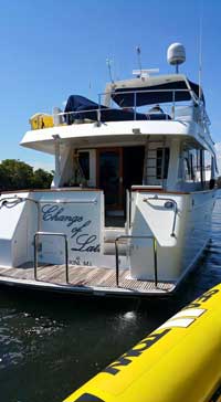
      Changes-Of-Latitude.jpgHas anyone seen me? My name is Change of Latitude. I am a 2002 Ocean Alexander 60′ Pilothouse Motor Yacht. I was stolen Sunday at 1:30AM from Harbour Towne Marina in Dania Beach FL. I am most likely in the Bahamas.

      Please notify Kevin Crago, the Bahamas Defence Force, US Coast Guard, US Customs, US Marshals, or Broward County Sheriff if you see me.

      Ed. note: WG has verified that this yacht has indeed been stolen. Information has been posted elsewhere on the internet suggesting that the boat is missing due to a repossession. The boat had been repossessed a few months ago.

      View location on the Waterway Explorer
      Source: Cruising Boater

      CLICK HERE for the full story from Waterway Guide Latest News

      Comments from Cruisers (1)

      1. Mike Ahart -  July 20, 2015 - 11:10 am

        UPDATE: The yacht has been located, no details are currently available. BOLO (Be On the LookOut) has been canceled.

        Reply to Mike

    Social Media Auto Publish Powered By : XYZScripts.com