The AICW follows the narrow, man-made canal known as Hell Gate between the Vernon and Ogeechee Rivers. These waters have been an AICW Problem Stretch for years. Despite recent reports of shallow water at low tide, this marker by marker, rising tide report from Bob Kovach is good news and good advice for cruisers. SSECN continues to recommend mid to high tide for this passage.
Marine Trader 50 “ALLEZ!” ALL Depths are from the water line. We have a 5 ft Draft High Tide was at 4:11 P.M. Began Transit at 3:32 North Bound at Marker #90 11.3 ft, Marker #89 11.4 Ft Marker #87 10.4 ft Speed 7 MPH, Wind 15-22 MPH Ended Transit 3:39 PM Safe Cruising. Chief Engr Bob, Onboard ALLEZ!
David and Jaculeyn continue sharing the log of Elske via their delightful blog, The Voyage of Elske on America’s Great Loop. A personal note regarding Elske’s title for today’s page, David is a retired Methodist minister. Today’s page recounts their passage through Problem Stretch, Hell Gate, and on to Isle of Hope Marina, A SALTY SOUTHEAST CRUISERS’ NET SPONSOR, which lies along the northwestern shores of the Waterway in the body of a hairpin turn northwest of Waterway marker #46A. Be sure to see FOCUS ON Isle of Hope Marina.
The AICW follows the narrow, man-made canal known as Hell Gate between the Vernon and Ogeechee Rivers. These waters have been an AICW Problem Stretch for years. Looks like the surrounding shallows are once again beginning to creep into the channel. Effective immediately, cautious captains should begin to time their traversal of Hell Gate for mid to high tide. Our thanks to John Wampler for this report.
Passed thru Hell Gate this morning – 3.2 above Vernon View tide datum with 5.3 feet at waterline. John Wampler
Today we celebrate 36 years of protection for Georgia’s special live-bottom habitat that supports wildlife in the Atlantic Ocean and along the southeastern U.S. coast. With your support, Gray’s Reef National Marine Sanctuary will continue to be an area teeming with diversity and an abundance of marine life, supported by healthy habitats in clean ocean waters. CLICK HERE FOR THE FULL ARTICLE
PLEASE NOTE: The purpose of this warning is to remind you to slow down and watch your wake wherever you are, not to assist you in avoiding law enforcement. This specific warning of a speed trap is based on hearsay and it’s the first such we’ve had in a long while. However, a word to the wise calls for carefully watching your speed and wake through this area. If you encounter speed/wake enforcement in Thunderbolt, let us hear from you. Our thanks to Steve and Barb Sipe for this report.
Have heard reports in the past few days of speeding violations being issued on the GA ICW around Thunderbolt, in the area of G33 to G37. Reports indicate LEO’s are stopping vessels for speeding/violation of no wake zones and issuing warnings and in some cases, citations with a fine of $1,000. No specific information as to the enforcement agency conducting the stops, either state or local, not USCG. Might be worth a mention on the site as a problem area. Steve & Barb Sipe Solo 4303 “Maerin”
I am a safe and courteous boater and yes I come from the north, but still south of the Mason/Dixon line. I got stopped just passing Thunderbolt with a sog ( that’s speed over ground for you locals) of 3 kts and a good current against. I was told by GDNR sargent that I had to do idle speed! I asked him what idle speed means and he answered 1000 rpm?? I told him if I did 1000 rpm I would be doing 6 kts. and as others have said no solid object can go through a fluid without making a wave. I got a warning, but the Sabre behind me got $1000…. I must not be looking like the 1%ers!
I try my best to abide by any no-wake or speed regulations but there are two problems: 1) Many, many waterfront homeowners have posted their own “no-wake” signs making it hard to distinguish the real ones from the fake ones. I realize that some homeowners are concerned with excessive wakes, but they have no more right to post these signs than I have to post fake speed limit signs in front of my property. 2) Wakes are subjective, rather than objective. As someone else mentioned, you can’t move a boat through the water at any speed without making some sort of wake. So when does a ripple become a wake? And in whose opinion? How do you defend yourself in court if you get a ticket? We can’t measure a wake height and neither can a LEO.
Someone mentioned boating into a current. If you’re boating into a two knot current, you have to make two knots just to stay in place and four knots to make two knots over ground.
Yes, we should do our best to boat safely and obey boating laws. Sometimes, it’s not as easy as it might seem to people other than boaters.
Rich Tanner S/V Feral Cat- December 3, 2016 - 8:43 am
I agree with Tracy. They are breaking the law, increasing erosion and sometimes creating hazardous wakes. There are reasons for No Wake and speed limits. I absolutely don’t think your publicizing the locations is a good idea.
We call it the Parade. All the boats coming from up north going to Florida. There are a lot of them and it looks like a long parade of boats. We love Yankees the talk fast drive fast have fast women and money. The drive fast thru no-wake-zones and bridges. In Georgia it is against the law to make a wake going under a bridge like the one in Thunderbolt. “No wake Idle speed only” means no bow wake you know the little bitty six inch wake your bow is making; It is a wake. When Yankees slow down from 35 knots to 25 knots that doesn’t count. Thanks for the money. It is only money go as fast as you want. Don’t worry about respecting your fellow boaters tied to the docks in those no- wake-zones
Just conjecture here: went by there in early November and someone chastised me about my wake over the VHF. I have a sail cat and was doing less than 6 kts. My wake was quite minimal. I wonder if soneone’s complaints is causing a crackdown. Let’s keep the wakes down but not get crazy unreasonable.
Because No Wake is ambiguous at best. You cannot move a solid thru a liquid without creating a wake. Add to that a full flood tide on the nose and the Slow Speed – No Wake issue is subjective. That’s how I talked my way out of a citation near Vernon View.
Causton Bridge had been closed to navigation for repairs over this past weekend, but has now been partially repaired allowing traffic through a single span. With a closed vertical clearance of 21 feet, the Causton Bluff – Sam Varnedoe Bridge crosses the Waterway at Statute Mile 580.
Longtime cruiser and SSECN Contributing Editor, Captain Jim Healy, shares his knowledge and experience in these observations on this portion of the Atlantic Intracoastal Waterway. Thank you Jim!
The entire region from Charleston to St. Augustine has high tidal ranges, ranging from 5′ at St. Augustine to as much as 9′ in Savannah/Beaufort/Charleston. Those high tidal ranges create swift tidal currents, and especially for first-times, docking is easiest in the 1/2 hour before and after slack.
There are many areas of shallow water in the region. The very best resource for current data on low water and caution areas is available via www.activecaptain.com. Two other websites that all ICW travelers should know about are www.waterwayguide.com and www.cruisersnet.net. I’m sure you are familiar with the Waterway Guide book series. The “Salty Southeast Cruiser’s Net” (SSECN) is really a boating group. It was founded by Claiborne Young. After Claiborne’s untimely loss, the group continued in operation. The Cruiser’s Net website specializes on the US Southeast. There is some duplication of material between the WWG site and the SSECN site, but there is unique value to both. Both are excellent resources for fuel prices, marinas and anchorages. These websites would make a good sidebar for any ICW article. Two of these websites require registration – SSECN does not – and all three are free, and all are very useful to ICW boaters. Both WWG and SSECN also have smart phone apps that duplicate and augment website information and are very useful on small-format devices.
There are some generalizations that apply to the region, including the stretch from Georgetown, SC all the way south to below Fernandina Beach. In some of those areas, boats drawing more than 4′ will want to consider not traveling at low tide; especially celestial low tides. The Army Corp of Engineers (USACE) is responsible for dredging the ICW. USACE is funded by state congressional delegations. In recent years, the money congress allocates to dredging has been diverted to “more pressing needs,” and so many areas of the ICW are shoaling, and in fact, the ICW resource is slowly being lost; well, allowed to die, really, by congress. There is a not-for-profit called the Atlantic Intracoastal Waterway Association. The Executive Director is Brad Pickel; bpickel@seahavenconsulting.com. That would make another sidebar for any article on the ICW. There are some local knowledge bypasses around some shoal areas. All of the cruising sites above can provide additional detail.
Renting a car in any of these venues greatly expands what a boating visitor can see and do. Some, but not all, marinas have courtesy cars. Generally they can’t be used for long periods, but they are useful for re-provisioning when needed.
Hope this helps.
Jim
Peg and Jim Healy aboard Sanctuary, currently at Ft. Myers, FL
The Ridleys continue their log with a report on Isle of Hope Marina, A SALTY SOUTHEAST CRUISERS’ NET SPONSOR! which lies along the northwestern shores of the Waterway in the body of a hairpin turn northwest of Waterway marker #46A. And in case you missed their FOCUS ON, see /150925.
5-3-16 Now at Isle of Hope Marina at MM590. Went to fuel dock first– $2.09/gal. Dock (34′) and 30 amp for $75.00. great place to walk around old homes, etc. cable not work but pulled several channels off antennae. Put us on very northern end and very weak wifi. OK for email but not much else. Loaner car and bicycles available and a reasonable ships store. Strong Verizon. Really a great place to stop. Jackie and Charlie on Traveler.
Isle of Hope Marina – A SALTY SOUTHEAST CRUISERS’ NET SPONSOR! – lies along the northwestern shores of the Waterway in the body of a hairpin turn northwest of Waterway marker #46A. And in case you missed their FOCUS ON, see /150925.
Have been at ISLE of hope now for about 2 1/2 years the staff is and has been great. The showers are always kept clean (you can always come in behind some one who leaves it messed up but the staff jump on it and make sure it’s cleaned. Restraints are close and downtown is full of things to do. Thanks and will probably keep coming back as we start our island hopping. Nick on the Cavalier
Praise from Still Clueless parallels the many positive comments by other cruisers, as well as my personal experience there. Thunderbolt Marine flanks the Waterway’s southwestern shores just northwest of the small, charted square cove, south of AICW marker #35.
We cannot say enough about this marina! Easy in, easy out. FREE laundry! Awesome restaurant (Tuby’s) is just a short walk away. Immaculate shower/bathrooms. A true bargain! Will be back next summer, and every fall here out! Still Clueless
According to a spokesperson at the marina, the MLW in the entrance to Delegal Creek is 3 ft with a tidal range of 8-9 ft and, as Cap’n Parky confirms, mid to high tide would be the best time to enter Delegal Creek. Once in the creek, there is plenty of depth, however the entrance channel is an issue if you draw more than 3 ft. The entrance channel begins northeast of waterway flashing daybeacon #86. just north of Hell Gate.
Recently had the opportunity to visit Delegal Creek Marina at Mile Marker 601 a few miles south of Isla of Hope. This is the best and friendliest marina I have stayed at for a while. Certainly it’s probably a good idea to enter the creek a couple of hours before or after low tide – which gives you an easy channel around 8ft or more. The marina offers a lower transient rate than average while at the same time giving first class facilities well sheltered from inclement weather. Super clean restrooms and showers, laundry, floating slips, clubhouse, and above all a courtesy golf cart giving you a delightful run through the woods of Skidaway Island to the Publix grocery store, Bar & Grill restaurant and other stores at the Village. If you have a motorised dinghy – great fun also visiting nearby tropical island beaches. I give it a Five Star rating. Call Dockmaster Billy in advance for a reservation at (912) 224 3885. Cap’n Parky
This is an oasis, hidden from almost any perspective. Once you slip in it’s a place you want to stay. Mike was the Dock master and he greeted me with open arms and they are the nicest people you will ever meet. I docked talked to Mike a second and grabbed the golf cart and went to the Village to eat. No fuss no worries just enjoy the many vistas that are around every corner. The facilities are excellently maintained and the dock is clean and free of “things”. No live a boards makes a difference to the transients that frequent here. I am on my way to Houston TX and will be comparing all to follow to this Village. And for the faint at heart they will drive out, drag you off a spoil area, and when you get in treat you like a Captain. Don’t ask how I know. Michael Dindore
Isle of Hope Marina – A SALTY SOUTHEAST CRUISERS’ NET SPONSOR! – lies along the northwestern shores of the Waterway in the body of a hairpin turn northwest of Waterway marker #46A.
Follow the gentle curves of the Intracoastal Waterway to the Isle of Hope Marina, nestled in the middle of the scenic historic neighborhood of Isle of Hope and located just minutes away from Downtown Savannah, Ga. Founded in 1926, the marina is ideally positioned for relaxation and Southern hospitality.
Watch the sunrise from your boat or enjoy it while strolling along beautiful Bluff Drive, taking in the eclectic mansions and picturesque Spanish moss. And no trip to Isle of Hope Marina would be complete without walking, driving, or biking down the majestic oak-lined avenue of the Wormsloe Plantation, fantastically located less than a mile from the marina.
The Isle of Hope Marina can be found west of Marker 46A at ICW Mile 590. Enjoy your stay on 4,000 feet of concrete floating docks, including 600 feet of deep-water face docks capable of accommodating mega-yachts (up to 220 ft.). Our dockage amenities include a fuel dock with gasoline and diesel (volume discounts), metered electric (30, 50, & 100 amp; single phase), an electronic security system, pump-out, and complimentary digital TV and Wi-Fi. The bathrooms, showers, and coin operated laundry room are clean and secured after hours by key card access. Please note that the Isle of Hope Marina is the last southbound fuel stop on the ICW for 90 miles.
Take advantage of complimentary morning coffee and the Wall Street Journal, and be sure to browse the Ship Store for afternoon ice cream treats and other fun goodies. Hop in one of our two complimentary loaner cars for provisioning, shopping, and eating just a mile and a half down the road in Historic Sandfly. If you prefer more physical activity, pedal away on a complimentary bicycle or swim some laps at the community pool between Memorial and Labor Day. There’s no shortage of friendly people, pets, and scenic views on this beautiful island and our overwater pavilion is a great spot for a picnic lunch or a place to sit and get some fresh air.
Isle of Hope Marina 50 Bluff Drive Savannah, Ga 31406 912-354-8187 www.iohmarina.com ICW Skidaway River Mile 590, Marker 46A
A SALTY SOUTHEAST CRUISERS’ NET SPONSOR!, Isle of Hope Marina lies along the northwestern shores of the Waterway in the body of a hairpin turn northwest of AICW marker #46A.
Isle of Hope Marina, Savannah, Georgia Isle of Hope is a great place to stop. It’s not real close to Savannah but they do offer loaner cars. The cars are loaned out for 2 hours, if more time is needed you can call the Marina and if no one is looking to borrow the car they will let you have it longer. Since we wanted to go to Tybee Island and do so some shopping, taking more than just 2 hour, we called Enterprise rent a car, this was a Saturday morning, They said they would be there by noon. We were stood up. Tried to call them back after waiting for an hour but they close at noon on Saturday. The Tybee Island trip was shot. Monday we called Enterprise rent a car, spoke to a manager, they apologized and set up another delivery. Again we cooled our heels for 45min. The gal in the marina told us to take one of the cars and not to worry about the time. Saved our day, we got to see Savannah, do the carriage rides and all. That evening upon our return we talked to the marina and they confirmed that again Enterprise was a no show. I will no longer trust Enterprise to pick you up. Close to Isle of Hope is the Wormsloe plantation. A good relaxing, walking, sightseeing, history and nature sight. We loved it. We also enjoyed the restaurants in the area. All in all we did enjoy our stay, the crew at Isle of Hope are great, helpful in every way. Phil and Sandy Herl
A SALTY SOUTHEAST CRUISERS’ NET SPONSOR!, Isle of Hope Marina lies along the northwestern shores of the Waterway in the body of a hairpin turn northwest of AICW marker #46A.
Loved this marina! Our first visit here, but will not be our last. Very friendly and helpful ‘“ loved the little town and Driftaway Cafe. Be careful to check operating hours, however. They were closed upon our arrival ‘“ we had made reservations on line and I had my home phone on contact so they were not able to let me know. Only tiny thing to say could use improvement is washer/dryer needs updating and the free roaming of a dog (boxer) who belongs to a marina resident. Ann Bearden
Most of our postings dealing with Savannah speak of cruising west from the Waterway, up the Savannah to downtown Savannah, certainly a delightful sidetrip. SSECN Contributing Editor, Captain Jim Healy, gives an account of the areas around the Savannah River/ICW junction, including Thunderbolt and Tybee Island. Thank you Jim – definitely a good read!
Enjoyed reading this post by Capt. Jim. We always enjoy visiting Savannah by boat. Bought our last boat @ Sail Harbor and had the yard haul and do some work after the survey. The bottom Job is still good now nearly 3 years later. Exceptional service and came in under estimate which is always good. Highly recommend their staff for repairs and service. Sonny
Skipper Johnson’s remarks parallel positive comments by other cruisers, as well as my personal experience there. Thunderbolt Marine flanks the Waterway’s southwestern shores just northwest of the small, charted square cove, south of AICW marker #35.
Had a stuffing box failure on the way north from Florida and was lucky enough to make it to Thunderbolt. Their yard treated me as if I was I was their only customer. Stayed at the marina after repairs were done and more than enjoyed the free donuts in the morning. Highly recommended. Wayne Johnson svPaws
Here are good words for Thunderbolt Marine as originally posted on Trawler Forum, http://www.trawlerforum.com/. Thunderbolt Marine flanks the Waterway’s southwestern shores just northwest of the small, charted square cove, south of AICW marker #35.
Thunderbolt Marina is only in walking distance to Tubby’s Tank House. However, they may still have donuts in the morning for transients. Out at Thunderbolt cabs would be my preference to get into town. They may have city bus service out there. I don’t know that they have a courtesy car. Don on “Monstruck”
Here are good words for Isle of Hope Marina as originally posted on Trawler Forum, http://www.trawlerforum.com/. A SALTY SOUTHEAST CRUISERS’ NET SPONSOR!, Isle of Hope Marina lies along the northwestern shores of the Waterway in the body of a hairpin turn northwest of AICW marker #46A.
Isle of Hope is a good marina, and sometimes has a loaner car, but walking distance to nowhere. Don on “Moonstruck”
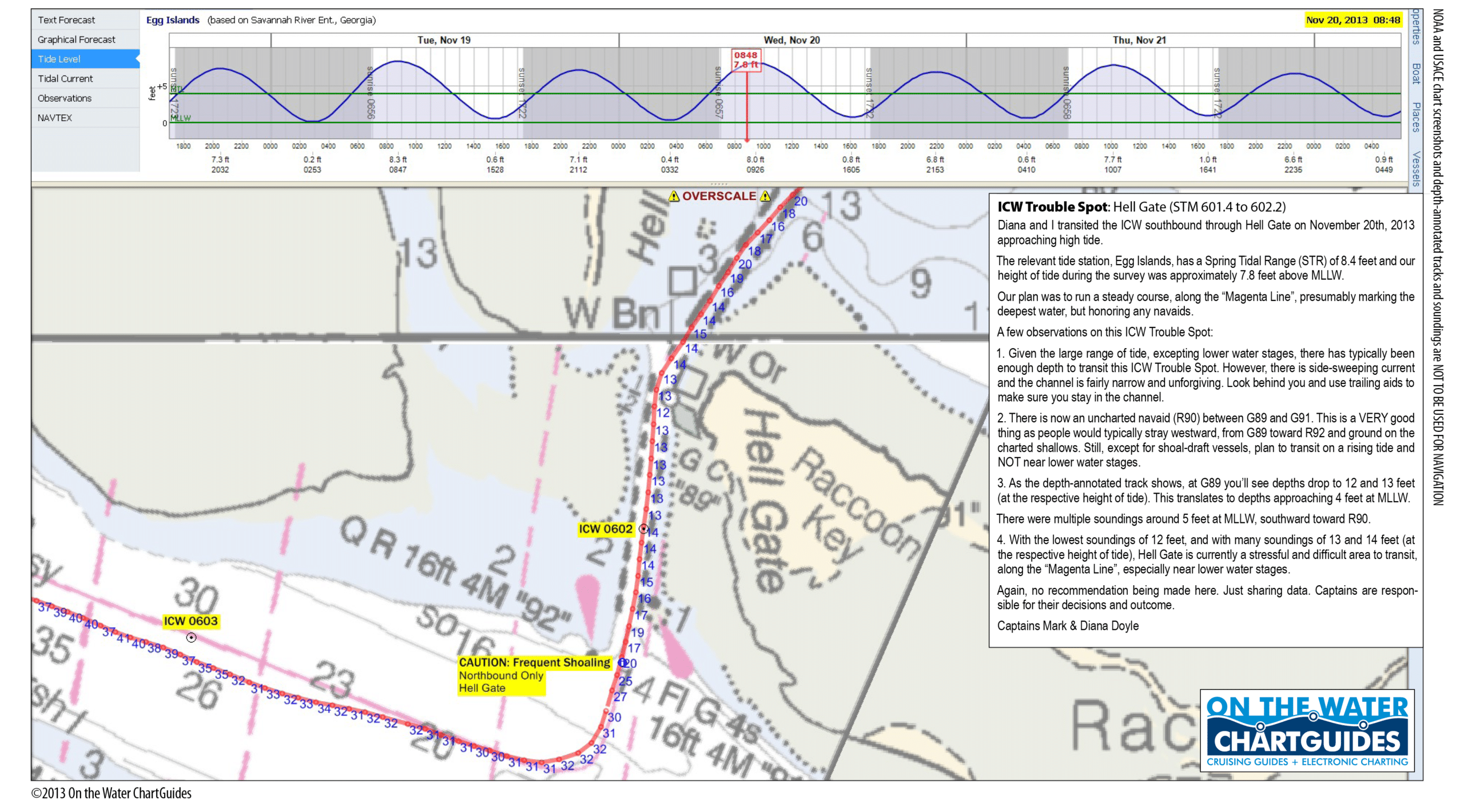
Our good friends, and SSECN strategic partners, Captains Mark and Diana Doyle, founders and owners of “On The Water ChartGuides” (http://www.onthewaterchartguides.com/), give us an updated, graphic report below, relaying what they discovered as they navigated through the AICW Hell Gate Problem Stretch on 11/20/13! Note that the Doyle’s soundings were taken near high tide, so to calculate MLW depths, you must subtract 7.8 feet from their figures. Applying this correction, Diana and Mark noted “multiple soundings around 5 feet at MLLW, southward toward R90.” PERHAPS THE MOST USEFUL PART OF THE DOYLE’S REPORT, IS THEIR DISCOVERY OF A NEW, UNCHARTED MARKER, #90, LOCATED BETWEEN CHARTED MARKERS #89 AND #91! Be sure to observe the new #90 marker as you cruise through! Incidentally, Diana and Mark have recently published a new edition of their immensely popular “ICW CruiseGuide.” Click on the book graphic to the above left for more details, and to place an order!
Hi Claiborne, For those transiting Georgia, Hell Gate has a new, uncharted navaid that should help passage through the shallower sections of this perennial ICW Trouble Spot. I’ve attached a printable high-resolution file of our November 20th survey report and depth-annotated track. Hopefully, SSECN readers cruising this area will find the report useful. Best and hope to see some of the Cruisers’ Net gang at this year’s St. Marys Cruisers Thanksgiving! Captains Mark & Diana Doyle m/v Semi-Local http://www.OnTheWaterChartGuides.com
Just transited Hell’s Gate on 11DEC2013. Delivery of 58′ power vessel with 5’4’³ draft. Passed through at 0620, with tide at approx +2.2. Minimum depth noted was approx. 2.5′ under under running gear. Captain Rob Welling
According to a spokesperson at the Delegal Creek Marina, their entrance channel MLW depths are 3 ft, with a tidal range of 8-9 ft, so mid to high tide would be the best time to enter Delegal Creek. Once in the creek, soundings improve, but clearly this marina’s entrance depths are an issue if your vessel draws more than 3 ft. Delegal Creek Marina’s entrance passage lies northeast of AICW marker #86. just north of Hell Gate.
Sanctuary and crew spent a couple of days at Delegal Creek Marina from 11/6 – 11/9/2013. The entrance to Delegal Creek from the Vernon River/Ossabaw Sound IS NOT correctly drawn on the chart (US5GA24M) of the area; the land features have changed since the chart was produced. Cruisers can download a “local knowledge” satellite view chart from the marina website, or contact Billy, the dockmaster at Delegal Marina, for local knowledge. The region has a 6′ – 7′ tidal range, larger during celestial periods. Sanctuary and crew entered Delegal Creek about 1 hr after celestial low tide (16h00, 11/6/2013), which wound up being equivalent to MLLW on our tide almanac. There is only one short stretch of shallow water on the entire route from the Vernon River to the marina. For about 20 – 30 yds immediately upstream of G’3′ and R’4′, we saw as little as 4.9 ft. at MLLW. Except for that stretch, water depths in Delegal Creek are not a concern. Minimum depths in marina slips are 6′ all the way against the inner wall. Depths at the fuel dock and face docks exceed 20 ft. The facility is very well protected, has floating docks, wi-fi, restrooms, showers and laundry. Broadband WLAN coverage is 4 bars and fast. Facilities are “newish,” well maintained and clean. Marina guests can get a “pass” from the dockmaster that allows access to all of the member-only clubs, including the several golf courses, in the Landings community. There is a small commercial center that has banks, ATMs, a food market, shoppes and restaurants. Golf carts are available for touring the Landings communities and Skidaway Island. Billy makes every effort to help visitors. This is an excellent stop. Peg and Jim Healy aboard Sanctuary, Monk 36
When we were there July 1, I created a JPG graphic to show the route in. I sent it to the dockmaster so they could us it on their web site to help boaters feel more comfortable about the entrance. Well since reading your post, I looked on their web site and now they have a fancy graphic of GOOGLE MAPS view showing the approach. It’s a PDF file that can be seen if you click on either of the following hyperlinks: Delegal Creek Approach Chart
We also found this marina to be very CUSTOMER SERVICE focused. We arrived just minutes before a major thunderstorm. Needed to get milk and bread but didn’t want to take the golf cart into town because of the imminent storm. The girl working the dock actually knocked on our boat and offered to go to the store for us ! We were so grateful ! Ralph Yost


Be the first to comment!