Good news for Sarasota boaters! Big Sarasota Pass which, with its frequent channel shifts and shoals, connects the Gulf with the Gulf Waterway and the southern tip of Sarasota Bay. No time line is given for the dredging project.
The Florida Department of Environmental Protection has granted a permit to dredge Big Pass as part of a Lido Key shoreline re-nourishment project. State grants permit for proposed Big Pass dredge from YourObserver.com
Captain A.J. Hammer has given Cruisers’ Net permission to share excerpts from his blog, Adventures of OLOH. In these logs you will find beautiful photographs of and comments on the sights and scenes along the waters plied by the M/Y OLOH.
FROM: The Captain – Conditions_ Sun and clouds. Winds from the southeast 10-15 mph. Seas 2-3 feet. Distance traveled_ 56 nautical miles Time underway_ 7 hours 33 minutes
Last dredged in 2017, Carolina Beach Inlet is noted for shoaling and a shifting channel. The approximate location of uncharted buoy 4, re-positioned in May, is marked with a pin on our Chartview. Local knowledge is strongly recommended for navigating this inlet.
1.MARINERS ARE ADVISED THAT SHOALING HAS BEEN REPORTED BETWEEN CAROLINA BEACH INLET BUOYS 4 AND 5 ACROSS ENTIRE CHANNEL TO A DEPTH OF 2 FEET MLW. MARINERS ARE ADVISED TO USE EXTREME CAUTION WHILE NAVIGATING THIS AREA.
Our thanks to Bill Parlatore for permitting Cruisers’ Net to post his article on an issue that has been noted earlier, see Vessel Documentation Renewal, and serves as a good reminder to us all.
Beware of official-looking documents designed to take your money. When it comes to renewing your vessel documentation, don’t fall for this type of scam.
Our sincerest thanks to Greg and Barbara Allard for sharing their thoughts and beautiful photography from their Bahamas cruises. These photos and descriptions will have you aching to follow in the Allard’s wake! Enjoy this last of 2018 Letters from the Bahamas!
Hello everyone –
Well, tropical storm Alberto turned to the west, and in the Bahamas we were fortunately left with some rains and wind. The weather in the Bahamas this season was challenging at best. We had a terrific time, but there were long periods (sometimes a couple of weeks) where we had to hunker-down in a safe anchorage or marina to escape some tough conditions.
That is all part of cruising – being prepared to be in remote places, and equipped to understand the weather and your options.
This will be our last Letter from the Bahamas for this season. We have already crossed the Gulf Stream, are back into the U.S., and are down in the Florida Keys. We have to return to the west coast of Florida by going through the Keys because the Okeechobee Waterway, which we normally take across the state, is closed due to a repair on a lock.
A ship in port is safe, but that’s not what ships are built for.
—Grace Murray Hopper
At Allen’s Cay, near Highbourne in the Exumas. This is an old, wooden Chesapeake Bay Buy-Boat, which has been converted to use as a live aboard in the Bahamas. Years ago, in the Chesapeake, it was the boat to which all the smaller fishing boats sold their catches. The larger boat would then take the catches (most often fish and blue claw crabs) to the processing plant ashore, allowing the smaller boats to keep fishing.
Barbara holds a live Queen Conch with beautiful markings, and a small piece of brain coral found on the beach.
The Bahamian stromatolites are living examples of Earth’s earliest reefs. The only open marine environment where modern stromatolites are known to prosper is the Exuma Cays in the Bahamas. These are on the east coast of Highbourne Cay. The little rods sticking up from the formation are markers put there by geologists to monitor their size and location.
Here’s more information than you probably wanted to know: “Stromatolites are rare in today’s ocean but living stromatolites have been found along the margins of the Exuma Sound, including Lee Stocking Island, Stocking Island, Highbourne Cay, Little Darby Island, and in the Exuma Cays Land and Sea Park. Stromatolites are the oldest known macro-fossils, dating back over three billion years. They form an unusual and special type of reef structure in shallow water. Unlike most present-day reefs, which are composed of coral, stromatolites are formed by microorganisms. Scientists believe that the photosynthetic activity of cyanobacteria are the most important group of stromatolite-forming micro-organisms generating oxygen in our atmosphere.” (From Bahamas.com website)
A beautifully marked Bluehead, a member of the wrasse family.
From the sublime to…..Miami. We left the Bahamas five days ago, and crossed from Bimini to Key Biscayne, just south of Miami. When we were about ten miles out from Miami, this was our view. What a contrast – going from the laid-back life in the Bahamas to the largest city in Florida.
Key Biscayne is an island just south of Miami, and in the bay are the famous stilt houses. The area is called Stiltsville, and the houses were constructed many years ago. Hurricanes have eliminated all but seven of them. After a prolonged legal battle, the National Park Service which had control of the area has permitted their continued use. The final seven stilt houses have all been grandfathered; no more can be built, and if they are destroyed, they cannot be rebuilt. There are no year-round residents; they are used as recreational cottages.
On the west shore of Key Biscayne is this curious concrete structure, approximately 200’ x 100’. Richard Nixon’s summer White House was located approximately where the two new homes are, in the rear of the picture. His was a one story, unpretentious ranch style house, long ago torn down to allow for the construction of these modern Miami style things. The massive piece of concrete was his helicopter landing pad, constructed at the request of the Secret Service. The current owner has faced it with wood and pilings, to allow for the docking of boats, and to take the edge off its monolithic appearance.
Our son Chris joined us on his boat, Pendana, which he was bringing north from Key West; here Pendana is anchored off Key Biscayne with Miami in the background.
If Miami is one thing, it is constant bedlam. (For an excellent novel about Miami and its diverse population, read Tom Wolfe’s superb book “Back to Blood.”)
There is a huge shallow sandbar, located just off Nixon’s helipad, and the area has come to be known as Nixon’s beach. This was a beautiful hot Saturday, and literally hundreds of boats showed up, and either anchored within a few yards of each other in the shallow water, or rafted up to other boats. The music from each and every boat was deafening and conflicting, the dancing intriguing, and many boats were overloaded. Yes, there was some drinking and other stuff going on too…..
Another view of Nixon’s beach. We are not quite sure how any boat could “Resume Normal Safe Operation” here.
Several of you have asked if we saw any damage from the most recent hurricane Irma. It was everywhere, and the Keys are still recovering. This sailboat is hard aground on a large shoal.
At the rear of the photo is the famous Seven Mile Railway Bridge which is at Marathon in the Keys. In the early years of the 1900’s, when Henry Flagler built the railroad to link Key West with the mainland of Florida, this railway bridge was considered the Eighth Wonder of the World. Many parts of the railway were destroyed in a hurricane in 1935, rendering the entire line unusable. On the other side of this defunct railway you can see the supports of the newer roadway.
Pigeon Cay is a small island about halfway along the seven miles of water spanned by the bridge. It was used as a work camp while the railway was being built, and up to 400 workers lived there. This part of the remaining unused railway bridge is over 100 years old, and for its age looks in decent condition, perhaps even better than many bridges still in use in the U.S. Plans are to reopen it, in a couple of years, to pedestrian traffic from nearby Marathon. To the right of the house in the distance is the roadway to Key West. The island is now an historic site.
This historic building was the commissary, dating from approximately 1912. Hurricane Irma blew it off its foundation, and the only thing which stopped the building from being swept off the island was the gumbo-limbo tree along the left side of the house. At the height of the hurricane, the entire island of Pigeon Cay was covered with five feet of water.
The lighthouse at Alligator Key. The dozens of boats surround it because it is a fine fishing and diving site.
Two final pictures: this beautiful print of a plush garden scene captures the grace of the Bahamian people.
And lastly…a fine ocean view from Stella Maris, on the east coast of Long Island in the Bahamas.
In these Letters, we have tried to capture the beauty of The Bahamas – not just the physical beauty of its palm tree studded islands, spectacular beaches and gin-clear water, but more importantly the wonderful nature of the Bahamian people: kind hearted, ever-helpful, with an unfailing sense of humor and a pace of life which is, quite simply, civilized.
We sincerely hope you have enjoyed these Letters. Warmest regards to you all.
Our thanks to Bev Burger for confirming (sadly!) that Topsail Island Bridge is not at the old charted 65ft, but 64ft as noted in a NCDOT notice in 2012: https://cruisersnet.net/3862. Why the clearance gauge board was incorrect is unknown. See https://cruisersnet.net/45168.
Topsail Island Bridge (at milemarker 252.5) is shown as a 64’ fixed bridge. Upon approach (with a very clear 65’ +) we hit the bridge with our anchor light. (We need 64.5’ clearance and did not have any issues with other bridges marked 65’.) We estimate the bridge is off the markets by 1/2 – 1’. Please proceed with caution.
And we know the bridge is listed at 64’ in the guide, but the markings on the bridge showed a clear and visible 65’ which is why we proceeded. So not only is the bridge a lower bridge, but the markings from the water line are what are not correct.
Our sincerest thanks to Greg and Barbara Allard for sharing their thoughts and beautiful photography from their Bahamas cruises. These photos and descriptions will have you aching to follow in the Allard’s wake! Hopefully there will be more letters in the weeks ahead.
Letter # 6
Hello Everyone – This season the weather in the Bahamas has been challenging. For the last month we’ve had continuous high winds, repeated thunderstorms, heavy rain, and some nasty lightening; all of these are conditions which make it difficult to find shelter, or to move from one place to another.
We finally were able to find a “weather window” to leave Stella Maris marina on Long Island. Because of the water depth, we had to depart at full high tide, which was at 6:00 AM. That gave us only about a foot and a half under the keel, but enough to keep us from going aground.
(For the cruisers who read this letter, the Stella Maris marina is an excellent place to stop. While the marina is small and has been neglected, it’s part of the larger Stella Maris resort on the eastern side of Long Island, and visiting mariners have full access to all of the facilities. It also allows you to visit Long Island without making the trek down the east side to Clarence Town, which is open to the prevailing winds from the east. Just plan to enter and leave at high tide, which we observed to be about an hour and half after the Nassau projections. Tides are affected by the winds and phases of the moon, so take those into account.)
The winds were somewhat moderate the day we left Stella Maris, so we by-passed George Town and started up the Exuma chain to Cave Cay. We spent several days at Cave, and since we were now on the Exuma banks side (the western side of the Exuma cays), we were somewhat sheltered from the strong ESE winds. After exploring the area near Cave, we moved up to one of our favorite anchorages in the Staniel Cay area – Big Majors spot, which offers excellent protection from ESE winds. From there we went to Warderick Wells, one of the most beautiful places in the Bahamas.
This Letter covers our time at Cave, Staniel, Warderick, and our current location, Highbourne. Since some of those places have access to good coral reefs for diving, we’ll spend some time looking at their superb underwater sights.
Dinghy expeditions – one of our favorite pastimes. Our dinghy is our car. It takes us places we can’t go with the bigger boats. There are literally hundreds – if not thousands – of secluded beaches just like this one. We often take the dinghy ten or twenty miles from where we have left our larger boat. We look for islands and cays to explore, beaches to comb and coral reefs to dive on.
The beach combing is superb. Here are some colorful shells for the collection.
While walking the beaches, we found some beautiful pieces of black coral. We do not take live coral from the reef; we only take what nature has discarded. These pieces were likely torn from the reef in a storm, and washed up on the beach where we found them. When this coral is growing on the reef, it looks very different – the branches are covered with different colors of outer coral. This black coral is actually the skeleton. It is often used for making jewelry. A yellow fan coral, also found washed up on the beach. Both the black coral (above) and this fan coral were found on the beach at Highbourne,
It’s important to remember that within the boundaries of the Exuma Land and Sea Park (south of Highbourne), you are not permitted to fish, capture lobster, or even take any shells or coral (dead or alive) from anywhere in the park.
Running in the dinghy between Musha Cay and Rudder Cut Cay. The dark water is about 15-20’ deep. The lighter blue is 5-10’ and the very light colored water to the left is about 2’.
There are a number of sunken planes in the Bahamas. Some are from failed drug runs, years ago, and others are planes that just didn’t make it. The runways on the smaller out-islands are simple: mostly crushed coral, and not all that long. This plane is located just off Little Lansing Cay. One of the blades of the propellor is sticking up at the front of the plane.
The sea is quick to take over any foreign objects thrown its way. In this photo of the plane’s wing, several different corals have already taken root.
The Bahamas are not volcanic; all of the islands and cays are composed of limestone, which has tendency to be worn away and create blue holes, land caves, or sea caves. This one, at water level, was deep enough to drive the dingy inside.
A large Southern Sting Ray, skimming across the bottom. His barb sticks up about halfway down the tail. They only use the barb defensively and will not affirmatively attack you. The only risk is stepping on one who is sleeping in the sandy bottom which may cause the ray to whip you with his tail and barb; the injury is painful. For this reason, we use the “sting ray shuffle” when walking in shallow water: instead of stepping, we shuffle our feet across the bottom, which will move the ray along, rather than cause him to react badly. This ray was about 3’ across – small compared to the Spotted Eagle Rays which we will show you later.
On the west side of the Exuma chain (the banks) there are huge areas of shallow sandy water which cover and uncover with the tides. After I took this picture, two juvenile Black Tip Sharks (2’ and 3’ long) circled around me about 25’ away, in two feet of water. When I moved towards them with the camera, they scooted away. This shallow area is between two cays, which are owned by a celebrity….
The illusionist David Copperfield owns several cays in the area: the two main ones are Musha Cay, where he has a large home, and the adjacent Rudder Cut Cay, with his private airstrip.
We are always searching the charts for areas of coral, which make good diving spots. This small “patch reef”, in the cove just east of Musha (near to the small inlet) has some nice specimens of Elkhorn coral. The silvery area at the top of the photo is the underside of the surface of the water.
There is also a larger reef, with very good diving and more Elkhorn, just off the east-facing beach below the Copperfield house.
This school of Palometa, almost translucent, swam by near one of the Copperfield reefs. They are members of the Jacks family, and also known as Longfin Pompano.
Not something you see everyday – an underwater sculpture of a Steinway grand piano, with a mermaid leaning against the bench. It is in 15’ of water off the southwest end of Rudder Cut Cay. It was placed there by David Copperfield.
Thunderball Cave is located near Staniel Cay, where the James Bond movie of that name was partially (about 20 seconds worth…) filmed. It is a great snorkeling spot, with a big cave which is easy to swim into at low tide, but the real beauty is in the coral formations which surround the little cay. This Purple Fan Coral is superb. In the right foreground is a light colored Symmetrical Brain Coral, and if our identification is correct, at the upper right are some Porous Sea Rods, olive green in color. Sometimes it is difficult to accurately identify the hundreds of types of coral, and while we have excellent guides with color photos, we are still learning.
A gap in the reef, showing the path to deeper water.
A Green Sea Turtle casually swam underneath me. Their name does not come from the color of their shell (which is brown), but from the green color of their fatty tissue. They are remarkably fast. This is a younger turtle; fully grown they are are 4’ long and weigh between 250 and 450 pounds. They are endangered.
In the middle of all the natural beauty, there is always something unusual or even strange, mostly man-generated.. On occasion in the U.S. smaller boats will sometimes raft together – that is, tie up to each other while anchored. In Big Majors Spot we came upon this raft-up: three large boats all tied together, sitting on one anchor; they stayed that way for several days and nights, during unsettled weather with periods of strong winds. We estimated the largest mega-yacht to be about 170’ long, the middle one about 100’, and the smaller sportfish boat at 70’. If the single anchor on the largest boat were to drag, the result could turn bad very quickly. Boats are note like cars, where you start it and go. There are preparations to be made before getting underway, the engines on all of the boats would have to be started and all of the lines connecting the boats untied before the raft-up can be split apart. Also notice that at the stern of the sport fish there was yet a fourth boat (a center console), rafted across the stern.
What was most surprising was that the small sailing catamaran, directly behind these three hulks, seemed happy to be anchored there for several days, breathing in the 24 hour-a-day fumes of at least three large generators, and taking the risk that they would not drag down on him in the middle of the night. During one of the season’s endless rainstorms, this little frog fellow appeared on our windshield. We had seen him elsewhere around the boat, and figured that he had become a stow-away on Long Island, about ten days before.
While diving at the “Coral Garden” at Warderick Wells in the Exuma Land and Sea Park, we spotted these two massive Spotted Eagle Rays in the distance. Their wingspan looked to be eight feet across, and their overall length with the tail was about 20’. There was no way we could keep up with them while swimming, but we anticipated that they would swim around the rock formation on the right and circle back towards us.
The winds were rather high this day, and the resulting waves stirred things up, making the water clarity less than normal.
Circle back they did. The water here was approximately 25’ deep, so this photo does not convey how huge these animals are. While no real threat to us, swimming near a living creature so impressively large grants you a humble sense of perspective.
One of them swam right under our friend Jim Pope, who was close enough to take this beautiful photo showing the Spotted Eagle Ray’s distinctive markings.
Our next stop was Highbourne Cay. When you venture off the regular paths, you always discover something new – this man tends a growing herd of goats, and maintains a beautiful herb garden, helping the cay to be more self sufficient. Walton Stephenson While walking on one of the ocean-facing beaches on Highbourne, we came upon this Piping Plover nest. The nest had been built between the arms of a large branch of black coral, which drew our attention to it, and fortunately prevented us from stepping on it. The owners of the nest, the male and female piping plovers, immediately took action. They both ran away from the nest on the beach in different directions, feigning that they had broken wings, by dragging their wings in the sand as if they were injured – all in an attempt to make predators (us) think that they were easy pickings, and to draw us away from the nest and eggs.
A magnificent Queen Triggerfish, one of the most beautiful and distinctive fish on the reef.
Right now we are in the northern Exumas, dealing with a tropical weather system which has been developing in the Gulf of Mexico. Strong winds are forecast for the coming week, so we are monitoring that system closely.
Several years ago we included the following quote from Mark Twain. Many of you have seen it before; it has become common because it says it the best. Of course it does not just apply to being on a boat. “Twenty years from now you will be more disappointed by the things that you didn’t do than by the ones you did do. So throw off the bowlines. Sail away from the safe harbor. Catch the trade winds in your sails. Explore. Dream. Discover.” Mark Twain, 1835 – 1910
Warmest regards to you all.
Greg and Barbara
Share:
Comments from Cruisers (1)
Laurie- June 17, 2018 - 4:32 pm
Thanks for all the letters….we find it fantastic to follow along with you Laurie
Tangier Island is a very special place, definitely one of those never-to-be-forgotten spots in the Chesapeake. If you have not visited this step back in time, do it now before it’s gone.
A combination of storm-driven erosion and sea-level rise, which are both increasing as climate change advances, may soon swallow the island entirely.
Explorer Chartbooks, A CRUISERS’ NET PARTNER, has long been the standard navigational supplement for enjoyable, informative, and safe cruising through the beautiful Bahamian waters and island visits.
Hi All, We will be cruising the lower Exumas and SE Bahamas in June. Can anyone direct me to a resource for SSB frequencies and schedules for weather broadcasts. Thank You!
Gray’s Reef National Marine Sanctuary protects Georgia’s special live-bottom wildlife habitat in the Atlantic Ocean and along the southeastern U.S. coast, an area teeming with diversity and an abundance of marine life.
The Gray’s Reef Sanctuary Advisory Council provides the Office of National Marine Sanctuaries with advice and recommendations on the management of Gray’s Reef National Marine Sanctuary. The council members include community stakeholders from fishing, diving, conservation, science, education, citizens-at-large, state agencies, and federal agencies.
We are currently accepting applications for the following council seats:
Gray’s Reef National Marine Sanctuary is celebrating World Ocean Day at the University of Georgia Marine Education Center and Aquarium on Friday, June 8 (10:00 a.m. to 3 p.m.).
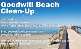
On Saturday, June 9, help the Gray’s Reef NMS Foundation and friends with a beach cleanup on Tybee Island. Meet the Tybee Clean Beach Volunteers at the Pier and Pavilion at 9:00 a.m. For a parking pass and volunteer t-shirt, be sure to register here.
We wrap up June with Georgia Department of Natural ResourcesBeach Week events on Tybee and St. Simons Islands, June 28 & 29. Learn all about Georgia’a wild Atlantic coast and underwater treasures during World Ocean Month!
Old Port Cove Marina, A CRUISERS’ NET SPONSOR, is located on the western shore of the northern Lake Worth channel, near unlighted daybeacon #7. North Palm Beach Marina is found on the southwestern banks of the Waterway south of the North Palm Beach/Parker Bridge.
Our thanks to Greg Allard for this onsite report and photos from Bimini.
Bimini Entrance Buoy Update – as of May 31/June 1, 2018 from Greg Allard
1) When approaching Bimini, at the harbor entrance, there are three buoys, two red and one green.
2) The red buoy, furthest to the north, is off-station, and it sits on a sandbar. Ignore it.
3) The other two buoys, one green and one red, are used to enter the harbor.
4) As you approach, look for the narrow rock lined entrance into Bimini Sands Marina on South Bimini. You will see the other two entrance buoys, generally lined up with the entrance to Bimini Sands. These are the two buoys you will use.
5) Navigating eastward, the first buoy (red) is the western most buoy of the two; the second buoy is further east, and is green, and it appears very near to the shore in front of Bimini Sands.
6) As to the first red buoy, to us it appeared that there was deeper water to the right of it (as we entered.) That is, the water appeared deeper on the south side of that red buoy. That is the path we took, and there was 12’ plus depth. Many local boats (or non local boats following everyone else) passed the red one on the “correct” side, that is, they left the red to their starboard. The water there looked “OK”, but not as deep as the water on the south side of the red.
7) After passing the red, then head for the green buoy. There appears to be a sandbar that has crept south slightly into the channel before the green buoy, so you should swing slightly to the south to clear it. If you are going to North Bimini, pass the green buoy as you would normally (to port), and then make an approximate 90 degree turn to port (north) which will take you into the well marked channel towards North Bimini. (If you are going into Bimini Sands, put the green to your port and go straight in to the entry channel which according to the dockmaster, has 6’ at low tide; I believe he is correct from what we saw.)
We did not go into N. Bimini, but at almost low tide, in the outer entry channel near the red and green buoys, we consistently had 10”+ of water depth. That of course is based on the exact route we took. As they say: your depth may vary. See the important note below.
Here are some photos, which will help illustrate the route.
View looking EAST. Bimini Sands marina is in the background. The red buoy you will use to enter is in the left foreground. We are passing on the “wrong” side, since the water appeared deeper to us there.
The buoy further away is the green, which as you enter you should leave to port, and then turn north (to port) about 90 degrees to pick up the clearly marked channel into N. Bimini.
This is the view of the same two “good” buoys, looking WEST, coming out of Bimini Sands.
The view looking NORTH from the “good” red buoy. In the far left distance, is the off-station red buoy which you don’t want to use for anything, since it is on a sandbar.
NOTE: We watched many small boats pass the red on the “correct” side, but then we observed a steel freighter about 150’ long coming south out of N. Bimini.
she turned west at the green near shore, and then she passed the RED on her starboard side – that is what would normally be the “wrong” side.
In other words, that boat confirmed for us that the deeper water is on the south side of the red buoy.
Explorer Chartbooks, A CRUISERS’ NET PARTNER, has long been the standard navigational supplement for enjoyable, informative, and safe cruising through the beautiful Bahamian waters and island visits.
New Information from the Chub Cay Resort regarding the Berry Islands Club:
The Berry Island Club has been closed from the summer 2016. They sustained major damage during hurricane Matthew of that year.
The owner of Chub Cay Resort purchased it earlier this year and hopes to have it open for November- December of 2018 as a Bonefish Lodge. It will be another getaway for guests staying at the Chub Cay Resort.
Explorer Chartbooks, A CRUISERS’ NET PARTNER, has long been the standard navigational supplement for enjoyable, informative, and safe cruising through the beautiful Bahamian waters and island visits.
Effective July 1, 2018, the Bahamas VAT will increase to 12%. This increase will be devastating! If you search on-line, you can read much more about the controversy. The only concession they’ve made for the residents is that some “breadbasket” food items will be VAT free, but the list is VERY specific & VERY short. This will hurt businesses too, especially restaurants – this new VAT along with a 18% gratuity will result in 30% onto a restaurant bill – Yikes!
We cruisers aren’t going to like this either. Also announced were a slew of various other increases including immigration fees – unknown yet if that will include Cruusing Permit fees…
Our sincerest thanks to Greg and Barbara Allard for sharing their thoughts and beautiful photography from their Bahamas cruises. These photos and descriptions will have you aching to follow in the Allard’s wake! Hopefully there will be more letters in the weeks ahead.
Letter # 5
Hello everyone: Once again we’ve had to send two Letters in close succession, to take advantage of the good internet connection at this marina. This is likely to be the last Letter for a couple of weeks.
Our report from Long Island continues.
Barbara and I both grew up on Long Island, the one in New York, which is 120 miles long and has a current population of 7.8 million.
The other Long Island, the one where we are at the moment, is in the Bahamas. It is 80 miles long, has a population of 3,500 people and there is not one traffic light on the entire island.
Once we entered the waters towards the southern end of Long Island, we had a small milestone event: we crossed the Tropic of Cancer. This sign on Long Island shows the location of the line, and once south of it, we were officially in tropical waters. Jerome Hawes was born in 1876, and studied for five years at the Royal Institute of British Architecture. He then undertook studies at the Lincoln Theological College, became Father Jerome, an Anglican priest, and in 1910 designed this church on a hill above Clarence Town on Long Island. He later went to Rome, studied for three more years to become a Catholic priest, and then in 1939 designed the Catholic church on the far hill, to the right rear of the photo. Local sources say that the Catholic church was not completed until 1946. Both churches were strongly built to survive the frequent hurricanes; they still stand proudly over the town.
Father Jerome’s Catholic church. While we were looking at the Anglican church, the woman on the left came up to me and allowed us to go inside. She is a member of the congregation. She was also excited to show us her new home, and gave us directions to get there. Her name is Sandra Dean, and her husband is Jeremiah. This is their new home, which sits on a beautiful hill overlooking the harbor and the ocean. They gave us a tour and we found it to be simply furnished and filled with beautiful breezes from the sea. This house was built to replace their prior one which was destroyed in a hurricane. We stopped at the Glinton School in the northern part of Long Island, to drop off some school supplies. We met the principal, Ruth Smith, on the left, and her assistant Claudette Adderley. They gave us the warmest welcome. No visit to a school is complete without some pictures of the children. The Bahamian educational system is excellent, the children are well disciplined, and many go on to higher education. There are 34 students enrolled at this school, and some of them are shown here and below. One of the teachers, Tangela Bain. We met Stanley Pinder, a farmer on Long Island. He gave us some of his beautiful just-picked peppers. He’s over 80 years of age, and has lived on the island his entire life, save for a few years in the U.S. as a farm worker. Long Island is one of the few Bahamian islands which has a flourishing agricultural industry. In fact, they grow enough produce to export it to other Bahamian islands. A Bahamian “fast food” restaurant. Regular menu items would be chicken or ribs, mac and cheese, beans and rice, all served in a square styrofoam lidded box. These places do a good lunch business. Alfred, who with his wife operates this small bake shop. We bought loaves of white bread, some cinnamon buns and a delicious piece of lemon cake. It’s likely that a combination of old age and a hurricane or two destroyed this church. The Bahamians are a religious people – even the smallest of towns have at least one or two churches. At the French restaurant, Chez Pierre. A fine lunch, good wine and a great companion. St. Mary the Virgin Anglican Church, now in ruins, reported to have been built by the Spanish in the late 17th century. Hopefully, it will someday be restored. We collect Bahamian baskets, first of all because we like them, but more importantly because the Bahamians who make them are skilled artisans who carry on a trade which may not last forever. Over the years we have visited Ena Majors’ shop in Clarence Town, where she showcases high quality baskets made by local people. Our friends and us bought the ones on the counter. Ena Majors. She is 82 years of age. Long Island is the home of Dean’s Blue Hole, a spectacular 660’ deep hole, reputed to be the deepest in the world. It is supposedly connected to the ocean at its bottom. This is the site of yearly competitions with participants from all over the world, to see who can set a record by going down the deepest while holding their breath, without SCUBA, or any other devices. Some of the contestants reach 250+ feet. The white raft in the middle has a line which the divers use to guide them. It is an extremely dangerous sport. On the rock to the left of the picture, surrounded by three cherubs, is a plaque listing the people who have died while diving here. The cause their deaths, simply stated, is blacking out from lack of oxygen. My task is to send Letters, not to make judgments. We went looking for the delicious pineapples which are grown on Long Island, but it was a bit early in the season. In Turnbull, we met Leroy Gibson while he was walking along a road, and the conversation turned from pineapples to other subjects. He liked to verbally joust, and when I eventually asked to take his picture, he said: “I never want my picture taken, but you can take it.” This is the result.
DCIM100GOPROGOPR1279.
Life can be difficult in the Bahamas. Fishing is one of the main ways to earn a living. This fisherman’s boat, Lady Max, dragged her anchor, and came to rest in shallow water. It will be difficult to salvage the boat, and his livelihood. There was one day where the sun poked out for a couple of hours, and we were rewarded with this view. Look carefully at the name of the boat.
Hopefully this rainbow is a sign that better weather is on the way. When that happens, we can head north again, back through the Exumas.
Warm regards- Greg and Barbara Copyright, Greg Allard
Explorer Chartbooks, A CRUISERS’ NET PARTNER, has long been the standard navigational supplement for enjoyable, informative, and safe cruising through the beautiful Bahamian waters and island visits.
INTRODUCING A NEW OPTION FOR REPORTING YOUR PLEASURE BOAT ARRIVAL TO CBP
Hello SVRS member,
It is our pleasure to announce that U.S. Customs and Border Protection (CBP) is launching the CBP Reporting Offsite Arrival – Mobile (ROAM) app, a new way for pleasure boaters to report their U.S. entry in select locations nationwide! This app provides pleasure boaters with a convenient and efficient way to report their U.S. entry from a personal device, as opposed to calling their local CBP number. Please note: Float plans are no longer required, and the Small Vessel Reporting System (SVRS) is being discontinued in the coming months. A notice will be posted to the SVRS website with a specific date and thereafter all travelers will be directed to utilize the CBP ROAM app. Your SVRS, Local Boater, or Registered Traveler numbers will remain in effect and can be utilized and saved within the app to expedite reporting.
What is the CBP ROAM app?
The CBP ROAM app is a free mobile application that provides a new and faster option for pleasure boaters to report their U.S. entry to CBP. Travelers can use their personal smart device (or a tablet located at partner businesses) to satisfy reporting requirements in select areas. All travelers, regardless of nationality or citizenship, are eligible to use the CBP ROAM app.
Where can the CBP ROAM app be used?
Currently, the CBP ROAM app can be used to report U.S. entry by pleasure boat in Florida, select locations in Minnesota, and in the Great Lakes and Saint Lawrence River area between Buffalo and Ogdensburg, NY. Additional locations are being added, and travelers should contact their local port of entry to confirm whether arrival submissions via the CBP ROAM app are accepted.
Download CBP ROAM on your Android or Apple device! Detailed instructions on how to install and use the app on a personal device are attached for your reference. Click Here to download CBP ROAM App Instructions.pdf
For more information on the CBP ROAM app, visit the CBP ROAM page on CBP’s website. For CBP ROAM questions or comments, please reach out to cbproam@cbp.dhs.gov.
This program is a pilot and is still under development; please report any difficulties or comments to this email box and we will respond as quickly as possible.
Happy boating and stay safe!
U.S. Customs and Border Protection
Click Here to download CBP ROAM App Instructions.pdf


Be the first to comment!