NOAA: Ocean Today Video – Save Sharks
Sharks aren’t the man-eaters portrayed in the media. Learn how shark encounters stack up to other dangers like vending machines!

Sharks aren’t the man-eaters portrayed in the media. Learn how shark encounters stack up to other dangers like vending machines!
A great article by Jackie Au of the Dockwa Team for folks thinking of casting off from land holdings.
Liveaboards: 15 Things to Consider!
By Jackie Au, 3/18/22 8:30 AM
This new law went into effect March 14 and establishes increased boat-to-dock limits on most of South Carolina’s major reservoirs. The law does not apply to the Intracoastal Waterway.
|
Charleston County Parks, A CRUISERS NET SPONSOR, announces the return of three Yappy Hours at James Island County Park. Pooches and owners are invited for an evening of live music, drinks and off-leash fun. First Yappy Hour is April 21st.
Click link for Yappy Hour: A Party in the Dog Park this Spring!


Gulfport Municipal Marina, A CRUISERS NET SPONSOR, and the City of Gulfport always have a full calendar of events for all ages. Located in the heart of downtown, the marina and harbor, found on the northern shores of Boca Ciega Bay, are easily accessible from the Western Florida ICW, just north of Tampa Bay.

Homeless Program, Madeira Pioneers, and Coconut Charlie’s
Copyright © 2022 Thursday Morning Media – The Gabber Newspaper – The Beach Barnacle, All rights reserved.
Our mailing address is:
Thursday Morning Media – The Gabber Newspaper – The Beach Barnacle
Gulfport, Fl 33707
Click Here To Open A Chart View Window, Zoomed To the Location of Gulfport Municipal Marina
Click Here To Open A Chart View Window, Zoomed To the Location of Gulfport Anchorage/Mooring Field
Last week was National Invasive Species Awareness Week, and the red lionfish has gained increasing attention since the nonnative predator first began to appear in waters off the NC coast about 20 years ago.
Lionfish an example of needed invasive species awareness
CoastalReview.org

A longtime CRUISERS NET SPONSOR, historic Edenton always has an exciting calendar of events! Edenton is at the mouth of the Chowan River on the northwest shore of Albemarle Sound.
| ||||||||||||||||||||||||||||||||||||||||||||||||
|
Click Here To Open A Chart View Window Zoomed To the Location of Edenton Harbor City Docks
Coastal Carolinians are very aware of the dangers of “pluff mud” that is exposed with the tidal extremes. The small coastal creeks and waterways are so inviting to small craft explorers and while the pluff mud may look firm, but it is dangerous for humans and pets. Recently a St. Bernard fell off a pier at low tide and was saved only by giving the dog a large flat cushion to climb upon. The experience left the frightened dog exhausted.
Kayakers trapped for hours in chest-deep mud as tide rose around them, NC rescuers say – The State
The State
Cruisers Net is proud to be a member of the Atlantic Intracoastal Waterway Association whose lobbying work is crucial to keeping the Waterway navigable and safe. Your membership dollars directly support their vital work. Please join and encourage your boating neighbors to do likewise, regardless of their homeport.

Click here for FOCUS ON Atlantic Intracoastal Waterway Association
|
IPCC is the United Nations body that looks at climate change science.
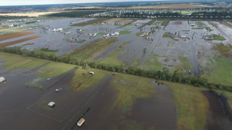
Aerial view of the flooding in Moyock during Hurricane Matthew. Photo: Currituck County
World must act now to slow global warming: report
CoastalReview.org
Have you ever scoured the beach hunting for that perfect sand dollar to take home as a souvenir? Or perhaps plucked one of them out of the water? It could’ve been alive.

Dead or alive? 3 ways to spot the difference between a live sand dollar and souvenir
The News and Observer – Ashley Jean Reese
Shackleford Banks is a barrier island running roughly east/west between Cape Lookout and Beaufort Inlet.
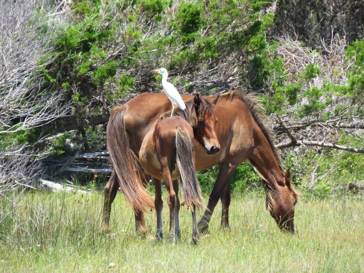
121 horses on Shackleford Banks at end of 2021: report
CoastalReview.org
Being self-sufficient at sea takes preparation
Passagemaker, Chris Caswell, 2/2/2022
Charleston County Parks, A CRUISERS NET SPONSOR, is proud to announce a new yoga program beginning in April.

New Sunrise Yoga program coming to Charleston County Parks in April
Click Here To View the South Carolina Cruisers Net Marina Directory Listing For Cooper River Marina
Click Here To Open A Chart View Window, Zoomed To the Location of Cooper River Marina

Pamlico River enters the northwest shore of Pamlico Sound and is home to Washington City Docks, A CRUISERS NET SPONSOR.
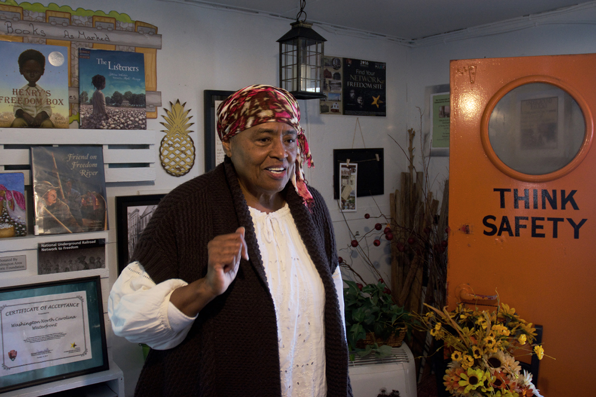
Leesa Jones is dressed as an enslaved person of the 19th century as she tells the story of the Underground Railroad and Washington at the museum where she is executive director. Photo: Kip Tabb
Click here for For some, Pamlico River was part of underground railroad by Kip Tabb
CoastalReview.org
Click Here To Open A Chart View Window, Zoomed To the Location of the Washington City Docks

A different perspective of the ICW by friends from across the pond, this report covers the ICW from Albemarle Sound to Virginia, including the Dismal Swamp Canal where the Welcome Center, A CRUISERS NET SPONSOR, keeps watch over cruisers.

Exploring the Atlantic Intracoastal Waterway
Yachting Monthly, Katy Stickland
When fog sets in, these 11 tips can help you at the helm.
Click here for Adventures in Fog Navigation by Douglas M. Wartelle
PassageMaker.com


 ️
️ 


Be the first to comment!