Keys History by Brad Bertelli
When East Florida and West Florida were still Spanish territories, they were wild, sparsely-populated frontiers.

KEYS HISTORY: LIEUTENANT DECLARES U.S. POSSESSION OF KEY WEST SOME 200 YEARS AGO
Keys Weekly
When East Florida and West Florida were still Spanish territories, they were wild, sparsely-populated frontiers.

KEYS HISTORY: LIEUTENANT DECLARES U.S. POSSESSION OF KEY WEST SOME 200 YEARS AGO
Keys Weekly
TopSide Marinas is a family owned marina company that is looking to buy and operate marinas – they are not a broker – and they would love to meet marina owners who are ready to sell. TopSide Marinas is A CRUISERS NET SPONSOR!

Video Introducing TopSide Marinas
Remember when you used to pull into a marina and the person helping you dock was probably the owner. Marinas operated by families with family values, family hospitality and friendliness became “old friends” and we looked forward to seeing these friends again with each cruise. It was as if we were living the lyrics from the theme song for the TV program, “Cheers” … remember ?… “Making your way in the world today takes everything you’ve got, taking a break from all your worries sure would help a lot. Wouldn’t you like to get away? Sometimes you want to go where everybody knows your name and they’re always glad you came….”
The environment in which marinas operate today is rapidly becoming more complex. There are an increasing number of regulations that must be followed to keep our waters clean and our stays safer. Providing potable water, electrical power, fuel, Wi-Fi, safe docks, carts, and professional staff to assist, while earning enough money to continually invest in the infrastructure and operations is and has been essential to a marina’s survival.
To say life was simpler in the past is an understatement. The marina where we keep our is our on-the-water neighborhood, and we don’t want that comfortable, friendly, and enjoyable ambiance to disappear. Keeping that warm hospitality and “Cheers ambiance” around our homeport marina is becoming a challenge.
Meeting that challenge is the passion of Stephen Lehn and Jacob Boan, co-founders of TopSide Marinas. Ever heard the expression, “mid-western values”, used to describe someone’s solid work ethic and high standards? Well, that describes Stephen and Jacob. They also grew up in families that loved family time on the water! This team knows the value of having safe, enjoyable and fun times on the water. Doesn’t matter if it is located on the coast, near coastal, on rivers, bays or lakes, the common denominator is precious water! Marinas often become the second or even primary homes for many boaters.

TopSide Marinas was formed just last year, 2020. Their mission is simple: To foster a high-quality environment where our customers can create lifelong memories, relax, enjoy life and be healthy. Their research has shown that time spent in and around oceans, rivers and lakes promotes health and wellness. Time on the water can be very good for us.
With a strong family orientation, the team at TopSide Marinas is looking to work with marinas who are now ready to move on to something else, but don’t want their marinas and longtime customers to lose the specialness that has taken years to development. As owners/sellers they want the new owner to be ready to invest in the enterprise to bring it up to date, improve the quality of service, enhance their customers’ quality time at the marina, making it a second home. These are the core values of TopSide Marinas. Both Stephen and Jacob have worked in executive capacities with a large corporate owner of marinas and their operational business experiences, educations, personal family boating experiences, are guiding them in their devotion to their customers’ marina and boating enjoyment.
Stephen and Jacob are always on the lookout to bring high quality marinas into the family. In their own words,
We understand that for many marina owners, selling their marina is much more than a transaction, it is like selling your longtime family home, where your children were raised and years of memories have occurred. Yes, as current owners, you want a fair price and may want to sell to someone with similar values. TopSide can offer both. We are family owned and we consider our marina customers to be part of our family. So if you own a marina, then we would love to initiate a conversation with you. Whether you are curious about the value of your marina, thinking about transitioning ownership, looking for strategic partners or any other reason, please click here to provide us with your preferred contact information. We are looking forward to talking with you.
TopSide Marinas’ most recent acquisition: Beaver Bend Marina
Cape Fear River sunset, from Fort Fisher State Park

Winston: Beautiful photo – with perfect composition. Nicely done.
As the new year begins and with a look toward improving our service, Cruisers Net would really like to get some feedback from you our readers. Rather than a formal survey, we ask that you send us comments on the main items on our website, weekly newsletter and mobile app:
Homepage daily postings
Homepage sidebar information
Local Notices to Mariners
Current Fuel Prices
Weekly Newsletter
Environmental postings
Political postings
Education/ Entertainment Calendars
Sponsor Articles and Promotions
Simply reply to this posting, saying as much or as little as you like, even as simple as “I use…” or “I do not use…”
Your Cruisers Net Team truly appreciates your patronage and looks forward to hearing from you!
Many Thanks!
Your email address will not be published. Required fields are marked (required). All "Comments/Reviews" submitted to the Cruisers' Net are reviewed by our editorial staff before being published.
|

The Bahamas has suspended the mandatory RT-PCR testing requirement for vaccinated travelers, which was expected to take effect on 7 January 2022. Vaccinated persons, as well as all children ages 2-11, may continue to present either a negative Rapid Antigen Test or negative RT-PCR Test.
In addition, effective 4 January 2022, all persons remaining in The Bahamas for longer than 48 hours will be required to undergo a Rapid Antigen Test, regardless of vaccination status.
To see more details of these protocol changes, please click the ‘Learn More’ button below.
A humorous look at mal de mer. Our thanks to Winston Fowler for sharing this link.
The Grant Game by Chris Caswell
PassageMaker
The Charleston District of the U.S. Army Corps of Engineers is responsible for 15 navigation projects along the South Carolina coast, stretching from Little River Inlet near the North Carolina border to Port Royal Harbor on South Carolina’s southern coast.

USACE Charleston District survey team helps maintain South Carolina waterways – Army.mil
Army.mil
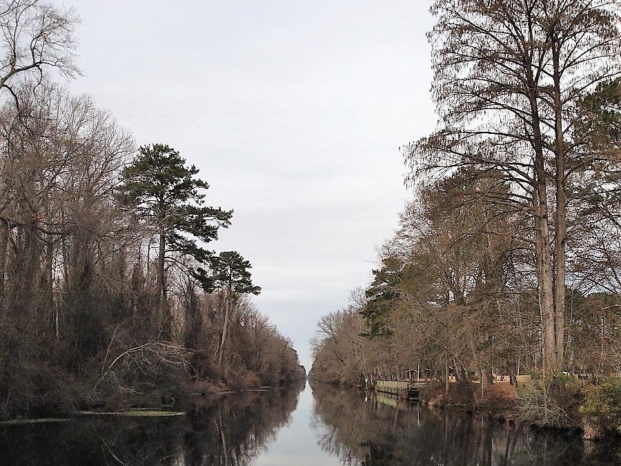
The Dismal Swamp Canal Welcome Center is located adjacent to the Dismal Swamp State Park, offering trails, exhibits and ongoing programs in Camden County, NC. Docks are provided by the Dismal Swamp Canal Welcome Center, A CRUISERS NET SPONSOR and a NC DOT Rest Area facility.

The Great Dismal Swamp Canal, which was opened in 1805 and widened in 1829 with the use of slave labor, passes through Camden County. Photo: Eric Medlin
Camden’s history, economy rooted in Great Dismal Swamp
CoastalReview.org
Key Lime Sailing Club, A CRUISERS NET SPONSOR, always has very special offers for their visitors! Key Lime Sailing Club is a unique slice of KEYS ENJOYMENT…give it a try and let us hear about your experience.
|
|
|
|
|
|
|
|
|
|
|
|
|
| ||||||||||||||
| Copyright © 2021 The Islands Of The Bahamas 1200 South Pine Island Rd., Suite 450, Plantation, FL. 33324 | ||||||||||||||
What are the requirements if arriving by boat. Consider the fact that it could take 4-5 days Jacksonville, FL to the Bahamas on the ocean or you could blow a 3 day test waiting for an appropriate weather window to leave FTL or , WPB or MIA and cross to the West End or Bimini.
Walburg Creek Anchorage is off the AICW and accessed from MM 619 or 623.5. Our thanks to Ted Arrisaka for sharing this photo. This editor and crew have spent many a night here.

Click Here To Open A Chart View Window, Zoomed To the Location of the Walburg Creek Anchorage
One of Georgia's gems! Sandy beach by the north entrance at low tide. Beautiful sunset over the marsh to the west. Good protection. From the wind E thru SSE. Good holding, ground tackle comes up clean.
The Florida Fish and Wildlife Conservation Commission and the U.S. Fish and Wildlife Service have announced a “supplemental feeding” plan to save malnourished manatees on the Atlantic coast.
Supplemental feeding for the malnourished manatees | Science & Technology | crimson.fit.edu
The Florida Tech Crimson
In tandem with pollution, jet skis are wreaking havoc. These can easily go over 50 mph. Neither manatees, human swimmers, nor birds have a chance against them. Jet skis are highly unsafe, noisy, pollute, and, for all the above, need to be illegal on public waterways.
This situation occurred several years ago when the Save the Manatee Club made its big push. The ideal is super, but the reality is not. Yes, they are large docile creatures that have a place in Florida. However, when steps are taken to increase their numbers above and beyond what the natural food supply will support, the situation that we have now takes place. Mess with Mother Nature, and you create a second problem. I guess it is a steep learning curve.
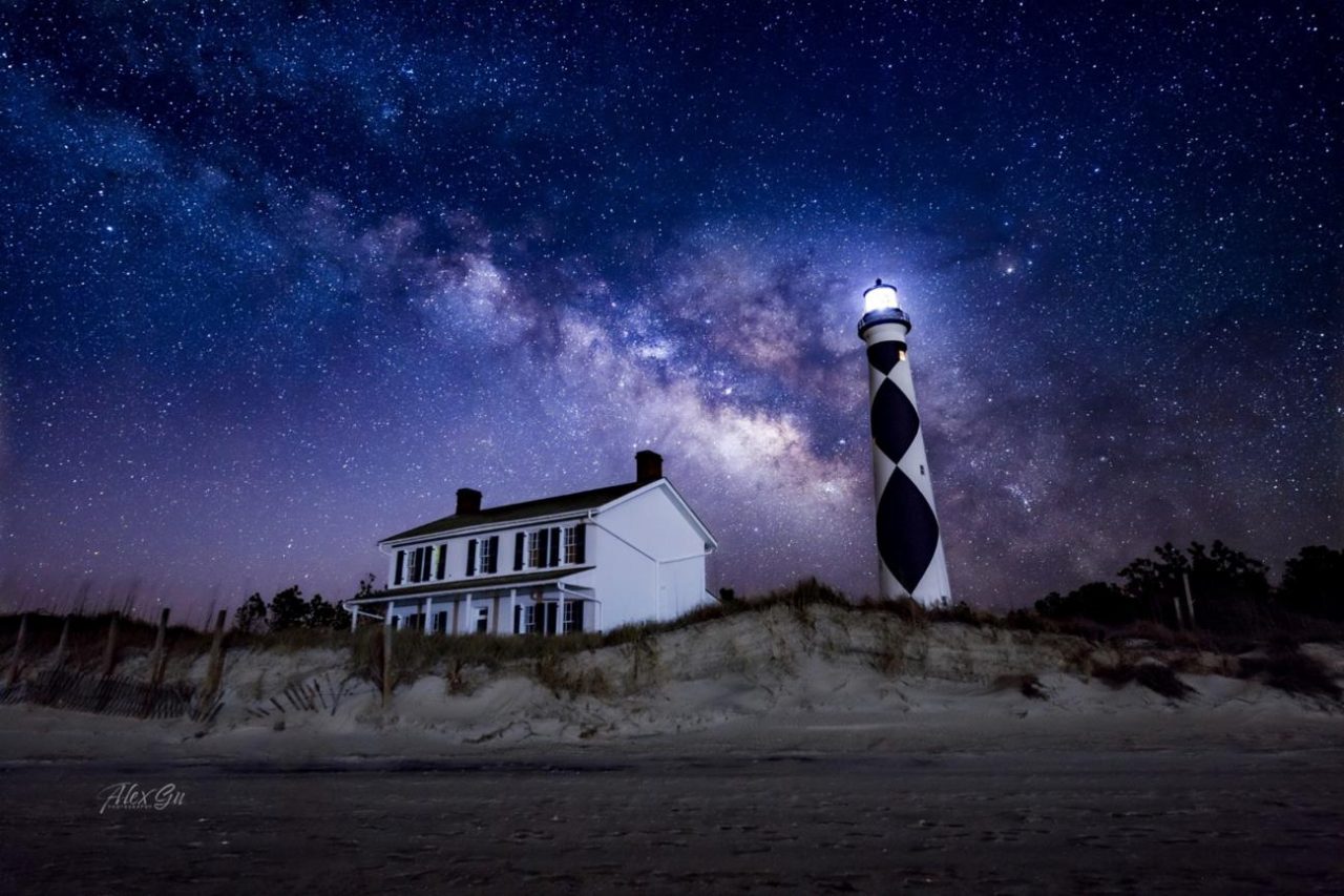
Cape Lookout National Seashore has been certified as a Dark Sky Place, the first in the National Park Service on the Atlantic coast to receive this certification. The popular Cape Lookout Bight anchorage is practically in the shadow of Cape Lookout Lighthouse. In rough offshore weather, cruisers with shallow draft may choose to access the anchorage via Taylor Creek and Barden Inlet which separates Shackleford Banks and Core Banks. See Dark Sky Park.

Cape Lookout Lighthouse under the night sky. Photo: Alex Gu/Crystal Coast Stargazers
Cape Lookout is now a certified International Dark Sky Park
CoastalReview.org
Click Here To Open A Chart View Window, Zoomed To the Location of Cape Lookout Bight
It makes sense, as residents have advocated for months — more than 3,000 signed a petition — to adopt strict speed limits and keep power boats from generating oversized waves big enough to swamp smaller boats, knock paddlers off boards and endanger visitors looking to enjoy a serene weekend on the water.
Editorial: Cut speed limits where boaters, swimmers share Intracoastal – Palm Beach Post
Palm Beach Post
EXUMA PARK MOORING FEES
Up to 39’11” – $30 • 40’ – 49’11” – $40
50’ – 59’11” – $50 • 60’ – 69’11” – $80
70’ – 89’11” – $120 • 90’ – 119’ – $150
120’ – over – $170
Landing Fee – $10/pp (visitors9not on mooring)
ANCHORING FEES (Daily)
under 90’ – $0.50/ft
over 90’ – $1.00/ft
Check www.bnt.bs for latest info.
Shame that the cruising fees have double , Don't mind the park fees.
Searching for clues about one of the most important forces in the planet’s climate system: a network of ocean currents known as the Atlantic Meridional Overturning Circulation (AMOC).
The Atlantic’s vital currents could collapse. Scientists are racing to understand the dangers.
MIT Technology Review
Gulfport Municipal Marina, A CRUISERS NET SPONSOR, and the City of Gulfport always have a full calendar of events for all ages. The marina and harbor, found on the northern shores of Boca Ciega Bay, are easily accessible from the Western Florida ICW, just north of Tampa Bay.
Click Here To Open A Chart View Window Zoomed To the Location of Gulfport Municipal Marina
Click Here To Open A Chart View Window Zoomed To the Location of Gulfport Anchorage/Mooring Field
David Cecelski found this group of photographs at the State Archives of North Carolina in Raleigh. They were taken in Salter Path, a fishing village on the North Carolina coast, probably in 1938 or 1939.

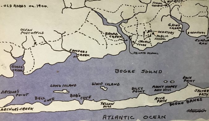
Map of the western end of Bogue Banks and Bogue Sound around 1900. From Kay Holt Robert Stephens 1984 work, “Judgment Land: The Story of Salter Path,” vol. 1.”
Our Coast’s history: The early days of Bogue Banks
CoastalReview.org
Be the first to comment!