CRUISERS NET
Cruisers Helping Cruisers
Comprehensive cruising resource for the Intracoastal Waterways
from Norfolk to the Northern Gulf and Bahamas.
from Norfolk to the Northern Gulf and Bahamas.
FREE to use due to the generosity of our sponsors - please patronize them
Summer Newsletter 2026

Atlantic Yacht Basin, A LONG-TIME CRUISERS NET SPONSOR, is located just south of the Great Bridge lock and bridge at Mile Marker 12 in Great Bridge, VA. If you have wood damage or need a few modifications with the interior or exterior of your boat, Atlantic Yacht Basin has the team to fix it right.
I have used them many times for both repairs and short-term storage during my ICW trips. AYB has a great location and is capable of performing any repairs you may require.

Extend the Life, Value & Beauty of Your Boat With Our Summer Refinishing Special
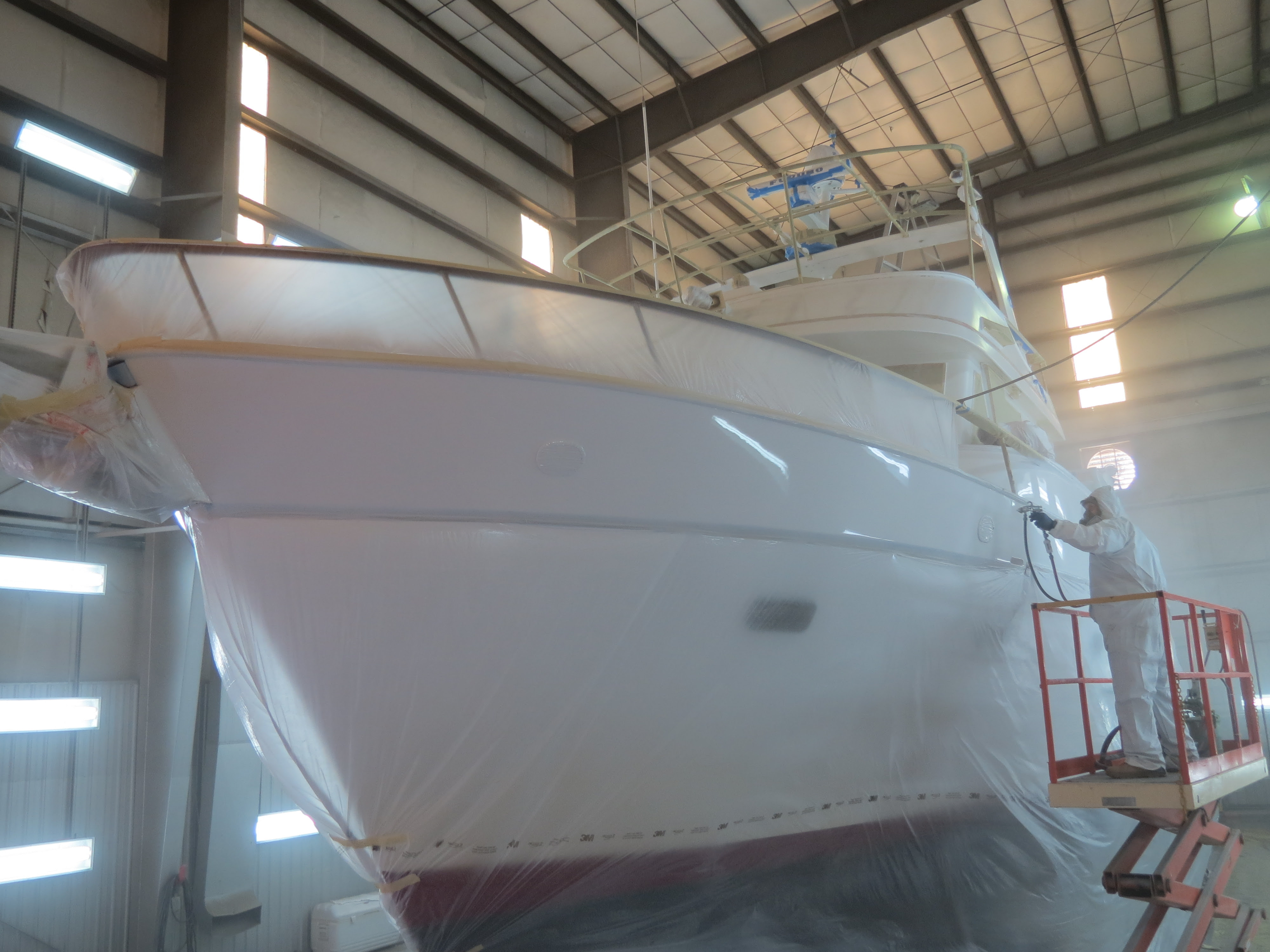
Your boat is both a way of life and a special investment. For some, your boat (and the water) are literally the place(s) you call home. At AYB, we understand why you feel the way you do about your boat and why keeping all of these things in mind is so incredibly important.
That is why we created our Summer Refinishing Special – a discounted offer tailored to your boat and designed to take care of the vitally important deck and hull exterior.
Most vessels have a gelcoat exterior finish that with time will have a relatively poor resistance to sunlight and other environmental factors — causing the finish to look dull, become chalky and even porous. There are very few high quality gelcoat materials available that can hold up over the years, both in terms of looks and structural integrity. Even after you buff and polish your deck and hull, they can still lose their luster quickly, which points to a low quality gelcoat and finish that you need to replace.
PUT YOUR ORDER IN BEFORE AUGUST 31st TO TAKE ADVANTAGE OF OUR SUMMER REFINISHING SPECIAL PRICING.
With a discounted price (based on the size and complexity of the job), we’re offering you boat refinishing that is guaranteed to be an amazing deal – both in terms of its high quality and reasonable cost. And you’ll be protecting the life, value and beauty of your boat while taking care of important work that many put off until it is too late.
AYB’s Paint & Refinishing Crew is especially talented at giving your boat the look and the protection that will guarantee a longer life and greater integrity in any marine environment.
So whether you’re already planning on passing through or are just thinking about the work you’re going to do to prepare your boat for the off-season, this could be the special for you.
Please give us a call toll-free at (800) 992-2489 or local at (757) 482-2141 or drop us a line at info@atlanticyachtbasin.com to take advantage of this special, get a free quote on other work or find out more about our comprehensive range of marine services and storage options.
If you are outside of the area, we can also help arrange transport to our facility or recommend a licensed captain to bring the boat in for you via the Waterway.
We also invite you to find out more on our website at www.atlanticyachtbasin.com, like us on Facebook, or follow us on Instagram for interesting updates, tips, and specials going on at the Yard.
We look forward to helping you have the best boating seasons possible!
Your Friends at AYB


Copyright © 2026 Atlantic Yacht Basin, All rights reserved.
You are receiving this email because you opted to receive information from and about Atlantic Yacht Basin.Our mailing address is:
Atlantic Yacht Basin 2615 Basin Road Chesapeake, VA 23320 USA2 Facebook Likes, 2 Facebook Reactions
Be the first to comment!
The Schooner Surprise: How Out‑of‑Work Fishermen Saved the Revolution – Loose Cannon
Cruisers Net publishes Loose Cannon articles with Captain Swanson’s permission in hopes that mariners with saltwater in their veins will subscribe. $7 per month or $56 for the year; you may cancel at any time.


 Forwarded this email? Subscribe here for more
When all else fails, try journalism.
The Schooner Surprise: How Out‑of‑Work Fishermen Saved the Revolution
Washington Mobilized Massachusetts’ Sailing Talent


Captain John Glover’s schooner Hannah. The author is a professor of History at the University of Tennessee. This story first appeared in The Conversation on June 2, 2026 and is reprinted here with permission.
By CHRISTOPHER MAGRA
George Washington knew his forces could not win the American Revolutionary War without some measure of sea power. “It follows then as certain as that night succeeds the day,” he later wrote in a letter, “that without a decisive naval force we can do nothing definitive, and with it everything honorable and glorious.”
The problem was that the American commander did not have a navy.
As a professor of early American history, I have taught courses on the American Revolution for more than 20 years and have written two books on its maritime dimensions. Washington’s solution wouldn’t come from a French shipyard or a congressional committee. It would come from a group of angry, out-of-work New England fishermen.
Supplying the Army
In 1775, American ground forces managed to lay siege to the British army in Boston, but Washington needed provisions and military stores to sustain pressure on this key commercial hub. Looking out across the Atlantic Ocean, he noticed supply ships arriving in droves from Great Britain – unescorted – to supply the British army in Boston with guns and ammunition.
Unbeknownst to them, the British had already handed the American commander the ships and mariners he needed to capture those resources.
The Sons of Liberty, a network of political activists, had angered the British government by resisting taxes and commercial regulations—from the 1765 Stamp Act, which taxed printed documents, to the 1773 Tea Act, which controlled what tea leaves made their way into North American cupboards.
To punish rebels for their treason, Parliament passed the Restraining Act of 1775, banning New Englanders from fishing on the Atlantic Ocean. Overnight, thousands of skilled mariners—men who spent their lives wrestling 100-pound cod out of the freezing, storm-tossed North Atlantic—were out of a job. They weren’t just unemployed; they were furious. These fishermen left their work tools and ships behind, picked up weapons and joined the siege of Boston alongside American farmers.
Ashley Bowen, who lived and worked in Marblehead, Massachusetts, the principal fishing port in America at the time, recorded in his journal on May 22, 1775, “the fishermen are enlisting quite quick.”
A letter from a French diplomat to the foreign minister in Paris confirmed the news a couple of weeks later: “4,800 sailors seeing they were going to be deprived of their fishing rights, deserted their ships and joined their compatriots under arms.”
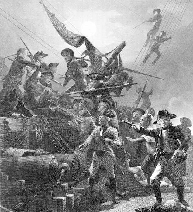
John Paul Jones, known as the Father of the American Navy, commanded sailors during the American Revolutionary War. Creating the First Navy
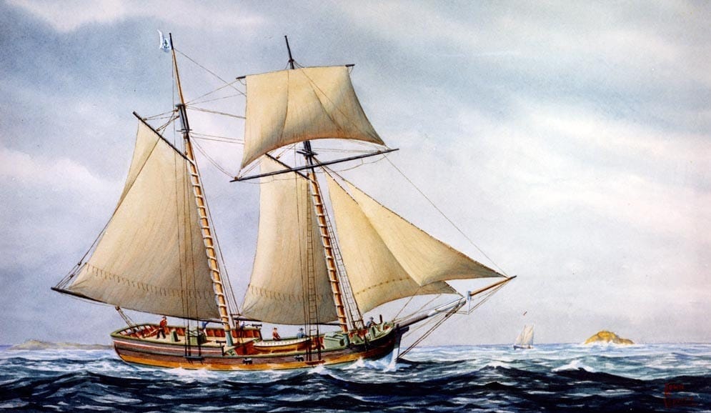
Washington, commissioned by Congress as commander in chief of all American armed forces in June 1775, saw an opportunity. He didn’t wait for Congress to build new frigates. Instead, he reached out to John Glover, a fish merchant from Marblehead and a commissioned officer under his command.
Washington’s plan was simple: Take the sturdy, salt-stained schooners used for fishing and turn them into armed, seagoing predators.
The first of these was Glover’s own fishing vessel and trade ship, Hannah. She wasn’t a formidable man-of-war but a 78-ton workhorse that spent summers at the Grand Banks and winters hauling rum and sugar from the Caribbean. Washington armed the trade ship with a few cannons, manned her with fishermen and sent her out to hijack British supply ships to help his army win the siege of Boston.
Just two days after the Hannah was underway, her crew captured the Unity, a sloop loaded with naval stores and lumber, supplies sorely needed by British forces in Boston.
Between August and October 1775, Washington outfitted a fleet of schooners at Congress’ expense to intercept British supply ships off the coast of New England. These vessels and crews, whose wages were paid by the American government, constituted what many historians consider America’s first navy.
Washington reminded each captain that they sailed “at the Continental Expense.” These orders from Washington and the payments made by Congress made these ships official American warships, operating under the authority of what would become the federal government.
These recruits didn’t need nautical training; they were seasoned seafarers who had battled rough waters and gale force winds. On Oct. 13, 1775, George Washington wrote to his brother, John Augustine Washington, that the fishermen were “soldiers … who have been bred to the sea.”
In 1776, Washington informed the governor of Connecticut, who had asked to draft seamen from Washington’s regiments for his own naval expedition, that he could not spare any. “I must depend chiefly upon them for a successful opposition to the Enemy,” Washington explained.
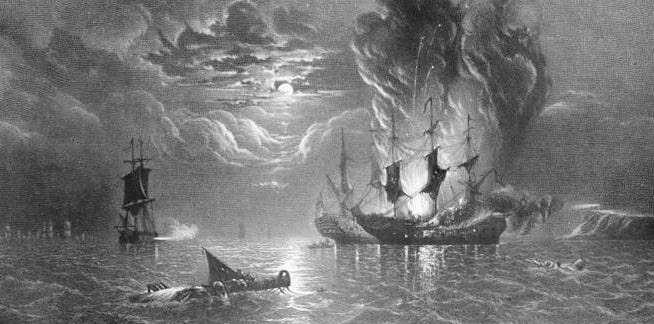
An American navy ship defeats a British navy ship, 1779. Keeping the Revolution Alive
This fleet of converted fishing boats punched above its weight: In the early years of the war they captured 55 British vessels. One such prize, the Nancy, was transporting 2,000 muskets, 30 tons of musket balls and a massive 15-inch brass mortar—supplies the American army desperately needed for the war effort.
Because the British navy was spread too thin, with too few warships available to police the Atlantic coastline, the armed fishing vessels were able to disrupt supply lines and keep the Revolution alive through its infancy. By the time the British realized the threat, the damage was done.
On Feb. 26, 1776, just a few months after Washington launched his fleet, British Admiral Molyneux Shuldham wrote in a report to his superiors that his forces in Boston were low on everything from naval supplies to weapons. What little they could find had to be purchased “at the most extravagant prices.”
The British government had not assigned military convoys to trans-Atlantic shipments at the start of the conflict in 1775. Now, Shuldham recommended arming the supply ships themselves, since valuable stores were being intercepted by rebels in small vessels, “however attentive our Officers to their Duty.”
He concluded the report with an ominous note, explaining that he simply did not have the resources to do everything that was being asked of him – support the army, blockade rebel ports and protect British ships bound for Boston: “I must beg leave to observe to you the very few Ships I am provided with to enable Me to Co-operate with the Army, Cruize off the Ports of the Rebels to prevent their receiving Supplies, or protect those destined to this place from falling into their hands.”

John Glover died in 1797 at age 62. LOOSE CANNON covers hard news, technical issues and nautical history. Sometimes he tries to be funny. Subscribe for free to support the work. If you’ve been reading for a while—and you like it—consider upgrading to paid.
Be the first to comment!
Washington NC JUNE Events, Pamlico River

Keep your calendar clear: Every season in Washington, NC brings something new and exciting. Enjoy local festivals, area concerts, or waterfront adventure.
Click here for the complete calendar: https://visitwashingtonnc.com/events/#/

Screenshot

Screenshot
Be the first to comment!
You Won’t Want to Miss What’s Coming to Elizabeth City – Elizabeth City
Elizabeth City sits at the southern terminus of the Dismal Swamp Canal and has the well-earned reputation of being a transient-friendly town with free dockage for 72 hours.

Summer Starts at the Harbor

The Bassmaster Countdown Is On

Elizabeth City is gearing up for one of the biggest weekends of the year as the Bassmaster Elite Series returns to the waterfront June 11–14! Professional anglers from across the country will compete on our local waters while downtown comes alive with daily weigh-ins, vendors, food trucks, live entertainment, and family-friendly fun during Harbor Festival weekend. Planning to visit? Now is the perfect time to book your hotel, bed and breakfast or Airbnb and experience the excitement right here in the Harbor of Hospitality.
Harbor Happenings
Head to Seven Sounds Brewing Company on June 2 at 6 PM for the Mariners’ Wharf Film Festival featuring Bewitched under the stars.
Catch the River City Skippers this week with:
June 2 @ 7 PM — Kids Run the Bases Night
June 4 @ 7 PM — Thirsty Thursday
June 5 @ 7 PM — Military Night
Enjoy live music downtown with Kaye Baron at Seven Sounds Brewing Company on June 4 starting at 5:30 PM.
Don’t miss First Friday ArtWalk on June 5 beginning at 4 PM featuring local artists, shopping, dining, and waterfront fun throughout downtown Elizabeth City.


RiverCity Skippers Schedule Here!


These are just a few of the upcoming events click here to see more!

Events Community Spotlight

Currently located at 111 N. McMorrine Street, All The Things has become a favorite downtown stop for vintage lovers, treasure hunters, and anyone who enjoys discovering something unique. Filled with antiques, collectibles, handmade goods, and nostalgic finds, the shop offers a fun and ever-changing shopping experience right in the heart of Elizabeth City.
This summer, All The Things will be moving into the former Rochelle Cleaners building at 100 S. Water Street, giving new life to one of downtown’s classic historic spaces. Whether you’re browsing for vintage décor, gifts, or simply exploring downtown, All The Things is a must-visit local gem.


Follow us on social for the latest updates and what’s happening around the county.


Copyright (C) 2026 Elizabeth City – Pasquotank County TDA. All rights reserved.
Our mailing address is:
400 S Water Street Elizabeth City NC 27909
Be the first to comment!
What’s Happening At the Sea Pines Resort (July 2026), Harbour Town Yacht Basin, SC AICW MM 565

Harbour Town Yacht Basin, A CRUISERS NET SPONSOR, is ready for your reservation with newly renovated docks, upgraded electrical service and onSpot WiFi, also a CRUISERS NET SPONSOR. And, as always, numerous activities at the Sea Pines Resort are offered for your enjoyment, as you will see in the Event Schedule below. Hilton Head Island is absolutely marvelous any time of year.

Be the first to comment!
Fishermen’s Village June 2026 Calendars, Punta Gorda, FL

There is always plenty to do around Charlotte Harbor. While berthed at Fishermen’s Village Marina, A CRUISERS NET SPONSOR, you are certain to enjoy visiting Western Florida’s beautiful Charlotte Harbor/Peace River.
Fishermen’s Village JUNE Calendars of Entertainment/Events
June 2026 Sunset Beach Club Calendar
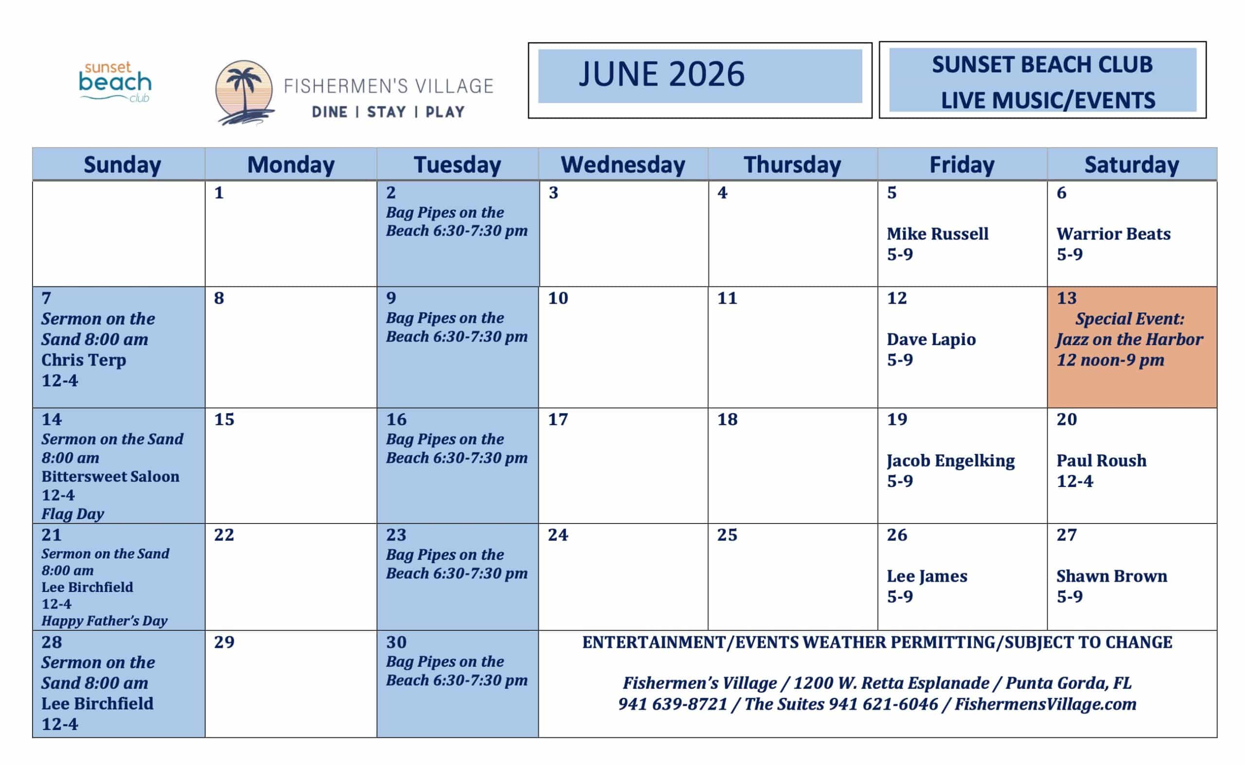
June 2026 Fisherman’s Village Calendar


Special Events & Community Relations941.639.8721
Click Here To View the Western Florida Cruisers Net Marina Directory Listing For Fishermen’s Village
Click Here To Open A Chart View Window Zoomed To the Location of Fishermen’s Village
Be the first to comment!
Portrait of a Mad Delivery Skipper – Loose Cannon
Cruisers Net publishes Loose Cannon articles with Captain Swanson’s permission in hopes that mariners with saltwater in their veins will subscribe. $7 per month or $56 for the year; you may cancel at any time.
Forwarded this email? Subscribe here for more
When all else fails, try journalism.
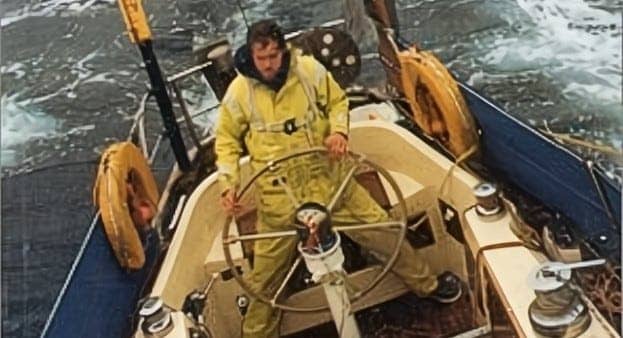
This is the cover shot to Peter Haward’s 1990 book “The All Weather Yachtsman.” Besides being a regular Loose Cannon contributor, the author is a longtime professor of Psychology and Communications. She landed in Vermont in 1987 after a decade of cruising under sail. This is an excerpt from her forthcoming book tentatively entitled “Jenny: A Night Sea Journey.” At one time, Lloyd underwriters regarded her subject, the late Peter Haward of SeaFerries, as the number one delivery skipper in the world.
It’s Force 7, 8 imminent, downwind wing and wing—toward the channel into Liverpool with a Taiwanese-type ketch. Peter Haward is on the foredeck, skeletal in his yellow oilies, a spooky apparition lit by the decklights in the blowing mist. Expletive and his arms go akimbo. He’s lost the halyard, having just dropped one of the jibs to give us a bit more control. It’s sailed up to the top.
He lurches back like a spider on some invisible web and says, “Well well… bosun’s chair is in the lazarette, do be good and fetch it, will you?”
I say, “What? Wait. I mean, it’s not that important, in fact, we don’t even need it. We’ll be in port by morning, at this rate anyway? Maybe it’s not a good idea to go up the mast right now?”
(What I mean is: I myself am NOT going up the mast right now!)
He turned to me with a quizzical expression. That pause. Then: “Oh yes, yes. Quite. But you see, this is between me and my error.” With his accent, it sounds like he’s saying it’s between him and his era. His era, the children of the World Wars.
So, against my own feeble judgement I’m winding him up the mast as we careen crazily at about seven knots with following seas and a wallowing hull and a clumsy motorised self steering doing it’s best, in poor visibility of driving rain (did you know fog has mass?), and I imagine he’s getting quite a bruising, but he’s so determined. I think of the word “indefatigable” and how British it is.
Way up tippety top, a mere suggestion of snapping and billowing yellow, he snags the shackle with a shout of triumph and I let him down as quickly/slowly as possible, taking into account the yawing and accelerations so that he doesn’t get flung out to sea or wrapped so hard on the rigging that any of his old ribs might snap.
We’re finally back in the cockpit and the halyard is snug, and he says he really just doesn’t sleep well if things aren’t Bristol, but he’s going to turn in now, wake him for the 4 a.m. BBC.
At end of the dogwatch I give him a shout, he rolls out his bunk in actual pajamas (which are white with red stripes and a little tasseled sleeping cap. Yes, really.) Takes notes as he tunes in, peering at the chart under a red light.
Comes up on deck for a quick look round, and I muster up my little courage to say, “You know, Peter. I’m thinking that was incredibly stupid of me to, like, collude with you going up the mast like that. I just have to tell you, I’ll be glad when we make port tomorrow because I won’t be party to any such foolishness again. Respectfully. ”
He laughs and says “Oh WELL. You know, we won the wars, on sheer bloody-mindedness. You Americans. My goodness. Grapes in my granola…Hahahah.” His laughter is like a soft cascade of bells at vesper. Always kindly. You can’t stay mad at a man like that.
How We Met
I’ve landed a job making sandwiches for the yacht crews at Cowes IOW race week. In exchange for a sweet little flowery attic room and board, I rise early to begin filling orders in the galley kitchen of the Old Solent Inn, thanks to Lindy Chisnell who took me under her wing.
Each boat in the race has a list of the things that the crew is hankering for that day, and I assemble them one by one, layering the tomatoes, lettuce, various meats and cheeses and fillings and relishes, all on thick fresh bread rolls, wrapping them in wax paper, labeling each one by crew and boat names to be picked up near to noon by someone with a launch.
One day, another guest at the Inn tells me her marital woes as I work, and she even weeps a bit, so I hand her a napkin, some of her tears wet the bread even so. She says how remarkable it is that someone so young as me could bring this out of her. I just listened, that’s all. I wonder if life has to become so complicated and if there’s any avoiding that.
‘I Need To Act Younger’
“You just go mucking about in the low tide on your free time, that’s no way to be young and carefree! I’m sending you to the Royal Yacht Club Ball, Prince Charles will be there! My old friend from London is looking for a companion, we’ll dress you up! It will be fun!”
Her old friend is a very fussy fellow who should remain a bachelor and order his eggs just so, but he’s game to go, so I surrender and Lindy orders her daughters to go gather honeysuckle from the garden and pulls out a Greek sort of drapey off-the-left-shoulder dress for me, the girls all gasp and simultaneously critically assess ( a thing girls excel at doing), and the only problem is my big, big feet. I have no shoes to suit.
Lindy gets on the horn and calls around to everyone on the Isle of Wight trying to find a suitable pair of slippers for size 10 gunboats but comes up empty handed which makes me feel a bit more of a freak as the girls continue to drape me with sweet smelling honeysuckle in my hair and we decide I will just have to go barefoot and take tiny little steps. Ha!
Panic makes your brain stupid but your feet smart. Trust your feet.
Well, my Prince never shows up after all, and my date is dismayed that I roll my own cigarettes (blue packet, Gauloise that smell like burning galoshes) sooo, that’s out.
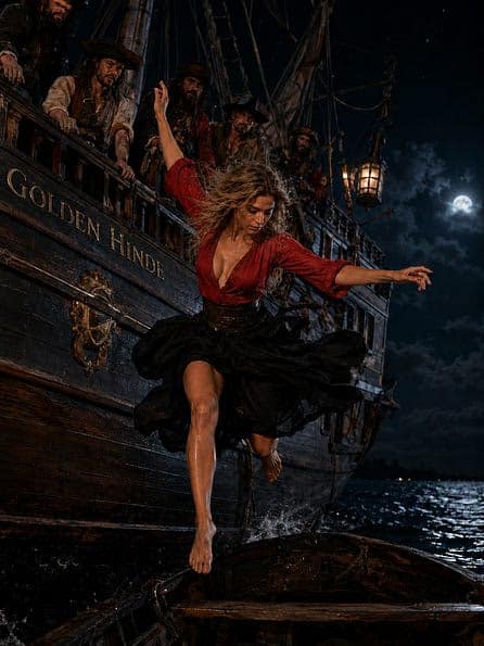
So, then Lindy, never one to be deterred, next day announces, “You’re going to the Pirate party on the Golden Hinde!” and dresses me in a red wrap top and a long black billowing skirt. It’s okay that I’m barefoot for this occasion.
On the Golden Hinde, everyone is drinking heavily and getting way too much into the pirate role for my taste, so as the last launch is leaving at 10 p.m. I leap from the deck to the launch, landing—in a swirl of skirts—very luckily, by some instinctive impulse, on the broad gunnel, to great astonishment, not least of which is my own. Panic makes your brain stupid but your feet smart. Trust your feet.
“The flying pirate.” The next day, last day of the race week, as I finish wrapping up the lunches, Lindy busts in all excited to say she’s had a messenger from the harbor: Peter Haward, the captain of the replica of Sir Frances Drake’s famous vessel, requests an interview. Whatever that means. So I go. I have no other plans or actually even the money left to leave the island, though I haven’t told anyone as much.
The launch driver is staunch and still traumatized by my earlier performance, so I try to make a little conversation. I say “Lister? 12?” He is stock-still impressed. All he says is “yes!” but it is very satisfying for both of us. It was easy. I would know that sound anywhere, because it’s the same as my father’s Dutch steel sloop had long ago. Lug, lug, lug. Once you know it, you know it. Once you’ve bled it, you know it. Workhorse.
I’m curious about this fabled “Peter Haward, captain of the Golden Hinde replica,” which he has brought from Japan enroute to its historical homeport of Poole. Someone whispered that he had brought the famous J-Boat Shamrock across the Atlantic, and someone else had whispered of yet another feat…Everyone is lined up on deck as if for inspection, and I feel as if I’ve walked onto a bizarre movie set. Most of the bedraggled crew have volunteered at various ports of call along the way.
There is one paid crew member, a stout young fellow named Clive from Devon. He knows the boat pretty well and stands next to me to whisper a few tips about what we are doing standing here on deck in the drizzle like this. He says “Peter likes to meet everyone and see who has deserted since last call.”
So, I am a little surprised by the sight of an elderly man, stooping, very thin and tall and gangly, emerging from the bridge deck. Sort of a mix of Errol Flynn and Ebenezer Scrooge, with a retinue of the engineer and the cook, he walks up and down with his head nodding and hands behind back, an occasional handshake, chatting amiably in an absent minded way.
When he comes to me he says “Ah! The Flying Pirate! I’d like to hire you for this next final leg, if you’re willing. A few days to Poole. Clive will show you the ropes.”
Well, sure. It beats swimming. I whisper to Clive “I don’t know ANYTHING about square riggers!? What everything is called!” He says, “Don’t worry about it, neither does Peter! He’ll just point vaguely and say to grab that little line there or that bigger one!”
Cowes to Poole
We get appropriately hung up in irons off the Needles, unable to beat to windward in a calm, and drift around haplessly like a ghostly galleon, but eventually we make our way on. No drama until the big hullabaloo ballyhoo Whoopty-Do-Daw Day when Clive and I must endeavor to earn our biscuits by climbing up the top and making dockside under sail. That’s fine, because it’s calm and really all just for show, the engineer has the engine running quietly below decks, as the band plays and the people three deep on the quayside await this historic return.
Before we came into the harbor, Clive went down on a plank along side to scrub away the salt and brine and make the hull shine with buckets of fresh water. He’s very game. The rest of us motley crew untangle festoons of little flags and burgees to fly from the stays and shrouds, which might have spelled disaster or victory or captives aboard or beware quarantine, rabid rodents. Who knew? Nobody. It was purely decor.
We hear the brass band playing and Peter gives us the signal and we scramble up the ratlines and begin, topsails first, furling as fast as we can, making it smart and snappy as if we had done this all our lives, descending to the next and the next, scrambling to the foremast to repeat the feat, but WTF!
Our feet and hands and hips and anything bodily in contact with the rigging and wet foredeck tingle as electric shocks animate us, like cats on a hot tin roof, with every footafall.
We scuttle and hop and scurry trying to find relief on the wet rigging and decks. Everything we touch is electrified. We look at each other with scurvy eyeballs wide on the yards that we leave a little wee bit sloppy under the circus dances and scrambling to decks hoping for relief but there is none as our hair stands on end, and I think it’s a good thing I’m getting paid for this. If I survive it.
There’s a short somewhere in the electrical system, we dance a weird modern choreograph, but then the engine cuts out, the current stops, we puppets stop hopping. Thank God!
But then we have to ghost into the dock gliding just under the remaining sail.
Peter acts as if it is all to be expected, as if to plan. Waving a thin hand and smiling generously. Clive and I start giggling almost uncontrollably. This could’ve been such a disaster. Yet we pulled it off! The people cheer and clap, children hoisted on their fathers shoulders, babbies all goggle eyed, because they alone understand our weird dance on deck, and the women wiping their eyes with little kerchiefs! The band plays, brass.
‘Neriad of Menai’
I’m very pleased and honored to collect my pay next day, and Peter says, “I don’t suppose you’re available to help me out with another delivery, are you, perhaps?” Well, why not. My pay is barely enough to get me back to London—and then what? I’m not ready to use up my Freddy Laker Discount Airlines return ticket to Miami just yet.
It’s a Taiwanese ketch, Neriad of Menai, lots of carved wooden trim, and we need to get it to Liverpool within three weeks. My first task is to take out all the sails from the hold, flake, inspect, and rig them, ditto the running rigging, and then go get provisions and prepare some breakfast for Peter.
I get what we’d call granola in the states, but he calls it oats, and if it’s cooked, it’s called porridge, which sounds very unappealing to me. Like something you’d eat as a punishment if you were an orphan in a Dickens novel. If anything slightly crunchy textured is added, it’s called Meusli. Swiss knife of possibilities right there.
For a little diversion, I put green and purple grapes into it with a bit of cream and some brown sugar. Peter is astonished by this. A strange reaction, I thought. He giggles every time he spoons up a grape, it’s as if he’d never met the fruit before. He talks to himself, very amused. I wonder if he’s daft. He wonders if I am. No, check that: He’s quite sure that I am. But he’s willing to indulge me. He says “Raisins would not be unexpected. But grapes!” He chuckles as he eats.
The boat seems a little neglected but not too bad, more sort of a day sailing neglect than anything pathological. I ask Peter how he got into this business. He is evidently the original.
He says he had come home from The War and he and his best friend wondered what they should do next. Sailing sounded appealing.
So, they put an ad in the newspaper offering to ferry anyone’s vessel from anywhere to anywhere. He claimed they had little to no experience but were fairly confident they could pull it off. So, their first assignment for a delivery was “rather a large boat, a ship, actually, but not officially.” Whatever that means.
“We jolly well got it down the river and out to sea and headed in the general direction of our destination and when we saw we’d arrived at the next outlet, we had no idea how we’d get up the channel. Fog, tides and so forth. I got on the radio and wouldn’t you know, they sent out a pilot who brought us in quite neatly. Nobody ever knew. After that we studied up and the rest, well…”
We were supposed to depart the river in the morning. But as I slept in the foc’sle, to the eerie tunes of the wind in the rigging, and the ships bell rang 3 a.m., Peter called out to wake me, “I’ve been listening to the weather report. It’ll only be worse tomorrow. So, let’s go now.”
Right? It’ll only be worse out there tomorrow, so let’s go out there now. Get ahead of it.
I will never forget this philosophical pronouncement coming as it did in a howling gale up a raging tidal river in Poole. Every single cell in my slumbering body wanted only to snuggle deeper in my mildewed coverlet. But no. We must go. Now. So we did.
Crisis of Faith
We are passing by The Beaks. The wind has abated to chilly and brisk, and the sun is bright, and the tide is against us now. Peter says, “What say we get a bit of a lift from the iron main?” and goes to turn on the engine but the key snaps in the ignition. Soon there is the smell of smoke and burning insulation from the depths of the bilge aft. He is a little disconcerted, but we sort it all out. We make a run up the bay under sail for Torquay, where he recalls there’s a decent mechanic.
I have noticed that he has a great many scars and scabs and even some fresh injuries to his bald pate from banging his head on things. He doesn’t seem to notice when he does, which tells me that he’s used to concussions.
I’m having a guilty little crisis of faith, here. I’m happy to get into Torbay and search my memory for anyone I’ve met in the vicinity and seize upon Rob and Rindy who do live luckily nearby and do luckily dream of sail, so with Peter’s permission I’m taking the opportunity to invite them to join us for the rest of the delivery.
Barometric ToothAche
Things are much smoother internally for me, having more crew aboard, and now I see the best of Peter’s eternally serene and positively indulgent attitude towards life’s vicissitudes. I learn that apparently, a hot cup of tea is pretty much all you need, and sometimes you wait and a solution, or a pilot appears, and sometimes a dastardly thing goes wrong, but you can still just look and figure it out.
If there’s a fire in the engine room, put it out. If the key snaps in the ignition, just sail. If the weather report is atrocious, get out ahead of it. I start to think there’s some wisdom here for me to remember. In the darkest moments, be of good faith. Providence usually has some kind of sop for you.
But as we round the passage into the Irish Sea and up towards Liverpool’s maw, my jaw starts to throb. I feel as if there is a drumbeat of doom in my cheekbone, growing deeper and louder as the day goes on. The sun shines, the boat is sailing fine, healthy seas abeam, but the feeling of doom throbs with every pulse of my heart. It doesn’t fade away, it just grows more intense until I’m sort of lopsided in my face.
Peter, who habitually seems rather oblivious to the world around him, says, “Oh dear. What’s happening to your face?” I say “ummm. I guess I have a toothache. It’s fine.” He says, “Oh must check the baro!” He’s all excited as if I’ve just told him he won the lottery. He ducks down below and comes back up beaming. “Yes! You’re ahead of the weather! We’ll make excellent time! 12 hours ahead of expected, I imagine!”
This isn’t exactly, “here’s a clove to put in your tooth,” or “try some Panadol,” but it does weirdly cheer me up a little. Like, sure…I’ll take one for the team? He says, “You’re off watch now, go to sleep, while you can. Before it gets much worse. You’ll take the night watch, Rob you’ll step in for her. It’ll be worse later.”
I do sleep a few hours. Someone else makes supper for everyone else, and, when I rise, the wind is howling and the boat is lunging along, fully dark and hissing. Rob is on watch but the motorized self steering is doing the work. The wind is abaft and we’re a little overpowered (in my opinion, which i keep to myself, mostly because I can’t make my mouth work, what with the pain and swelling in my jaw, which I hold in my hand as if that would help.) And, anyway, not like anybody asks me what i think.
So, I go into the cockpit submissively and sit huddled on the windward bench, taking wave after wave cold Irish salt down my neck. Watching the horizon for ships and the compass for our course, my hand glued to my cheek. Rob slips gratefully below shedding his yellow wellies and foul weather gear as he goes.
And then Peter pops up brightly. He says, “Oh dear. Painful? So sorry. Well, you’re on the helm now. Something’s gone wrong with the self steering. Hmph. Never did trust that thing.”
So, now I stand watch in the cockpit with both feet braced far against the combings (these Taiwanese things are WAY too beamy) on an overlarge stainless steel wheel, the compass card jumping like mexican beans in the oversize binnacle, barely able to wedge my feet for leverage, concentrating hard to keep the yaw and the broach under control, wanting less sail up.
We are surfing a bit and I feel the steerage slipping at times as we exceed hull speed and there’s some bickering going on between the tides and the wind causing havoc, hard to judge and it’s such a dark night and now on top of it a wicked dense foggy slam of slabs of goo in the air and I have to keep wrenching my head around to check the oncoming seas and try to anticipate what’s ahead and what’s behind and steer the boat most easily through the surf and surge.
That’s when Peter comes up for a look around and says, “Oh splendid steering, much better than that machine could do. What say we shorten sail now?” I emphatically nod YES. I start to give over the wheel to go up on deck to do the handling but he says “Now now, you’re doing such a good job at the helm, I’ll do the sails,” and goes forward and drops a jib but loses the halyard. Thus, I find myself hoisting him up the top. And he says:
“It’s between me and my error.”
As if he had to settle something. Rob comes up all bleary eyed and asks what’s going on? Peter says, “Oh jolly good, just in time to take over. And fancy that, the self steering is working again! Ha! Wonders!”
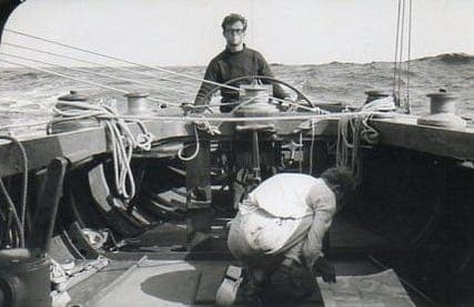
Peter Haward is the guy at the “nav station.” LOOSE CANNON covers hard news, technical issues and nautical history. Sometimes he tries to be funny. Subscribe for free to support the work. If you’ve been reading for a while—and you like it—consider upgrading to paid.
Be the first to comment!
Independence Day Celebration, July 4 – Fishermen’s Village, Punta Gorda, FL
There is always plenty to do around Charlotte Harbor. While berthed at Fishermen’s Village Marina, A CRUISERS NET SPONSOR, you are certain to enjoy visiting Western Florida’s beautiful Charlotte Harbor/Peace River.
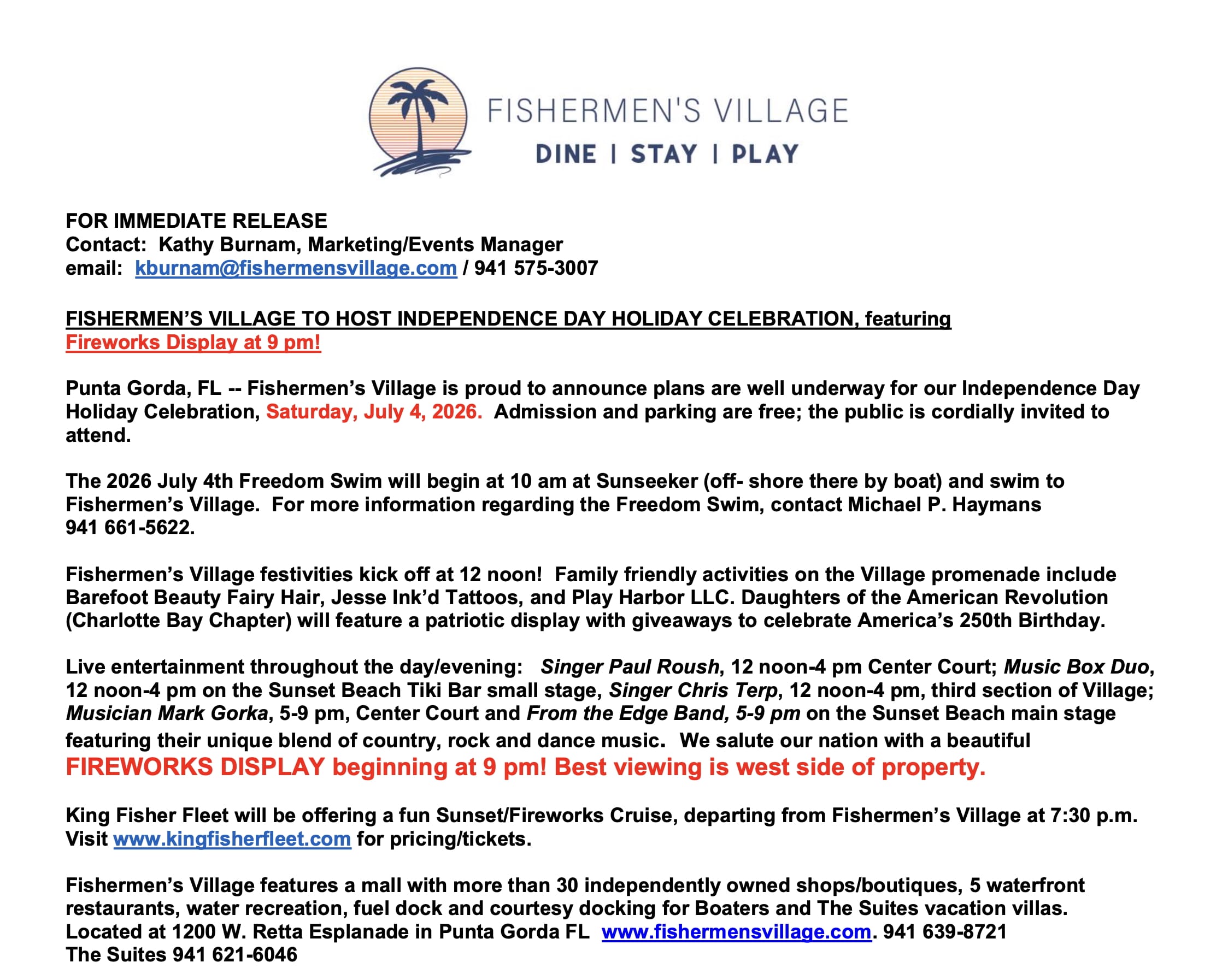


Special Events & Community Relations941.639.8721
Click Here To View the Western Florida Cruisers Net Marina Directory Listing For Fishermen’s Village
Click Here To Open A Chart View Window Zoomed To the Location of Fishermen’s Village
Be the first to comment!
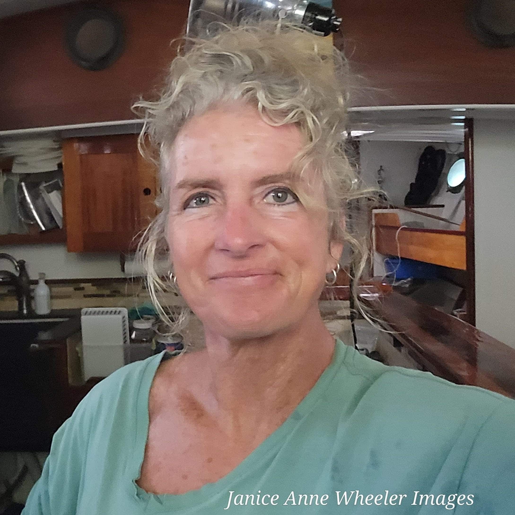
ANTIFOULING. THE DICTIONARY SAYS THERE’S ONE MEANING, BUT LET’S BE CREATIVE – Janice Anne Wheeler, Sparring With Mother Nature
Forwarded this email? Subscribe here for more
Welcome back aboard !!— I hope you enjoy this crazy-ass-world dry-humor change of pace. I had a blast creating it! ~J
If you just dove into our very engaging little community, please read SPARS & SPARRING, .….it introduces my wonders and my wanders. & THANK YOU!
ANTIFOULING. THE DICTIONARY SAYS THERE’S ONE MEANING, BUT LET’S BE CREATIVE
Some days I wish I could douse the stuff on humans I come across, hypothetically, of course…just to make them a tad less foul


“ANTIFOULING?” I repeated, full wrinkle between the brows. Another Marine Industry term that made me go hmmm. “Bottom paint,” was the explanation with just the briefest indication of impatience for we raised-on-land folks. “BIOCIDE??” I croaked, “Dual-biocide?” The tree-hugger** side of me was appalled, jaw a tad slack. When it comes to eliminating pests; it’s only the truly dangerous or invasive that I tend to terminate (spiders!); the balance can simply go elsewhere, wander on and play their role.
According to Merriam-Webster: antifouling adjective an·ti·foul·ing ˌan-tē-ˈfau̇-liŋ ˌan-tī- intended to prevent fouling of underwater structures (such as the bottoms of ships), first used in 1853. For you with inclination, find vast information on the history of antifouling tactics compiled by US Naval Institute. They claim knowledge of compositions and methods as early as 600BCE. Fouling has always been a problem.
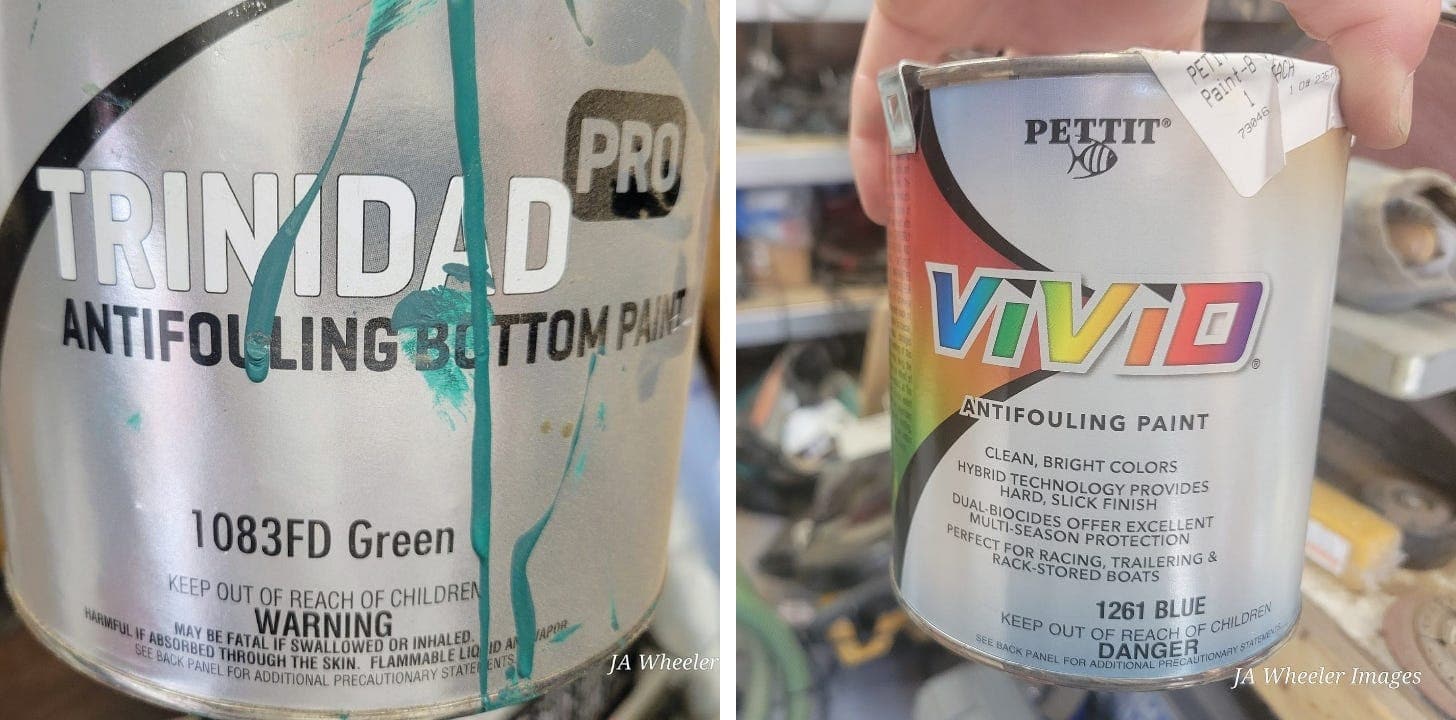 Two common options, main ingredient is Copper. VIVID Blue is for our hard-bottom inflatable dinghy.
ANTIFOULING Paint is used to mediate (not eliminate) the stunning quantity and assortment of marine creatures and plants that are in our seas and can attach themselves to the bottom of a boat at a rate nothing less than astonishing. (Do you remember looking at pond water under the microscope as a schoolkid and being amazed at what was moving?) Live entities whiz around on the tides, are tossed by the wind or simply wander. If these organisms come into contact with STEADFAST’s ample bottom they attach with tenacity that ranges from barely to barnacles. MUST READ about the strength of Barnacle Cement! Six to ten times the strength of anything man has ever made. Mother Nature proves herself once again.
Prior to ever having to scrape that intriguing assortment of life off the nearly two thousand square feet below waterline, in mask and fins, with a two-inch putty knife, I would have showed a distinct aversion to such a product. Now, it’s more of a me-against-the-sea perspective; a steadfast reminder that we are all SPARRING WITH MOTHER NATURE and will continue to do so; I want to live on and in the water regardless of the unseen entities joining me! Bottom paint is effective and imperfect; it does deter attachment and growth. Vessels without any sort of antifouling can become both ungainly and uncontrollable in a matter of months, according to the Navy article cited above.
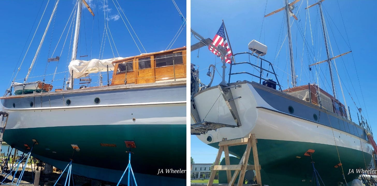 Trinidad Green! Hopefully we’ll get to that namesake! Note the STEADFAST mini-me on the forward deck.
After exploring the practical side of ANTIFOULING, my writer’s brain paddled up a far different creek and thought, well, the world seems to have a bit of foul in it, not just those freeloaders stuck to my bottom. Can antifouling become a thing? A term used for gentle retaliation when someone treats you badly? Instead of confrontation, breathe deeply and imagine treating said individual with a dose of anti-foul.
Is there anyone you have come across that might need a coat? What if we could expose someone nasty or unwanted to anti-foul? They could become the opposite of foul! How delightful! Caring. Helpful. Reliable. Truthful. Welcoming. Friendly.
Personally, I would anti-foul the young woman at the Dairy Queen who told my soft-serve craving sailor that she was “cleaning the ‘effing floor” and was much too busy to fulfill his order. He was the only customer; how appropriate (and satisfying!) would it have been to whip out a container of anti-foul and give her a little squirt?! Maybe our newly conceived antifoul-for-people should even be a standard color—that gorgeous dark greenish-blue— so the public can see which individuals needed a bit of redirection. Anti-fouling is hard to remove, as it should be. We could design a little holster for our Antifoul Applicator so it’s at our fingertips should the need arise. We could provide it to Police officers…presumably they come across even more foul folks than the rest of us. What a peaceful solution. Like fairy dust.
Perhaps your last I-don’t-actually-care-what-
you-want-and-hope-you’re-not- expecting-it-soon server would have improved with a small portion of anti-foul? Or another customer service ‘team member’ who, when asked for something as complicated as paint stir sticks stomped away, found a few and proceeded to toss them angrily on the counter because I had the audacity to ask. She desperately needed a quick coat of anti-foul. I wish I had thought of this sooner! Sprinkle at will and the world is a more pleasant place. How about litterbugs!? Ugh. That is a ridiculous, harmful habit. They definitely need a dash of anti-foul. And the convenience store rushers who cut in and cut over and cut lines, wouldn’t dream of holding the door. Just a little dash of anti-foul? I think so. Some of those traditional, basic, classic manners are a lost art.
STEADFAST requires three gallons of Antifouling per coat, two coats; the current retail is $409 per gallon or $135 per quart. I have never understood the math on how a quart could possibly cost that much and conclude that Manufacturers seem rather foul in their scheme that if you need a smaller quantity, (it’s not an outlying idea), you should be punished monetarily. Or perhaps they don’t realize there are four quarts in a gallon not three as their multiplication might suggest and that their product does not somehow garner a third more value simply when placed in a far more convenient and less wasteful container. A foul deal, indeed.
As I transfer these particular thoughts (no harm no foul) from brain to keyboard I’m feeling a weight of negativity, (…remember these weekly works often develop a life of their own). It strikes me that, right now, the most foul individuals in my world are those who simply DO NOT DO WHAT THEY SAY THEY ARE GOING TO DO. Tasks range from minimal to truly impactful. I see the size of the commitment as irrelevant. If people don’t follow through and hold up their end of the bargain, they become foul. A perfect time for our little holster.
Perhaps some things cannot be fixed with anti-foul, or can they? If we keep the bad stuff from sticking and the unwanted from traveling along with us…that could come in damn handy. Anti-foul rocks.
I do know that there are far more folks in my broad and irregular circle who DON’T need anti-foul than those who do. There’s no better news than that.
Until next week when we will ACTUALLY introduce you to our Bronze Age! ~J
Share SPARRING WITH MOTHER NATURE
** Tree-hugger to me is not political, I simply feel that our natural worlds need protection. I don’t vote along party lines, but for the representer that seems best.

Finally done with the boots! Toes are antifouled for perpetuity. You know what to do, please, so that next time I need a pair of Caterpillar workboots—(we all know there will be a next time because I own a wooden boat), then I will be able to simply ask my sponsor Caterpillar and we’ll discuss their generosity here on SPARRING and life will continue to be grand. Oh come on! A girl can dream! Anti-foul Applicators and NYSE sponsors. Might as well go big and BE NICE. Thanks for staying aboard!
FIRST, CHUCKLE A LITTLE. THEN, RE-STACK THIS POST & ROCK YOUR DAY!
Thanks. You rocked mine. A little sarcasm can be a great thing.
After five days of rain, the front passed. Glory glory. I so appreciate your support of my work. Have a wonderful week!
© 2026 Janice Anne Wheeler
Living aboard Sailing Yacht STEADFAST again soon!
Unsubscribe

Be the first to comment!
BoatUS Foundation State-Approved Boating Course Now Approved in 15 New States

BoatUS is the leading advocate for boating safety in the US and A CRUISERS NET SPONSOR.
Media Contact:
Alisha Sheth
BoatUS Foundation PR Manager
alisha@boatus.com
BoatUS Foundation Expands Free State-Approved Boating Safety Course to 15 Additional States
Online safety course helps boaters meet requirements and build confidence before heading out on the water
SPRINGFIELD, Va. – May 27, 2026 – The BoatUS Foundation for Boating Safety and Clean Water today announced its free state-approved boating safety course has been approved in 15 additional states, giving more recreational boaters access to essential education on safe and legal operation of boats. The course will cover important rules regarding navigation, safety equipment, emergency preparedness, and environmental stewardship.
Boaters in Arizona, Delaware, District of Columbia, Hawaii, Louisiana, Maine, Maryland, New Mexico, North Carolina, Ohio, Oregon, South Dakota, Tennessee, Virginia, and West Virginia now have a convenient free online course option that meets their state-specific boating education requirements.
“Expanding into 15 additional states means more boaters can access boater safety education at no cost,” said Lynne O’Hearn, BoatUS Foundation program manager. “We believe cost should never be a barrier to learning how to boat safely, and these new state-approved courses help ensure more people have the education they need before they leave the dock.”
Designed for completion in two to four hours, the self-paced course offers five interactive lessons that immerse students in a virtual boating experience, guiding them through different destinations while tracking progress. The curriculum is supported by dynamic, video-based learning and concludes with a 60-question final exam with unlimited retake opportunities and can be completed at the student’s own pace. Upon successful completion, most states issue a printable certificate that can be used immediately, though requirements and validity may vary by state.
To take a state-approved free boating safety course in your state, please visit https://boatus.org/free-
courses/free-boating-safety- course/. For more information about BoatUS Foundation’s additional free boating courses, visit https://boatus.org/free-
courses/ ###
About BoatUS Foundation:
The BoatUS Foundation for Boating Safety and Clean Water is a national leader promoting safe, clean and responsible boating. Funded primarily by donations from the more than 740,000 members of Boat Owners Association of The United States (BoatUS), the nonprofit provides innovative educational outreach directly to boaters and anglers with the aim of reducing accidents and fatalities, increasing stewardship of America’s waterways, and keeping boating safe for all. A range of safe and clean boating courses – including the nation’s only free online boating safety course – can be found at BoatUS.org. The BoatUS Foundation for Boating Safety and Clean Water is a four-star charity, the highest rating awarded by Charity Navigator.
Be the first to comment!
How I Rediscovered the ‘Lost Harbor of Christopher Columbus’ – Loose Cannon
Cruisers Net publishes Loose Cannon articles with Captain Swanson’s permission in hopes that mariners with saltwater in their veins will subscribe. $7 per month or $56 for the year; you may cancel at any time.
 Forwarded this email? Subscribe here for more
When all else fails, try journalism.
How I Rediscovered the ‘Lost Harbor of Christopher Columbus’
Modern Science Had Misplaced ‘Port Jackson’ in the Dominican Republic


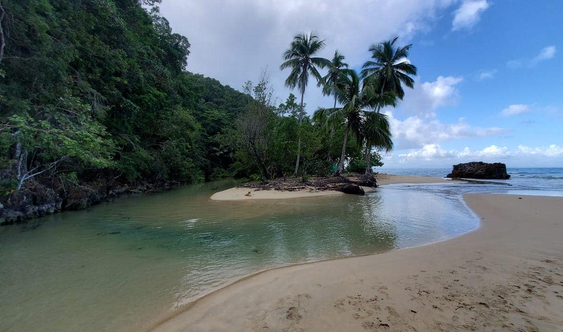
Port Jackson as it appears today. Poring through historical records was an essential first step, but properly researching an anchorage required a boat with a depthsounder. CocoKite, the 28-footer I had hired, lacked a sounder, so I brought a nifty portable model, which transformed the tourist boat into a proper research vessel to probe the coastal waters of the Dominican Republic.
Before becoming a marine journalist, I had toiled for 20 years as a newspaper reporter and editor, a profession wired for a perverse combination of public service and personal poverty. I am also a history buff and a lifelong sailor, specializing in the Bahamas and Greater Antilles. My investigation into a forgotten seaport had the potential to help cruisers move down island more comfortably and safely—maybe even save someone’s life.
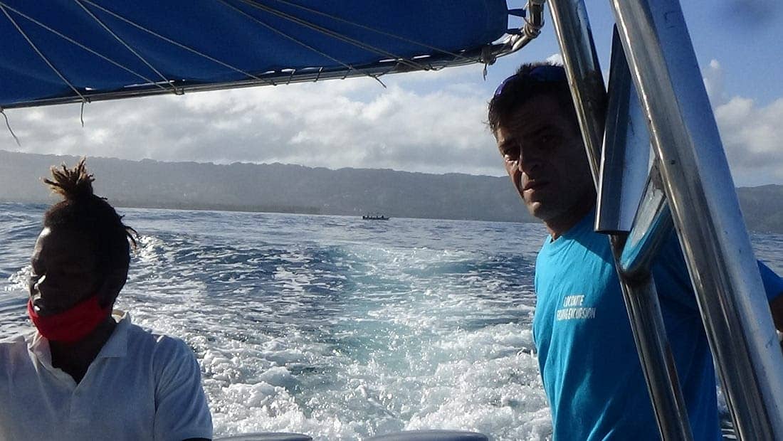
This professional trinity—journalist, history buff, sailor—was knocking along in tandem, as CocoKite thundered westward, parallel to the North Coast of the Samana Peninsula. At the key moment, native guide Francisco Paulino, a fisherman from a local fishing family centered our 28-footer between reefs breaking about 300 feet apart. Paulino pulled back the throttles and slipped the old outboards into neutral.
As we drifted and exhaust fumes rolled over the boat, I dipped the end of a pole into the water, enabling the attached transducer to transmit data to the handheld sonar display, which read 27. Twenty-seven feet was deep enough for a Navy frigate to pass through! Paulino throttled up and into Port Jackson we went.
As he nosed the center console across the placid harbor, the seabed deepened to 40 feet before it became shallow again. We approached to within a couple hundred feet of post-card pretty Jackson Beach, which was shaded by coconut palms. The sounder read 20 feet, a good spot to drop the hook.
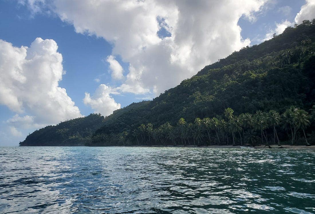
A view from inside the anchorage, facing east toward Point Jackson. Like Leonard Nimoy narrating a low-brow TV documentary, I declared our ragtag expedition a success. The CocoKite crew had rediscovered what I half jokingly had dubbed “the lost harbor of Christopher Columbus.”
I wondered how many passagemakers might have taken refuge in Port Jackson’s protected basin were its existence better known? Though Jackson is a familiar destination for tour operators ferrying vacationing foreigners to its secluded beach, thousands of cruisers sailed by over the decades, never knowing that shelter was nearby.
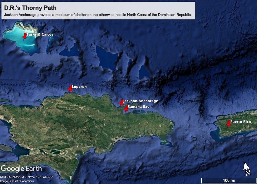
A friend of mine had investigated these waters decades ago. Bruce Van Sant is the quirky gringo author who wrote “A Gentleman’s Guide to Passages South: The Thorny Path to Windward,” in the 1980s, a decade after the stalwart cruisers of the 1970s began transiting Dominican waters en route from Florida to Puerto Rico and the Lesser Antilles. Van Sant’s book discussed the gnarly nature of Dominican waters in great detail.
The North Coast of the Domincan Republic has one of the world’s great hurricane holes at Luperon Bay, which is 88 nautical miles west of Port Jackson. The next decent refuge is 60 nautical miles east of Jackson and up into Samaná Bay. Various anchorages between Luperon and Samaná Bay are open to the north, exposed to thousands of miles of fetch over the North Atlantic Ocean.
When storms from as far away as the Azores send rollers into these semi-protected places, they become death traps for small craft. Those lonesome waters east of Luperon comprise the thorniest leg of the “thorny path” Van Sant wrote about. Bereft of good shelter, eastbound boats face relentlessly contrary trade winds, with waves and current also on the nose.
Christopher Columbus experienced danger in this region, having lost his flagship Santa Maria on a reef off the northern coast of Hispaniola. And yet he must have been feeling that his luck was changing when his remaining ships, Niña and Pinta, made way eastward from Luperon, benefitting from a favorable—and extremely rare—westerly breeze. The year was 1493, and the first Columbus expedition was just a few days from heading back to Spain.
Lookouts atop the rigging spied an island between two headlands against a rising mountain range. The low island capped a mass of coral reefs indicated by breaking waves. What caught the attention of these experienced seamen was the inky blue basin between the island and the beach, and the fact that a wide avenue of dark water indicated a five-fathom entrance.
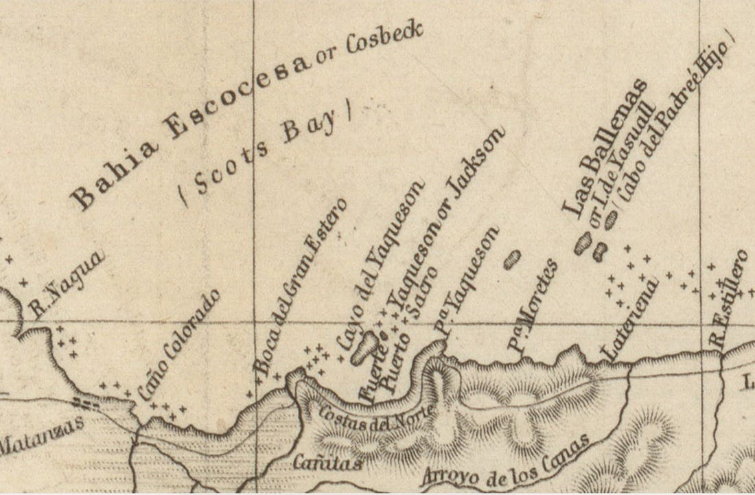
A late 19th century map showed Cayo Yaqueson or Jackson, while retaining Columbus’ name for the place: Puerto Sacro. It was deep and wide enough for a squadron of Spain’s biggest ships. Columbus named the harbor Puerto Santo, the Sacred Port, but he did not take his ships inside. Disinclined to squander his westerly breeze, Columbus piloted his little fleet right past the harbor, cracking along at eight knots.
Two centuries later, French pirates were thick as thieves around Hispaniola. They used the Samaná Peninsula as a place of rendezvous. Mostly they used the great bay on the south side of the peninsula as their base, but they would have been aware of the sheltered anchorage on the north side.
The participant in an 1840s social experiment involving transplanted former American slaves, a man named Jackson called the Columbus island after himself. The port became Port Jackson; the headland on its east side, Point Jackson, and the high hills behind, Jackson Mountain. Eventually, this port was used for commerce, shipping out coconuts and copra. Port Jackson was also an ideal place for ships to take on drinking water, from a gin-clear, spring-fed pool on the beach, which could be seen from the deck of CocoKite.
Now, about that island: While Cayo Jackson is referenced in historical records, it’s no longer present in Port Jackson.
Like mythological Atlantis, it sunk beneath the waves. That event occurred on August 4, 1946, when an earthquake measuring 8.1 on the Richter scale hit Samaná, spawning a 12- to 16-foot tsunami that inundated lowlands. More than 2,500 people were killed.
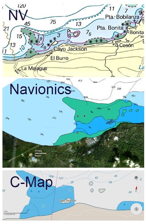
Fifty-two acres of rock and scrubby foliage became a shallow reef sunk three to five feet under. No one told the cartographers, however. Cayo Jackson can still be found on tourist maps, government charts and derivative products from C-Map, Navionics and NV Charts, 80 years after its disappearance.
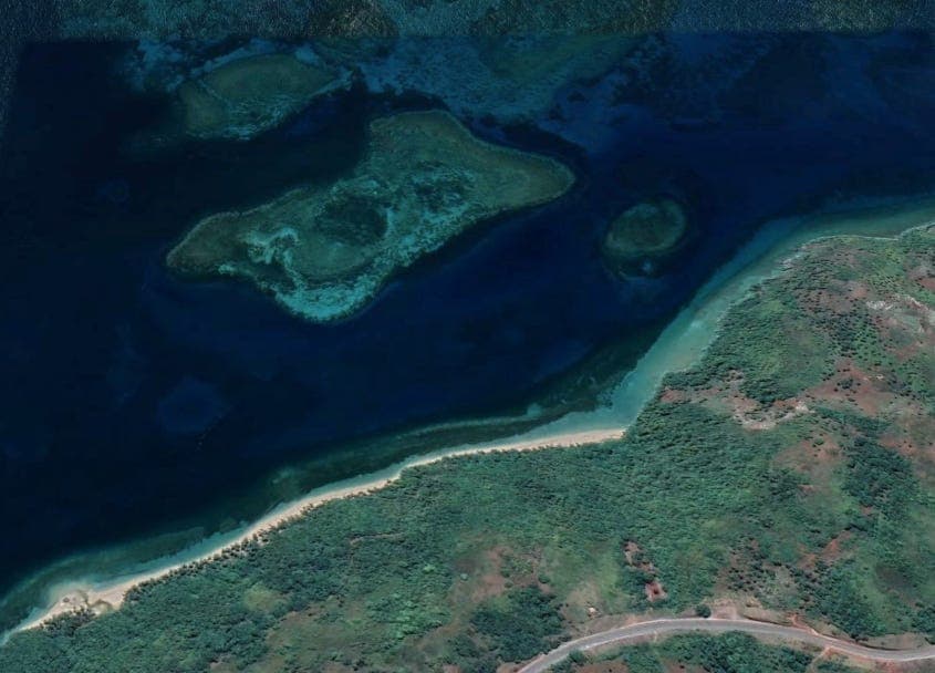
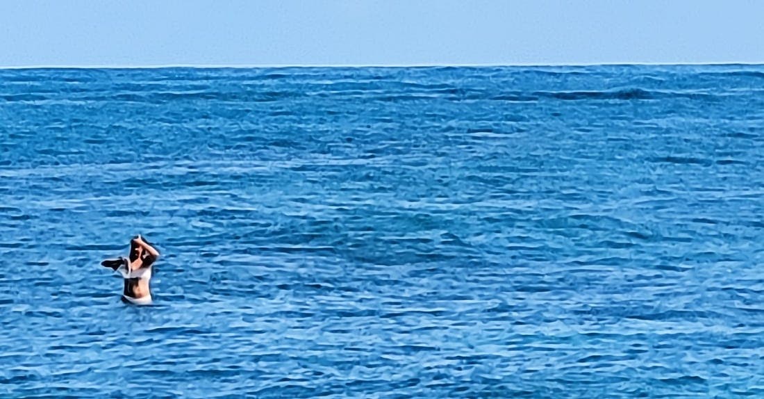
A visiting tourist stands on ground that was once three feet above the waterline, that underwater mass shown in the middle of the top photo. Van Sant told me about the time he went looking for Port Jackson. Charts and U.S. Navy Sailing Directions placed it behind a protective island, but Van Sant didn’t find the anchorage nor could anyone else because they were all looking for the island first. Another impediment was the fact that waters in the vicinity were poorly charted. With reefs all around, exploration without local knowledge was risky.
So, because of a longstanding charting error, modern science managed to misplace one of the first harbors in the New World documented by Europeans.
The loss is unfortunate because even with the island gone, Port Jackson still makes a pretty good anchorage, although my East Coast friends may be skeptical. They wonder how you can have all-around protection without being surrounded by land. The truth is, Port Jackson was never as good as Luperon Bay, which is surrounded not just by land but high ground.
Cayo a No-No
Even before the sinking of Cayo Jackson, the island was so low-lying that it never offered protection from north winds, only from ocean swells. But today, those swells break over a 52-acre reef that sits behind two miles of shallows ranging from just a few feet to 20 feet deep before the drop-off. Unlike their East Coast brethren, voyagers from the South Pacific appreciate this kind of shelter, many having anchored within the coral-ringed atolls of the South Seas.
Reef anchorages are better-than-nothing options for cruisers. To bolster that assertion, I ran it by weather router Chris Parker of Marine Weather Center in Lakeland, Florida. Parker said that as the water gets shallow, there is friction with the bottom, so waves get steep and then break. That dissipates a lot of the wave energy, so the waves are not as steep in the anchorage.
Patrick Florens, owner of CocoKite Tours, is a Frenchman who went native long ago. He was aboard his party barge the day we steered a course to Port Jackson. I asked Florens to begin our approach from Las Ballenas (Whale Rocks in English), which stand prominently about five miles to the east of the entrance. U.S. government sailing directions from 1918 and 1954 recommend using this prominent feature as a starting approach.
I told Florens that I wanted to test the accuracy of these directions. I learned they are not so useful anymore. As already mentioned, the principal point of reference is an island that is not there anymore. Old U.S. Government sailing directions also suggest taking bearings to a white patch on a cliffside. That wasn’t going to work either, because the white patch was gone. probably overgrown with foliage.
We decided to forgo the Navy way. Instead, Paulino took us his way instead. We then documented the approach from the east by taking soundings and recording GPS coordinates. That worked fine for the eastern approach.
The charts, as flawed as they are, suggest a second approach to the anchorage from the west with a controlling depth of 10 feet. But Paulino knew a different way and took CocoKite into deep water beyond the reefs. His route was indirect and difficult to explain. I asked if we could try to find the pass suggested by the charts, but by then it was too late. A hex nut had worked its way off the steering linkage, and the bolt fell into the water. The emergency repair was a bit sketchy, and we lost our appetite for exploration. Maybe next time, we all agreed.
This river empties out into the anchorage, which would have made Port Jackson an ideal place for ships to take on water. As unlikely as it may seem, my quest to find Port Jackson began because the Dominican government opened a new highway along the Atlantic side of the Samaná Peninsula back in 2009. Driving on the Mountain Road a few years ago, I indulged my curiosity about the Dominican island with the Scots-Irish name.
I pulled the car over roughly abeam the GPS coordinates for Cayo Jackson, took a short hike, and there it was—not!
Instead, a greenish shape shimmered just below the surface. And so my mission began.
Columbus gets a bad rap nowadays, but I cannot help but appreciate him as the first European to take note of Porto Santo. His “discovery” happened on January 12, 1493, 462 years before I was born, on that same date. I like to think of the story of Port Jackson as a birthday gift paid forward by the Great Navigator himself.
Patrick Florens and his mate Paulino. FOR A LESS PERSONAL ACCOUNT
Chart Authorities Oblivious Re: Nonexistent Island Along ‘Thorny Path’
·June 9, 2025Read full story LOOSE CANNON covers hard news, technical issues and nautical history. Sometimes he tries to be funny. Subscribe for free to support the work. If you’ve been reading for a while—and you like it—consider upgrading to paid.
Be the first to comment!
Catalina Yachts Auction Includes Nine Boats, Sail and Power – Loose Cannon
Cruisers Net publishes Loose Cannon articles with Captain Swanson’s permission in hopes that mariners with saltwater in their veins will subscribe. $7 per month or $56 for the year; you may cancel at any time.
Forwarded this email? Subscribe here for more
When all else fails, try journalism.
Catalina Yachts Auction Includes Nine Boats, Sail and Power
Butler Family Liquidating All Contents of Closed Florida Factory


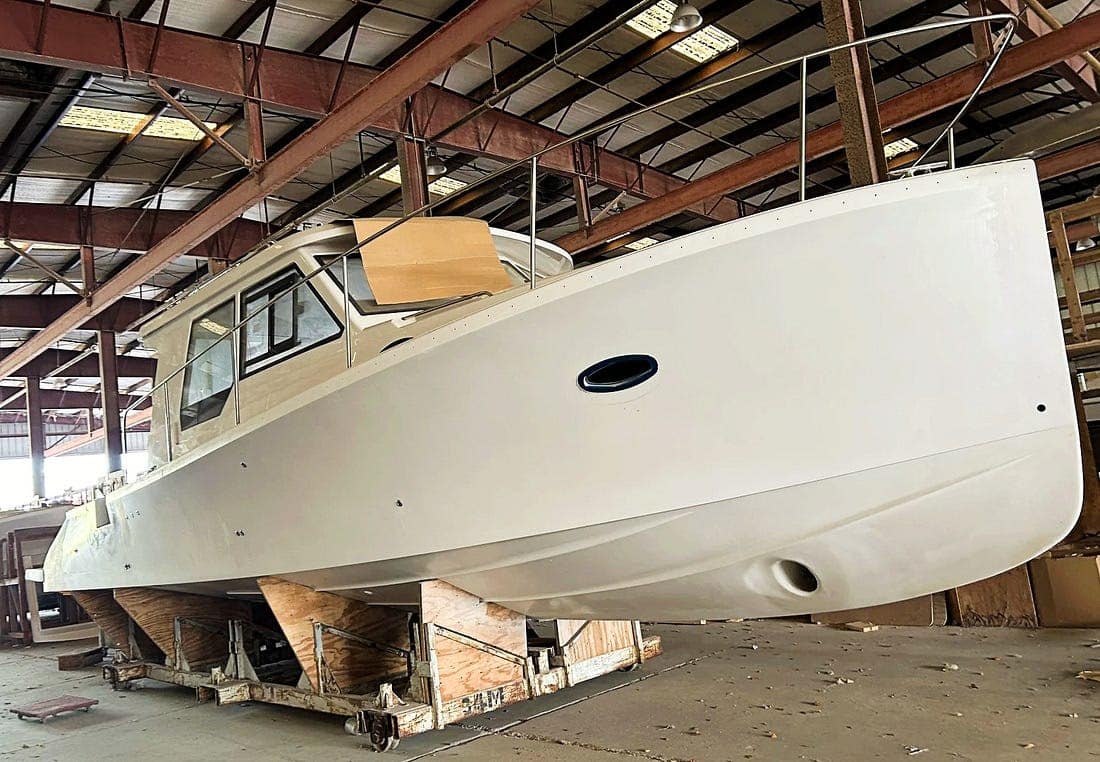
The True North 39 hull and deck could fetch $30,000, for what finished would be worth $1 million, according to Ken Fickett, builder of Great Harbour trawlers. The Catalina 22 has been in continuous production for decades with as many as 18,000 sold. Next month, possibly the final three ever made will sell to the highest bidder. Plus, a third that could be assembled from separate hull and deck parts that will be for sale during the same auction.
The 22 was the first boat produced by Catalina Yachts when the company was founded in 1970 by Frank Butler, quickly followed by the Catalina 27. Catalina of Largo, Florida, was shut down in October when the man who had purchased the company from the Butler estate could no longer make payroll.
Beginning at 10 a.m. on June 9, the bones of Catalina Yachts will be offered piecemeal to the highest bidders. That includes nine boats in various stages of completion, one of them nearly finished. Three more that could be assembled by joining hull and deck parts and another three are hull-only.
The auction will include molds and other tooling for the entire Catalina line. Even so, don’t expect the auction to be a huge money-maker for the seller, according to someone who intends to be there, Florida boatbuilder Ken Fickett, inveterate auction-goer and collector of boat molds.
Ficket, president of Mirage Manufacturing in Gainesville, predicted that the entire auction might net $250,000, but could go higher depending on the stock of materials such as fiberglass, resin and electrical cables—the commodities of boatbuilding.
Besides the 22s—lately fetching around $40,000 new—there is a 316, two 356s and a 426 with bonded hulls and decks. A 386 and 426 could be assembled from existing hull and deck parts. There are three additional sailboats hull-only.
Of the substantially assembled boats, two are True North powercraft, 34- and 39-foot models. There is also a True North 39 hull-only.
Bay Area Auction Services is conducting the four-day auction, which also includes all of Catalina’s tools, equipment and materials left in stock. The auction benefits the owner of the factory property, which was retained by Butler family entities, even as the business itself was sold in May 2025 to a North Carolina boatbuilder.
At the moment the auction house website is displaying 336 photos of Catalina items, but owner Greg Farner said that as the auction date nears he expects that total to grow to a “couple thousand.”
“We’ll be out there next week to get the actual live Internet bidding catalog up,” Farner said. “So we’ll have multiple pictures of each of these models. It should be up by the end of next week.”
Farner pointed out that the sailboats all lack masts, rigging and sails, and none of the vessels have engines. “And that’s another, 100 to 150 grand depending on the size of the boat,” he said.
Farner also said that all the upfront legal work has been done to ensure that auction buyers are undisputed owners of property they buy—the process has taken into account any previous customer payments made for the boats in question.
Gallery
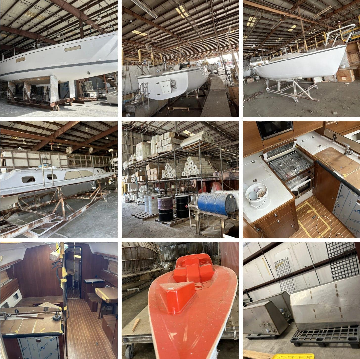 A selection of what may eventually total nearly 2,000 photographs.
A 22 Revival?
Eulogies for the Catalina 22 might be premature, Boatbuilder Fickett said, noting that some enterprising builder might snap up everything it takes to resume production. “You could get all the rights to the 22, all the molds to set yourself up in the Catalina 22 business, and if you spent $50,000, you might be overspending,” he said.
In general, the partially built fleet is worth just “pennies on the dollar,” Fickett said. Which could be a trap for the amateur builder who sees the auction as an opportunity.
“Here’s the problem: If the boats don’t have 100 percent of their fiberglass pieces, now you’ve got to construct those pieces on a one-time basis, and that’s a huge pain in the ass,” he said. “It wouldn’t be much for me to figure that out, but Joe Blow might struggle with it.”
One strategy might be to buy one of the unfinished boats and the corresponding molds, Fickett said, suggesting that a quarter-million-dollars worth of tooling could be had for, say, $30,000.
Sad Goodbye
For some of the longtime Catalina workers, the auction will seem like a funeral, dashing any hopes of a corporate comeback. “It’s a shame that they are letting the company go. We loved working there, even though our pay wasn’t that good,” Lisa Cayce said. “We were all family.”
Hmmm. Catalina Shuts Down Factory ‘Temporarily’
·October 18, 2025Read full story 
Catalina Yachts Owner Evicted from Factory
·October 24, 2025Read full story 
Michael Reardon’s Year of Living Dangerously
·November 5, 2025Read full story
‘Wage Theft’ Decision Against Catalina’s Former Owner
·Feb 17Read full story LOOSE CANNON covers hard news, technical issues and nautical history. Sometimes he tries to be funny. Subscribe for free to support the work. If you’ve been reading for a while—and you like it—consider upgrading to paid.
Be the first to comment!
Cruisers’ Net Weekly Newsletter – May 29, 2026
Cruisers’ Net Newsletter for this week has just been emailed via Constant Contact.
If you want to view the newsletter but are not signed up to receive them automatically, you can view it at https://conta.cc/4nTuyD3 or see it below.
To automatically receive our emailed Fri Weekly Newsletter and Wed Fuel Report, click:Be the first to comment!
Missing Wife’s Boat Had FLIR…So What? – Loose Cannon
Cruisers Net publishes Loose Cannon articles with Captain Swanson’s permission in hopes that mariners with saltwater in their veins will subscribe. $7 per month or $56 for the year; you may cancel at any time.
Forwarded this email? Subscribe here for more
When all else fails, try journalism.
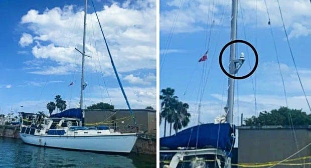
This photo combo from CBS News shows the FLIR sensor mounted on Soulmate’s mast. The latest news in the case of missing cruiser Lynette Hooker is the biggest red herring yet. This is what happens when news sources who don’t know anything about boats and boating are providing information to reporters that are equally ignorant.
These are the headlines:
- FOX News: Missing American’s husband had $33K thermal camera on boat that night and never used it, friend says
- CBS: Infrared camera on sailboat may hold clues in Lynette Hooker investigation
- Daily Mail: Husband of missing woman who “fell” from yacht had thermal camera but didn’t tell cops.
Lynette Hooker went missing on April 4 after her husband, Brian Hooker, said she fell from a dinghy in the Abacos during rough waters. Brian Hooker told police he searched for her but was hampered by the fact that the dinghy engine was disabled because the kill switch went overboard when she did.
Derived from military technology, FLIR marine thermal imaging cameras allow boaters to navigate in the dark, detect unseen obstacles and locate individuals in the water by detecting heat instead of light.
Let’s assume for the sake of argument that Brian Hooker did not murder his wife. I know this may be difficult for some readers.
Hooker’s story is that his wife fell out of the dinghy maybe a half mile to a mile from their anchored sailboat Soulmate. As shown in the CBS photos above, the FLIR camera is mounted on the mast. Using it in the search for Lynette Hooker would have required a fairly time consuming process.
Again, assuming Brian Hooker is not a wife-killer, it probably wouldn’t have occurred to him to paddle his dinghy back to the mothership in blustery conditions, start the engine, raise the anchor and navigate back to the scene of the accident—all the while monitoring the FLIR display for a hot spot.
Plus, the guy may well have been intoxicated after an afternoon of cocktails.
Rather than expend precious time trying to employ a distant thermal camera, the conservative play would have been to stay and try to find Lynette Hooker in the vicinity of where she fell in.
Nor is failure to disclose the existence of the camera necessarily evidence of “cognizance of guilt” on Brian Hooker’s part. Maybe it just didn’t occur to him. Now, if the man had a handheld FLIR camera and did not use it—or disclose it—that might justify those sorts of headlines.
Late Breaking: Husband Arrested in Connection With Wife Lost Overboard
·Apr 8Read full story LOOSE CANNON covers hard news, technical issues and nautical history. Every so often he tries to be funny. Subscribe for free to support the work. If you’ve been reading for a while—and you like it—consider upgrading to paid.
Be the first to comment!
Your Weekend Plans Just Got Better – Elizabeth City
Elizabeth City sits at the southern terminus of the Dismal Swamp Canal and has the well-earned reputation of being a transient-friendly town with free dockage for 72 hours.
Your Weekend Plans Just Got Better


School’s Out, Boats Are In, & Summer Begins


Kick Off Summer in Elizabeth City
School’s out, the days are getting longer, and summer fun is officially arriving in Elizabeth City. From waterfront walks and local shopping to delicious dining and relaxing harbor views, June is the perfect time to plan a getaway to the Harbor of Hospitality.
Harbor Happenings
Betsy is coming! – Step back in time and experience the legendary story of Betsy Dowdy during the upcoming Betsy Dowdy Ride Event on May 30. This unique regional reenactment honors the brave 16-year-old who rode nearly 50 miles through the night in 1775 to warn local militia troops of advancing British forces.
- Live Music: Downtown is bringing the music this week with several live performances to enjoy along the waterfront. Catch PBNJ at River City Biergarten on Thursday May 28, Derek Smith & Jasper Smith at Seven Sounds Brewing Company on Friday May 29, and Jazz Night with James & Connected at 2 Souls Wine Bar on Saturday May 30. It’s the perfect excuse to grab dinner, relax with friends, and enjoy a fun weekend downtown.
- BassMaster Elite Hooked on the Harbor fishing tournament: Excitement is building in Elizabeth City as this nationally known fishing tournament is quickly approaching on June 11–14 at Waterfront Park. Visitors can look forward to daily weigh-ins, professional anglers, local vendors, family-friendly activities, and a lively Harbor Festival atmosphere throughout downtown. We are currently confirming volunteers, if you’d like to be part of the excitement, sign up today! Bassmaster Volunteer Sign Up
- River City Skippers baseball: Summer fun is officially underway in Elizabeth City as the River City Skippers kick off their 4th season in the Old North State League at Knobbs Creek Park. The Skippers bring exciting summer collegiate baseball to the waterfront community all season long.
- First Friday Art Walk: Be sure to mark your calendar for the June First Friday ArtWalk , where downtown comes alive with local artists, shopping, music, and community fun. Whether you’re planning a weekend getaway or just looking for a reason to explore the harbor, June is packed with reasons to visit Elizabeth City.


RiverCity Skippers Schedule Here!
These are just a few of the upcoming events click here to see more!

Events Community Spotlight

Albemarle Queen
Cruise into waterfront fun aboard the Albemarle Queen, one of Elizabeth City’s most unique experiences on the water. Offering scenic cruises along the Pasquotank River and Albemarle Sound, the paddlewheel boat provides a relaxing way to enjoy the Harbor of Hospitality from a different perspective.
Whether you’re planning a weekend getaway, date night, or family outing, the Albemarle Queen offers memorable cruises and specialty events throughout the season. With beautiful waterfront views and a welcoming atmosphere, it continues to be a favorite for both visitors and locals alike.


Follow us on social for the latest updates and what’s happening around the county.


Copyright (C) 2026 Elizabeth City – Pasquotank County TDA. All rights reserved.
Our mailing address is:
400 S Water Street Elizabeth City NC 27909
Be the first to comment!


 June 2nd


 May 28th


Social Media Auto Publish Powered By : XYZScripts.com
Be the first to comment!