Earth Day April 22, 2021
EARTHDAY.ORG is honored that the Biden Administration has decided to convene a global climate summit on Earth Day 2021.

EARTHDAY.ORG is honored that the Biden Administration has decided to convene a global climate summit on Earth Day 2021.
While this issue is framed as a derelict vessel issue, as is often the case, the regulations, laws, and statutes needed for identifying and removing derelict and at-risk derelict vessels are in place. Florida’s FWC and Florida law enforcement agencies have the legal authority and ability to identify and regulate derelict and at-risk derelict vessels in the Florida statutes through chapters 327 and 328. In fact, Florida statues even provide for a Rapid Derelict Vessel Removal process. In addition, Florida statutes clearly gives FWC and Florida law enforcement agencies the regulatory authority to inspect the compliance for a vessel’s sanitation disposal.
We have all seen municipalities that illegally “create” their own ordinance in order to maintain their “slice of heaven”. Gulf Port, Fl, St. Petersburg, Fl, Ft, Myers, Fl…
What do you suppose will occur, when Florida municipalities believe that they now have the authority to regulate anchoring in Florida waters?
Had there been a real effort behind reinstating/continuing Florida’s mooring field program, I believe that the mooring field test program would have greatly reduced the derelict and at-risk derelict vessel issue. The remaining favoritism with anchoring restriction/limitations is nothing short of a “Vista protection act for waterfront landowners”.
If these proposed bills that restrict/limit anchoring pass, there is absolutely no assurance that the ability to anchor will be fair and equitable and that the PUBLIC TRUST DOCTRINE survive.
Your support would be greatly appreciated!
All the best
Fred Ruggiero Jr
This planet is home to everyone and together we hold its health in our hands.
| ||||||||||||||||||||
| ||||||||||||||||||||
|
Researchers conducting a planned University of Florida-led study on plankton in two lagoons of the Florida Keys stumbled upon an unexpected presence in the course of their routine sampling: microplastics.
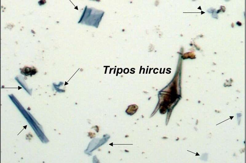
Researchers surprised to find microplastics in Florida Keys lagoons
Phys.Org
Siesta, Lido and Longboat keys among Sarasota-area beaches reporting elevated measures.

Rising red tide levels prompt county advisory
YourObserver.com
Red tides were documented in the southern Gulf of Mexico as far back as the 1700s and along Florida’s Gulf coast in the 1840s.
Edward LePera Thanks Edward. Interesting note .Guess back then the resort market place wasn’t too worried about its impact on local tourism and fishing. Thank you for sharing.
The Golden Ray went aground and partially capsized in Georgia’s St. Simons Sound on September 7, 2019. The wreck of the capsized PCTC has taken more than a year to remove from St. Simons Sound, Georgia. See Cutting Chain Failure.
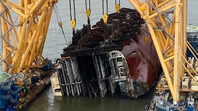
The position of the cutting chain in Golden Ray’s hull on Sunday (St. Simons Sound Incident Response)
Chain Link Breakage Continues to Plague Golden Ray Wreck Removal
Maritime Executive
Below are links to articles and local notices containing advice from experienced cruisers, the Coast Guard, USACE, NOAA and BoatUS. If you have a particularly helpful article or link, please feel free to send it to me.
USCG: Hurricane and Severe Weather Preparedness
NOAA: Preparing for a Hurricane
US Hurricane Trends – Specialty Fuel Services
LNM: USG: Advice on ATONs During and Following a Hurricane
LNM: Tropical Storm and Hurricane Operations at Locks
More from USACE on Tropical Storm and Hurricane Preparations
Hurricane Reminder: High Water in the Waterway Equals Debris in the Channel
Hurricane Season Port Condition Definitions
Hurricane Preparedness Week in North Carolina: Determining your risk
How many hurricanes make landfall in November?
Hurricane Holes in the Bahamas
Traveling the Atlantic Intracoastal During Hurricane Season by Tom Hale
BoatUS: How to Recover Your Boat After a Hurricane
You have to wonder if this new convenience is not going to cause issues for the Coast Guard and for brokers when boats are sold.
Guard Changes
Certificate of Documentation to 5 Years
New rule will spare some boaters a yearly task
SPRINGFIELD, Va., April 14, 2021 — Of the nation’s nearly 12 million registered recreational boats, those owners who federally document their vessels, or about 165,000 boats, will be spared the hassle of renewing their U.S. Coast Guard Certificate of Documentation every year as a result of recent rule change that now makes documentation valid for five years. The move was the result of Coast Guard cost-saving efforts and requirements set forth in the Frank LoBiondo Coast Guard Authorization Act of 2018.
“The change to a five-year documentation period will be a time-saver,” said BoatUS Manager of Government Affairs David Kennedy. Kennedy notes the new rule also eliminates some options that were formerly available.
“Going forward, the five-year Certificate of Documentation is the only option available for recreational vessels as the 2018 Act did not allow for alternatives,” added Kennedy.
Formerly, documentation was $26 per year and boaters could select the number of years, from one to five. The new five-year documentation cost for is fixed at $130. Additional fees apply for initial documentation as well as exchanges. The Coast Guard will not issue refunds if an owner chooses to cancel documentation before its five-year expiration or if a vessel is sold during the renewal period.
Boat owners generally choose to federally document vessels with the U.S. Coast Guard versus the more common practice of state registration, for one of two reasons: the boat was purchased with a bank loan and the lender required it or the owner plans to travel beyond U.S. waters. A Certificate of Documentation is internationally recognized and makes it easier for American vessels to enter and leave foreign ports.
Documented vessels must also be a minimum of 5 net tons, which is about the size of a 26-foot boat. BoatUS notes that net tons are more about (cargo) volume, than weight.
In a related issue, BoatUS continues to advise boaters to be vigilant when renewing U.S. Coast Guard vessel documentation as official-looking vessel documentation renewal notices can lead to confusion and higher costs. Some BoatUS members have received notices that are not from the Coast Guard but rather third-party companies whose name or return addresses may appear similar to that of the official U.S. Coast Guard National Vessel Documentation Center (NVDC).
For more information on documentation go to BoatUS.com/Documentation.
###
About Boat Owners Association of The United States (BoatUS):
Celebrating more than 50 years, BoatUS is the nation’s largest organization of recreational boaters with more than 700,000 members. We are the boat owners’ voice on Capitol Hill and fight for their rights. We are The Boat Owners Auto Club and help ensure a roadside trailer breakdown doesn’t end a boating or fishing trip before it begins. When boats break down on the water, TowBoatUS brings them safely back to the launch ramp or dock, 24/7. BoatUS offers GEICO Marine Insurance policies that give boat owners affordable, specialized coverage and superior service they need. We help keep boaters safe and our waters clean with assistance from the nonprofit BoatUS Foundation for Boating Safety and Clean Water. Visit BoatUS.com.
An ocean protection strategy that targets densely populated coastal areas, rather than ringfencing the most remote corners, could deliver game-changing climate benefits.
Study: Protecting Populous Coastal Areas Helps Fight Climate Change
Maritime Executive
A new mosquito species capable of transmitting disease, Aedes scapularis, has arrived in Florida and shows signs it could survive across multiple urban and rural habitats, posing a potential public health risk.

New Invasive Mosquito Species Found in South Florida
PCT Magazine
A vessel safety check can greatly increase safety aboard your boat. All in-person vessel safety checks follow COVID safety protocols.
How to Get a Vessel Safety Check This Season
No cost, no penalty inspection can improve safety aboard your boat
SPRINGFIELD, Va., March 31, 2021 – No cost, no penalty vessel safety checks, which up until last season were given more than 150,000 times each year by hundreds of U.S. Coast Guard Auxiliary and U.S. Power Squadrons volunteers at launch ramps, boat clubs and marinas, are back.
While COVID may still be with us, both groups are ramping up efforts to get vessel examiners back in the field, responding to individual requests from boaters seeking potentially life-saving vessel safety inspections, as well as encouraging new DIY virtual safety checks. With program sponsorship from the Boat Owners Association of The United States, here’s how boaters can get a vessel safety inspection this boating season.
DIY virtual safety check: A new virtual safety check continues the tradition of no-cost inspections by offering a combination of an easily downloadable virtual safety checklist – the same used by actual vessel examiners – along with online guide that makes it easy for any boater to perform their own examination. To start, go here.
Doing a DIY virtual safety check does two things: It can give first-time boat owners a line-by-line recipe for making their boats safe. It can also greatly increase the chances of any boat successfully passing an in-person vessel safety check. Examiners note that it’s often just one or two items, such as expired flare or a burnt-out navigation light, that prevents a boat from earning a passing grade. The Auxiliary and Power Squadrons also note that some boaters desire to earn a vessel safety check decal to display aboard the boat, which can only be earned through an in-person vessel check.
In-person vessel safety check: While COVID has affected many groups, including the Auxiliary and Power Squadrons, each is endeavoring to get vessel examiners in the field this year. The easiest way to find out if a marina, boat club, or launch ramp will be the site of a scheduled vessel safety check event is to contact your local U.S. Coast Guard Auxiliary or U.S. Power Squadrons. You can also request an individual vessel safety check at cgaux.org/vsc, but note that scheduled vessel safety events may offer the surest way to earn a vessel safety check decal this season. All in-person vessel safety checks follow COVID safety protocols.
###
About the BoatUS Foundation for Boating Safety and Clean Water:
The BoatUS Foundation for Boating Safety and Clean Water is a national leader promoting safe, clean and responsible boating. Funded primarily by donations from the more than 700,000 members of Boat Owners Association of The United States (BoatUS), the nonprofit provides innovative educational outreach directly to boaters and anglers with the aim of reducing accidents and fatalities, increasing stewardship of America’s waterways and keeping boating safe for all. A range of boating safety courses – including 36 free state courses – can be found at BoatUS.org/Courses.

Gulfport Municipal Marina, A CRUISERS NET SPONSOR, and the City of Gulfport always have a full calendar of events for all ages. The marina and harbor, found on the northern shores of Boca Ciega Bay, are easily accessible from the Western Florida ICW, just north of Tampa Bay.
| |||||||||||||||||||||||||||||||||||||||||||||||||||||||||||||||||||||||||||||||||||||||||||||||||||||||||||||||||||||||||||||||||||||||||||||||||||||||||||||||||||||||||||||||||||||||||||||||||||||||||||||||||||||||||||||||||||||||||||||||||||||||||||||||||||||||||||||||||||||||||||||||||||||||||||||||||||||||||||||||||||||||||||||||||||||||||||||||||||||||||||||||||||||||||||||||||||||||||||||||||||||||||||||||||||||
Click Here To Open A Chart View Window Zoomed To the Location of Gulfport Municipal Marina
Click Here To Open A Chart View Window Zoomed To the Location of Gulfport Anchorage/Mooring Field
The state is warning that moss balls, which are used in home aquariums, purchased since Feb. 1 are possibly contaminated with an invasive and potentially destructive fresh water species called zebra mussels. See FWC Invasive Zebra Mussels.
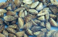
Zebra mussels. Photo: Amy Benson, U.S. Geological Survey
State Warns of Invasive Zebra Mussels
Coastal Review Online
US Powerboat Training together with the nonprofit BoatUS Foundation for Boating Safety and Clean Water are offering an easy way to try out recreational powerboating.
NEWS From BoatUS![]()
Boat Owners Association of The United States
5323 Port Royal Road, Springfield, VA 22151
Read this press release online at: https://bit.ly/3d81gN6
FOR IMMEDIATE RELEASE
Press Contact: D. Scott Croft, 703-461-2864, SCroft@BoatUS.com
Photo Available at: https://www.boatus.com/news-
Take To the Water with
3-Hour On-Water Boat Training Courses
Courses for beginner, experienced boaters and women
held every weekend and Wednesdays through May 30 in Southport
SOUTHPORT, N.C., March 29, 2021 – If you have never tried getting behind the wheel of a boat before, now is your time. US Powerboat Training together with the nonprofit BoatUS Foundation for Boating Safety and Clean Water are offering an easy way to try out recreational powerboating. Five courses, including “Intro to Boating,” “Precision Docking and Boat Handling,” “Open Water Boat Handling,” “Women Making Waves,” and Women’s Precision Docking and Boat Handling” are being held every weekend and Wednesdays through May 30. Course details and signup can be found at BoatUS.org/On-Water. Additional dates are expected to be announced.
Taught aboard single engine powerboats, each 3-hour course is priced at $249 and begins at US Powerboat Training’s location at 606 W. West St. #202 at 9 a.m. or 1 p.m. Class size is limited to four students per vessel, ensuring each student gets sufficient time at the helm under the watchful eye of a U.S. Coast Guard-licensed captain certified to teach the National Safe Boating Council curriculum. The minimum age to participate is 15 years old, and training follows all COVID safety protocols. Early registration is encouraged and there is a two-student minimum for courses.
The “Intro to Boating” course covers centering the wheel, shifting gears, predeparture checklist and station holding, or staying in one place while wind or current effect the boat. “Women Making Waves” offers the same curriculum and is the perfect opportunity to spend a half-day learning boat-handling techniques in a supportive environment.
Both “Precision Docking & Boat Handling” courses cover 180-degree turnarounds, docking on port and starboard, departing from a dock, and using S.C.A.N. procedures to avoid distracted boating. “Open Water Boat Handling” includes utilizing boat trim, displacement and planing handling, ferrying, and emergency stopping.
###
About the BoatUS Foundation for Boating Safety and Clean Water:
The BoatUS Foundation for Boating Safety and Clean Water is a national leader promoting safe, clean and responsible boating. Funded primarily by donations from the more than 700,000 members of Boat Owners Association of The United States (BoatUS), the nonprofit provides innovative educational outreach directly to boaters and anglers with the aim of reducing accidents and fatalities, increasing stewardship of America’s waterways and keeping boating safe for all. A range of boating safety courses – including 36 free state courses – can be found at BoatUS.org/Courses.
AREA CRUISERS NET SPONSORING MARINAS
Click Here To View the North Carolina Cruisers’ Net Marina Directory Listing For Southport Marina
Click Here To Open A Chart View Window, Zoomed To the Location of Southport Marina
Click Here To View the North Carolina Cruisers’ Net Marina Directory Listing For Deep Point Marina
Click Here To Open A Chart View Window, Zoomed To the Location of Deep Point Marina
Click Here To Open A Chart View Window, Zoomed To the Location of Bald Head Island Marina
As the Cape Hatteras Lighthouse approaches its 150th anniversary guarding the Outer Banks coast, its caretakers are exploring 21st century ways to maintain the tower’s distinctive candy-stripe markings.

Dry Ice Test Prelude to Restoring Lighthouse
Coastal Review Online
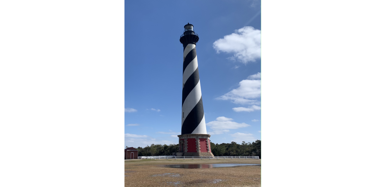
Cape Hatteras Lighthouse To Receive Its First ‘Historic Restoration’
Chapelboro.com


Staniel Cay Yacht Club, a longtime CRUISERS NET SPONSOR and a favorite destination for cruisers in the Exumas, is excited to announce the addition of 21 new moorings balls in the vicinity of their marina.


There are new engine cutoff-device-wear requirements for recreational boat operators as part of the January 1, 2021, passage of the National Defense Authorization Act that included a U.S. Coast Guard Reauthorization.
![]()
Engine Cutoff Devices Now Required
Marina Dock Age
Nippon Yusen Kaisha shipping company has completed a year-long effort working with the Chiba Institute of Technology to collect samples of ocean water for the world’s first large-scale survey of microplastics in the oceans.
NYK Collects Samples for World’s First Large Survey of Microplastics
Maritime Executive
Bottlenose dolphins have learned to adjust with intrusive coastal constructions, a study conclusion recently presented in the Frontiers in Marine Science.

(Photo: David McNew/Getty Images)
Bottlenose Dolphins Adjust to Pollution, Enduring Intrusive Coastal Constructions
Science Times
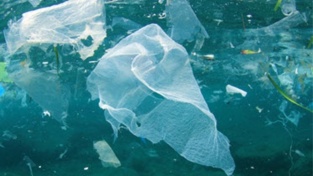
Often helium balloons drift over the ocean and become plastic debris.

A plastic bag tangled around live coral was found on a recent dive. (John Christopher Fine)
Plastic debris is choking the ocean
Sun Sentinel


Be the first to comment!