New Bern Grand Marina, A CRUISERS NET SPONSOR, lies in the heart of downtown New Bern, North Carolina, along Trent River’s northern banks between Trent River highway and railroad bridges. See News for more news from New Bern Grand Marina.
Pump Out Boat Is Being Serviced
The Pump Out boat will be down for maintenance from Friday afternoon to Monday morning. We will not be available to do in slip pump outs over the weekend but our pump out dock is available. Please call the office to if you need to use the pump out station.
Thank you,
Jeremy & Team
Need To List Your Boat…
Please call John Peterson with United Yacht Sales of the Carolinas. John is the marina’s in-house yacht broker and can be reach at (910) 546-5760. John has won numerous awards with United and is now also a broker with Pocket Yachts. Perhaps you’ve noticed those beauties on the side lot next to the dockmaster’s office? If you’d like to view one of his listings or you are considering upgarding, please give John a call today!
TWO MORE BOAT SLIPS WENT UNDER CONTRACT THIS WEEK! They did and our ownership program is growing at a healthy pace. Way to go Thomas…Thank you for all your hard work!
NOW IS THE TIME TO OWN. You can SAVE BIG ON G DOCK…The first three boat slips to sell on G DOCK are being offered at a substantial savings of nearly 18%. That’s the largest discount we’ve ever offered. These slips will sell fast and this price will only be offered for a limited time so call to learn more about our ownership program.
C DOCK – TWO MORE BOAT LIFT BOAT SLIPS WERE INSTALLED THIS MONTH! Boaters love to hop and their boat and go and the word is getting out. New Bern, being one of the favorite fishing and boating communities in eastern NC, is very popular these days. It didn’t take long for weekend boaters to learn they could avoid the long lines at the launch sites by owning at the marina. C Dock offers the only boat lift boat slips in the historic district and boaters are taking note.
RENTAL MANAGEMENT SERVICES HELP YOU EARN $$ WHILE CRUISINIG. We have a number of investors who are buying slips and utilizing our rental management program while owners who choose to make the New Bern Grand their home port so they can enjoy the flexibility of renting their slip when cruising. Most investors agree, the rental income generated is greater than what they are earning in their money market accounts. Furthermore, owners couldn’t be more delighted with the rental income they generate while out and about during their cruising months. And…might I mention, we do all the work for you when it comes to billing. The only thing you need to concern yourself with is watching your rental income grow.
If interested, now is the time to call Thomas.
Tip of the Month: A boat slip on G Dock allows for easy access in and out of your slip, plus you can enjoy the benefits of being located on the marina’s newest dock.
Another impact of the pandemic and another reason to WEAR A MASK!
The National Vessel Documentation Center (NVDC) is closely monitoring the COVID-19 pandemic and, as the situation evolves, is prepared to adjust operations accordingly. During this time of heightened concern, and in response to recommendations from the CDC regarding precautionary measures to help prevent the spread of the coronavirus, the NVDC will be suspending walk-in customer service until further notice.
Customers are reminded that there are several options available for submitting applications and amplifying documentation; via e-mail (.pdf filing), fax, and USPS. One-year Certificate of Documentation (COD) renewals, certified copy of COD, and Abstract of Title A/T requests are available via pay.gov.
Visit www.uscg.mil/nvdc for the latest updates, to download and complete application forms, and to view additional guidance. If you have questions, please contact the NVDC by e-mail, at nvdc.w.webmaster@uscg.mil or by calling 1-800-799-8362.
In the event of facility closures and/or related operational shutdowns, the NVDC will enact measures to minimize any negative impacts to our customers. We recognize that these issues will affect the maritime industry and we plan to provide as much assistance as possible, to ensure that applications are processed in a timely manner.
Vendors and repairmen/women, with identified points of contact and scheduled appointments will still be permitted on premise.
The quarterly Gone Coastal column is one of many ways that the Florida Fish and Wildlife Conservation Commission (FWC) Division of Marine Fisheries Management is helping recreational anglers understand complex saltwater regulations and learn more about saltwater fishing opportunities and issues in Florida.
Renowned ocean explorer Fabien Cousteau has announced his plans for PROTEUS, a project that’s being billed as the “world’s most advanced scientific research station and habitat.”
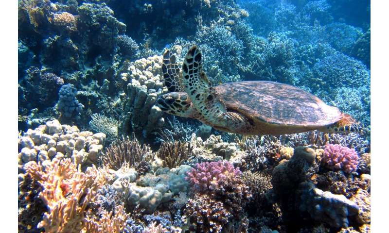
Beautiful and awe-inspiring, National Marine Sanctuaries are home to miraculous wildlife that soar above and swim below the water’s surface. Explore and do your part to help protect these wet and wonderful places.
This excellent facility and CRUISERS NET SPONSOR, Southport Marina, was severely damaged by Isaias. See Hurricane Damage. Experienced cruiser and longtime Looper, Robert Creech, posted this first hand report from his Southport home on AGLCA’s Forum. Thank you Robert!
After a terrifying/anxious night (August 3-4, 2020) with a tornado, power outage, full moon high tide, storm surge, and Hurricane Isaias, upon being told the next morning of damage at The Southport Marina, we walked to the marina and could not find C-life and could barely see C-Breeze III! All of the boats and docks were scattered across the marshes and creeks or piled in the northwest corner of the marina. The only damage at our home was tree limbs and debris. We watched aerial video later that day and thought that we located C-Life, still in the marina. Our power was out for about 48 hours. We were able to retrieve C-Life on Friday, August 7, and C-Breeze III on Tuesday, August 11, and now have both of them back in boat slips in front of our home, with minimal damage, but fixable.
We are very thankful to have so many family members and friends that care about our well being. This has been a very stressful time and we thank all of you for your prayers, coming by to offer help, texts, calls, and emails. Although we may not have responded to all, we greatly appreciate your concern.
Winston and Sue Fowler- August 20, 2020 - 10:59 am
Bob your account of hurricane Isaias passage at Southport is most appreciated. While reading I could almost feel the power of such a storm. We were living in Jamaica when Gilbert ravaged the island, so we can appreciate what you and Kay as well as the wonderful town of Southport experienced. Glad all is going well with your recovery. We will keep everyone in our prayers.
Our thanks to Dr. Mac Ernest for this additional article on traveling the Waterway during the pandemic. See COVID-19 Practices Related to Boating for his earlier article.
Cruising the ICW is a privilege and a pleasure for those of us fortunate enough to have spent time travelling the East Coast by water, creating wonderful memories along the way. As boaters, we appreciate the scenery, the wildlife, and the folks that we encounter along the way. We also recognize the inherent risks of boating whether they be inclement weather, waterway hazards, or boating mishaps. While underway, we constantly scan our vessel gauges for impending problems and the waters for dangerous situations and are always thinking about “Plan B” in case something goes awry.
We are practicing Risk Mitigation as we cruise the ICW and as we navigate the COVID-19 pandemic.
I chose to view our current pandemic situation with COVID-19 as a series of personal risk mitigation issues that I consider, make choices about, and act on every day. As I make those choices—do I cruise this season, do I eat out, do I invite friends to the boat– I realize that the choices I make impact not only MY risk of contracting COVID-19 but also the risk to my family, friends, and people with whom I interact. I understand that my responsibility during this pandemic does not end at the tip of my nose and try to act accordingly. Making these choices involves a basic understanding of the coronavirus (and viruses in general) and how infections result. With this basic understanding, I can then make my choices within my comfort level of risk of developing COVID-19 since everything I do will impact that risk.
A basic understanding of the novel coronavirus can help us make safe and acceptable choices.
A virus cannot move on its own and can only reproduce when it is inside a particular type of cell in our body (or another susceptible host such as a bat). Even if a virus contacts our skin, it will not cause infection because our intact skin is an effective barrier against the virus which does not have the ability to penetrate our skin to begin reproducing. How then does it get into our body to cause infection?
The coronavirus enters our body by way of the mucous membranes of our eyes, nose, and mouth.
-After entering our body by way of our eyes, nose, or mouth, the virus attaches and invades tissues with specific attachment points called receptors. It then begins to divide, reproduce, and invade other parts of the body.
-A favorite receptor for the novel coronavirus is called ACE2 which is found extensively in the lung, heart, and blood vessels (among other tissues). These tissues are particularly suspectible to coronavirus invasion, and are the source of much of the serious disease caused by it including pneumonia, inflammation of the heart muscle, and blood clots and strokes.
-Smoking increases the number of ACE2 receptors in the body which may be one reason why smokers have a higher risk of infection and complications with COVID-19.
How to we protect ourselves from a virus?
If we can protect those entry points (eyes, nose, and mouth), we can minimize our risk of developing a COVID-19 infection. We protect ourselves by avoiding the virus when possible, and limiting the amount of virus to which we are exposed when avoidance is not possible. Here is where risk mitigation needs to be considered because everything we do will either increase or decrease to some degree our risk of developing COVID.
Avoiding the virus would occur only if we remained in a virus-free environment with virus-free individuals. Travelling on OUR boat with OUR immediate family is one way to avoid the virus, but as soon as we leave our boat, bring things onto our boat, or invite others (even other family members who do not live with us) onto our boat, we begin to increase the chance of virus exposure. We can reduce exposure risk by avoiding large gatherings (the more people, the more chance one or more will be infected and emitting the virus), avoiding small confined areas such as small stores or cafes (the smaller the space, the less diluted the air we will breathe and the greater the chance of breathing someone’s exhaled coronavirus). The converse is also true. Being outside in the sunshine (viruses are destroyed by UV light) with a breeze dilutes virus in the environment, making the chance of inhaling virus particles less likely.
We can limit the amount of virus to which we are exposedby washing our hands thoroughly and frequently. Appropriate and aggressive hand washing (at least 20 seconds with liquid soap and water at any temperature) followed by completely drying them will not only physically remove virus particles from our skin, but the soap can also disrupt the surface of the virus, rendering it harmless. Reducing the number of virus particles on our hands means fewer get to our face (and the entry points of our eyes, nose, and mouth) as we unconsciously touch or scratch our face or as we eat. When should we wash? Any time we’ve touched a surface that others frequently use, such as a fuel pump, shore power pedestal, shared marina bath facilities, shopping cart, checkout counter or card reader, we are likely getting exposed to viruses, and handwashing will minimize their transfer to our mucous membranes. Of course, handwashing before eating is a given since our hands are headed for our mouth! Liquid soap is better than foam soap, and even plain water is better than not washing at all.
Since we are constantly being exposed to the coronavirus in the environment, we need to filter what goes out and what come into our eyes, nose and mouth. Masks or proper facial coverings on others and on our face act as that critical filter. We all know people who “sputter” when they talk and have all been the recipient of another person’s spit as they speak excitedly, loudly, and usually “too close for comfort” to our face. If they are infected, the respiratory droplets that these folks which can contain coronavirus can be effectively reduced or prevented by their wearing a mask and remaining at a distance from us (the “six foot rule” of social distancing comes from the ability of these droplets to travel six feet or more). While we cannot always control those around us, we can reduce our risk by maintaining at least six feet of physical distance from others, particularly those who choose to not wear a mask. When we also wear a mask, we not only return the favor to other mask-wearers, but we have an additional filter from some of the droplets that may escape their mask, again protecting our entry points from the coronavirus.
So, we follow all the appropriate guidelines, maintain the 3 W’s (washing our hands, wearing a mask, and waiting to maintain 6 feet of social distance) and work hard to protect the entry points of coronavirus into our body. What next? Cruising during a pandemic gets back to RISK MITIGATION, and how much risk we are willing to accept.
Here are some things to consider as you plan your ICW trip to reduce your risk of virus exposure.
Should you be cruising at all this year? Your age, your health, and your current medications all play a role in how vulnerable you will be if exposed to coronavirus. Talk with your health care provider about your situation if you are over 65, have a heart or lung condition or diabetes, or have immunosuppression from any cause. Not only do you need to decide if you are comfortable with the risk of travel, but you also need to decide how and where you will get medical assistance if you are out of town on your boat and become ill. Take a copy of your medical history, plenty of your prescription medications, and your pharmacy number in case you need a prescription transferred.
If you are not already underway, consider self-imposed quarantine at home for 14 days before departing. By doing so, you will have a lower chance of harboring the virus in your body as you begin your cruise.
How can you reduce exposure to the virus as you travel?
Choose your ports wisely by researching where “hotspots” are occurring and avoiding them when possible. Johns Hopkins University has a website (https://coronavirus.jhu.edu/us-map) that allows you to check cases by locale which may be useful.
Check for local or statewide rules regulating COVID testing and quarantines for areas through which you will be passing or where you plan to go ashore. If required, be sure you have a copy of your negative COVID-19 test results to document your status.
Once in port, search out merchants who follow safe guidelines. In North Carolina, the website www.countonmenc.org has a list of merchants who do so. In other locales, it may be as simple as looking at customers who enter and exit a business and determining whether they and the merchants are wearing masks and are socially distancing when in the business. When you have a choice, shop where safe guidelines are being followed and utilize curb side pickup when available.
Order groceries and supplies on-line when possible. In Oriental NC, for example, the local grocery and other local merchants will deliver to your boat at the local marinas.
After putting up supplies and groceries, wash your hands. When bringing supplies or groceries back to your boat, assume that they are contaminated with virus and avoid placing them on surfaces where you will later prepare or consume food. If you must do so, wipe down the surface with appropriate disinfectant before preparing or consuming food.
Carry enough stores on board so that if you become ill and have to quarantine for 14 days, you can be self-sufficient.
Keep your hands virus-free after washing and while eating by not using your phoneduring meals. Remember your phone is probably one of the most contaminated surfaces you will touch during the day so reduce your risk by putting it away during meals. Wash your hands, prepare your food, set the table, and wash again before moving hands toward your face as you eat to minimize any virus you may have picked up during meal preparation.
While docking, tying up, and signing into the marina, wear your mask to protect yourself and the dockhands.
After docking and checking in, remember to wash your hands before returning to your boat. The intact skin on your hands is protecting you as you hand or receive lines, or sign into the marina, and washing your hands after those activities reduces the amount of virus that you may bring back onto your boat.
When eating out, remember that your greatest risk of exposure is when dining inside. Even when waitstaff wear masks, diners will not and air flow and air volume issues inside a restaurant may allow virus particles that others have exhaled to remain in the air for extended periods of time. This increases your chance of inhaling the virus and becoming exposed. Your lowest risk of exposure is carry-out. You may find a happy medium of risk mitigation by eating outside at a safe distance from other diners.
Only allow immediate family members (those that normally live with you) to stay overnight on your boat. This is a difficult one, because one of the pleasures of boating is having family and friends visit and stay with us. To reduce risk of virus exposure, we must treat everyone not living in our home or on our boat as potentially being infected. Asymptomatic people can and do transmit the virus, and children and grandchildren who come to visit are common sources of infection. Inviting friends or family to stay in a local motel near our marina will lower the risk of our exposure. Inviting them to stay on our boat with tight living quarters and small enclosed spaces will GREATLY increase our risk of exposure with no effective way to mitigate that risk.
Share meals or docktails in the cockpit or on the flybridge remaining at least 6 feet apart. Brief tours of the boat should involve all wearing a mask, and visitors should be asked to wash their hands before entering your boat to minimize virus that they might transmit as they touch surfaces. Meals or drinks outside the boat while socially distancing, especially with a gentle breeze blowing, reduces risk of exposure although masks after eating will lower the risk even more.
Vacate the boat when your mechanic comes to do work. Many marine mechanics would prefer that you do this regardless of a pandemic but these days, he will likely not want to wear a mask while working, and leaving the work area reduces his and your risk. Once he is finished, opening windows for fresh air in the work area will reduce lingering virus particles in the air. Wiping off frequently touched surfaces with an appropriate disinfectant will also reduce virus exposure.
Travelling on the ICW is a pleasure and a challenge.
This season, we have the added challenge of COVID. Assessing the risk of our boating activities has never been more difficult, but constant risk assessment for all of our activities on the water with risk mitigation when possible is key to a successful and healthy cruising season.
Remember to:
Follow the 3 W’s—wash frequently and aggressively, wear a mask regularly, and wait to distance 6 or more feet from others
Protect the entry points of your eyes, nose, and mouth from coronavirus
Mitigate risk of exposure to the virus whenever possible
Thanks for publishing the article. I want to be sure all contributors are recognized: Diana Silimperi MD, Ros Cheetham MSc, and Sharon Stephenson MD live in Oriental NC, are boaters, and all contributed to the article. We hope it helps other cruisers stay safe. Mac
Whether you want to revisit the past, satisfy your curiosities, discover the arts or explore your true nature, you can do it from the heart of the Inner Banks – Washington, North Carolina. Washington City Docks, A CRUISERS NET SPONSOR, has proven to be well worth the journey up the beautiful Pamlico River! Our thanks to Henry Zalegowski for these kind words.
The docks in Washington have got to be seen to be believed, the best town docks I have ever seen anywhere. A lot to see and do in the town of Washington. Henry Zalegowski on an Albin 27, the Donna Lynne
Our thanks to Specialist Erica Skolte for sharing her excellent photo journal illustrating the steps involved with the necessary dewatering of a lock for repairs.
Erica Skolte Public Affairs Specialist Corporate Communications Office U.S. Army Corps of Engineers, Jacksonville District Palm Beach Gardens OFFICE PHONE 561-340-1527 Cell: 561-801-5734 erica.a.skolte@usace.army.mil Twitter @JaxStrong Jacksonville District Facebook: https://www.facebook.com/JacksonvilleDistrict Jacksonville District: A team of professionals making tomorrow better “Keep Calm and Essayons”
Shelter Cove Harbor and Marina, A CRUISERS NET SPONSOR, sits in the center of Hilton Head Island, South Carolina and the marina’s state-of-the-art facilities and comprehensive amenities are complemented by the lowcountry charm of the island. Our thanks to Loopers, Jan and Lee Rychel, for these kind words as posted on AGLCA’s Forum.
A stop at Shelter Cove Marina is a great break. If they [restaurants] are open, several very nice restaurants in the harbor. It’s a quick loaner bike ride to the beach. Jason is one of our all time favorite Harbormasters. We weathered Mathew in Shelter Cove. Jason is a true professional. Never go by without a stop. Jan and Lee Rychel
I second that! Jason and crew and very attentive, I have been staying there for four winters and each year they get better. . I'll b e back next month!
The National Marine Sanctuary e-News connects people to their national marine sanctuaries.
THIS THURSDAY, August 13th, the National Marine Sanctuary Foundation will take you on a voyage to our Pacific marine national monuments and marine sanctuaries.
As a way to raise awareness of the threats facing these vibrant seascapes and ecosystems, the Foundation is hosting a virtual screening of the forthcoming film Hidden Pacific from filmmaker Ian Shive. Mr. Shive will join Kris Sarri, president and CEO of the Foundation, to answer your questions about the experience of documenting these wonders in a Facebook Live event.
This event is part of the Foundation’s Blue Beacon Series, which aims to bring to light the ocean and Great Lakes’ biggest challenges through panels, lectures, and film screenings in order to build communities of support for marine protected areas.
Left: Laysan Albatross at Midway Atoll National Wildlife Refuge. Right: Convict tang and bluefin trevally in a vibrant coral reef at Palmyra Atoll National Wildlife Refuge. Photo credits: Ian Shive.
Hidden Pacific displays the beauty and biodiversity of Pacific marine sanctuaries and monuments in gorgeous, large-format 4K imagery. Because Hidden Pacific will be released in theaters in 2021, we may only allow one-time screening access for this film on August 13th. Then, join the live Q&A event at 7:30pm ET/4:30pm PT/1:30 pm HT.
Ian Shive is an Ansel Adams Award-winning American filmmaker and photographer whose work documents some of the world’s most pristine environments and brings to the public important conservation stories from around the globe. In 2020, Ian Shive launched a new series on Discovery Channel titled Nature in Focus, where he explores our planet as host and executive producer. In 2019, Ian led several expeditions to some of the world’s most remote coral atolls for the giant-screen film, Hidden Pacific, which he directed and produced. Hidden Pacific brings to life in IMAX 3D the vibrant marine national monuments at the far reaches of the Pacific Ocean — thriving ecosystems filled with colorful coral reefs, large colonies of birds, and threatened species that depend on these habitats for survival. Based in Los Angeles, Ian is also the founder and CEO of Tandem Stills + Motion, a leading outdoor media company. For more information, visit TandemStillsMotion.comor to watch Ian’s other videos, visit @ianshivephoto on social media.
Intracoastal Yacht Sales, a long-time CRUISERS’ NET SPONSOR, offers full service brokerage representation from three locations, Wrightsville Beach, NC, Little River, SC and Charleston, SC. You will want to see these new offerings!
This year, for the first time, corals raised by scientists in a lab and transplanted to the natural reefs are primed to join the spawn—a promising milestone for ongoing efforts to restore the ravaged reef systems off South Florida.
Many ICW marinas in North Carolina are closed in order to assess and repair damage from Hurricane Isaias. To phone ahead and find dockage, follow these steps to the Cruisers Net NC Marina Directory.
Hurricane Isaias damaged roofs and toppled trees as it battered the Bahamas overnight and Saturday morning, hitting some areas still recovering from the devastation of Hurricane Dorian last year.


Be the first to comment!