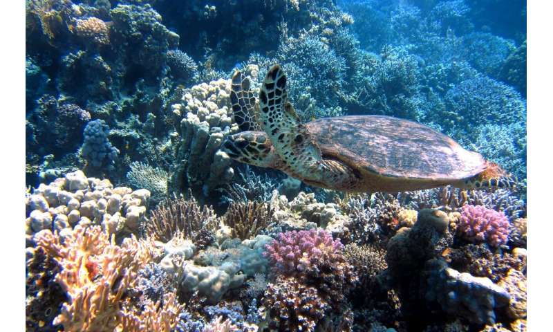
Scientists Race Against Time To Save Coral Off Florida Keys
Over the last 40 years, nearly 90% of the live corals that once covered those reefs have died off.
Scientists Race Against Time To Save Coral Off Florida Keys
Here And Now
Over the last 40 years, nearly 90% of the live corals that once covered those reefs have died off.
Scientists Race Against Time To Save Coral Off Florida Keys
Here And Now
Today live coral on the reefs is 3% to 5%. In the 1970s, coral coverage was 50% to 60%.
Florida Keys coral reef is in critical condition
Florida Keys Weekly
This year, for the first time, corals raised by scientists in a lab and transplanted to the natural reefs are primed to join the spawn—a promising milestone for ongoing efforts to restore the ravaged reef systems off South Florida.
Lab-grown and replanted corals to spawn in the Florida Keys
Phys.Org
Removal of these vessels has resulted in significant improvements in recreational boating access.
County removes derelict vessels from Keys waters with FWC Grant
Florida Keys Weekly
This suspension of mobile pumpout service is not good news to cruisers in the Florida Keys. Cruisers now must rely on land-based pumpout until mobile pumpout is restored. See link below for locations.
FLORIDA – FLORIDA KEYS: Monroe County Mobile Vessel Sewage Pumpout Service suspension.
Effective July 1, 2020 the Monroe County Mobile Vessel Sewage Pumpout Service will be suspended. Vessel owners are advised that waters of the Florida Keys are within a No Discharge Zone and proof of legal pumpout is required. For a list of available pumpout facilities, please visit www.monroecounty-fl.gov/pumpout or call 305-289-2505 for more information. LNM 25/20
There are more than 30 land-based pump-out facilities located throughout the Keys.
This is why people pump overboard!
A referendum was put before Key West voters that sought to dredge a wider channel through the Florida Keys National Marine Sanctuary to accommodate super ships and voters defeated the referendum with an astonishing 74% of the vote.
Opinion: Safer, cleaner ships for the future of Key West
Florida Keys Weekly

Key Lime Sailing Club, A CRUISERS NET SPONSOR, always has very special offers for their visitors! Key Lime Sailing Club is on the Inside Route side of Key Largo. Key Lime Sailing Club is a unique slice of KEYS ENJOYMENT…give it a try and let us hear about your experience.
| |||||||||||||||||||||||||||||||
Click Here To Open A Chart View Window, Zoomed To the Location of Key Lime Sailing Club
The opening of boat ramps in Miami has had a direct affect on the northern Keys as attested in this report. See also Restrictions on Cruisers Transiting the Keys.
FWC Seeing a Large Number of Non-Residents in Monroe County
The Blue Paper
Visitors are currently banned in the Florida Keys and cruisers wanting to move north are finding marinas and dinghy dockage closed to transients, meaning no supplies. These restrictions on water-born travelers in the Keys is being discussed at length on AGLCA’s Forum and summarized nicely by Ben Sanderson, re-posted here with his permission. See also Non-Residents.
True, legally, transients are barred. However, after living here in Marathon for two years, we have never seen the dinghy police. Just say’n for those in real need who have been quarantined for awhile. We’re leaving in the next few days or we would offer to get the groceries. There are several other loopers still here that may speak up and offer. We are all in this pandemic together.
Another idea is to have Publix deliver the groceries to the fuel dock while you are fueling. They make deliveries from online orders. Not sure about Winn-Dixie.
I was super curious so I checked the boat ramp up by us and there were no signs. So I worked my way down to the ramp by Keys Fisheries (bay/gulf side). Saw the homemade signs and a marked patrol vehicle sitting in the lot as they do at all of the ramps since the new regs went into effect a couple of months ago.
Talked to the officer, CBP T. Diaz, while there and asked why the signs as transients are trying to get food. His words, not mine, were to the effect that during this past late winter too many boaters were anchored off shore and the whole boat ramp and waiting wall was filled with dinghies which interfered with the trailer boats. Understandable. So the city manager put up the signs. I explained the situation with some transient boats needing to get food supplies for a couple of hours so they could head north and he replied that Monroe County deputies wouldn’t write a citation for a dinghy or two if that was what they were doing and the signs really aren’t official anyway as well as no real regulation. Just stay at the end of the wall or better yet, anchor your dinghy a few feet out from shore and wade in. Maybe even leave a note on the dinghy with a contact number.
My recommendation is still to go into or near Boot Key Harbor and anchor semi-legally and then dingy in since the bay side isn’t nearly as good and there is lots of seagrass on that side. I forgot to check Burdines dinghy dock area but a neighbor went there last week by boat and docked without a question raised. Burdines has both fuel and water. Both Pancho’s Fuel Dock and Marathon Marina & RV Resort have fuel and water and are connected to BKHarbor. Bayside, Faro Blanco has fuel only from my understanding. I’ll also bet if you dinghied up to Dockside bar & grill, bought a couple of cold beers and a meal and asked the owner, Simone, if you could leave it tied for an hour while you fetched groceries, I’ll bet she says okay.
FWC Seeing a Large Number of Non-Residents in Monroe County
We were there when they were throwing the proverbial switch on. It was eerie strange to see Mallory Square with only approximately 100 people and 2 performers in it at sunset. The anchorage was packed with boats all around Listeria Island. We had dinner at Jack Flats and Sloppy Joes was closed. They were not selling dinghy permits. Very few places open. The CVS or Starbucks was not open. The Schooner Wharf Bar was open and in full swing with a very good guitar player.
The website linked below is updated daily by noon and 8 p.m. and also several other times throughout the day.
Monroe County COVID-19 (CORONAVIRUS) Information
Monroe County and the city of Key West declared a state of emergency Sunday in response to the COVID-19 pandemic. Monroe County encompasses all the Keys. See Virus News for more local input.
3/24/20 The Florida Keys have been closed to tourists and visitors as part of coronavirus fight
Sun Sentinel
Click link for Florida Keys government declare state of emergency
Miami Herald
Monroe County, FL – Official Website
This presentation by author and experienced cruiser, Bob Sherer, HAS BEEN CANCELLED.
 |
| ||||
| |||||
Five of the Keys’ most intrepid residents were asked for their favorite outings, eateries, and watering holes.
A Locals’ Guide to the Florida Keys
Outside Online
Cruisers Net is not privy to any more details than mentioned in this report and cannot confirm or deny the accuracy of the report. We post this only because of the recent issues revolving around freedom to anchor. Further information should arrive soon.
Click here for Key West: FWC CAPTAIN SHOOTS LIVEABOARD ON HIS HOUSEBOAT
Channel 5 is ,arguably the most important of the Inside Route to Hawk Channel, or the other way around, passages in the Florida Keys, north and east of Marathon and Moser Channel. And, Captain Charmaine has found a real possibility of dangerous navigational error in these well traveled waters. ALL Florida Keys cruisers need to read the article below CAREFULLY!!
We would very much like to hear about your Channel 5 cruising experiences. Have you had a similar/dissimilar experience from Captain Charmaine. Please click the “Comment on This Posting/Marina/Anchorage/Bridge” link below, and share your information.
April 29th 2011
“Channel 5 Bridge Passage – Chart 11449 Recommended Route in Error”
24 50.281 N, 80 46.401 W
by Charmaine Smith Ladd
The Channel 5 bridge spans between Long Key and Lower Matacumbe Key. It has a fendered underpass for vessels needing clearance (65′). Being the first opportunity for boats coming down to the Keys from the West coast of Florida to cross over from Florida Bay into the Atlantic, Channel 5 is understandably heavily traversed. For those desiring a calm anchorage while traveling the Atlantic to those wanting to explore the backwaters of Florida Bay, crossing via the Channel 5 bridge underpass has its reward of a calm night in the shallower waters of Florida Bay and does not disappoint with its access to the serenity and beauty of its backwaters.
September Sea and her crew have used Channel 5 for such purposes for nearly a decade. From the first time, it became apparent that the bridge underpass was marked incorrectly on my paper chart (#11449). There is a recommended route on that chart that is in error. The recommended route takes you between the wrong bridge pilings and dangerously close to a massive utility pole piling. I made note of it directly on my chart and drew a line to show the actual route.
The next time we passed through Channel 5, we had a chartplotter and had plotted a course based on the recommended route of the vector charts in the chartplotter. Of course the vector charts had propagated the same error, and we once again had to adjust our course to pass between the correct fendered bridge pilings. This is when the reality of the true danger became much more apparent. Charting a course based on an erred recommended route could find one in a very confusing situation, especially in foul weather or at night. The intersection of the black tracks in the photo below show where to properly cross (24 50.281 N, 80 46.401 W).
Each time we’ve come here, it never fails that we observe other boats attempting to follow the recommended route of the chart. Just the other day, s/v Restless (shown above) was spotted on the wrong course to cross beneath Channel 5 from the Atlantic, while September Sea (also shown) was on the correct course.
I tried to hail the vessel on Channel 16 but the couple in the cockpit either could not hear me or did not have the VHF turned on. Their vessel continued and just as I thought the Captain would try to pass beneath between the wrong bridge pilings, the realization of a huge utility pole piling staring back at him from the other side proved to quickly change his mind. The vessel turned hard to port. That was when the fenders lining the proper bridge underpass were noticed by its Captain. I am sure the vessel’s Captain then noticed that the boat behind him (we aboard September Sea) were on the proper course.
This is a dangerous situation. The huge concrete pilings (foundations for communication cables) run parallel to the bridge on Bay side and do not give a boat much room to maneuver if the bridge is crossed anywhere but at the proper fendered opening. Those pilings are very difficult to notice from the Atlantic side.
Yesterday, checking online with NOAA’s most recent charts, I saw the error still exists (see photo below). I’ve added a red dot on the NOAA chart to indicate where the proper crossing is actually located.
I have learned from this that navigational chart changes do not take place unless we as cruisers report potentially dangerous errors when we see them. In the meantime, please make note on your current chart (#11449) and manually update any pertinent routes in your chartplotter.
Cruisers helping cruisers, it’s what we’re all about!
Charmaine Smith Ladd, s/v September Sea
SSECN Correspondent, Florida Keys
“Bringing you the low down from down low!”
Question for Captain Charmaine:
Is water always deeper in the middle of a channel when crossing? And when approaching a bridge to cross, how far in advance do you choose which pilars or opening to go thro? Maybe questions a rookie sail person might ask like me. Thank You
Skipper Burr Bault
Captain Charmaine replies:
Thanks so much for taking the time to read my article, Burr. Local knowledge is often handy when navigating channels. Over time, areas of a channel can be silted in (due to hurricanes, usually) and not have the minimum depth as shown on charts. So the answer to whether or not the middle of a channel is always where the deepest waters are is: not always. Most of the time, especially in wide channels, you will find deeper water in the middle. The narrower the channel, the more local knowledge one should seek.
On the charts, the opening beneath bridge spans for boats needing height clearance is well indicated. At that area, in most cases, boats with a mast height of up to 65′ can clear safely. In the case of Channel 5, I believe that the chart is still showing where a drawbridge of the old bridge span opened and allowed boats to pass through. When the new elevated bridge span was built, it was done so that boats could pass beneath without the need of a drawbridge and bridge tender to raise it. Therefore, the recommended route for Channel 5 shown on the charts is outdated, as it is in line with a drawbridge which no longer exists.
At Channel 5, the placement of the new fendered opening for vessels is on the opposite end of where the old drawbridge used to be. Pilings are shown incorrectly. It is therefore very important to pass through where height clearance is optimal and the opening is clear of obstructions. Such areas are well marked on the charts and usually correct. However, in this particular case the recommended route is in error because it has not been updated since the new bridge span was built.
Hope this helps!! Hugs!
Charmaine
Very informative article. Your knowledge of the 5 Channel Bridge, of the Florida Keys, is awesome!
Linda Honore-Pitts
I have read many of your articles and appreciate your advice and warnings. My husband and I are bringing our s/v, draft 4’8’³ from Tampa Bay to Ft. Lauderdale the last week in November. What passage would you recommend from Marathon to Miami? We have limited sailing experience on the Atlantic but we like the greater depths. We do like to anchor and are not overly excited about visitng any towns or marinas unless necessary. And as always we are under some time constraints. Thank you for any suggestions!
Beth Falkenhagen
Hi
I am not much of and expert but Channel 5 Bridge is a shortcut to 7 mile bridge which has same clearance as #5 but its much lower in the keys past Marathon key. I do not know how much traffic it has but its 1 of the 2 bridges with clearance of 65 (other option is to go around KW). Good Luck!
The first thing you should do is check the date of the chart survey. You might be surprised! I have been through the bridge several time with no problem, but I make a deliberate effort to compare the terrain when in sight to the chart. Remember to keep those dead reckoning skills sharp and if you really want to be amazed and confused pick up a copy of Nigel Calder book "How to read a Nautical Chart". Lots of info into what goes into making an chart and what to look for.
S/V Dreamweaver
i need to bring this petterson sailboat with wing keel 6ft draft up to blackwater sound unloaded would like to use icw bayside ..do you think i can do it? i know the waters fairly well my last sloop was 4.5 anyone done similar route?
Captain Charmaine, we are moving our Beneteau 381 (5.5 draft) from Virginia to our new homeport in Alabama. We are making the transit through the Keys for the first time and are looking for the best place to safely transit from the Atlantic side to the Gulf. Based on what I've read from other experienced Captains, I take it that Channel 5 requires spot on navigation getting to the Gulf. The other option appears to be Moser Channel as we do not desire to sail all the way around KW. We're seeking advice for our transit from Miami and then through the Keys until we're in good open water in the Gulf, and based on your post with pictures of Channel 5 we'd love to hear from you your recommendations.
Thanks in advance.
Hi Capt Bob I am trying to get an answer to the same question you had. Did you make the crossing? If so what route did you end up taking? Im in a 60 Bertram Sportfish. Sounds like we have the same draft, about 5.5'. It looks pretty staright forward getting to the bridge from the Atlantic side, just wondering how tricky it is once you get under to navigate to open water on the gulf side to make our way up the gulf coast. . Any input or experience is appreciated.
Key Lime Sailing Club, A CRUISERS NET SPONSOR, always has very special offers for their visitors! Key Lime Sailing Club is on the Inside Route side of Key Largo. Key Lime Sailing Club is a unique slice of KEYS ENJOYMENT…give it a try and let us hear about your experience.
| |||||||||||||||||||||||||||||||||
Click Here To Open A Chart View Window, Zoomed To the Location of Key Lime Sailing Club
Key Lime Sailing Club, A CRUISERS NET SPONSOR, always has very special offers for their visitors! Key Lime Sailing Club is on the Inside Route side of Key Largo. Key Lime Sailing Club is a unique slice of KEYS ENJOYMENT…give it a try and let us hear about your experience.
|
Click Here To Open A Chart View Window, Zoomed To the Location of Key Lime Sailing Club
Our thanks to Martin and Cindy Dahm for this report of another door closed to cruisers. Will anchoring in the Basin be next? See https://cruisersnet.net/690 for more comments from Martin Dahm. Tarpon Basin lies on the east side of the Waterway in the northeast corner of Buttonwood Sound.
My wife and I have been anchored at Tarpon Basin in Key Largo for the last 3 weeks and have been using the dinghy dock at the Murray E. Nelson government building without any issues. However yesterday we returned from running errands ashore and found the attached signs had been posted in the parking lot and in several places on the dock. As of April 15, 2019 no one will be able to tie up to the dock, trees or moor within 25 feet of the dock. Overnight parking will also be prohibited. I suppose you could still use the dock to drop someone off and then pick them up later, but no can leave their dinghy tied up anywhere on the property. Looks like Monroe County is rolling up the welcome mat for the cruising community.
Best Regards,
Martin and Cindy Dahm
S/V Just One Dance
Lagoon 380 S2


Click Here To Open A Chart View Window, Zoomed To the Location of the Tarpon Basin Anchorages
When I saw the first photo I wondered, how many cruisers have their car parked overnight at the county property? These are not cruisers, but they sure are ruining it for those of us who are.
Spend your money where you are welcomed.
Amen to that. No matter what part of the proverbial “public” you work with, there will always be some that will spoil the amenities offered, and all will suffer.
It isn't the water, it's the land; or more specifically, the abuse of the shoreside facility by unthoughtful live-aboards. The county center had become a garbage dump, bathrooms were constantly fouled, and the parking lot had become an ersatz boatyard. Efforts were made to educate users of these issues, but the problems continued to be exacerbated. When we cruisers take advantage of community resources, we have to be responsible, and most of us are. Yet, some who decide that they want to "live off the grid" have taken the generosity of the public too far and the results are that we all lose some of the benefits that we as taxpayers and visitors should enjoy. This should be a lesson to us all.
Who owns the water??!!
The National Association of State Boating Law Administrators and the Florida Fish and Wildlife Conservation Commission (FWC) encourage all boaters to take a boating safety course.

Click here for Gain an edge on the water and keep it with boating education – ‘Spring Aboard’ with FWC
This additional meeting in Marathon follows earlier ones scheduled in February, see Public Meetings on Lake Okeechobee Operations.
News Release: Corps announces public meeting in Florida Keys for Lake Okeechobee System Operating Manual; public scoping comment period extended to April 22
https://www.saj.usace.army.mil
Contact
Erica Skolte
561-340-1527
561-801-5734 (cell)
Erica.A.Skolte@usace.army.mil
The U.S. Army Corps of Engineers, Jacksonville District announces an additional public scoping meeting in the Florida Keys regarding the development of the new Lake Okeechobee System Operating Manual (LOSOM). This will be the final meeting in a series of National Environmental Policy Act (NEPA) public scoping meetings held throughout south Florida. After the scoping comments are analyzed, series of workshops will be announced in the future. The public scoping comment period will be extended through Monday, April 22, 2019.
The public is invited to provide input during a public scoping meeting on Wednesday, March 20, 2019, from 3 to 5 p.m. at the Marathon Government Center, 2798 Overseas Highway, BOCC Room (second floor), Marathon, FL 33050.
“We had excellent turnout at the public scoping meetings in Lehigh, Okeechobee, Clewiston, Stuart, Fort Lauderdale, West Palm Beach and Miami Gardens. More than 1,700 people came out to listen and provide comments on the things that are most important to them. We heard a lot of feedback regarding the priorities and concerns of people from all around the lake and south of the lake,” said Lt. Col. Jennifer Reynolds, Deputy Commander for South Florida. “We added a meeting in the Keys to ensure we have covered all the areas that might be affected by our lake and system operational decisions. It’s important to listen to the people who live, work and recreate near Florida Bay, at the south end of the system. It’s all connected.”


Be the first to comment!