CRUISERS NET
Cruisers Helping Cruisers
Comprehensive cruising resource for the Intracoastal Waterways
from Norfolk to the Northern Gulf and Bahamas.
from Norfolk to the Northern Gulf and Bahamas.
FREE to use due to the generosity of our sponsors - please patronize them
Hatteras Lighthouse restoration gets underway
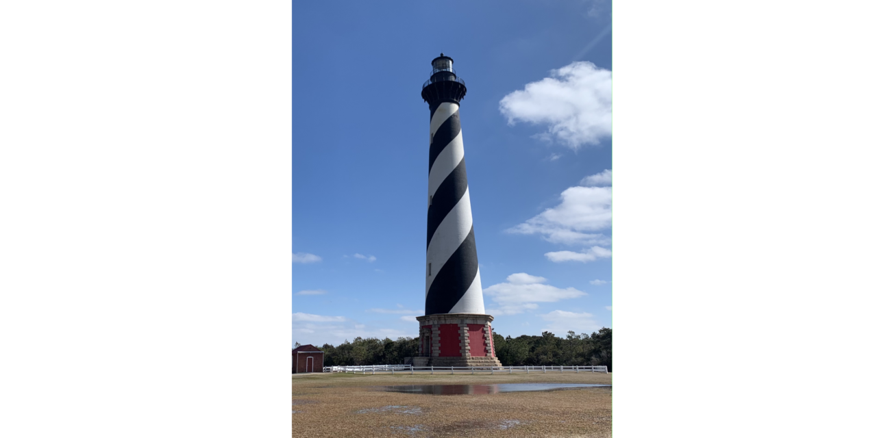
Click here for $19.2M Hatteras Lighthouse restoration gets underway
CoastalReview.org by Catherine KozakBe the first to comment!
LNM: AICW MM 46 ICW Light 116 Damaged, Coinjock Bay, NC

GREAT BRIDGE TO ALBEMARLE SOUND LIGHT 116 (LLNR 37615 [36°23.8837N / 075°57.2339W, 36.398061 / -75.953899]) DAMAGED AND MISSING BOTH DAYBOARDS.
Be the first to comment!
LNM: AICW MM 246, Live Fire Drills, New River Restricted Areas, NC

Click here for SCHEDULED/CAMP LEJUNE MILOPS 12-18 FEB 24/HAZ OPS/SEC NC BNM 0072-24
Click here for SCHEDULED/CAMP LEJUNE MILOPS 05-11 FEB 24/HAZ OPS/SEC NC BNM 0073-24
Be the first to comment!
LNM: AICW MM 246, Live Fire Drills, New River Restricted Areas, NC
Click here for SAFETY/CAMP LEJUNE OPERATING AREAS/HAZ OPS/SEC NC BNM 0061-24
Be the first to comment!
LNM: Alt ICW MM 7, Long Term Deep Creek Bridge Replacement, Dismal Swamp Canal, NC
Our thanks to Sarah Hill, Director of Dismal Swamp Welcome Center, for this notice.

Click here for NTNI – Deep Creek Bridge Replacement Project
Be the first to comment!
LNM: Summary of ATON Markings on Atlantic Windfarms
NC – VA – MD – DE – NJ – ATLANTIC OCEAN – OFFSHORE STRUCTURE PATON MARKING GUIDANCE
For Private Aids to Navigation (AtoN) applicants requesting Coast Guard permits to provide navigational markings on offshore wind farm structures in Fifth District-area waters, the following structure identification, lighting, sound signal, and Automated Identification System (AIS) capabilities are strongly recommended. Applicants should plan to apply for one Private Aid Permit per structure (to include all label(s), light(s), sound signals and AIS signals). Private AtoN Permit applications should be submitted no sooner than 60 days and no later than 365 days prior to
the need to activate a structure’s final markings. Additional specific recommendations include:
Tower/Electrical Service Platform (ESP) Identification:
• Uniquely lettered and numbered in an organized pattern as near to rows and columns as possible
• (Tower) Letters and numbers, visible at night, labelled to as near to 3 meters high as possible, rendered through use of retro-reflective or high contrast black, comparable to MilSpec #17038 or RAL 9005, to maximize visual range for nearby mariners, is strongly recommended • (ESP) Letters and numbers labelled to 1 meter high to visual range for nearby mariners.
• Visible above any servicing platforms
• Visible throughout a 360-degree arc from the water’s surface
• If feasible, also labelled below the servicing platform• (Tower) All-around band, retro-reflective material (white, yellow or silver) is strongly recommended, visible through a 360 degree arc, at least 2 foot bands around the structure no less than 30 ft above MHHW.
• (Tower) Foundation base of all turbines should be painted yellow, comparable to MilSpec #23655 or RAL 1023, all around from Mean Higher High Water (MHHW) to 50 ft above MHHW
Lighting:
• Located on all structures, preferably on the servicing platform, visible throughout a 360-degree
arc from the water’s surface
• Corner Towers/Significant Peripheral Structures (SPSs): Quick flashing yellow (QY) energized at a five nautical mile range
• Outer Boundary Towers: Yellow 2.5 sec (FL Y 2.5s) energized at three nautical mile range
• Interior Towers: Yellow 6 sec or yellow 10 sec (FL Y 6/FL Y 10) energized at a two nautical mile range
• All lights should be synchronized by their structure location within the field of structures
Note: All temporary base, tower and construction components preceding the final structure completion must be marked with Quick Yellow (QY) obstruction lights visible throughout 360 degrees at a distance of 5NM. The QY flashing lights are outlined within the lighting plan during the PATON Permit process.
Sound Signals:
• Should be located on all structures located at corners/SPSs
• Sound every 30 seconds (4s Blast, 26s off)
• Set to project at a range of 2NM
• Should not exceed 3NM spacing between perimeter structures
• Must be Mariner Radio Activated Sound Signal (MRASS) activated by keying VHF Radio frequency
83A five times within ten seconds
• Timed to energize for 45 minutes from last VHF activationAutomated Information System (AIS) Transponder Signals:
• Each Significant Peripheral Structure, and Intermediate Peripheral Structure adjacent to a fairway or used to identify a designated vessel transit route through the farm or closely adjacent farms, shall be identified by a properly encoded AIS message 21.
• The structures may be marked with either physical or synthetic AIS message 21 as circumstances warrant; the broadcasts should be made at sufficient power to provide a relatively uniform coverage recommended to extend at least 8 nautical miles beyond the periphery of the wind farm to allow sufficient time for ship operators to detect and make any necessary course or speed alterations.
• Capable of transmitting signals marking the locations of all structures within the facility.
• Must be approved at the Coast Guard Headquarters level (CG-NAV) based on the Fifth Coast Guard District’s recommendation.
PATON Application can be requested through email to: D05-SMB-CGD5Waterways@uscg.mil
Please forward questions or feedback in an e-mail Matthew.K.Creelman2@uscg.mil or Ryan.P.Doody2@uscg.milBe the first to comment!
REMINDER: LNM: near AICW MM 321, USCG All ATONs Removed Due to Severe Shoaling, Lockwoods Folly Inlet, NC
So far, the shoaling has not affected the ICW/Inlet intersection, a Cruisers Net Problem Stretch. Keep your spars crossed.Update 5/11 Due to significant shoaling in Lockwood’s Folly Inlet of less than 2ft MLW across the entire channel, all buoys were removed at the end of March and early April. There is currently no safe path for navigation. Numerous charted shipwrecks exist in the Inlet that pose additional hazards to navigation at low and high tide.1. THE FOLLOWING AIDS TO NAVIGATION HAVE BEEN DISCONTINUED TO DUE TO SEVER SHOALING IN INLET REDUCING DEPTHS TO TWO FEET MEAN LOW WATER.
A. LOCKWOOD FOLLY INLET LIGHTED BUOY 2 (LLNR 31015 [33°54.4776N / 078°14.3764W, 33.907960 / -78.239606]) – TEMPORALLY DISCONTINUED.
B. LOCKWOOD FOLLY INLET BUOY 3 (LLNR 31020 [33°54.6221N / 078°14.3734W, 33.910369 / -78.239556]) – TEMPORALLY DISCONTINUED.
C. LOCKWOOD FOLLY INLET BUOY 4 (LLNR 31025 [33°54.7466N / 078°14.3558W, 33.912443 / -78.239264]) – TEMPORALLY DISCONTINUED.
D. LOCKWOOD FOLLY INLET BUOY 5 (LLNR 31027 [33°54.8607N / 078°14.3301W, 33.914345 / -78.238835]) – TEMPORALLY DISCONTINUED.
E. LOCKWOOD FOLLY INLET BUOY 6 (LLNR 31030 [33°54.9723N / 078°14.2527W, 33.916205 / -78.237545]) – TEMPORALLY DISCONTINUED.
F. LOCKWOOD FOLLY INLET BUOY 7 (LLNR 31035 [33°55.1134N / 078°14.2651W, 33.918556 / -78.237752]) – TEMPORALLY DISCONTINUED.
G. LOCKWOOD FOLLY INLET BUOY 8 (LLNR 31040 [33°55.1326N / 078°14.2396W, 33.918877 / -78.237327]) – TEMPORALLY DISCONTINUED.
 Click Here To Open A Chart View Window, Zoomed To This AICW Problem Stretch
Be the first to comment!
LNM: AICW MM 246, Live-Fire Drills, New River Restricted Areas, NC
1. THE RESTRICTED AREAS IN THE NEW RIVER
Click here for SAFETY/NC – NEW RIVER – FIRING EXERCISES FROM 01 MAY 2023 TO 07 MAY 2023/HAZ OPS/SEC NC BNM 0176-23
Be the first to comment!
LNM: Pamlico Sound, Lighted Buoy 13A Damaged, Hatteras Inlet, NC
HATTERAS INLET CHANNEL LIGHTED BUOY 13A (LLNR 28735.3 [35°12.2796N / 075°43.8516W, 35.204660 / -75.730860]) AID REPORTED DAMAGED AND EXTINGUISHEDBe the first to comment!
LNM: AICW MM 224 ICW Light 41 Destroyed, Bogue Sound, NC
BOGUE SOUND LIGHT 41 (LLNR 39025 [34°40.5818N / 077°2.2200W, 34.676364 / -77.037000]) RPTD DESTROYEDBe the first to comment!
LNM: AICW MM 246, Live-Fire Drills, Mar 13-19, New River Restricted Areas, NC
Click here for SAFETY/CAMP LEJUNE OPERATIONS 13-19 MAR 23/ATON/
Be the first to comment!
LNM: AICW MM 246, Live-Fire Drills, New River Restricted Areas, NC
Click here for details SAFETY/NC – NEW RIVER – FIRING EXERCISES FROM 27 FEB 2023 TO 05 MAR 2023/MARINE EVENT/SEC NC BNM 0063-23
Be the first to comment!
LNM: Pamlico Sound, Lighted Buoy 12A Off-Station, Hatteras, NC
This inshore lighted buoy helps mark the channel to Hatteras Village.
HATTERAS INLET CHANNEL LIGHTED BUOY 12A, (LLNR 28732.1 [35°12.3290N / 075°43.8856W, 35.205484 / -75.731426]), REPORTED OFF STATION.
Be the first to comment!
LNM: AICW MM 246, Live Fire Drills, New River Restricted Areas, NC
Click here for SCHEDULED/CAMP LEJUNE MILOPS08-14 JAN 24/HAZ OPS/SEC NC BNM 0003-24
Be the first to comment!
LNM: AICW MM 246, Live-Fire Drills, New River Restricted Areas, NC
Click link below for restrictions:
SAFETY/NC – NEW RIVER – FIRING EXERCISES FROM 15 AUG TO 21 AUG 2022/MARINE EVENT/SEC NC BNM 0299-22
Be the first to comment!
LNM: BOLO Missing Boater, South River, NC
South River extends southward of the Neuse River east of Adams Creek.
News Release U.S. Coast Guard 5th District Mid-Atlantic
Contact: 5th District Public Affairs
Office: (757) 398-6272
After Hours: (757) 295-8435
5th District online newsroomCoast Guard searches for missing boater in Pamlico Sound, North Carolina
WILMINGTON, N.C. — The Coast Guard is searching Pamlico Sound for a missing boater Wednesday after he did not return to shore as expected Tuesday evening.
The missing boater has been identified as 38-year-old John Hess, from Buxton.
Watchstanders at the Coast Guard Sector North Carolina command center received notification of the situation from Carteret County Emergency Dispatch at 10:15 a.m. Wednesday.
It was relayed that Hess took a friend’s 23-foot boat from a private residence in Beaufort onto the South River at about 4:30 p.m Tuesday and did not return at night as expected.
The boat’s owner searched for Hess overnight with no results, then alerted authorities.
A Coast Guard Air Station Elizabeth City MH-60 Jayhawk Helicopter crew and response boat crews from Coast Guard Station Hatteras Inlet and Coast Guard Station Hobucken are searching for Hess.
Also assisting in the search are personnel from the North Carolina Wildlife Resources Commission, Harkers Island Fire Department, North Carolina Marine Patrol, and the South River-Merrimon Fire Department.
Anyone with additional information regarding this case should contact the Sector North Carolina command center at 910-343-3880.
-USCG-
Be the first to comment!
LNM: near AICW MM 294 Inlets ATONs Relocated, Carolina Beach Inlet, NC
1. THE FOLLOWING AIDS TO NAVIGATION HAVE BEEN RELOCATED TO MARK BEST WATER.
A. CAROLINA BEACH INLET BUOY 1 (LLNR 30265 [34°4.8332N / 077°51.7038W, 34.080553 / -77.861730]) RELOCATED DUE TO APPROXIMATE POSITION 34-04-52.681N 077-51-43.064W (34°4.8780N / 077°51.7177W, 34.081300 / -77.861962) .
B. CAROLINA BEACH INLET BUOY 2 (LLNR 30270 [34°4.9112N / 077°51.7151W, 34.081854 / -77.861919]) RELOCATED DUE TO APPROXIMATE POSITION 34-04-54.164N 077-51-43.252W (34°4.9027N / 077°51.7208W, 34.081712 / -77.862014) .
C. CAROLINA BEACH INLET BUOY 3 (LLNR 30275 [34°4.9340N / 077°52.0313W, 34.082233 / -77.867189]) RELOCATED DUE TO APPROXIMATE POSITION 34-04-55.265N 077-51-59.067W (34°4.9211N / 077°51.9844W, 34.082018 / -77.866407) .
D. CAROLINA BEACH INLET BUOY 5 (LLNR 30285 [34°4.9558N / 077°52.4033W, 34.082597 / -77.873389]) RELOCATED DUE TO APPROXIMATE POSITION 34-04-57.617N 077-52-26.132W (34°4.9603N / 077°52.4356W, 34.082671 / -77.873926) .
E. CAROLINA BEACH INLET BUOY 6 (LLNR 30290 [34°4.9769N / 077°52.1887W, 34.082949 / -77.869812]) RELOCATED DUE TO APPROXIMATE POSITION 34-04-58.402N 077-52-29.135W (34°4.9733N / 077°52.4856W, 34.082889 / -77.874760) .
F. CAROLINA BEACH INLET BUOY 7 (LLNR 30295 [34°4.9364N / 077°52.5247W, 34.082273 / -77.875412]) RELOCATED DUE TO APPROXIMATE POSITION 34-04-51.816N 077-52-36.454W (34°4.8636N / 077°52.6076W, 34.081060 / -77.876793) .
G. CAROLINA BEACH INLET BUOY 8 (LLNR 30300 [34°4.9768N / 077°52.4621W, 34.082946 / -77.874369]) RELOCATED DUE TO APPROXIMATE POSITION 34-04-46.954N 077-52-46.676W (34°4.7825N / 077°52.7779W, 34.079709 / -77.879632) .Be the first to comment!
LNM: AICW MM 246, Live-Fire Drills, New River Restricted Areas, NC
Click link below for restrictions:
SAFETY/NC – NEW RIVER – FIRING EXERCISES FROM 01 AUG TO 07 AUG 2022/MARINE EVENT/SEC NC BNM 0283-22
Be the first to comment!
LNM: MSIB: AICW MM 246 Military Operations, New River Restricted Areas, NC
Live-fire drills in the New River restricted areas, inshore and offshore, are associated with Marine Base Camp Lejeune and, as indicated in the notice below, these areas are closed to navigation and restrictions will continue for some time. Closures of the ICW may occur in the area.
SAFETY/MILITARY OPERATIONS/HAZARD/SEC NC BNM 0175-22
Be the first to comment!


Social Media Auto Publish Powered By : XYZScripts.com
Be the first to comment!