Barney Slough is the northernmost of two channels connecting Hatteras with Pamlico Sound. This shoaling appears to be on the southwest side of the channel.
Old Topsail Creek connects New Topsail Inlet with the Waterway at Mile 270. Buoys 1 and 2 are inshore, on the northeast side of the inlet. LLNRs given below are incorrect.
THE SHOAL ADJACENT TO OLD TOPSAIL CREEK BUOYS 1(LLNR 30032 [34°20.7287N / 077°39.9956W, 34.345478 / -77.666594]) AND 2 (LLNR 30033) HAS STARTED TO CLOSE OFF THE ENTERANCE TO THE CREEK. DEPTHS BETWEEN THE AIDS WAS OBSERVED TO 5 FT AND BELOW ACROSS THE ENTIRE CHANNEL. ALL MARINERS ARE ADVISED TO TRANSIT WITH EXTREME CAUTION.
These live-fire drills in the New River restricted areas, inshore and offshore, are associated with Marine Base Camp Lejeune and, as indicated in the notice below, these areas are closed to navigation and restrictions will continue for some time.
These orange 9.5 ft tall, 23ft unmanned surface vessels will have a white, all-round light and radar reflector. Speed is 1.5kts. NOAA is requesting greater than 500 meters stand-off.
NC – SC – GA – FL – SEACOAST – UNMANNED SURFACE RESEARCH VEHICLE
Saildrone, Inc. will be operating uncrewed Surface Vehicles called Saildrones for the purpose of oceanographic and fisheries data collection. Two Saildrones will operate from Jacksonville, FL on July 23rd. Of the two Saildrones deployed from Jacksonville, FL, one will operate in inshore and offshore waters off the coast of North Carolina throughout the summer to approximately November 15, 2021. Chart 11520 LNM 28/21
Share:
Comments from Cruisers (1)
Glenn Holland- July 19, 2021 - 8:21 am
Glad to hear this news. I won't even consider picking a race although it would be tempting @ 1.5 kts. Catboat driver
These live-fire drills in the New River restricted areas, inshore and offshore, have been ongoing since 2019 and, as indicated in the notice below, these areas are closed to navigation and restrictions will continue for some time.
These ICW buoys are on the southeast shoulder of the Waterway south of its intersection with Howards Creek.
THE FOLLOWING AIDS TO NAVIGATION HAVE BEEN RELOCATED TO MARK BEST WATER.
NEW RIVER – CAPE FEAR RIVER BUOY 99 (LLNR 39547 [34°21.5792N / 077°40.3919W, 34.359653 / -77.673199]) HAS BEEN RELOCATED TO POSITION 34-21-34.718N, 077-40-23.369W (34°21.5786N / 077°40.3895W, 34.359644 / -77.673158) .
NEW RIVER – CAPE FEAR RIVER BUOY 99A (LLNR 39548 [34°21.2979N / 077°40.8884W, 34.354965 / -77.681474]) HAS BEEN RELOCATED TO POSITION 34-21-15.729N, 077-40-54.988W (34°21.2621N / 077°40.9165W, 34.354369 / -77.681941) .
NEW RIVER – CAPE FEAR RIVER BUOY 121 (LLNR 39597 [34°15.0071N / 077°46.9064W, 34.250118 / -77.781774]) HAS BEEN RELOCATED TO POSITION 34-14-58.624N, 077-46-56.130W (34°14.9771N / 077°46.9355W, 34.249618 / -77.782258) .
NEW RIVER – CAPE FEAR RIVER BUOY 121A (LLNR 39598 [34°14.9245N / 077°46.9776W, 34.248742 / -77.782960]) HAS BEEN RELOCATED TO POSITION 34-14-56.380N, 077-46.58(34°14.9396N / 077°46.5800W, 34.248994 / -77.776333) -057W.
After numerous complications with dredging the South Ferry Channel, the Army Corps of Engineers reported to the Dare County Waterways Commission at its Monday meeting that the hopper dredge Murden has finally started work removing the problem shoal.
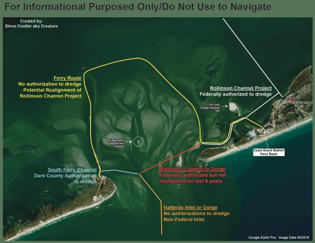
The federal authorization status of various areas in Hatteras Inlet, as compiled by Waterways Commission Chair Steve “Creature” Coulter.
Mariners may visit the NAVCEN website and subscribe for email delivery of BNMs.
NJ – PA – DE – MD – DC – VA – NC – US COAST GUARD 5TH DISTRICT BROADCAST NOTICE TO MARINERS
The U.S. Coast Guard Navigation Center (NAVCEN) has completed its Maritime Safety Information (MSI) project upgrade to offer Broadcast Notice to Mariners (BNM) to mariners via email in addition to voice radio broadcasts. The online subscription service is in addition to the standard BNM broadcasts over VHF radio that previously, were the only way to receive this vital navigational information. Mariners can now use the subscription service to plan for underway periods and receive updates to Aids to Navigation and navigational hazards in near real time without having to wait on scheduled VHF broadcasts. Mariners may visit the NAVCEN website and subscribe for email delivery of BNMs. https://www.navcen.uscg.gov/?pageName=feeds. BNMs are organized by Coast Guard Sector and mariners can subscribe to one, or more Fifth District Sectors. It is also recommended that you subscribe to the “5th Coast Guard District (dpw)” BNMs and the “Atlantic Hazardous Weather Outlook”. Additionally, NAVCEN has developed an online, filterable, BNM archive that is available to the public. 5th District BNMs can be viewed and downloaded from this database on the NAVCEN website at: https://www.navcen.uscg.gov/bnmmessages/DistrictSearchV1.php?d=5&i=4html. For any questions regarding these services contact the NIS Watch at 703-313-5900. LNM 13/21
NOAA HAS ANNOUNCED A DYNAMIC MANAGEMENT AREA ESTABLISHED FOR AN AGGREGATION OF NORTH ATLANTIC RIGHT WHALES SIGHTED NEAR OUTER BANKS, NORTH CAROLINA
MARINERS ARE REQUESTED TO ROUTE AROUND OR TRANSIT AT 10 KNOTS OR LESS THROUGH THE FOLLOWING AREA.
OUTER BANKS, NC AREA ACTIVE THROUGH 20 JAN 2021. NORTHERN BOUNDARY 35-38N, SOUTHERN BOUNDARY 34-57N, EASTERN BOUNDARY 074-48W, WESTERN BOUNDARY 75-35W. 2.
As the first inlet into NC waters south of the Chesapeake, Oregon Inlet is very tempting to offshore cruisers. HOWEVER, Oregon Inlet is notorious for shoaling, keeping the USCG busy relocating ATONs. Even with this dredging project, Cruisers Net still recommends attempting navigation ONLY with shoal draft and good local knowledge.
DUE TO SHOALING IN OREGON INLET, MANY OF THE PHYSICAL AIDS TO NAVIGATION ARE NOT MARKING BEST WATER AND ARE PRODUCING A MISLEADING SIGNAL. 2. THE FOLLOWING TEMPORARY AIS SIGNALS HAVE HAS BEEN ESTABLISHED TO MARK BEST WATER. A. OREGON INLET SAFE WATER MARK OI ESTABLISHED IN APPROX POSITION 35- 48-44.225(35°0.0000N / 048°44.2250W, 35.000000 / -48.737083) N, 075-31-49.840W, AIS MMSI # 993672418. B. OREGON INLET PORT HAND MARK 1 ESTABLISHED IN APPROX POSITION 35-48-23.331N 075-31-44.111W (35°48.3889N / 075°31.7352W, 35.806481 / -75.528920), AIS MMSI # 993672598. C. OREGON INLET STARBOARD HAND MARK 2 ESTABLISHED IN APPROX POSITION 35-48-23.500N 075-31- (35°48.3917N / 075°31.0000W, 35.806528 / -75.516667) 56.074W, AIS MMSI # 99367298. D. OREGON INLET PORT HAND MARK 3 ESTABLISHED IN APPROX POSITION 35-48-01.428N 075-31-48.155W (35°48.0238N / 075°31.8026W, 35.800397 / -75.530043), AIS MMSI # 993672553. E. OREGON INLET STARBOARD HAND MARK 4 ESTABLISHED IN APPROX POSITION 35-48-02.944N 075-31(35°48.0491N / 075°31.0000W, 35.800818 / -75.516667) ‘-56.411W, AIS MMSI # 993672597. F. OREGON INLET STARBOARD HAND MARK 6A ESTABLISHED IN APPROX POSITION 35-47-41.508N, 075-31-56.268W (35°47.6918N / 075°31.9378W, 35.794863 / -75.532297), AIS MMSI # 993672595. G. OREGON INLET STARBOARD HAND MARK 8 ESTABLISHED IN APPROX POSITION 35-47-21.157N, 075-31-49.228W (35°47.3526N / 075°31.8205W, 35.789210 / -75.530341), AIS MMSI # 993672466. H. OREGON INLET PORT HAND MARK 9 ESTABLISHED IN APPROX POSITION 35-47-22.877N, 075-31-45.000W (35°47.3813N / 075°31.7500W, 35.789688 / -75.529167), AIS MMSI # 993672496.
An important reminder for our North Carolina locals and for off-shore cruisers. Local knowledge is recommended for most for these inlets.
NC – HAZARDS OF NORTH CAROLINA COASTAL INLETS Hazardous inlets. To heighten public awareness about the hazards that exist in and around the North Carolina coast, this information is provided to mariners. Shoaling conditions exist at following North Carolina coastal inlets: Oregon Inlet Hatteras Inlet Ocracoke Inlet Barden Inlet Beaufort Inlet Bogue Inlet New River Inlet Topsail Inlet Masonboro Inlet Carolina Beach Inlet Lockwoods Folly Inlet Shallotte Inlet Shoaling conditions increase the potential for groundings. These inlets are subject to continual and sometimes rapid environmental changes. Mariners are highly encouraged to obtain the most recent U.S. Army Corps of Engineers Wilmington, North Carolina District hydrographic survey information, centerline waypoints and controlling depth at: http://www.saw.usace.army.mil/Missions/Navigation/HydrographicSurveys.aspx Mariners should use caution when navigating in these areas and passage through the inlets is not recommended without local knowledge of the area. The aids to navigation in these inlets may not be charted and may not be marking best water due to continually shifting shoals. Consult Local Notice to Mariners, 5th Coast Guard District for the latest positions and status of aids to navigation: https://www.navcen.uscg.gov/?pageName=lnmDistrict®ion=5 To report any aids to navigation discrepancies (missing, damaged, off station, extinguished lights), shoaling, hazards to navigation, or discrepancies on bridge lighting, please contact Sector North Carolina Command Center (910) 343-2200.
All of these relocated buoys are in the shallow waters near Hatteras Inlet.
CCGD5 BNM 492-20 NC CAPE HATTERAS – HATTERAS INLET (CHART 11555) 1. THE FOLLOWING AID TO NAVIGATION HAS BEEN RELOCATED. A. BARNEY SLOUGH CHANNEL BUOY 3A (LLNR 28721.6 [35°13.4891N / 075°47.2234W, 35.224819 / -75.787057]) HAS BEEN RELOCATED TO APPROX. POSITION 35-13.391N 075-47-14.176W (35°13.3910N / 075°47.2363W, 35.223183 / -75.787271)
CCGD5 BNM 493-20 NC CAPE HATTERAS – HATTERAS INLET (CHART 11555) 1. THE FOLLOWING AID TO NAVIGATION HAS BEEN RELOCATED. A. HATTERAS INLET BUOY 12B (LLNR 28733.1 [35°12.2021N / 075°43.9067W, 35.203369 / -75.731778]) HAS BEEN RELOCATED TO APPROX. POSITION 35-12-11.824N, 075-43-55.492W (35°12.1970N / 075°43.9249W, 35.203284 / -75.732081)
CCGD5 BNM 491-20 NC CAPE HATTERAS – HATTERAS INLET (CHART 11555) 1. THE FOLLOWING AID TO NAVIGATION HAS BEEN RELOCATED. A. HATTERAS INLET CHANNEL LIGHT 19A (LLNR 28765 [35°12.2594N / 075°43.2737W, 35.204323 / -75.721228].1) HAS BEEN RELOCATED TO APPROX. POSITION 35-12-22.182N, 075-43-15.216W (35°12.3697N / 075°43.2536W, 35.206162 / -75.720893) . B. HATTERAS INLET CHANNEL LIGHTED BUOY 12A (LLNR 28732 [35°12.6338N / 075°43.9497W, 35.210563 / -75.732495].1) HAS BEEN RELOCATED TO APPROX. POSITION 35-12-19.060N, 075-43-54.971W (35°12.3176N / 075°43.9162W, 35.205294 / -75.731936) . C. HATTERAS INLET CHANNEL LIGHT 19 (LLNR 28765 [35°12.2594N / 075°43.2737W, 35.204323 / -75.721228]) HAS BEEN RELOCATED TO APPROX. POSITION 35-12-14.587N, 075-43-16.377W (35°12.2431N / 075°43.2730W, 35.204052 / -75.721216) . D. HATTERAS INLET CHANNEL LIGHTED BUOY 12 (LLNR 28732 [35°12.6338N / 075°43.9497W, 35.210563 / -75.732495]) HAS BEEN RELOCATED TO APPROX. POSITION 35-12-36.785N, 075-43-55.362W (35°12.6131N / 075°43.9227W, 35.210218 / -75.732045) .
Just south of the Waterway’s 90 degree turn at Mile 135, this river light marks Durant Point off the east side of the Waterway.
PUNGO RIVER LIGHT 8 (LLNR 32915 [35°30.1447N / 076°35.6132W, 35.502412 / -76.593554]) IS DESTROYED, WRECKAGE REMAINS. ALL MARINERS ARE REQUESTED TO TRANSIT THE AREA WITH CAUTION.


Be the first to comment!