117 Horses at Lookout: Report, Cape Lookout, east of NC AICW MM 205
Cape Lookout Bight is a popular anchorage located west of Cape Lookout National Seashore. See Cape Lookout.
117 Horses at Lookout: Report
Coastal Review Online
Cape Lookout Bight is a popular anchorage located west of Cape Lookout National Seashore. See Cape Lookout.
117 Horses at Lookout: Report
Coastal Review Online
The popular Cape Lookout Bight anchorage is practically in the shadow of Cape Lookout Lighthouse. In rough offshore weather, cruisers with shallow draft may choose to access the anchorage via Taylor Creek and Barden Inlet which separates Shackleford Banks and Core Banks. These shallow, sparsely marked waters require a constant eye on the depth finder.

Lookout Closer to Becoming Dark Sky Park
Coastal Review Online
Click Here To Open A Chart View Window, Zoomed To the Location of Cape Lookout Bight
This inlet channel buoy is on the east side of the Cutoff range between Fort Macon and Shackleford Pt.

1. THE FOLLOWING AID TO NAVIGATION HAS BEEN RELOCATED.
A. BEAFORT INLET LIGHTED BUOY 14 (LLNR 29370 [34°41.5102N / 076°40.0486W, 34.691837 / -76.667476]) TO APPROX POSIT 34-41-32.789N,076-40-05.587W (34°41.5465N / 076°40.0931W, 34.692441 / -76.668219) .
Morehead City Yacht Basin, A CRUISERS NET SPONSOR, is located on the southern flank of the marked channel that runs west from Mile 203 of the Waterway, just north of the Morehead-Beaufort high-rise bridge.
Update for Morehead City Yacht Basin
“Morehead City Yacht Basin is open for transients and fueling. Morehead City does not show any signs of limiting boaters ability to re-provision in the city as Beaufort, NC has done. North Carolina is under an Order by the Governor to not limit any movement to essential needs like food, medical, fuel, etc. You may do so in Morehead City as long as it is essential. The restaurant next to the marina, Floyd’s, remains open to take out, as well as several other restaurants in the area. We ask that you stay on your boat except for any essential needs and that you use social distancing throughout the marina. We have a limited staff that will help you dock and fuel. We ask that you give a credit card over the phone as well as an email address for the reservation form and receipts.”
Click Here To Open A Chart View Window, Zoomed To the Location of Morehead City Yacht Basin
Morehead City Yacht Basin, A CRUISERS NET SPONSOR, is located on the southern flank of the marked channel that runs west from Mile 203 of the Waterway, just north of the Morehead-Beaufort high-rise bridge. Our thanks to Bru Brubaker for these king words.
We continue to stop at Morehead City Yacht Basin because of good protection, proximity of restaurants, GREAT dock hands, clean facility, good bathrooms, easy off and back on ICW, and the nice boaters who use this marina. If fueling and/or pumping out, pay attention to the floater in the basin; the depth is shallow outside it. The Ruddy Duck Restaurant has outstanding crispy duck in a serving large enough for lunch seconds the next day.
Bru Brubaker
Click Here To Open A Chart View Window, Zoomed To the Location of Morehead City Yacht Basin
Congratulations to Morehead City Yacht Basin, A CRUISERS NET SPONSOR, for their placement in this annual competition. Morehead City Yacht Basin is located on the southern flank of the marked channel that runs west from Mile 203 of the Waterway, just north of the Morehead-Beaufort high-rise bridge.
Morehead City Yacht Basin has earned Honorable Mention as a top contender in ValvTech’s annual Best Marinas award competition.
“With so many deserving marinas having excellent qualifications, picking a winner is no easy task. Congratulations to Conch Harbor,” said Marvin Griffin, President of ValvTect.
“I would like to mention the other top contenders for this award – Newport Yachting, Noank Shipyard, Haulover Marine Center, Bayport Marina, Camden on the Lake Marina, Point Oasis Marina, Morehead City Yacht Basin, Swanton Marina, Algonac Harbor, Concord Marina and Pier 1000. Congratulations to all,” he added.
ValvTect judges entries based on operations, commitment to customer service and environmental stewardship.
Click Here To Open A Chart View Window, Zoomed To the Location of Morehead City Yacht Basin
Beaufort is a major port of call for Waterway cruisers and the harbor is home to Morehead City Yacht Basin, A CRUISERS NET SPONSOR! Happily, the marina is up and fully functional following Florence. Our thanks to S.A. Scudder for this story link.
Beaufort staff to crack down on derelict boats
Posted: Saturday, September 29, 2018 11:30 pm
BEAUFORT — Town officials are taking the initial steps to rid Beaufort of illegal moors and anchored boats.
CLICK HERE FOR THE FULL REPORT from Carteret County News-Times
Click Here To Open A Chart View Window, Zoomed To the Location of Morehead City Yacht Basin
Bob and Ann Sherer, authors of 2017 ICW Cruising Guide and their popular blog, http://fleetwing.blogspot.com/, generously continue to share their research of Waterway trouble spots with our readers. Having run aground in the often shoaled Russell Creek “shortcut” into Beaufort’s waterfront, this editor can vouch for the area’s confusing array of buoys. Thank you Bob and Ann!
We’ve all faced a passage where the buoy placements don’t match our charts but when it happens at an already confusing area, it’s doubly confusing – especially whens the new buoys don’t seem to make sense. The junction between the ICW and the channel to Beaufort, NC, is such and area. The Coast Guard made major revisions to the buoys in the area and the charts have not caught up with the changes. Not even Navionics which usually does a very good job shows all the buoys in their correct positions. I used the updated light list to show the correct placements compared to what’s on most charts.
First, here’s the area of interest:
Here’s the NOAA ENC chart for the junction:
Now for the surprise, the actual buoy placement after the Coast Guard got done:
What a difference! 28A is gone, RS has been moved northward, and 30A and 30 have been moved. Imagine the confusion in approaching this area from the north when all you have is a NOAA ENC chart which most of the chartplotter manufacturers base their own charts on. For more information on the changes and how charts from different chart providers compare see:
When Charts Lie: Part I
When Charts Lie: Part II
Bob Sherer
aka Bob423
2017 ICW Cruising Guide
This potential new delivery service to boaters is interested in your opinion and in your dietary needs when navigating in NC waters. Please copy/paste the survey into your email compose and mail to livingwelldowneast@centurylink.net. Morehead City and New Bern are homes to SALTY SOUTHEAST CRUISERS’ NET SPONSORS, Morehead City Yacht Basin and New Bern Grand Marina. Many thanks!
Living Well Down East is a Natural and organic market interested in providing delivery service to cruisers who dock/layover in the Beaufort, Morehead City or New Bern, North Carolina areas. We are very interested in your opinion and hope you will take a few minuets to share your thoughts in this brief survey.
1. Do your cruises bring you to North Carolina?
______Yes ______No
2. How often do you cruise in North Carolina?
___Weekly ____Monthly ___ Three times/yr ____More than six times/yr.
3. What time of year are you in North Carolina? Please check all that apply
_____Spring ____Summer _____Fall ____Winter
4. Which location would best serve your provision needs?
_____Beaufort _____Morehead City _____New Bern
5. When taking a cruise do you replenish your provisions?
____Yes ___No
6. If you replenish, how often do you purchase provisions?
____daily ____weekly ____monthly
7. Do you find it difficult to find locations to replenish provisions?
______Yes ______No
8. Would you order provisions in advance of your cruise arrival to your slip?
_____Yes ____No
9. What is your preferred form of food provisions? If mixed please show percent of each
_____Frozen ___Canned ___Fresh ___Freeze Dried ___Glass ___Vacuum sealed ___Other
10. Do you provision bottled water for drinking and cooking while cruising?
_____Yes ____No
11. What size bottled water is ideal for your cruising?
_____1 liter bottles _____1 Gal. bottles _____5Gal. bottles
12. Are beers and/or wines part of your provisions?
Beer ____Yes ____No Wine _____Yes ____No
13. Would you be interested in using a service which delivers to your slip?
_____Yes ___No
14. Would you provision low impact, natural and organic products which are kinder to the environment?
____Yes ___No
We thank you greatly for your time and hope we can be of service to you soon!
Make it a Great Day!

Judy B. Johnson
(252)-522-1100
Check us out on Facebook
Click Here To Open A Chart View Window, Zoomed To the Location of Morehead City Yacht Basin
Click Here To Open A Chart View Window, Zoomed To the Location of New Bern Grand Marina

Our thanks to Contributing Editor, Captain Jim Healy, for shareing his perspective on Beaufort and Morehead City, NC, home to SALTY SOUTHEAST CRUISERS’ NET SPONSOR, Morehead City Yacht Basin, located on the southern flank of the marked channel that runs west from Mile 203 of the Waterway, just north of the Morehead-Beaufort, Newport River high-rise bridge.
Beaufort, NC: This is a seaport town near Morehead City; it’s a very pleasant, laid-back, “chillaxin'” place with a small but well done Maritime Museum, many shoppes and some nice local restaurants. For those who might enjoy a short off-shore (maybe 10 miles) cruise, depart the Beaufort Inlet and head out the the bight at the Cape Lookout National Seashore. [See Claiborne’s article on Cape Lookout.] It a large, well protected anchorage, with access to the beach for campfires and swimming. The bight itself is well protected from winds and ocean sea states, but the trip out and back can be too much for some if the wind offshore is up. Plan accordingly.
Jim Healy
Click Here To Open A Chart View Window, Zoomed To the Location of Morehead City Yacht Basin
Click Here To Open A Chart View Window, Zoomed To the Location of Cape Lookout Bight

Always good to hear words of praise for one of our newest SALTY SOUTHEAST CRUISERS’ NET SPONSORS! Homer Smith’s Docks and Marina are located on Town Creek in beautiful Beaufort, NC.
Went into Homer Smith last week and it is a gem and is going to be a top notch marina (actually already is). Fairly easy walk to town great folks and much easier to dock than downtown docks. Also the price is much better, facilities are much better, and the attitude and service of the owners and staff far exceeds the downtown docks. This is now the place to stay if you want to see Beaufort. He has plans for expansion and even more services down the road. Navigating from the north is a piece a cake as you do not have to go under the lift bridge (which is being replaced). Leaving to founder the bridge is same as before. North bound boats can either go under the bridge, or take the Gallants Cut (even though longer, it is easier). Extremely nice docks.
John Winter
Click Here To Open A Chart View Window, Zoomed To the Location of Homer Smith’s Docks and Marina
Taylor Creek runs along Beaufort’s waterfront and the “jig” David Mentions is at the creek’s east end. The Creek connects several narrow cuts through Back Sound that are often used by shallow draft vessels to reach the anchorage behind Lookout Bight.
My question is, has anyone traveled from Beaufort, NC down Taylor’s Creek toward Harkers Island recently? Is the little jig at the end of Taylor’s Creek passable to vessels drawing 3-1/2 feet, and is it reasonably accurately portrayed on the latest charts? Also, is the channel past Harkers Island and through Barden Inlet to Cape Lookout similarly passable and well charted?
Thanks.
David Swanson
s/v Lucky Penny
Has anyone transited the east end of Taylor Creek heading up behind Harker’s to the Cape Lookout Bight recently? I’ve done it several times before in a 16′ skiff without any problems, but it’s been a couple of years. At that time, there were nothing (that I could see) marking a “channel” at the end of the creek. I’ve got a slightly larger skiff now (18′), and will probably be passing thru about 2 hrs. after low tide – just wondering if anyone has had recent experience with that route. Thanks – Don
David, The cut on the east end of Taylors Creek has more markers than this chart is showing. At mid to full tide you can get through here, however the run to the Hook inside has much shallow water and would require local knowledge to run in a vessel drawing 3.5 feet. It would be much safer to run out Beaufort Inlet and down the front side of Shackleford Banks to the Hook of Cape Lookout. Just stay a half mile off the beach.
A SALTY SOUTHEAST CRUISERS’ NET SPONSOR, Morehead City Yacht Basin, located on the southern flank of the marked channel that runs west from Mile 203 of the Waterway, just north of the Morehead-Beaufort, Newport River high-rise bridge.
The Yacht Basin was originally built in 1946. It started out as a pier and a building with an office, lounge with lockers, and a storage room. Around 1952, Bump Styron bought the Yacht Basin and added two piers. The Yacht Basin has always had close ties to the boating and fishing in Morehead City including the Big Rock Blue Marlin Tournament that started in 1957. Bump himself won the tournament in 1970 aboard the “Reel King”. Legend has it that even Ernest Hemmingway at one time fished for marlin out of the Yacht Basin.
The Morehead City Yacht Basin has always been known for its customer service. James Hester, pictured below, greeted boaters for over fifty years and customers still come in and tell stories about his smiling, friendly service.
Today the Morehead City Yacht Basin provides dockage both to slip owners, renters, and transients traveling up and down the ICW. With Mike Pollard as the head dockmaster for close to ten years the tradition of excellent customer service has continued. We have a very comfortable lounge for our guests and we are a short walk to over twenty great restaurants.

In 2014, Jet Matthews tripled the size of the Morehead City Yacht Basin with modern floating docks, 87 large interior slips, and over 1,250 feet of side tie dockage to accommodate vessels up to 200 ft with 30/50/100 amp power and 2 x 100 amp pedestals.


Click Here To Open A Chart View Window, Zoomed To the Location of Morehead City Yacht Basin
When entering the Morehead City waterfront from the “Turning Basin,” Portside Marina is the first facility that will come abeam to the north.
These folks are very helpful, since we had a weather layover. Rate them highly and will return.
Dusty
Click Here To View the Cruisers’ Net’s North Carolina Marina Directory Listing For Portside Marina
Click Here To Open A Chart View Window, Zoomed To the Location of Portside Marina
With a closed vertical clearance of 13ft, the Gallants Channel – Grayden Paul Bridge is off the Waterway and is frequently used by southbound cruisers to visit the Beaufort waterfront. Town Creek , on the north side of the bridge, is home to one of SSECN’s newest SPONSORS: Home Smith’s Docks and Marina.
Just a reminder for those southbound via Beaufort, NC.
If you are taking the `back way’ into Beaufort, via Gallants channel, the Beaufort City Bridge (US 70 ‘“ at Town Creek) does NOT open at 4:30pm, 5:00pm, 5:30pm or 6:00pm. if you miss the 4:00 opening, it’s best take the Morehead City route around Radio Island.
It only adds 1/2 hr or so if you know in advance you’re going to miss the bridge opening.
Geoff Cooke
Click Here To Open A Chart View Window, Zoomed To the Location of Gallants Channel
Click Here To Open A Chart View Window, Zoomed To the Location of Homer Smith’s Docks and Marina
In the past, the Gallants Channel has often been choked with small boats anchored in the channel and fishing. Going around the south route to Beaufort Docks is a lot easier on the nerves.
Shout out a big Welcome to SALTY SOUTHEAST CRUISERS’ NET’s newest sponsor, Homer Smith’s Docks and Marina on Town Creek in beautiful Beaufort, NC.
Ahoy Cruisers,
Slip into waterfront luxury with Homer Smith Docks and Marina, where you’ll find friendly staff and the comfort of a home away from home. Dock your vessel here in our new, state-of-the-art facilities and unwind and discover the beauty of downtown Beaufort, NC and the rest of the Crystal Coast.
Guests who dock with Homer Smith are just an easy walk or golf cart ride away from the history and action of the third oldest town in North Carolina, Beaufort. Enjoy the beautiful scenery, great dining and the quaint shopping on Front Street.
The Staff at Homer Smith’s Docks and Marina
Click Here To Open A Chart View Window, Zoomed To the Location of Homer Smith’s Docks and Marina
This question is unusual, not because of Skipper Aigeltinger’s concern for Waterway depths, but because of his vessel’s 7ft 3inch draft. Whether that draft is fin keel or full keel, that is a lot of draft with which to confront the shallow spots in North Carolina. He has access to our listing of NC Problem Stretches, but is asking for your input into his decision to attempt the ICW from Norfolk to Beaufort, NC, which, fortunately for him, is north of all the Inlet/ICW intersections further south.
I am considering delivering a 44 ft sailboat from the Chesapeake to Florida. Draft is 7 ft 3 in. Would like to know if anyone knows if it’s possible to get that from Norfolk to Beaufort in the ICW ? Or if anyone could direct me to a source for that info.
Thanks, Ed Aigeltinger
Note this praise for Argus:
The Argus soundings are really helpful. I followed ICW all the way from Norfolk to Beaufort, NC and it looks like the most questionable area is a few miles north of Beaufort. (That area just north of the Alligator River bridge where the channel takes a turn or two around some shoals has always been poorly marked. Have to be careful there but I think there’s plenty of water if you stay channel center.) The shallow area just north of Beaufort is at the south end of the Adams Creek Canal and as I recall that part is narrow and the markers are a little far apart making it a little difficult to stay in the channel. On the chart the Argus readings are shown to be out of the channel. So I wonder if the chart is wrong or if whoever did the Argus run missed the channel, hence the shallow readings there ?? Would appreciate any input from anyone re that. I plan to call Jarrett Bay Boatworks and Beaufort Docks and ask for some local knowledge. Would hate to run 199 miles from Norfolk and get 3-4 miles away only to not be able to get there. However, if the readings are right, the shallowest I see is just over 4 ft and the tidal range is about 3 ft so still might be able to skim through at high tide.
Thanks again for your help-Ed
Thanks to all for the info re the ICW depth from Norfolk to Beaufort, NC.
I also spoke with the dockmaster at Beaufort Docks and he assured me there was plenty of depth at Core Creek if one is careful to stay in the channel. It’s narrow there and the markers are a little far apart. Apparently the Argus boat was a little out of channel hence the readings down to 4 ft. Dockmaster also said he has a friend who comes down each year with 9 ft. He said to be careful to stay as close to center as possible in the Alligator River-Pungo River canal as his friend has hit some pretty hard stuff a little off center.
As you mention fixed bridge height is also a concern. Boat I may deliver is 62 ft to mast top and 65 ft to antenna top. (I brought a cat down once and rang almost every beam on the bridges with the antenna. A little nerve wracking.) So if anyone has or hears any local knowledge re bridge height problems I would certainly appreciate the info. I may try to do what I’ve done a few times in the past. Install a 4-5 ft long piece of 1×4 wood at the mast head going forward and then a vertical piece at the forward end that is about a foot higher than the highest solid part of the mast. One can then creep up to the first beam and if this ‘˜indicator’ goes under all is hopefully well. If not heavy reverse is in order.
Thanks again for the info and please keep me in mind if you hear anything else of importance.
Ed Aigeltinger
November 30:
Larry-
Thanks again for your help with ICW depth issue. I had no idea about the ARGUS ‘program’. Obviously with that kind of data in the laptop one could cruise the ICW from data point to data point. Really amazing stuff !
Thanks again,
Ed Aigeltinger
7’+ along the Coinjock or Virgina Cut route is certainly possible. Keep in mind that most of the route, save for Core Creek, near Beaufort, is not tidal, save for wind-driven tides. For that reason, you need to be certain that your air draft (masthead height) is no more than 63′. Not all “65′” bridges have the listed clearance, and there is no tide to help clearance.
We’ve traveled with a boat drawing close to 7′ 6″ who, last time I saw her, had made it as far south as at least the Waccamaw River. We draw 6′ and, with attention to tides, made it to St. Simons Sound before going outside to Fernandina Beach, where we are at the moment.
This can be done. Take the Virginia Route. Be very careful just north of Allligator River Bridge, and go when it is not low water there. Just south of Core Creek Bridge, in Adams Creek, go at mid-tide or higher and stay carefully in the channel. Then head towards Morehead City harbor and double back to get into Beaufort.
I am of the belief that you should not have much trouble with th 7 03″ draft as far as Beaufort, NC I have travelled that portion of the icw with 8ft 2″ of draft from 2000 thru 2004 with a 456 B. Farther south you would have a lot of problems. I now travel that area with 411 B but only draw 5 ft. Best of luck.
Sea Gate Marina guards the Waterway’s western banks, just north of the Core Creek bridge. This facility has a well sheltered harbor, but we’ve noted some thin depths here in the past.
Update: Not for big boats. Transient dock has only 30 amp @ 6.00 per night. The pedestals have 50 amp receptacles but are not wired. The water faucets are not plumbed, however a very long hose is available to reach most of the transient dock. The self-service pumpout has been down all summer but has now been repaired as of 11/2014. Wifi is available at the transient dock but is a residence system with limited bandwidth that is shared with the small campground. Clean showers. Pleasant TV lounge. Friendly adult staff at present. Marina store winter hours 8am ‘“ 5pm. Good selection of beers. Eight miles to shopping. My 4.5’ draft wasn’t a problem.
Tom Geren
Click Here To View the Cruisers’ Net’s North Carolina Marina Directory Listing For Sea Gate Marina
Click Here To Open A Chart View Window, Zoomed To the Location of Sea Gate Marina
Cape Lookout Bight is a wonderful, natural harbor formed by Cape Lookout’s curve of land. This superb anchorage, one of the most popular in North Carolina, as confirmed by Skipper Merriman, is best accessed via the Beaufort Inlet, rather than through Back Sound.
Labor Day Weekend August 30 ‘“ September 2nd 2014
Wow! Just Wow!
This was our first time to Cape Lookout. This place is fantastic. The water is warm and clear enough to snorkel. About 7 -10 feet of visibility, The water has a green tint to it.
We anchored about 3/4 of the way into the bite. We were in 25 feet of water and just a short dinghy row from the beach.
When we first arrived I was concerned because there must have been close to 100 boats in there. However, we had no problem finding a place to drop the hook. The very next morning most of the boats were gone, By day 3 there were only a handful.
The sunsets and sunrises are super. The light house looks great. Although we didn’t make it up to the top. Good fishing, nice walks on the beach,
Anybody who is sailing the coast and doesn’t stop by here is missing out.
Will & Sheila
s/v Sheila B
Click Here To Open A Chart View Window, Zoomed To the Location of Cape Lookout Bight
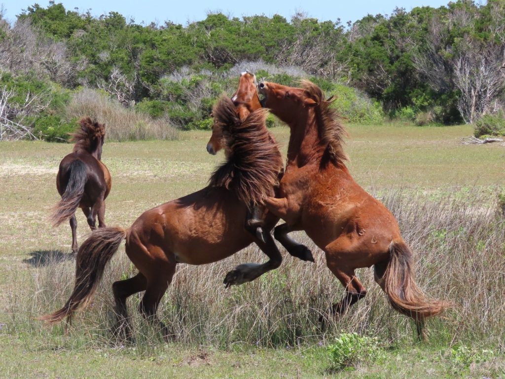
Absolutely one of the most beautiful anchorages! We spent a few days there 2 yrs ago, and were there for 6 nights a few weeks ago. During the week and non-holiday weekends, there are typically only 3-4 boats. Wild horses on the Shackleford Banks shore. Finding numerous and varied seashells is a highlight as well as touring the lighthouse and beachcoming. We had visits from large sea turtles and a river otter. It’s an easy 7 mile trek east of the Beaufort inlet.
Debbie and Howard
S/V Dreamer
It appears Will & Sheila have discovered one of the best kept secrets on the coast. We all hear that Key West is the only spot on the east coast to watch the sun set over the ocean. Not So. Due to the NC coast at Beaufort and Cape Lookout running East-West not North-South, from the bite at Cape Lookout the sun comes up and set over the ocean. A truly beautiful spot.
D. Davis
The current Grayden Paul Bridge over Gallant Channel in Beaufort is a bascule bridge with a closed vertical clearance of 13ft. Adams Creek and Gallant Channel connect southbound Waterway cruisers to the Beaufort waterfront.
The new Grayden Paul Bridge (/?p=143433) will have a fixed vertical clearance of 65ft and a horizontal clearance of 100ft. However, it is obvious from Skipper Cole’s follow-up comments below that the new bridge does indeed impose restrictions on certain vessels. One can understand and sympathize with the frustrations of a marine professional fighting to stay in business.
Having worked in a boat yard for many years, I understand after living in the area 41 years,that Adams creek is not part of the inland waterway. I have read many articles saying it is so. Please get the facts straight. This new bridge is putting our boat restoration business Out of work. Can’t the NCDOT understand that they are putting a lot of people out of work. Many boats have left the area to go to Charleston, Savannah, and Florida. This bridge if built will also impede the shrimp boats.
Judith Cole
August 30, 2014
As Skipper Cole makes clear, the 65ft vertical clearance imposes restrictions on those boat yards who have been servicing vessels in need of greater than 65ft vertical clearance.
Dear Larry , When you compared the new unbuilt bridge 65 ft. Against the present bridge. You failed in your comparison by only stating that it is only 13ft. The Grayden Paul bridge is a draw bridge when it is open the height can not be measured large tall ships with masts a lot higher than 65 feet have been using this bridge before either you or I were born. Please in your next writing quit trying to hide the truth. This new bridge will ruin the tall ships waterway . Adams creek is not part of the waterway,it needs it’s own specific concerns . Tall ships need their own consideration. Does hiding things from the public make it right. No, it is not honest.
Judith Cole
Click Here To Open A Chart View Window, Zoomed To the Location of Gallants Channel
I’d love more of an explanation both about Adam’s Creek and the bridge project! I’ve been traversing Adams Creek for many years and didn’t realize that. On the bridge project, I believe that if we had more detail on how the new bridge will negatively impact business people, we would go to bat for them.


Be the first to comment!