A Forgotten People: Bohemian oyster shuckers on NC coast by David Cecelski


Click here for A Forgotten People: Bohemian oyster shuckers on NC coast
CoastalReview.org
Click here for A Forgotten People: Bohemian oyster shuckers on NC coast
CoastalReview.org

Oriental is home to longtime CRUISERS NET SPONSOR, Oriental Marina and Inn, lying on the eastern banks of inner Oriental Harbor. Our thanks to Bob423 for this information.

Click Here To View the Cruisers Net North Carolina Marina Directory Listing For Oriental Marina
Click Here To Open A Chart View Window, Zoomed To the Location of Oriental Marina

Guests at the Bayview Hotel flock to the sandy bank of the Pamlico River during the establishment’s heyday. Photo courtesy Historic Port of Washington Project Read more at Coastal Review, coastalreview.org.
Click here for Lost riverfront destination, Bayview Hotel nearly forgotten
CoastalReview.org

The Dismal Swamp Route departs the southbound Waterway at MM 7.2 and northbound via the Pasquatank River. Our thanks to Sarah Hill for this invitation from Dismal Swamp Welcome Center, A CRUISERS NET SPONSOR!
Good Morning!
Please save the dates! We’ve got several fall community events planned in Camden County, home of Dismal Swamp State Park, and we hope you will join us to celebrate our local heritage and nature.

*Our Camden Heritage Festival is scheduled for Saturday, September 21st, 2024 from 10am-3pm at Camden Community Park (125 Noblitt Dr., Camden, NC 27921). We are super excited to kick off the day with a performance from the award winning Camden County Bands along with local live entertainment throughout the day. This year’s festivities will include living history re-enactors from the 1st NC Regiment of the Continental Line from Tryon Palace, as we commemorate America 250 NC. We hope you’ll join us for a great community day filled with craft vendors, petting zoo, local business displays, K9 demos, carriage rides, classic cars, food trucks, antique tractors, axe throwing & so much more!

*The Dismal Swamp State Park (2294 US Hwy 17 N, South Mills, NC 27976) will host their 10th Annual Dismal Day event, October 12, highlighting the swamp’s rich natural & cultural history from 10am-2pm. The day kicks off with a 5K Fun Run/Walk along the Dismal Swamp Canal Trail. Don’t miss delicious food, music, wagon rides through the swamp, paddling on the canal, OBX Lizard Land reptiles, craft & activities celebrating the “Year of the Bear”, and educational exhibits.
If you are interested in being a vendor – please let us know. (Camden Heritage Festival Registration ends 8/30/24)
Additional event information coming soon. Please feel free to share, post & print.
Thank you for your continued support and we hope you will be able to join us!
Many thanks,
|
| Sarah Hill, TMP Director, Dismal Swamp Canal Welcome CenterChairperson, Camden County Tourism Development Authority 2356 US Hwy 17 North, South Mills, NC 27976
|

Albemarle Plantation Marina, a port on the Albemarle Loop and a CRUISERS NET SPONSOR, is located just off the AICW on the northern shores of Albemarle Sound on Yeopim River/Creek.
| ||||||
 | ||||||
 | ||||||
 | ||||||
 | ||||||
 | ||||||
 | ||||||
| Discover Albemarle Plantation | Book A Tour | Contact Us | ||||||
 |  | |||||
|
Belhaven Marina sits on the northern shore of Pantego Creek south of the Alligator River – Pungo River Canal and is A CRUISERS NET SPONSOR!

Click Here To View the NC Cruisers Net Marina Directory Listing for Belhaven Marina
Click Here To Open A Chart View Window Zoomed To the Location of Belhaven Marina
Click here for Behind NC coast’s range lights, buoy depots, gas works
CoastalReview.org
Cape Lookout Bight is a wonderful, natural harbor formed by Cape Lookout’s curve of land. This superb anchorage, one of the most popular in North Carolina, The channel between Harkers Island and Cape Lookout Lighthouse has been widened to 100 feet with depths ranging from 7 to 9 feet. This is good news for cruisers wishing to anchor in Cape Lookout Bight southeast of Beaufort.
Click here for Cape Lookout dredging, beach nourishment work complete
Read more at Coastal Review, coastalreview.org.
Click Here To Open A Chart View Window Zoomed To the Location of Cape Lookout Bight
Lat/Lon: 34 37.395 North/076 32.931 West
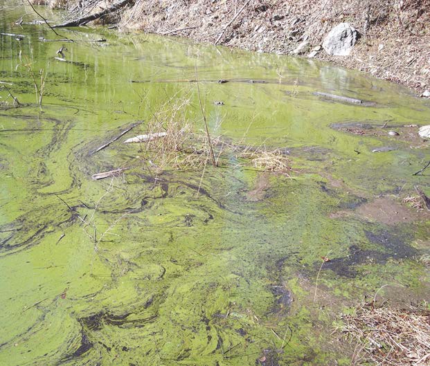
Click here for As temperatures rise, stay away from algal blooms
CoastalReview.org
|
…
[Message clipped] View entire message
 | ReplyForward |
NC – NEW RIVER – CAMP LEJEUNE – NOTICE OF LIVE FIRING AND TRAINING EXERCISES
Marine Corps Installations East-Marine Corps Base Camp Lejeune, North Carolina, Live firing and training:
Mariners traveling in Atlantic Intracoastal Waterway through this area can expect a delays of about one to four hours during the below times. Range Control Boats, from Camp Lejeune, NC monitor Channel 16 VHF-FM and the working Channel 82 VHF-FM. Range Control can be reached at 910-451-3064 or 4449. Camp Lejune MILOPS 06 – 12 MAY 2024.
1. The restricted areas in the Atlantic Ocean east of the New River Inlet as shown on National Ocean Service Chart US5NC14M, will be closed to navigation up to 15 nm seaward because of firing exercises during the following periods:
8:00 A.M. – 5:00 P.M. 08 MAY 24 LIVE FIRE OPERATIONS (24 MEU, NSFS)
8:00 A.M. – 11:59 P.M. 09-10 MAY 24 LIVE FIRE OPERATIONS (10TH MAR-G-7)
Restricted areas in the new river, as shown on National Ocean Service chart US5NC14M, that will be closed to navigation because of stone bay rifle range firing exercises during the following periods:
Stone Creek Sector 12:01 a.m. to midnight daily
Stone Bay Sector 12:01 a.m. to midnight daily
West of the 77 (deg) 26 (min) Longitude line.
The restricted areas that may be closed to navigation because of firing exercises during the following periods:
Traps Bay Sector 12:01 a.m. to midnight daily
Courthouse Bay Sector 12:01 a.m. to midnight daily
Stone Bay Sector 12:01 a.m. to midnight daily
East of the 77 (deg) 26 (min) longitude line.
Grey Point sector 12:01 a.m. to midnight daily
Farnell Bay sector sunrise to sunset daily
Morgans Bay sector sunrise to sunset daily
Jacksonville sector sunrise to sunset daily
2. The target bombing area N1/BT-3 impact area in the Atlantic Ocean east of the new river inlet as shown on national ocean service chart US5NC14M, may be closed to navigation because of firing exercises during the following periods:
8:00 A.M. – 5:00 P.M. 08 MAY 24 LIVE FIRE OPERATIONS (24 MEU, NSFS)
8:00 A.M. – 11:59 P.M. 09-10 MAY 24 LIVE FIRE OPERATIONS (10TH MAR-G-7)
3. Atlantic Intracoastal Waterway, inland waters in the Browns Island Inlet area between Bear Creek and Onslow Beach, may be closed for firing exrcises during the following periods:
8:00 A.M. – 5:00 P.M. 08 MAY 24 LIVE FIRE OPERATIONS
(24 MEU, NSFS)
8:00 A.M. – 11:59 P.M. 09-10 MAY 24 LIVE FIRE OPERATIONS
(10TH MAR-G-7)
4. Due to unexploded ordnance on Browns Island and in the adjacent waterways and marsh areas, Browns Island is off limits to all unauthorized personnel. Vessels may transit the surrounding waters, however no vessel shall bottom fish or anchor.
5. Mariners traveling on the western side of the new river between Stone bay and Farnell Bay should be aware that there are numerous sign poles without working lights and are leaning or submerged as a result of Hurricane Florence and present hazards to navigation. These poles once had signs denoting areas of caution around the Stone bay rifle range and Verona Loop firing ranges.
5A. Signs are located along the stone bay, grey point and Farnell Bay sectors of the New River. Marine Corps Base Camp Lejeune is working to replace these signs.
6. Range control boats, MCIE-MCB CAMLEJ North Carolina monitor channel 16 VHF-FM (156.8 mhz) and the working channel 82 vhf-fm(161.725 mhz). Range Control can be reached by phone at 910-451-3064 or 4449.
With a closed vertical clearance of 14ft, the 2.8-mile bridge across the Alligator River has had lengthy closures to undergo repairs several times in recent years and, with a closure mandate in winds over 25 knots, Alligator River Bridge was almost always an “event” on ICW cruises, events that lead many southbound cruisers to be quests of Elizabeth City Mariners Wharf and guests of the Rose Buddies. See “The Legend of the Rose Buddies” Monument.

The Lindsay C. Warren Bridge over the Alligator River swings open for a pleasure craft. Photo: NCDOT
Click here for Firm to start driving test piles for new Alligator River bridge
CoasalReview.org
See also Federal grant to accelerate Alligator River bridge project, AICW MM 84
Click Here To Open A Chart View Window Zoomed To the Location of Alligator River Bridge
 OLD HOUSE CHANNEL DAYBEACON 10 (LLNR 28270 [35°44.1890N / 075°36.7301W, 35.736484 / -75.612168]) IS MISSING. |
|
…
[Message clipped] View entire message
| ReplyForward |
The Dismal Swamp Route departs the southbound Waterway at MM 7.2. Our thanks to Sarah Hill for this good news from Dismal Swamp Welcome Center, A CRUISERS NET SPONSOR! See original LNM: NAV ALERT
Good Monday Morning,
Per the Norfolk District, U.S. Army Corps of Engineers the historic Dismal Swamp Canal has reopened to boating traffic and resumed normal operations today, April 8th, 2024!
Lock Schedule : 8:30 & 11am and 1:30 & 3:30pm
We hope to see you soon & don’t forget to stop by and grab the new 2024 #DismalSwamp Boating sticker!
Many thanks,
Sarah
Albemarle Plantation Marina, a port on the Albemarle Loop and a CRUISERS NET SPONSOR, is located just off the AICW on the northern shores of Albemarle Sound on Yeopim River/Creek.
 | ||
| Your new Inner Banks Dream Home is closer than you think!Gorgeous, new move-in ready homes by Chesapeake Homes (with homesites of nearly an acre) means you won’t have to wait to enjoy Albemarle Plantation’s waterfront lifestyle. Life here is full of pristine, natural beauty, alongside some of the most With all your daily needs just minutes from the gates, and every amenity | ||
 | ||
 | ||
 | ||
 | ||
 | ||
 | ||
 | ||
| Discover Albemarle Plantation | Plan a Visit | Contact Us | ||
 | 128 Lakeside Drive, Hertford, NC 27944 • (800) 523-5958 • (252) 426-4653 The information contained herein is for informational purposes only and may change at any time without notice. AP Realty Company, LLC/Broker | |
Click Here To Open A Chart View Window, Zoomed To the Location of Albemarle Plantation Marina

Click here for SCHEDULED/CAMP LEJUNE MILOPS 01 – 07 APR 24/HAZ OPS/SEC NC BNM 0161-24


Be the first to comment!