Visit Logged
  • Select Region
    • All Regions
    • VA to NC Line
    • North Carolina
    • South Carolina
    • Georgia
    • Eastern Florida
    • Western Florida
    • Florida Keys
    • Okeechobee Waterway
    • Northern Gulf
    • Bahamas
    • New York
    • Ohio
    • Pennsylvania
    • Washington
    • Puerto Rico
    • Minnesota
    • Maryland
    Order by:
    • Charleston County Parks Debuts 5K Trail Race Series, Charleston, SC

      Cooper River Marina

      Charleston County Parks,  A CRUISERS NET SPONSOR, proudly introduces a 5K trail race series held at some of its most treasured parks for trail runners and walkers. 


      Charleston County Parks debuts 5K trail race series
      Explore the Lowcountry’s best trails in 2022

      Sarah Reynolds

      Public Information Coordinator Charleston County Park & Recreation Commission 

      861 Riverland DrCharlestonSC 29412
      Primary: 843-762-8089


      sreynolds@CCPRC.com|CharlestonCountyParks.com

      Be the first to comment!

    • LNM: AICW MM 465 Parade of Boats, Dec 11, Charleston, SC


      You are reminded that spectator boats navigating in the darkness following the parade are at great risk. Please take your time and keep a sharp watch as you leave your anchorage.

      CHARLESTON PARADE OF BOATS

      Charleston Harbor, SC

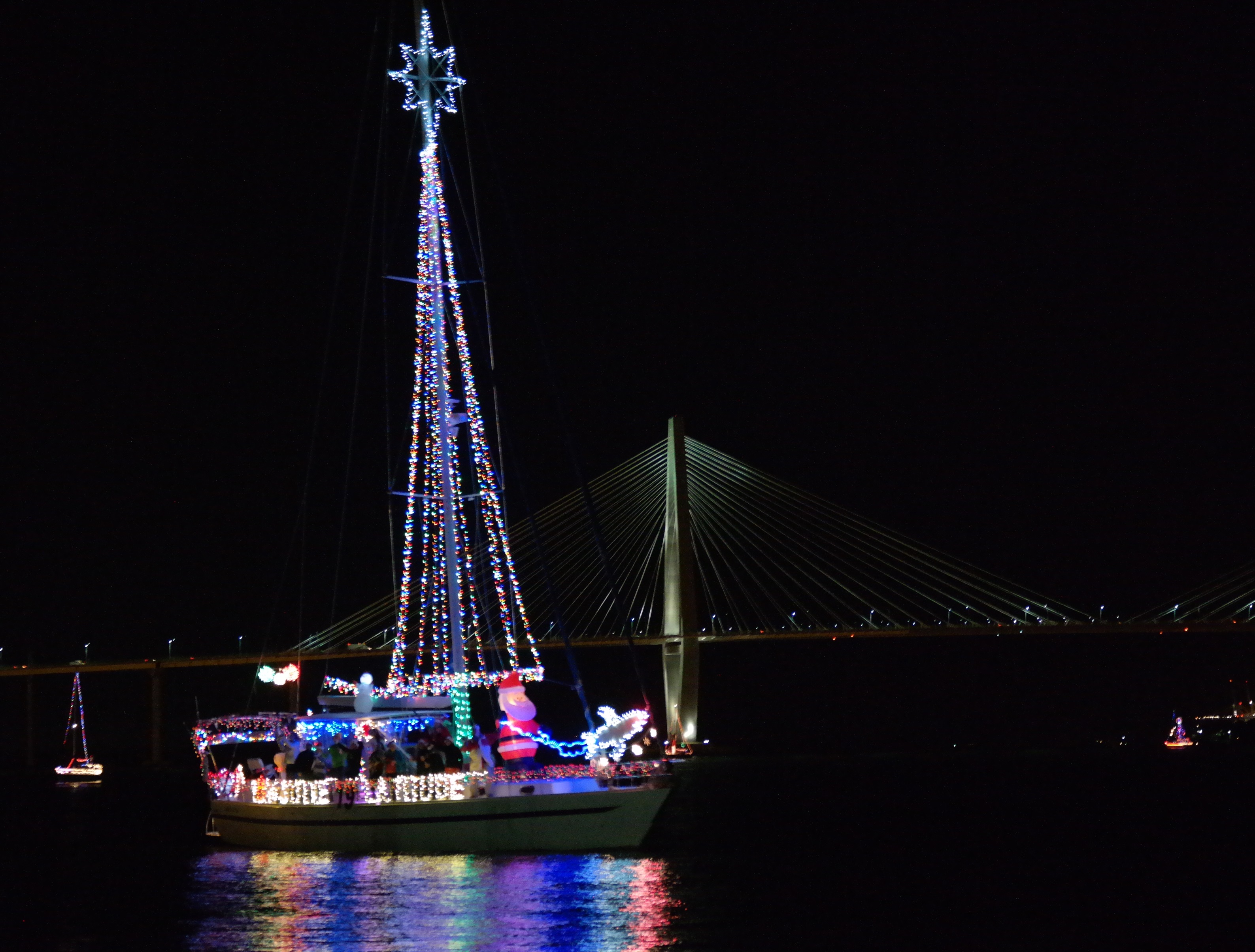
      On Saturday, December 11, 2021 the City of Charleston will host its annual Charleston Parade of Boats in Charleston Harbor from 4 p.m. to 8:30 p.m.

      The parade will assemble in Commercial Anchorage B and begin its northern route around Commercial Anchorage A, continuing up through Bennis Reach, beyond Patriots Point to the Ravenel Bridge. The parade will then transit south down the east side of the Charleston peninsula, and will conclude at City Marina.

      No persons or vessel may enter, transiting through, anchor in, or remain within the designated area unless authorized by the Captain of the Port Charleston or a designated representative.

      This MSIB can be viewed at https://homeport.uscg.mil/port-directory/charleston. For questions or concerns regarding this MSIB, please contact Sector Charleston Waterways Management Division at (843) 740-3184 or the Sector’s 24-hour Command Center at (843) 740-7050.

      AREA SPONSORING MARINAS

      Click Here To View the South Carolina Cruisers Net Marina Directory Listing For Charleston Harbor Marina

      Click Here To Open A Chart View Window, Zoomed To the Location of Charleston Harbor Marina

      Click Here To View the South Carolina Cruisers Net Marina Directory Listing For Cooper River Marina

      Click Here To Open A Chart View Window, Zoomed To the Location of Cooper River Marina

      Be the first to comment!

    • Results from the cleanup! Wounded Nature – Working Veterans

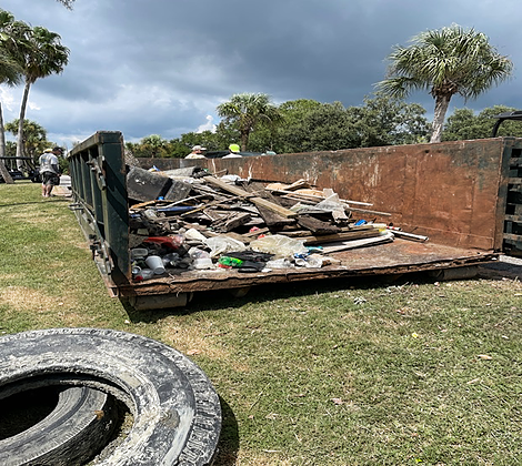
      Wounded Nature-Working Veterans is a group of veterans, non-veterans and active duty military personnel run by Captain Rudy Socha, a former Marine turned conservationist. The non-profit volunteer organization is working to cleanup, preserve and protect our coastal environment, particularly from derelict vessels.


      Results from the cleanup!
      Wounded Nature-Working Veterans

      Be the first to comment!

    • A New Offering from Intracoastal Yacht Sales – Carolina Breeze

      Our focus is to assist boaters with the purchase or sale of their powerboats. All our yacht owners are trained and educated on the handling and systems of their new vessel as part of our service. We want to make sure your experience with us is easy by being thorough with your needs. Through aggressive internet marketing, publication ads, and our long term networks we also have the resources to get your yacht sold! Our experience allows us the understanding of the market place.

      Intracoastal Yacht Sales, a long-time CRUISERS NET SPONSOR, offers full service brokerage representation from three locations: Wrightsville Beach, NC, Little River, SC and Charleston, SC. You will want to see this exceptional cruising vessel! Click link below for full details,


      Carolina Breeze – 2002 44′ CARVER 444 Cockpit Motor Yacht
      Folly Beach South Carolina United States
      $224,900 USD

      Comments from Cruisers (1)

      1. Winston Fowler -  June 17, 2021 - 3:46 pm

        My wife and I purchased this Carver444 in 2002. Took delivery in Wilmington, NC in June. We cruised her until 2012 when family situations caused us to sell her . She has had only two owners in her 19 years… and two owners who cared very much for her. It is our hope that she finds a new owner who will enjoy her and care for her as the past two owners have. She will bring you many happy times and wonderful lifetime memories.
        Her first name was "WinSue" and now she is "Carolina Breeze"….
        Intracoastal Yachts knows this boat well and will be looking for her new owner. Bobby Gregory was involved when we sold her and has her in his care again.

        Reply to Winston
    • Storm Season Guide from Post and Courier, Charleston, SC

      Above-normal tropical activity, new ‘normals’ in the Atlantic and steering robotic surfboards into hurricanes.


      Sponsored by Lowcountry Foundation Repair


      Above-normal tropical activity, new ‘normals’ in the Atlantic and steering robotic surfboards into hurricanes


      Good morning, readers.

      Hurricane Wire is back and ready to bring you details of everything brewing in the Atlantic basin this season.

      Experts believe we could be in for another busy tropical season but nothing quite as bad as what was experienced in 2020. Last year was a record-breaking one with 30 named storms, 13 hurricanes and six major hurricanes. The National Oceanic and Atmospheric Administration does not believe this hurricane season will be as active as the last.

      In a 2021 Atlantic hurricane outlook released last month, NOAA’s acting administrator Ben Friedman said the agency projects a 70% probability of 13 to 20 named storms, six to 10 hurricanes and three to five major hurricanes.

      This may seem like quite a bit of projected tropical activity, but the baseline of “normal” changed in 2021 when meteorologists updated the 30-year period they use to determine average weather benchmarks. Moving forward, an average Atlantic hurricane season will have 14 named storms, seven hurricanes and three major hurricanes.

      So technically, NOAA’s predictions for this season are considered normal. Our Chloe Johnson reports that new weather benchmarks are reflecting a more active Atlantic season. However, scientists still disagree on whether climate change will lead to more hurricanes over the long term. Read more about that here.

      Researchers with the Tropical Meteorology Project at Colorado State University predict there will be 35 days in which a hurricane is active this season, and nine days in which a major hurricane is active. Their forecast for the 2021 hurricane season nearly mirrors the Project’s early prediction for the 2020 season. But last year exceeded expectations in many ways.

      Only time will tell what is in store for the Atlantic this year. So for now, let’s just stay vigilant.


      What’s brewing

      Conditions: Nothing is spinning in the Atlantic, but the National Hurricane Center has issued advisories on tropical depression Blanca located in the eastern Pacific. This is not a concern for South Carolina as the depression is several hundred miles south-southwest of the southern tip of the Baja California peninsula.

      Computer models: The Carolinas are expected to remain clear of threats for the foreseeable future.

      Outlook: Tropical cyclone formation is not expected in the Atlantic basin during the next five days. 

      What we’re talking about

      • Saildrone Inc. and the NOAA is hoping to get new insights into hurricane intensity by steering robotic surfboards into the storms, per Capital Weather Gang.
      • According to Eye on the Storm, the increase in named storms in the Atlantic could be driven by at least five factors, including human-caused global warming.
      • The NOAA predicts the 2021 hurricane season will include above-normal tropical activity, per The Post and Courier. 

      “New normal” for hurricane season keeps rising

      From 1981 to 2010, there were, on average, 12.1 named storms, 6.4 hurricanes and 2.7 major hurricanes of Category 3 or above each year.

      In the new period, 1991 to 2020, there were an average of 14.4 named storms, 7.2 hurricanes and 3.2 major hurricanes each year, according to data analyzed by Brian McNoldy, a senior researcher at the University of Miami.

      Hurricanes in history 

      On May 7, 2015, surf powered by a tropical depression lured a stand-up paddle boarder into the water on Isle of Palms. The storm would become Tropical Storm Ana, with wind gusts reaching 60 mph near Little River and Cherry Grove Beach. (File/Staff)

      Your questions, answered

      Have a question about how hurricanes work, how we cover them or any other storm-related questions? Reply to this email and we may feature your question in an upcoming newsletter!

      Like what we’re doing with Hurricane Wire? Forward this email to a friend!

      If you haven’t signed up for Hurricane Wire, you can sign up for this weekly email here

      Visit our Hurricane Wire Hub for more storm coverage throughout the week. 


      Hurricane Wire is a collaborative project produced by a team of Post and Courier journalists. Shamira McCray is its lead writer. Data visualizations are created by Bryan Brussee. “Hurricane in history” photos are curated by Matthew Fortner. The newsletter is produced and edited by Emily Daily and Matt Clough.


      Recommended for You

      Keep up with the latest climate change and environmental issues impacting the Lowcountry and the rest of South Carolina. In your inbox, every Monday.


      Be the first to comment!

    • SC Oyster Farming Permit Conflicts

      Our thanks to Ted Arisaka for these reports from SC journalists. See Oyster Farming Dispute.


      As you know, in Georgia, the “approved” shellfish harvest areas greatly impinged upon anchorages. Here is an investigative report on alleged conflict of interest in neighboring South Carolina.
      Ted Arisaka

      Shell game: Conflict, secrecy cloud battle over SC oyster farming permit
      Charleston Post Courier

      Uncovered: Conflict, secrecy cloud battle over SC oyster farming permit
      Index-Journal

      Be the first to comment!

    • Wounded Nature Fundraiser – We need YOUR help!

      As much as we might wish to participate, we can’t always put on our gloves and boots and wade into the fray. So here is your opportunity to contribute to the efforts of this fine volunteer group to clean up Charleston’s waterways on our behalf. Please give what you can!


      Wounded Nature – Working Veterans needs your help!  We clean and rehabilitate critical coastal areas that others cannot reach: Trash/Debris, Treated Wood/Tires, Abandoned/Derelict Vessels. 

      We make a Real Coastal Difference but doing this requires the right equipment.  2021 is our year to grow and upgrade our 20+ year old boats with two proper workboats. With the right equipment, we will increase our capacity and reach to do more by going after the really tough to get stuff – big treated wood (dock pilings/telephone poles), buried tires, and all the stuff we’ve been seeing but unable to remove to date.

      Please consider donating.  We have three levels of “perks” so check out the link.  https://igg.me/at/WoundedNature/

      Sharing this fundraiser with your network is just as impactful so please SHARE away to help Wounded Nature – Working Veterans continue to MAKE A REAL COASTAL DIFFERENCE in 2021 and for years to come!

      Thank you all for your support!

      Whit Jones

      Wounded Nature – Working Veterans

      www.woundednature.org

      843-737-1088

      Be the first to comment!

    • USCG: Sector Charleston Prepares for Upcoming Hurricane Season

      See also Hurricane and Severe Weather Preparation.


      SECTOR CHARLESTON

      UPCOMING 2021 ATLANTIC HURRICANE SEASON

      The Atlantic Hurricane Season will begin June 1, 2021 and will run through November 30, 2021. During this timeframe, the assigned port condition (PORTCON) will remain PORTCON IV and the port status will remain OPEN for all ports and waterways within the Sector Charleston Captain of the Port Zone. These waters are identified in 33 CFR 3.35-15 and lie between the intersection of the North Carolina – South Carolina boarder and the northern bank of the Savannah River.

      In the event of forecasted tropical storm force winds (sustained winds of 34 kts/39 mph or greater) from a tropical cyclone, the Sector Charleston Captain of the Port (COTP) will coordinate with the Heavy Weather Advisory Group (HWAG) to evaluate port preparation and changes in port condition.

      The HWAG consists of maritime transportation system professionals local to the Sector Charleston Captain of the Port Zones, providing input on local operations and coordination for overall port well-being in response to severe weather events.

      The COTP will announce changes to port conditions via a Marine Safety Information Bulletin (MSIB) and a Broadcast Notice to Mariners when forecasted tropical storm force winds (sustained winds of 34 kts/39 mph or greater) from a tropical cyclone threaten South Carolina. These port conditions are as follows:

      Forecasted Hours Prior to Tropical Storm  Force WindsPort ConditionMeasures in Effect
      1 DEC – 31 MAYVGeneral. Port status is OPEN.
      1 JUN – 30 NOVIVHurricane seasonal alert. Industry to review heavy weather plans. Port status is OPEN.
      72WHISKEYThe COTP will assess lay-up and mooring plans, meet with stakeholders, and conduct port assessments. Port status is OPEN.
      48X-RAYThe COTP will finalize review of lay-up and mooring plans, hold further meetings with stakeholders, and continue port assessments. Port Status is OPEN.
      24YANKEEThe COTP may restrict vessel movements, including stopping inbound vessel traffic, and cargo operations. Port status is OPEN with RESTRICTIONS.
      12ZULUThe COTP may restrict all vessel movements, including stopping inbound and outbound vessel traffic, and cargo operations. Port status is CLOSED.
      AFTER

      STORM PASSAGE

      OPEN or OPEN with RESTRICTIONSPrior to authorizing vessel movements and cargo operations, the COTP will conduct a risk analysis based on actual weather observed and port assessments, which may include verifications of aids to navigation, channel hazards, waterfront facility damage, and vessel accountability.

      Very Respectfully,

      LT Chad Ray

      USCG Sector Charleston

      Waterways Management Div., Chief

      (843) 323-7761


      All vessels, waterfront facilities, and marinas should review their heavy weather plans now. Please take into account that drawbridges may not open for vessel traffic when sustained wind speeds reach 25 mph or during land evacuations. Vessels or oceangoing barges greater than 500 gross tons that are unable to go to sea are required to submit heavy weather plans to the COTP. The request form can be obtained from Sector Charleston’s HOMEPORT internal site at https://homeport.uscg.mil/port-directory/charleston. All requests should be submitted to D07-PF-SECTORCHASN-WWM@uscg.mil. The COTP will carefully evaluate vessels requesting to remain in port. Submission alone of a Remain in Port Request does not grant approval from the COTP.


      Currently, and running to May 31, 2021, the threat of severe weather is decreased. PORTCON V with a port status of OPEN remains in effect. This, however, does not prevent the COTP from changing port conditions in the event of forecasted severe weather.

      For HWAG or waterway specific questions, please contact (843) 323-7761. For facility and foreign vessel specific questions, please contact (843) 740-3186. For domestic vessel specific questions, please contact (843) 754-2076. For Coast Guard related emergencies, please contact Sector Charleston Command Center at (843) 740-7050.


      This MSIB can be viewed at https://homeport.uscg.mil/port-directory/charleston.

      Attachments area

      Be the first to comment!

    • Tall Ship Eagle to Visit Charleston, Mar 12-14, 2021, Cruise Ship Terminal, Charleston, SC

      At 90 meters (295 feet) in length, Eagle is the largest tall ship flying the stars and stripes and the only active square-rigger in United States government service.


      CHARLESTON, S.C. — The Coast Guard tall ship Eagle, “America’s tall ship,” is scheduled to arrive Friday at the Charleston Cruise Ship Terminal.

      WHO: The Coast Guard tall ship Eagle

      WHAT: The Barque Eagle is scheduled to arrive in Charleston. Free pier-side exhibits and discussion with officer candidates and members of Eagle’s crew.

      WHEN: Friday, March 12 through Sunday, March 14

      WHERECharleston Cruise Ship Terminal at 196 Concord St., Charleston, SC 29401

      HOW: During this time, there will be opportunities to enjoy free pier-side exhibits and discussions with officer candidates and members of Eagle’s crew. Due to COVID safety protocols, public tours onboard the ship are not available at this time.

      Barque Eagle will be open for free public tours on the following dates and times:

      • Friday, March 12
        • 1 p.m. – 4 p.m.
      • Saturday, March 13
        • 9 a.m. – 4 p.m.
      • Sunday, March 14
        • 9 a.m. – 4 p.m.

      At 90 meters (295 feet) in length, Eagle is the largest tall ship flying the stars and stripes and the only active square-rigger in United States government service. Constructed in 1936 by the Blohm and Voss Shipyard in Hamburg, Germany, and originally commissioned as the Horst Wessel by the German Navy, Eagle was a war reparation for the United States following World War II. Eagle is a three-masted barque with more than 6,797 square meters (22,300 square feet) of sail and 9.7 kilometers (6 miles) of rigging, Eagle has served as a classroom at sea to future Coast Guard officers since 1946, offering an at-sea leadership and professional development experience as part of the Coast Guard Academy and Officer Candidate School curriculum.

      Additional information about the Eagle can be found here. The Eagle’s design dimensions can be found here.

      The Eagle’s navigator, Lt. Will Singletary, is a native of Charleston and a 2013 graduate of The Citadel.

      For a continuous stream of information about Coast Guard Tall Ship Eagle, including port cities, tour schedules, current events, as well as cadet and active duty crewmember photographs, follow the “United States Coast Guard Barque EAGLE” Facebook page.

      For more breaking news follow us on Twitter and Facebook.

      -USCG-

      1 Facebook Likes, 1 Facebook Reactions

      Be the first to comment!

    • Charleston Race Week Webinar, March 8, 4PM

      On the fence about Charleston Race Week or the Melges 24 Gold Cup? Are you attending and want to know what to expect and how to stay safe? Join Charleston Race Week and Quantum Sails Monday for a webinar with Regatta Organizer Randy Draftz and Quantum Pro Scott Nixon to get the lowdown and ask your questions. Race Week is April 8-11, 2021, see link below.

       
      On the fence about Charleston Race Week or the Melges 24 Gold Cup? Are you attending and want to know what to expect and how to stay safe?

      Join Charleston Race Week and Quantum Sails Monday, March 8 at 4 PM ET / 1 PM PT for a webinar with Regatta Organizer Randy Draftz and Quantum Pro Scott Nixon to get the lowdown and ask your questions.

      REGISTER NOW
      Still need to register for the Charleston Race Week regatta? CLICK HERE >>
      Stay tuned for more details on the Melges 24 Gold Cup, formerly the Worlds!
       
      KNOWLEDGE IS
      POWER
      Regatta Organizer, Randy Draftz, has spent the last year in close contact with local health officials and the local university to stay on top of the latest info and best practices to ensure when 2021’s Charleston Race Week rolled around, he would be able to give sailors around the country a much needed safe, fun, and exciting regatta. 
      SAFETY & SOCIAL PLAN DETAILS

      As you can image, this event won’t look like Charleston Race Weeks of the past, but that doesn’t mean there won’t be expert knowledge, epic racing, and fun to be had. Randy Draftz and Scott Nixon will discuss the current plans for the regatta including the social scene, debriefs and dock talks, even weather and what to expect in general.

      TIPS FOR A SAFE REAGATTA 

      Quantum’s Scott Nixon and his team have slowly begun campaigning this winter. He will talk through how they and other teams have been able to hit the water safely and share some tips that they’ve learned along the way.

      Q&A

      There will definitely be questions and Randy and Scott are ready for them. They want to make sure you’re comfortable and confident to head to Charleston and enjoy some time on the racecourse.

       
      REGISTER NOW
       
      BROUGHT TO YOU BY:
       
      Instagram
      Facebook
      YouTube


      Click here for Charleston Race Week

      Be the first to comment!

    • Anchoring Ordinance Requirements at Folly Beach, SC


      Our thanks to Ted Arisaka of Save Georgia’s Anchorages for this information. Such stringent restrictions are almost always passed by officials who are not boaters and do not understand the mechanics of and safety requirements for anchoring. There are 3 recommended anchorages near the Folly River launch ramp, a heavily trafficked ramp with walking distance of downtown Folly Beach. Open Chartview and click the anchor symbol to show the anchorages locations.
       
       
      Last year Folly Beach passed an ordinance requiring:
       
      1) an anchoring permit for even one night
      2) a 1 mile setback from any public boat ramp
      3) a 1 mile setback from any bridge
      4) other more reasonable setbacks from docks, marinas
       
       
      #2 and #3 seem excessive.  I was able to download the list of boat ramps from SC DNR and map them.  You can draw a one mile radius circle around each of these placemarks to see what the impact would be if this were implemented statewide.  (and this does not include the bridge setback).
       
       
      Regards,
      Ted


      Be the first to comment!

    • New SC Bill to Deal with Derelict Vessels

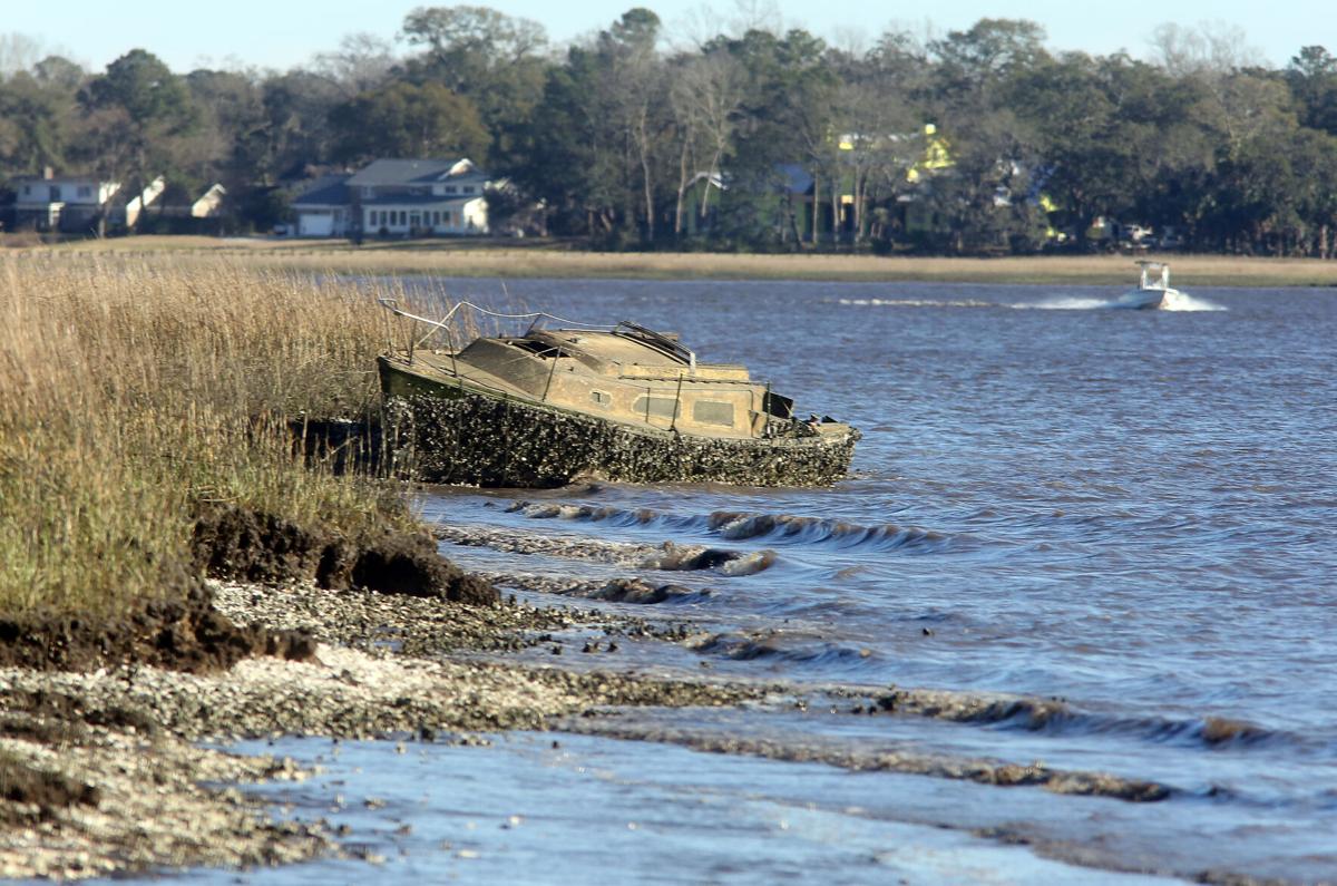
      Boaters have long used South Carolina’s public waterways to store or abandon their derelict vessels. If a new bill passes in the General Assembly, they may soon have to take responsibility for them.


      An abandoned sailboat rests in the pluff mud of the Ashley River near the Interstate 526 Westmoreland Bridge on Tuesday, February 16, 2021. Brad Nettles/Staff


      Charleston legislators introduce bill to crack down on abandoned boats in SC waterways
      Post and Courier

      Be the first to comment!

    • Warning on Dewees Inlet north of Charleston, SC, near AICW Statute Mile 455


      Between the Winyah Bay Entrance south of the AICW from Georgetown, SC and the Charleston, SC harbor entrance, there is really no safe inlet and Dewees Inlet carries this emphatic warning from Claiborne: WARN ANYONE OFF FROM USING THIS INLET. THERE IS NO CHANNEL TO SPEAK OF AND TO SAY IT’S TREACHEROUS IS AN UNDERSTATEMENT. IT COULD BE DEADLY!!!

      We are headed back off-shore to the south – Charleston, but would prefer Isle of Palms as it takes about two hours off the trip… if we can get in through Dewees Inlet. Charts show no marked channel to the outside but inside the water is charted deep (no channel markers), tides run 5+ feet and there are some tempting areas that may not be shoaled up. Does anyone know if this passage can be made safely with a ~6 ft. draw at HT? Thanks
      Captain Ric

      Click Here To Open A Chart View Window Showing the Location of Dewees Inlet

      Comments from Cruisers (1)

      1. Tom Duckett -  November 20, 2020 - 9:03 pm

        I know this is 10 years after the original post, but stay away from Dewees Inlet! Navionics had me take the outside route from McClellanville to Isle of Palms this morning because of low tide along the ICW. Well, I can tell you first hand that Dewees Inlet made me soil my shorts and need a few beers once inside. The approach consisted of many turns and following that magenta line to the "T". However, there was a northeast wind with swell coming from the northeast and the south. Everything was going fine, I was on the line and then my depth sounder started screaming low water. I draw 4'9" on my 37' Gulf Star and at 6' on the sounder with the swell, I kissed the bottom with the keel twice before finding deep water 100' to starboard (off the magenta line) on the edge of breaking waves. Halfway in I saw two large 40+' sport fishing boats turn around and say "Nope, not today". Water depth went from 30' to 6' in a matter of 100 yards and then back to 30+'. Once in calmer water, there was 40' depths the rest of the way. What a way to test the nerves of a new Captain. Next time, I'll take my chances running aground in the ICW. On a calm day, you might be able to get in or out of here, but I seriously don't suggest trying it.

        Reply to Tom
    • LNM: Wave Buoy Deployment, Charleston Harbor Entrance Channel, near SC AICW Statute Mile 465


      This wave buoy is on the SSW side of the entrance channel.

      SOUTH CAROLINA – CHARLESTON ENTRANCE – CHARLESTON HARBOR: Post 45 Charleston Entrance Channel Maintenance Wave Buoy Deployment
      Great Lakes Dredge & Dock Company, LLC has deployed a data buoy in the approximate work area of the Charleston Entrance Channel Dredging Projects to monitor sea conditions for the purpose of supporting safe dredging operations offshore. The wave data buoy will be anchored/tethered to the sea floor with approximately 130 feet of chain, the exact position of the buoy is dependent on local tides and currents. The wave buoy is also equipped with AIS. AIS ID is GLD-HB1. Mariners and vessels operating are advised to remain clear of the area. For further information, contact Great Lakes Dredge & Dock Company, John Huit at (630) 207-5196. Chart 11528 LNM 33/20


      Be the first to comment!

    • Masks Required in Charleston, SC Beginning July 1


      Charleston’s city council voted Thursday night to require people wear masks in public places beginning July 1. Enforcement will be difficult in a state that values individual freedom over community welfare.

      Charleston votes to require masks as county leads SC in new coronavirus cases


      AREA SPONSORING MARINAS!

      Click Here To View the South Carolina Cruisers Net Marina Directory Listing For Charleston City Marina

      Click Here To Open A Chart View Window, Zoomed To the Location of Charleston City Marina

      Click Here To View the South Carolina Cruisers Net Marina Directory Listing For Charleston Harbor Marina

      Click Here To Open A Chart View Window, Zoomed To the Location of Charleston Harbor Marina

      Click Here To View the South Carolina Cruisers Net Marina Directory Listing For Cooper River Marina

      Click Here To Open A Chart View Window, Zoomed To the Location of Cooper River Marina

      3 Facebook Likes, 3 Facebook Reactions

      Comments from Cruisers (1)

      1. james aughton -  June 26, 2020 - 5:41 pm

        What makes the author believe that "enforcement will be difficult"? I think most citizens of SC will think it is no big deal to wear masks if only for the benefit of their neighbors

        Reply to james
    • Outboard Service Available! Safe Harbor City Boatyard, Charleston, SC


      Safe Harbor City Boatyard, formerly Charleston City Boatyard, a subsidiary of Safe Harbor Marinas, A CRUISERS NET SPONSOR, is found on the northern reaches of the Wando River north of red marker #40. 

      Click for details on Outboard Service Available!

      Click Here To Open A Chart View Window, Zoomed To the Location of Safe Harbor City Boatyard

      Click Here To View the South Carolina Cruisers Net Marina Directory Listing For Safe Harbor City Marina

      Click Here To Open A Chart View Window, Zoomed To the Location of Safe Harbor City Marina

      Be the first to comment!

    • Simplifying Your Boating Experience, Safe Harbor Charleston City Marina, SC AICW Statute Mile 469


      One of a number of Safe Harbor Marinas along the Intracoastal Waterway, Safe Harbor Charleston City Marina, A CRUISERS NET SPONSOR, is located along the Ashley River’s northeastern banks, northeast of marker #5.

      Simplifying your boating experience | Introducing ePay

      Click Here To View the South Carolina Cruisers Net Marina Directory Listing For Safe Harbor Charleston City Marina

      Click Here To Open A Chart View Window, Zoomed To the Location of Safe Harbor Charleston City Marina

      Be the first to comment!


    Social Media Auto Publish Powered By : XYZScripts.com