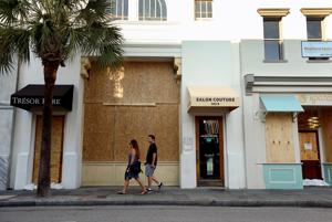
3:45 p.m. storm update: Charleston deals with ‘incredible flooding,’ tornado warnings
| ||||||||||||
|
| ||||||||||||
|
| ||||||||||
|
From scemd.org
You will need to bring these items with you to any emergency shelter:
| County | Shelter Name | Address | Status | Pet Friendly |
|---|---|---|---|---|
| Colleton | Colleton County Middle School | 1379 Tuskegee Airmen Drive | OPEN | |
| Jasper | Ridgeland High-Junior-Elementary Complex | 250 Jaguar Trail | OPEN | |
| Richland | Dent Middle School | 2721 Decker Blvd | OPEN |
| ||||||||||
|
McMaster orders Saturday evacuations of some barrier islands
| ||||||||||||||
|
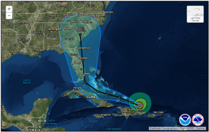
Record surge, ‘major’ storm conditions expected in South Carolina from Hurricane Irma
Surf will start to pick up Thursday, winds and rain by Saturday night. Hurricane Irma is due to make landfall in or near South Carolina late Monday or early Tuesday.
from Post and Courier, Charleston, SC
| ||||||||
|
Pierside Boatworks is now Charleston Boatyard Marina!
Pierside Boatworks has sold and is now operating as Charleston Boatyard Marina, LLC. New owners and boat enthusiasts Andy Oberdier and Peter Ulber are ready to transform it into Charleston’s modern and easy to use Boatyard. We are excited to keep you up to date on all the latest developments and plans.
If you are interested in contacting us for service, questions, or just to say hi, please contact us!
Call us at the same number: 843-554-7775
Email us for service: service@charlestonboatyard.com
VIsit us on the web: www.charlestonboatyard.com
We will be revamping our website and Facebook page shortly. Also look for promotions and discounts arriving soon.
Paige Haines
READ MORE
Click Here To Open A Chart View Window, Zoomed To the Location of Charleston Boatyard
The information is incorrect. Pierside closed its operations. Charleston Boatyard operates at the location that Pierside used to operate. Charleston Boatyard is not Pierside.
The Harborage at Ashley Marina lies along the northeastern shores of Ashley River (on the Charleston peninsula) between the charted 56 foot fixed bridge and the 18-foot Highway 17 bascule bridge. Initial findings indicate that this fire was related to fueling.
CHARLESTON, SC (WCSC) –
Authorities are working to figure out what caused a boat to explode and catch fire at the Harborage at Ashley Marina Monday morning.
CLICK HERE FOR REPORT AND VIDEO from live5 news.com
Click Here To Open A Chart View Window, Zoomed To the Location of The Harborage at Ashley Marina
Not good but at least is was close to face dock. Hope no one was aboard.
This incident confirms the wisdom of advice always given by the USCG to stand clear of dredge equipment. Dredging in the southern Waterway has become so common that boaters often ignore published warnings of less easily seen dredge equipment in support of the clearly visible dredge vessel.

News Release
April 9, 2017
U.S. Coast Guard 7th District PA Detachment Jacksonville
Contact: Coast Guard PA Detachment Jacksonville
Office: (904) 714-7606/7607
After Hours: (305) 318-1864
Coast Guard rescues 3 boaters after accident near Ravenel Bridge
CHARLESTON, S.C. — The Coast Guard rescued three boaters Sunday after their vessel struck a dredge near the Ravenel Bridge.
Coast Guard Sector Charleston Command Center watch standers received a notification of a boater whose vessel struck a dredge ejecting two boaters into the water at 12:24 a.m.
A Coast Guard Station Charleston 29-foot Response Boat–Small boatcrew launched and an MH-65 Dolphin helicopter crew in the area diverted to assist. Two Charleston County Sheriff marine units also responded.
The RB–S boatcrew arrived on scene at 12:47 a.m. and recovered one boater who was sitting on top of the dredge. A Charleston County Sheriff marine unit recovered the other two boaters.
The three boaters were transported to the Charleston Maritime Center where EMS were waiting.
The condition of the boaters is unknown at this time and South Carolina Department of Natural Resources is conducting an investigation.
And from Charleston’s Post and Courier:
Three rescued after boat crashes into dredge pipe near Ravenel Bridge
By Angie Jackson ajackson@postandcourier.com Apr 9, 2017 Updated 12 hrs ago (0)
Three boaters were rescued early Sunday after their vessel struck a dredge pipe in the Cooper River near the Arthur Ravenel Jr. Bridge, according to the U.S. Coast Guard.
CLICK HERE FOR THE FULL REPORT
Click Here To Open A Chart View Window, Zoomed To the Location of Ravenel Bridge
Click Here To Open A Chart View Window, Zoomed To the Location of Charleston Harbor Marina
Wounded Nature-Working Veterans organizes cleanups to address the many wildlife critical coastal areas that have never been cleaned. If you would like to volunteer and if you have a suitable boat (see below), the next scheduled cleanup is April 22.
Public beach and roadside cleanups benefit the travel & tourism Industry. Our coastal cleanups benefit wildlife. 
Improving South Carolina’s Seafood Population and Production!
On March 25th, 2017, Boeing, Bosch, Charleston Southern University Women’s Volleyball Team, SC Department of Natural Resources, Fish and Wildlife Service and the general public worked with Wounded Nature – Working Veterans to make a real coastal difference.
Trash and debris that poison, entangle and injures marine wildlife was removed from Charleston Harbor. In place of the trash and debris, an oyster bed that we started laying last year, was extended and has begun filtering the water around this island.
Getting wet, dirty, smelling like pluff mud, feeding the mosquitoes, gnats and flies, acquiring some scratches, scrapes and cuts is just a small part of what these volunteers endured to make a real coastal difference.
Cleanup news
Coastal Cleanup April 22nd, 2017
Capers Island
Low tide is 11:23. Wounded Nature boats should leave the ramp around 8:30 and spend several hours removing trash and debris from the high tide line area.
Meeting location:
We will be launching from the Buck’s Hall Boat Ramp. We will be performing this coastal cleanup in conjunction with the Power Boat Squadron.
Currently, we cannot take on any additional volunteers for this project unless they have a boat and are willing to return with some trash and debris in their boat.
Overnight primitive camping on the beach will be available with a permit from SC DNR. Permits available at: http://www.dnr.sc.gov/mlands/specregshp.html
At Wounded Nature-Working Veterans we organize cleanups to address the many wildlife critical coastal areas that have never been cleaned. Most areas can only be accessed by boat. For us, there is no need to further study the problem, we are focused on remedial action and getting tons of trash and debris removed from our coastal areas. We do make a real difference! Our work results in increased fish and shellfish populations and reduced debris deaths for dolphins, manatees, sea turtles and endangered coastal wildlife.
Small personal donations allow us to carry out our greatly needed mission!
This extension of the Wappoo Creek wake zone is between the HWY 30 Connector Bridge at Mile 470 and the Wappoo Creek Bridge at Mile 471, an open stretch of water bordered by a number of homes and docks. Wappoo Creek joins Elliott Cut to connect the Ashley River and the Stono River south of Charleston. See History of Wappoo Creek for more on this area.

Wappoo wake zone to be extended
Wappoo ICW

Wappoo Creek looking north from HWY 17 Bridge
Due to increased boating traffic, the South Carolina Department of Natural Resources (SCDNR) is extending the Wappoo wake zone of the Intracoastal Waterway in Charleston County.
The seasonal wake zone will be extended north to about 200 yards south of the James Island connector bridge, and south to the entrance of Coburg Creek. The extension will be in effect April 15, 2017, through Sept. 15, 2017. The normal wake zone will remain in effect until April 15 and will start again after Sept. 15.
This is one of the busiest stretches of water within the entire state, and law enforcement wants to minimize the risk for accidents.
“This is a popular area because there are two public boat landings within one mile of each other,” SCDNR Cpt. Donnie Pritcher stated. “The traffic has grown tremendously over the years and we want to keep people safe.”
For questions regarding the wake zone extension, contact the SCDNR law enforcement investigations office at 843-953-9378.
Click Here To View the South Carolina Cruisers’ Net Bridge Directory Listing For Wappoo Creek Bridge
Click Here To Open A Chart View Window, Zoomed To the Location of Wappoo Creek Bridge
Our thanks to Tommy Bessinger for this question to which I am sure many boaters who have fought the opposing swift current through Wappoo Creek – Elliott Cut will have answers and opinions – no profanity, please! Elliott Cut is a short, narrow Waterway channel through a residential neighborhood of high steep banks connecting the Ashley River with the Stono River. Although references are made to “Wappoo Cut” and “Elliott Cut” as early as the 1770’s, Wappoo Creek, as charted, west of the Ashley River, becomes is a winding shallow creek running north of Elliott’s Cut. Elliott’s Cut, named for William Elliott, was dredged to bypass the twists of Wappoo Creek and was dredged to the current depth in the late 1880’s as part of the Intracoastal Waterway Project. Historians, please add your two-cents or more to help allay Tommy’s questions!
I live on Elliott’s Cut in the neighborhood of Edgewater Park. Lived here most of my life. I have looked and I cannot find any of the history of the construction of Elliott’s Cut and how and when it came to be. Can anyone please point me in the right direction for information please? Thank you!!!
Tommy Bessinger
References from Google:

http://riverspoint.net/jihistth.pdf
Leaving Charleston Harbor south, the Intracoastal Waterway passed from the Ashley River through the Wappoo Cut and continued along a sinuous string of tidal streams and land cuts 66.5 miles to the Beaufort River at Beaufort, South Carolina. Better than the segment to the north of Charleston, the existing inland water course from Charleston to Beaufort had a minimum depth of six (6) feet, interrupted at only four locations, and, except for a six (6) mile passage across the St. Helena Sound, was well protected from the sea.
Earlier work on this segment of the waterway tackled its most problematic stretches. The first undertaking was at Wappoo Cut, a crooked and shallow creek that joined the Ashley and Steno rivers. By dredging and by a cutoff bypassing some of the worst bends, a project authorized in 1881 created a channel through the cut six (6) feet deep and sixty (60) feet wide. At the other end of this segment, a project adopted in 1890 improved Brickyard Creek. A continuation of the Beaufort River, Brickyard Creek had a fairly good seven (7) foot channel except near its juncture with the Coosaw River, where the channel practically disappeared among shoals. Work completed in 1905 provided the creek with a constant seven (7) foot depth and “convenient width.” A third improvement, made in 1905-1906, was the construction of Fenwicks Island Cut in the central portion of this segment. It replaced a narrow, tortuous, and shallow passage through Mosquito Creek – the cut, seven (7) feet deep and ninety (90) feet wide, connected the South Edisto River with the Ashepoo River.
J.D. Lewis – PO Box 1188 – Little River, SC 29566
http://www.carolana.com/SC/Transportation/sc_icw.html

From The Siege of Charleston 1780 by Gen. Wilmot G. DeSaussure
http://www.clansinclairsc.org/siegecharleston.htm
Click Here To Open A Chart View Window, Zoomed To the Location of the Elliott Cut – Wappoo Creek Section of the AICW

We have received word that following Hurricane Matthew, some changes are necessary at SALTY SOUTHEAST CRUISERS’ NET SPONSOR, Charleston Harbor Marina which sits on the Mount Pleasant side of Charleston Harbor, hard by Patriots Point between Horse Reach’s flashing buoys #34 and #36.
We are now instituting an amenities fee for the transient. Daily will be $18, Weekly will be $90, and monthly will be $300. The current list is below.
Kelley
· -24 hour full service marina / 24 hour security
· -Protective breakwaters and Wide floating docks
· -6 pack Charter service available
· -Clean facilities, shower and laundry
· -Wireless Internet Access
· -Access to Harborside pool and Jacuzzi
· -10% off all food & beverage purchased at the Harborside Hotel & Fish House with marina card
· -10% off rooms at the Harborside Hotel with marina card (Except Blackout Dates)
· -10% off Purchases at the Marina Store with the marina card
· -Easy access to Charleston’s #1 beach party, Party at the Point, as well as other events
· *Be sure to ask about our Tenant Referral program
· -Additional Beach Club Amenities
· Unlimited access – year round- to our heated pool(s) with complimentary towel service and poolside cabanas when open.
· Food and Beverage service at the Tiki Bar and Grille or your private cabana
· Use of all Pool amenities including life-sized chess board, bocce ball court and fire pits
· Exclusive invitations to resort hosted events like Party at the Point, Bazaar at the Point, Winterfest, Smoke on the Harbor, Burgers Bands and Brews, & Oyster Roasts, etc. Complimentary admission to these events for registered pool members and their dependents.
· Access to book the Beach Club’s private event space (board room, private movie theatre, yacht club) for member hosted events.
L. Kelley Poe
Director of Marina Operations
Charleston Harbor Resort & Marina
24 Patriots Point Road
Mount Pleasant, SC. 29464
Tel : 843.284.7065
KPoe@CharlestonHarborResort.com
www.CharlestonHarborMarina.com
www.charlestonharborfishhouse.com
Click Here To Open A Chart View Window, Zoomed To the Location of Charleston Harbor Marina
I wonder if we get reduced rate if the internet does not work well out on the docks like in the past?
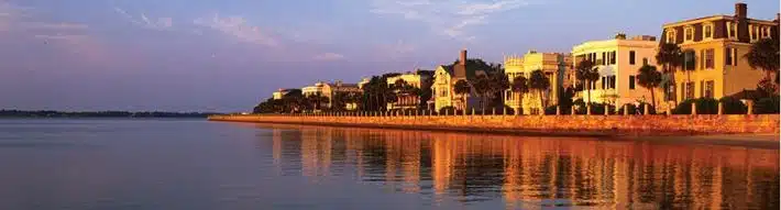
Charleston City Marina, A SALTY SOUTHEAST CRUISERS’ NET SPONSOR, is located along the Ashley River’s northeastern banks, northeast of marker #5, and only a hop, skip and jump from the path of the AICW!
The City Marina was the winner in the Marina category of the Post & Courier’s 2016 Charleston’s Choice Awards. It is a well-deserved honor.


Click Here To Open A Chart View Window, Zoomed To the Location of Charleston City Marina


This Post and Courier article on Charleston was proudly – and justifiably so – submitted by David Rogers of City Marina, A SALTY SOUTHEAST CRUISERS’ NET SPONSOR. Charleston is also home to another SSECN SPONSOR, Charleston Harbor Marina at Patriots Point.
|
Click Here To Open A Chart View Window, Zoomed To the Location of Charleston City Marina
Click Here To Open A Chart View Window, Zoomed To the Location of Charleston Harbor Marina
Longtime cruiser and SSECN Contributing Editor, Captain Jim Healy, shares his knowledge and experience in these observations on this portion of the Atlantic Intracoastal Waterway. Thank you Jim!
Contributing Editor, Captain Jim Healy, shares his perspective on Charleston and Beaufort, SC and Savannah, GA where several SALTY SOUTHEAST CRUISERS’ NET SPONSORs are located. Thank you Jim!
Charleston, SC and Savannah, GA: magnificent old southern cities with many points-of-
 boat and pleasure craft. There are several architecture tours in both cities, and both have lots of weekly and seasonal activity for visitors. From Savannah (there are marina options in downtown Savannah on the Savannah River or at Thunderbolt and Isle of Hope), boaters can also visit Tybee Island (light house and Fort Pulaski).

Jim Healy
Click Here to read – and hear- this report from Hawaii Public Radio. Look for them as you migrate north!
Voyaging Canoe Hokulea Navigates Florida Waterways
By MOLLY SOLOMON • 4 HOURS AGO

CREDIT OIWI TV / MAUI TAUOTAHA
Voyaging canoe Hōkūle‘a is continuing her journey up the East Coast of the mainland. The canoe recently left Titusville, Florida and is traveling along the Intracoastal Waterway, where she’s encountered new wildlife and a whole lot of aloha.
HPR’s Molly Solomon checked in with navigator Bruce Blankenfeld as part of our ongoing coverage Hōkūle‘a: Voyage of Aloha.
Hōkūle‘a’s next stop is Charleston, South Carolina — then it’s on to Virginia and New York in June.
April 14, 3:30PM
Hokulea approaching Charleston Maritime Center

The crew of Hokulea was greeted by a contingent of native Hawaiians who now live in the Charleston area. The greeting included drumming and conch blowing.

Drummers
Awesome! Incredible journey! Hope she is stopping in Beaufort. Watching the icw cam @ Wrightsville bridge for another wonderful glimpse of unique, untold, maritime history!!

Charleston City Marina is welcoming its transient guests with a free Happy Hour on the Megadock Monday, Tuesday, Thursday and Friday evenings with live music on Thursdays beginning in May. Charleston City Marina, A SALTY SOUTHEAST CRUISERS’ NET SPONSOR, is located along the Ashley River’s northeastern banks, northeast of marker #5.

Click Here To Open A Chart View Window, Zoomed To the Location of Charleston City Marina

Very nice, clean facility. Friendly and helpful staff. Convenient location. Grocery, drug stores and restaurants close by with courtesy car provided. Current can be tricky when tide is running,, but staff will assist with lines when docking. Will stop here again and recommend it highly to others.
Capt Jack B-H and 1st mate Steve O.
Aboard the trawler “Whatever”
Click Here To Open A Chart View Window, Zoomed To the Location of St. Johns Yacht Harbor


Be the first to comment!