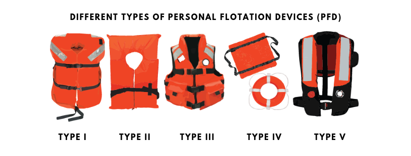
Before getting in the water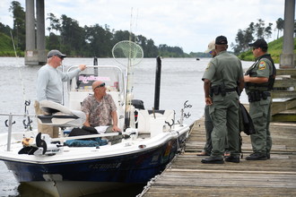 Before leaving, make sure you fill out a float plan and let people know where you’re going, what route your taking, as well as what time you expect to be back. You can download the United State Coast Guard app to fill out your float plan and share it electronically. You’ll also want to get all your Personal Flotation Devices (PFD) together, make sure they are in serviceable condition AND are the correct size for all passengers, especially children. All PFDs should be stamped with “U.S. Coast Guard Approved” and include the type of PFD it is. There are five PFD types: - Type I: Offshore Life Jackets:
- Best for all waters where rescue may be delayed and will turn unconscious wearers to face-up position
- Type II: Near-shore Vests:
- Best for calm, inland water where a quick rescue is likely.
- Type III: Floatation Aids:
- For general boating or the specialized activity, such as water skiing, hunting, fishing, canoeing, kayaking and others. Good for calm, inland waters, or where there is a good chance for fast rescue.
- Type IV: Throwable Device:
- Can be a square style, or a ring buoy or horseshoe buoy mounted on deck.
- NOTE– You must have one at arm’s length to throw over the side in an emergency.
- Type V: Special-use Devices:
- Manual units are activated by yanking a pull-tab. Both types, Hybrid inflation and Automatic inflation, of inflatables feature blow-tubes to provide a back-up method of inflation.
|
 |
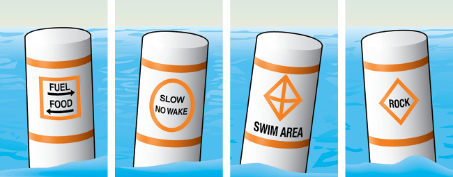
You should also check your fuel level and battery charge before heading out. If possible, have an extra battery for your boat. Make sure your lights are in good working condition on the boat AND trailer, as well. In addition to PFDs, you’ll also need to have a fire extinguisher readily accessible and in good serviceable condition. Also, remember to put the plug in. On the waterNow that all that is checked-off, what should you know when you’re on one of South Carolina’s beautiful waterways? The first thing you should do is get familiar with the aids to navigation and buoy system in the area you’ll be in. Refresh your memory on what each symbol and color means. Lateral markers will mark the edges of safe water areas, directing traffic within a channel. Think of them as the yellow lines you see on the road. A red marker indicates the right side of the channel, and green will be the left side as a boater heads upstream or enters from open sea. Remember, all boats approaching from the right have the right of way and should keep the course. Non-lateral markers are navigational aids that give information other than the edges of safe water areas. The most common are regulatory markers which are white and use orange markings and black lettering. Non-lateral markers are found on lakes and rivers. - Information: Squares indicate where to find food, supplies, repairs, etc., and give directions and other information.
- Controlled: Circles indicate a controlled area such as speed limit, no fishing or anchoring, ski only or no skiing, or “slow, no wake.”
- The “no wake” zones will be marked by an official SCDNR logo
- Exclusion: Crossed diamonds indicate areas off-limits to all vessels such as swimming areas, dams, and spillways.
- Danger: Diamonds warn of dangers such as rocks, shoals, construction, dams, or stumps. Always proceed with caution.
While you can be prepared as much as possible, it won’t always stop something bad from happening. However, being prepared could keep the situation from being worse. If someone does fall overboard, immediately turn the boat off and throw something that will float, like a PFD, raft or cooler to the person. You should have it easily accessible and not tied down. If your boat capsizes, stay with the boat! You will have a better chance of being seen by rescue crews. South Carolina has the perfect conditions for pop-up thunderstorms during the summer. If you get caught in one, head into the wind and have everyone, including yourself, put on PFDs. Also, keep passengers low in the boat. Don’t operate any watercraft while under the influence of alcohol or drugs. If you see any potential boating, fishing or hunting violations, call Operation Game Thief’s 24-hour hotline at 1-800-922-5431 to report it. |


Be the first to comment!