Cruising Western Florida’s Big Bend Region
Although most “loopers” seem to bypass the Big Bend, we are interested in actually experiencing some of the old Florida areas that are apparently still very much alive and well, if water depth and weather permits.
Sanderling is currently in Carrabelle at the C-Quarters marina while we’re enjoying a few months at home. We want to resume our cruise homeward to Merritt Island once the winter winds subside and water levels return to near “normal,” temps warm up, and daylight is longer – probably March.
We have visited St. Marks, Steinhatchee, and Cedar Key by car on our way to and from Sanderling, and would like to visit all three on our way around the Big Bend to Tarpon Springs. Might also consider Crystal River.
At least one boater has visited both St. Marks and Steinhatchee in a DF 49 with a 5 foot draft (our DF 41 is 4 feet).
Has anyone cruised into those three areas (St. Marks, Steinhatchee, Cedar Key) or Crystal River in a boat with 4+ foot draft, and what was your experience with the water depths and anchorages/marinas?
Any thoughts or suggestions welcome!
Judy Young & Bob McLeran
When we were in Carrabelle my assessment was that the northerly winds that are favorable to leave will also blow or the water in those ports. I was trying hard to avoid the long overnight run and kept looking at all options very seriously.
I was warned by the guys at C Quarters that Steinhatchee entrance can get quite shallow even on a good day. They tried to talk me out of going there. Then add to it the effect of the North wind which will make it even lower. I saw it as a crap shoot and decided against putting myself in that potential situation.
I chose the overnight crossing and went straight to Clearwater instead of Tarpon Springs. It was a small additional time but there are far less crab pots approaching Clearwater.
Left the bay near Carrabelle at noon and arrived at the Wrights at 3rd next day.
R.
We had a DeFever 44+5 with a 4′-7″ draft (5′ w/Admiral’s stuff). Cannot attest to the depths now, but we went into St. Marks in May of 2006 & had no problems. Also, no problems with Steinhatchee & Cedar Key in December of 2007. Best I remember we went into both places on a rising tide. Never did go into Crystal River, but had friends that have been in there with 4′-6″ draft & had no trouble.
Don’t believe I would make the trip today into any of those places until the wind blows the water back into the bays.
Eddie Lomenick
Eagle’s Nest
Leaving for the Big Bend in March is a good plan, better later in the month once the prevailing winds shift back to the southeast. That will return your channels to their charted depths. Ideally, you can leave one port and arrive in the next at high tide to reduce the margin of risk. Those tides are about 13 hours apart and if you hit the time just right, you can ride your departing high tide all down the coast. I have been through the Big Bend in a 4 foot draft sailboat and this strategy worked well. April would even work better for you.
Stay safe,
Tom
I’ve been in and out of a few but not all of these places. I think that if you can plan your arrival or departures around the tides you will be OK with 4′ draft and a single screw. The problem is that north winds blow all the water out and if you are unlucky enough to combine that with spring lows your draft will most assuredly exceed your depth.
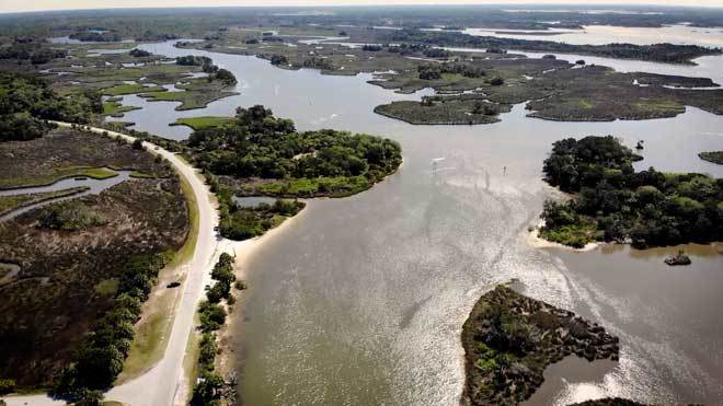
Crystal River is typical of many Big Bend rivers. It is about eight miles in (and back out) from the Gulf, which makes the day’s travel a couple hours longer than you might think.
Regards,
Randy Pickelmann
Morning Star
We have cruised the Big Bend several times in Silver Boots drawing five feet with stops at Steinhatchie and Cedar Key.
We have found we need one foot above winter low tide to enter the Steinhatchie channel. There is one floating green channel marker and this is the low spot. We have stayed at the Sea Hag marina.
We have entered Cedar Key from both north and south and do not suggest the north west channel because of shoaling. At high tide we have scraped bottom. The south Main Ship channel has plenty of depth but becomes tricky as you approach the intersection with the north west channel. Study the charts carefully and understand the zig zag route you will follow. No marina and very little protection in this anchorage.
Jim & Pam Shipp
aboard Silver Boots
Steinhatchee, FL. is our hailing port , we sail in and out frequently. We have two sailboats there a 50 ft. Gulf Star Texas, and a Islander 36 that both draw six feet. As long as you keep it in the channel there is no problem navigating in and out here. We’ve also been in and out of Crystal River a few times with these vessels. You need a good peak high tide going in as there is a shallow sand bar to cross, or there was last time we went in?
Fair Winds,
R. Bideaux
La victoria
To me, the draft of your boat is the biggest consideration. My boat draws 5 feet and I always cut across, usually from Carravelle to Clearwater, or vice versa. If you are not in a hurry, don’t just wait for the weather, wait for a night with a full or nearly full moon, and it will make the night passage a lot more fun. It’s an easy one nighter.
With less draft, there are several places that would be fun to stop and visit.
R. Holiman
For boats planning to arrive Crystal River – We live in Crystal River and home port our 44′ Island Gypsy here. We draft 4.5 feet. With the low tides we are having now, we only move at near high tide and even then there are several areas in the river that we clear with only 2.5 feet under the keel. The river will lull you with stretches of 12-14 feet and suddenly 2 to 3 feet under your keel – go slow. The channel inbound from CR1 to Shell Island also has several areas with the same depths so from CR1 to Kings Bay needs to be done slowly. Things will improve with the arrival of spring tides but for now deeper draft boats should exercise caution and only transit at high tide.
Doug & Virginia Hall M/V Lotus
WE have sailed the St. Marks/Shell Point area for years. St. Marks is not problem, the channel is dredged for large fuel barges and has plenty of water. Shields Marina is a very nice facility and anchoring well up the St. Marks river is a wonderful wilderness experience. There is plenty of water up the river to the large powerlines that cross just south of US 98 bridge. The St. Mark’s wildlife refuge borders the east side of the river and the flloodplain on the west has a few docks and houses, but you cannot see most of the houses. When anchor overnight you are usually alone are with light traffic and you really think you are in a jungle. This is truly an undiscovered part of the big bend. Try the Riverside restaurant which has music most weekends and a transient dock.
Phil Werndli
MSV Banana Wind


Be the first to comment!