UPDATE/CRYSTAL RIVER TO HORSESHOE POINT/ATON/SEC SSP BNM 0174-26 UPDATE-1
CEDAR KEYS NORTHWEST CHNL DBN 21 (LLNR 30005) IS TRLB. ALL MARINERS ARE ADVISE TO TRANSIT THE AREA WITH CAUTION. CANCEL AT//182359Z MAY 26//
BT
This email was sent to curtis.hoff@CruisersNet.net using GovDelivery Communications Cloud on behalf of: U.S. Coast Guard · U.S. Department of Homeland Security · Washington, DC 20528 · 800-439-1420
*** THIS DIV IS AUTOMATICALLY HIDDEN WHEN DISPLAYED – INFO FOR DEBUGGING PURPOSES *** ***MANUALLY DO: FIX TITLE, EXPIRE DATE, CATEGORIES, ENABLE SOCIAL POST *** 0: llnr: 30005 District: 07 lat/lon: 29.119311,-83.049886 Desc: Cedar Keys Northwest Channel Daybeacon 21
SAFETY/CRYSTAL RIVER TO HORSESHOE POINT/ATON/SEC SSP BNM 0174-26
CEDAR KEYS NORTHWEST CHNL DBN 21 (LLNR 30005) IS RPTD MISSING. ALL MARINERS ARE ADVISED TO TRANSIT THE AREA WITH CAUTION. CANCEL AT//152359Z MAY 26//
BT
This email was sent to curtis.hoff@CruisersNet.net using GovDelivery Communications Cloud on behalf of: U.S. Coast Guard · U.S. Department of Homeland Security · Washington, DC 20528 · 800-439-1420
*** THIS DIV IS AUTOMATICALLY HIDDEN WHEN DISPLAYED – INFO FOR DEBUGGING PURPOSES *** ***MANUALLY DO: FIX TITLE, EXPIRE DATE, CATEGORIES, ENABLE SOCIAL POST *** 0: llnr: 30005 District: 07 lat/lon: 29.119311,-83.049886 Desc: Cedar Keys Northwest Channel Daybeacon 21
STEINHATCHEE RVR DBN 23 (LLN 30530) HAS BEEN REPORTED DESTROYED. ALL MARINERS ARE ADVISED TO TRANSIT THE AREA WITH CAUTION.
CANCEL AT//102359Z MAY 26//
BT
This email was sent to curtis.hoff@CruisersNet.net using GovDelivery Communications Cloud on behalf of: U.S. Coast Guard · U.S. Department of Homeland Security · Washington, DC 20528 · 800-439-1420
*** THIS DIV IS AUTOMATICALLY HIDDEN WHEN DISPLAYED – INFO FOR DEBUGGING PURPOSES *** ***MANUALLY DO: FIX TITLE, EXPIRE DATE, CATEGORIES, ENABLE SOCIAL POST *** 0: llnr: 30530 District: 07 lat/lon: 29.667433,-83.410946 Desc: Steinhatchee River Daybeacon 23
HOMOSASSA RIVER BOUY 63 (LLNR 28600) IS RPTD OFFSTATION AND A HAZNAV. ALL MARINERS ARE ADVISED TO TRANSIT THE AREA WITH CAUTION. CANCEL AT//052359Z MAY 26//
BT
This email was sent to curtis.hoff@CruisersNet.net using GovDelivery Communications Cloud on behalf of: U.S. Coast Guard · U.S. Department of Homeland Security · Washington, DC 20528 · 800-439-1420
*** THIS DIV IS AUTOMATICALLY HIDDEN WHEN DISPLAYED – INFO FOR DEBUGGING PURPOSES *** ***MANUALLY DO: FIX TITLE, EXPIRE DATE, CATEGORIES, ENABLE SOCIAL POST *** 0: llnr: 28600 District: 07 lat/lon: 28.780244,-82.655219 Desc: Homosassa River Buoy 63
HOMOSASSA RIVER BOUY 37 (LLNR 28475) IS RPTD OFFSTATION AND A HAZNAV. ALL MARINERS ARE ADVISED TO TRANSIT THE AREA WITH CAUTION. CANCEL AT//052359Z MAY 26//
BT
This email was sent to curtis.hoff@CruisersNet.net using GovDelivery Communications Cloud on behalf of: U.S. Coast Guard · U.S. Department of Homeland Security · Washington, DC 20528 · 800-439-1420
*** THIS DIV IS AUTOMATICALLY HIDDEN WHEN DISPLAYED – INFO FOR DEBUGGING PURPOSES *** ***MANUALLY DO: FIX TITLE, EXPIRE DATE, CATEGORIES, ENABLE SOCIAL POST *** 0: llnr: 28475 District: 07 lat/lon: 28.771007,-82.694189 Desc: Homosassa River Buoy 37
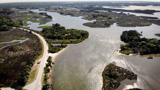
The entrance to Withlacoochee River is a long, narrow, multi-marker channel. This new technology will assist boaters wanting to explore the beautiful Withlacoochee.
This is one of Claiborne’s early posting and today TJ Palmerton has questions for you, in the comments below.
I’ve copied the discussion below from the Net’s “Ask Your Neighbor” page, and the AGLCA mailing list. The never completed Florida Barge Canal pierces the Big Bend portion of the Western Florida coastline north of Crystal River, and short hop south of the western entrance of the Withlacoochee River. I have never tried anchoring here, but after reading the messages below, it looks like a real possibility!
Does anybody have recent information regarding access, depths and anchoring in the abandoned Cross Florida Barge Canal instead of going up to Yankeetown or Crystal River. This would mean continuing straight into the Barge Canal at G 23 instead of turning NE up the Withlacoohee River toward Yankeetown as mentioned in “Skipper Bob”. Chuck and Barbara Ganem “Gold Watch”
We anchored twice in the CFBC – once in 2008 and again in 2009. We need 4.5 feet of water and had no problem with depth. As I remember, it was 7-9 feet. The CFBC is well-sheltered from winds and has otters, dolphin, and bald eagles. Small (fast) boats use the CFBC to get to/from the boat ramp by the bridge, but the traffic is light and almost non-existent after dark. One caution, in 2009, we started to anchor a mile from the entrance (where we anchored in 2008) and were stopped by the Coast Guard. They directed us to anchor in the turning basin, which is maybe a mile east of the bridge. The turning basin will add about 4-5 miles to your trip (one way). Billy
Thank you for responding to my question regarding anchoring in the CFBC. I have since contacted the park ranger for that area thru a phone number I found on the government chart for that area now called the Cross Florida Greenway. His name is Chris McKenzie. He was very informative about the area and assured me that my draft of 4.5 feet would have no problem in the canal all the way to and including the turning basin which was about 1/2 mile past the highway bridge on the right side of the channel. He recommends that the turning basin is where to anchor and said it provides excellent protection from any direction. He explained that maybe about once every three months a tow and barge uses the canal to transport loads from mining either into or out of the canal. The lowest water depth is at where the canal enters the point of land on the chart. He explained that at low tide the tow captains wait for a rising tide to pass this point with a loaded barge, but for a 4.5 ft draft this should be no problem. This anchorage appears to be easier access, deeper and less distance than either going up the Crystal River or to Yankeetown but of course is still only an anchorage. Chuck and Barbara Ganem M/V “Gold Watch”
Share:
Comments from Cruisers (3)
Ronald Longman- August 4, 2019 - 11:44 am
As you get close to the non-operational lock the Withlacoochee river comes in from the south. Good depth up to within a 1/4 mile of the dam and spillway. There is no boat access to the Lake. Strong current in this part of the river.. The Withlacoochee is blocked on the north side as it is fed by another spillway on the north side of the lock. I have done both sides of the lock in my 11' Zodiac. Depth is good all the way from the Gulf to the lock.
I am wondering how far up the canal you can go. Can you go all the way up to the locks and is there any way to get past them going a different way around them?
Does anyone know how far that you can go up the canal? I heard that there’s a fresh water lake off to the east to anchor in. I have a 38’ Sea Ray and am curious about the depth all the way up. Thank you, TJ
Destin is on the southern shore of Chocktawhatchee Bay east of Fort Walton. Our thanks to AGLCA Forum friends, Scott and KC Calkin, for sharing this report.
Spoke to Mel and Ann last night. They are at Dog Is. and leave for Steinhatche in am. He reports ICW totally cleared open from Destin east. All nav aids in place. NO debris. Ashore–devastation. Marinas? Pan. City, Port St. Joe and Appalach grim. Fuel–Destin, Sandestin, Carrabelle.
Scott & KC Calkin Jet Stream 466 Carver MY Gold looper going for Platinum U.S. Navy (Ret.), American Airlines (Ret
211 Big Bend is a United Way Agency in the eight-county region of the big bend.
For Assistance After The Storm 2-1-1 Big Bend
Following Hurricane Michael, individuals and families in need can contact 2-1-1 by simply dialing 211 from a cell phone or landline. 2-1-1 is a free, 24/7, hotline available in multiple languages, that provides information to individuals seeking community resources like shelter, food and water, recovery support, short-term counseling and other basic needs before, during and after disasters.
Calls are free, confidential and anonymous. Trained hotline counselors are available to listen and provide emotional support, crisis counseling, suicide prevention, and information.
Dial 2-1-1 or (850) 617-6333 for 24/7 human service information and assistance.
Bilingual and translation services are available. TDD/TTY or 711Florida Relay is available for hearing impaired individuals.
2-1-1 Big Bend, A United Way Agency, is your gateway to human services in the eight-county region of the big bend. 2-1-1 Big Bend is a non-profit 501c3 organization accredited by the Alliance of Information and Referral Systems and the American Association of Suicidality. The agency’s mission is to provide assessment, emotional support, crisis assistance, education, training and referrals with accurate, up-to-date resource info.
Panama City, on the eastern shore of St. Andres Bay northeast of Mexico Beach where Hurricane Michael made landfall, suffered devastating damage from Michael. Panama City Marina and St. Andrews Marina are both CRUISERS NET SPONSORS and our thoughts and deepest sympathies go out to all in the area who sustained losses. Diana Pieper, who sent this report, lost her house.
Panama City Marina GONE….destroyed. St. Andrews Marina had a lot of damage.
We can’t even get in to our home with a u-haul to remove what furniture is salvageable because of the trees down. Our neighborhood was hit harder because of the old oak trees and pine trees that we are famous for. My family and I are staying in hotels until we can find temporary housing of some kind. I wish we had the RV I sold after my husband died. Again, thanks for your concern. The entire city is destroyed or damaged (actually the whole county). Both large hospitals have been closed indefinitely due to extreme damage. Our entire infrastructure is broken. Recovery is in years and not months. Diana Pieper
Except as noted, most of these displays begin at midnight and last about 10 minutes. As usual with night time navigation, great care must taken in the vicinity of anchored spectator boats, especially following the displays.
St. Joseph Bay 10PM Panama City Beach Midnight Mexico Beach Midnight Cinco Bayou 8PM and Midnight Fort Walton Midnight Santa Rosa Sound Midnight Destin Harbor 8PM Mobile Midnight
If you sight this vessel, please contact Tony at 850-851-8619, local authorities or SSECN via email contact@cruisersnet.net.
About two weeks ago, a crewmate stole my 43′ Gulfstar sailing ketch from Panama City Florida. The name of the boat is “The Solution”. She has white hill with red sail covers and red canvas over the cockpit. The guy who stole it is 18 yrs old named Bear McGinty. He has his girlfriend on board with her 6 month old baby boy. Believe they are headed to Galveston Texas. If anyone sees the boat please call me at 850.851.8619. Much thanks, Robert A. (Tony) Hicks
Skipper Spinucci is asking for recommendations of marinas between Clearwater and Port St. Joe. Let us hear from you.
Some help please. I’m planning a trip from Venice, Fl to Orange Beach, Al in June 2016. I have a 315 BW, Conquest with a fuel range of a couple hundred miles depending on the sea’s. I am planning over nighters in Tampa and Clearwater. I need a stop halfway from Clearwater and Port St Joe. The marina must include transient dockage, Restaurants and nearby motels. Needless to say gas also. Any ideas? I’m trying to keep day trips under 125 miles.
This call for a fleet formation of Gulf crossing vessels is from our good friends at AGLCA.
Hey all, We are moving to Panama City today To sort of get in position for our crossing. Since it has been awhile since the weather window opened many of us have taken Eddy’s advice and been slow floating Since getting off of the rivers. Loopers are strung out from Carrabelle back to Mobile. It looks like that when a opportunity finally arrives there will be a whole armada of us moving. It would be nice to know how many, who we are and planned crossing speed. Probably not too early to get a roll call of vessels who are staged intending to cross at the next window since we are at many different ports right now. Our plans a capability:
Panama City until the window is a day or so away. Then Apalachacola or Carrabelle (if there will even be room). If no room we are capable of going direct from Panama City. Boat speed 7 MPH to 25 MPH. Prefer 10 – 20. Charlie and Kay Woodard
Share:
Comments from Cruisers (1)
Gaz- June 7, 2016 - 10:41 am
Charlie & Kay,
Keep in mind that scallop season starts the 25th of June which will be an issue gaining dockage the closer you get to this date. That said there are many nice marinas reminiscent of old time Florida along the Big Bend area. Don’t expect anything fancy but you will receive great friendship and clean accommodations. All the marinas I’ll mention can handle a 3 foot draft and then some. Be cautious of the depth in this area. 1) Swanne River ahs two: Swannee River marina 352 542 9159 & Gateway Marina 352 542 7349 Call the local BoatUS Tow for current channel depths and USE THE NORTH channel NOT the river. 2) Yankee Town; YT marina 352 447 2529; B’s talk with Helen 352-447-5888; Riverside 352-447-2890 This is one of my vavorite stops. 3) Crystal River: Petes’s 352 795 3302 & Twin River 352 795 3552 This area thinks highly of there dock space but if you’ve never been to Crystal River the stop might be nice. 4) Now to my favorite river the Steinhatchee: For a nice motel with dockage call Shelter Cove. They have recently been bought out by Ideal Marine so you can be the first to review them. 352 498 5707/352-210-1781. There are also Good Times Motel never been there 352 498-8088; SeaHag 352 498-3008 lots wakes; River Haven my favorite 352 498-0709/352-356=2904;
This is outland Florida so best to phone in advance to qualify all your requirements.
This story of Seamanship at its best was posted by Kim Russo on AGLCA’s Forum.
A Hero in our Midst I’d like to give some recognition to a Looper who went above and beyond and rescued a diver that was lost at sea yesterday.
Tom Duggan of “Island Time” was navigating the Crooked Island Pass near Mexico Beach, Florida, heading home from a yacht club raft-up, when a Coast Guard Mayday Call came over the radio advising of a lost diver at sea approx. 5-miles outside the St. Andrews Bay Pass. Tom immediately decided to take the long way home and steered further offshore in hopes of helping in the search for the diver. Upon reaching the search site,Tom slowed down and he, his wife Karen, and their guests starting watching the water. Right after a Coast Guard boat made a sweep a ½ mile in front of them, Tom spotted the drifting diver off the starboard side. He sounded his horn to let the diver know he was spotted, got on the radio to advise the Coast Guard vessel and slowed down to bring the diver aboard. The Coast Guard boat roared over and took the diver aboard as Island Time idled alongside. Thanks to Tom’s hunch and a lot of good luck, the diver’s life was very possibly saved to spend the rest of Fathers’ Day with his family.
Well done, Tom & the crew of Island Time!
Kim Russo Director America’s Great Loop Cruisers’ Association
Claiborne’s Comments: For those who have never cruised these waters, the Western Florida’s ICW’s northern terminus is at Anclote Key, while the Northern Gulf ICW does not begin its east to west trek until one reaches Dog Island and the charming village of Carrabelle. In between is better than a hundred miles of coastline, with a LARGE shelf of shallow water jutting for miles out into the Gulf of Mexico. These shallows are pierced at fairly regular intervals by man-made channels, leading to the Big Bend rivers such as the Crystal, the Withlacoochee, the Suwanee and the Steinhatchee. Some of these entrance passages are fairly reliable, while others are not. So, rather than follow the Big Bend coastline, staying several miles offshore, some mariners choose to cut the corner, and head (northbound) directly for Dog Island or Panama City.
I will be traveling this route in a modified trihull pontoon in june. ( modified hull frame with welded steel frame to keep it solid ) what would be a good route with this boat. hopscotch ? pattern any map refrences would be great. also : hey there Rich Gano I had some emails with you. I was planning a steam boat trip on the great loop. But opted for this instead’¦..at least for now. Bruce Noble
Share:
Comments from Cruisers (1)
Rich Gano- May 22, 2015 - 9:22 pm
Bruce, you can contact me at richgano2gmail.com to discuss your route. What is cruising speed and draft? What navigation electronics?
This report by good friends, Captains Baier and Landry, comes to us from the AGLCA Forum. As is usual with Big Bend Rivers, the Steinhatchee entrance channel is a long, drawn-out affair, from the deeper Gulf waters. It is well marked and perhaps the deepest of the Big Bend river channels. A third choice of marinas, but with only 4ft depth, is Gulfstream Marina located on the Steinhatchee’s southerly banks just upstream from Sea Hag Marina.
We’ve been in and out of the Steinhatchee and you should not have any problem as long as you pay attention and stay inside the channel markers. There are two marinas, Sea Hag which is before the bridge and River Haven which will require being able to clear the 25 foot bridge to access. We’re heading there as soon as the weather opens up. We’re currently in Carrabelle. Chuck Baier and Susan Landry
Here is very good advice about the Gulf crossing called Big Bend from our friends on the America’s Great Loop Cruisers’ Association’s Forum. For more on the Big Bend region from Claiborne himself, see /?p=105951
I hope for you all at Joe Wheeler right now that you are encouraged to NOT do the Big Bend in one overnight as most do. Go to Crystal River, Steinhatchie, etc places, especially if you draw 4′ or less even though we know of 5′ drafts that do it all the time. You will be glad you did. Of course it is dicey getting in and out somewhat, but you’ve already been tougher places to navigate on the loop for most at this juncture. Swim with the manatees at Crystal River at least. John and Sue Winter
And from our friends, Chuck Baier and Susan Landry:
A good suggestion. We have been in and out of the rivers mentioned and enjoyed every one visited. Although the approach channels were indeed long, we never found getting into the rivers “dicey”. As a matter of fact, it was much easier than many other places we have visited. The only caution is to watch depths after strong north and east winds have been blowing for a few days. We plan to return to the St. Marks, Steinhatchee, Withlacoochee and Crystal River on our return trip south, which we plan to begin at the end of October. Chuck and Susan
We have crossed the gulf several times. We are unable to do the ‘straight across thing’ because we do not have sufficient range. We usually make an intermediate stop in Steinhatchee. Once we added another stop at Crystal River, otherwise we went directly from Steinhatchee to Tarpon Springs (our boat can go fast if it wants to). Here are some facts to help you with your decision. Carrabelle to Steinhatchee is 85 miles. We leave Carrabelle before dawn. (This is not a problem as the buoys are lighted. We make a note of the route on the way in.) Steinhatchee to Crystal River is 94 miles, again leave as soon as you can make out daymark 45 from your slip. Crystal River to Tarpon Springs is 75 miles. Depending on the tide, Crystal River may be too shallow for 4.5 foot draft. So an anchorage on Cross Florida Greenway is a deep water alternative. Steinhatchee to Anchorage is 90 miles. Anchorage to Tarpon Springs is 75 miles. Author, Great Loop Navigation Notes
I have crossed the area a number of times, but the weather windows we were dealing with were never long enough to allow a short visit (say two nights) into any of the mentioned ports. If you don’t mind being trapped in these places for a number of days, even up to a week or more, ducking into them is a great idea. However, after waiting for periods up to a week or more for a weather window, we didn’t find ourselves interested in getting stuck waiting out another frontal passage.
I sail out of the Carrabelle area, and I have sailed across the Big Bend many times in the last few years. Contrary to advice of hopping the shallow coastline, I find it more enjoyable to do a direct overnight crossing. I mostly prefer the Carrabelle to Clearwater route for the simplicity and safe easy access to anchorages or facilities. In Clearwater, I prefer the public beach marina or the anchorage just east of it. Carrabelle, while lesser know, has many nice marinas, but the area offers many wonderful anchorages: one in the Carrabelle River harbor with easy town access or several out on Dog Island in pristine locations(Shipping Cove or Tyson’s Harbor). It is best to approach Carrabelle via the East Pass inlet. It is a naturally deep inlet (+20′) that is well marked.
I draw a bit less than five feet and would not consider going into these ports. The approach channels are LONG at 5 kts. and the flats are shallow. Do not even consider Shell Point unless you have local knowledge plus there are zero services there. St. Marks is a safe port with services but again, a very long channel. If you have the time and the draft, go for it.
Here’s a really neat and useful video that will be of interest to ALL mariners contemplating a cruise of Western Florida’s Big Bend region. Our thanks to Skippers Susan Landry and Chuck Baier, owners of Beach House Publications, publishers of “The Great Book of Anchorages,” (http://www.tgboa.com) for providing this very visual aid. Wow, makes me want to visit Crystal River ASAP! Please check out:


Be the first to comment!