Visit Logged
  • Select Region
    • All Regions
    • VA to NC Line
    • North Carolina
    • South Carolina
    • Georgia
    • Eastern Florida
    • Western Florida
    • Florida Keys
    • Okeechobee Waterway
    • Northern Gulf
    • Bahamas
    • New York
    • Ohio
    • Pennsylvania
    • Washington
    • Puerto Rico
    • Minnesota
    • Maryland
    • Tennessee
    • NW Waters
    Order by:
    • Major Nor’easter Update for Northeast – Fred Pickhardt

      Fred Pickhardt’s Substack is free today. But if you enjoyed this post, you can tell Fred Pickhardt’s Substack that their writing is valuable by pledging a future subscription. You won’t be charged unless they enable payments.


      Forwarded this email? Subscribe here for more

      Major Nor’easter Update for Northeast

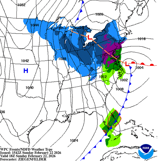
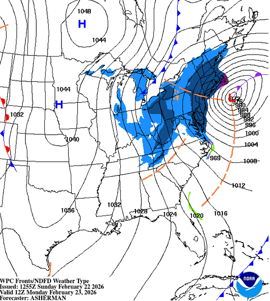
      A Major Nor’easter is set to undergo rapid intensification—or “bombogenesis”—off the Mid-Atlantic coast, creating a high-impact blizzard for the Northeast corridor.


      READ IN APP


      Storm Timeline and Intensity

      • Sunday Morning: Light to moderate snow begins across the Mid-Atlantic.
      • Sunday Evening – Monday Morning: The storm reaches peak intensity. Snowfall rates are expected to eclipse 2–3 inches per hour.
      • Monday Afternoon: Conditions are projected to improve as the system exits the region.


      Key Impacts

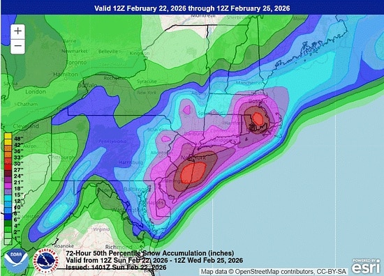
      • I-95 Corridor (Baltimore to Boston): Expect impossible travel conditions due to whiteouts and heavy snow. Some local areas along the NJ Coast could see over 2 feet of snow!
      • New York City & Long Island: For the first time since 2017, a Blizzard Warning has been issued for NYC, with 12–18 inches of snow forecast.
      • Boston & Southeast New England: Total accumulations could reach 1–2 feet with locally higher amounts, accompanied by wind gusts of 40–70 mph.
      • Mid-Atlantic (Delaware & Maryland): Significant snowfall and high winds are expected, particularly on the Eastern Shore.


        In addition to Blizzard conditions, the combination of heavy, wet snow and high winds is likely to down trees and power lines. Moderate to major flooding is also a concern during high tide for coastal communities from New Jersey to Massachusetts.

      Offshore

      Storm to Hurricane-Force winds are expected within 240 nm of the center with seas building 10-13 meters (33-43 feet) over the next 24-48 hours.

      NOAA High Seas Forecast

      NOAA Offshore Forecasts

      NOAA US Coastal Waters Forecasts

      NOAA Weather Prediction Center


      Ocean Weather Services

      Forensic Marine Weather Expert


      You’re currently a free subscriber to Fred Pickhardt’s Substack. For the full experience, upgrade your subscription.

      Upgrade to paid

       
      Like
       
      Comment
       
      Restack


      © 2026 Fred Pickhardt
      548 Market Street PMB 72296, San Francisco, CA 94104
      Unsubscribe

      Get the app Start writing

      Be the first to comment!


    Social Media Auto Publish Powered By : XYZScripts.com