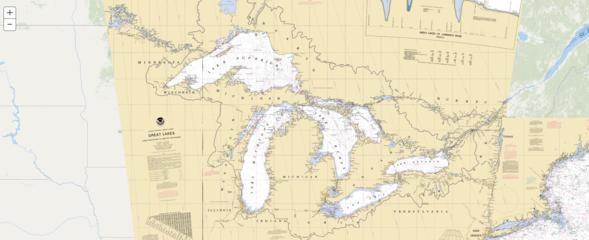
NOAA Custom Chart version 1.0 released to the public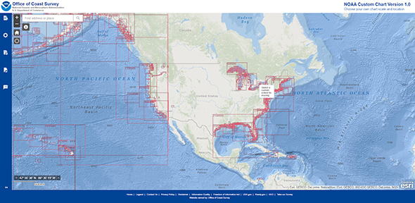 On April 1, 2021, NOAA’s Office of Coast Survey released NOAA Custom Chart version 1.0, a dynamic map tool which enables users to create their own paper and PDF nautical charts derived from the official NOAA electronic navigational chart (NOAA ENC®), NOAA’s premier nautical chart product. On April 1, 2021, NOAA’s Office of Coast Survey released NOAA Custom Chart version 1.0, a dynamic map tool which enables users to create their own paper and PDF nautical charts derived from the official NOAA electronic navigational chart (NOAA ENC®), NOAA’s premier nautical chart product.
Read more Sea level trends continue to increase at Atlantic and Gulf water level stations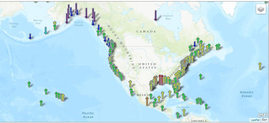
The map above illustrates relative sea level trends, with arrows representing the direction and magnitude of change. NOAA calculated new trends for its long-term water level stations, incorporating all NOAA water level data up to the end of 2020. The data shows that most long-term trends along the U.S. coastlines point to long-term and persistent sea level rise. Specifically, all U.S. Atlantic and Gulf of Mexico coastal stations experienced an uptick in their sea level trends in 2020. However, many stations along the Pacific coast experienced a slight reduction in their sea level trends. These trends span over 100 stations along the Atlantic, Gulf, and Pacific coasts and islands within the Caribbean Sea and Pacific Ocean. NOAA’s Precision Marine Navigation data service receives first major update The Precision Marine Navigation (PMN) program has completed the first update of its prototype navigation data service – the PMN data processing and dissemination system and PMN Data Gateway viewer. The data processing and dissemination system provides surface current forecast guidance from NOAA’s forecast systems, in a prototype marine navigation data format. The viewer allows users to visualize the predictions and discover where they are. Both the system and the viewer were updated to include data from the recently upgraded Northern Gulf of Mexico Operational Forecast System (NGOFS2). The Precision Marine Navigation (PMN) program has completed the first update of its prototype navigation data service – the PMN data processing and dissemination system and PMN Data Gateway viewer. The data processing and dissemination system provides surface current forecast guidance from NOAA’s forecast systems, in a prototype marine navigation data format. The viewer allows users to visualize the predictions and discover where they are. Both the system and the viewer were updated to include data from the recently upgraded Northern Gulf of Mexico Operational Forecast System (NGOFS2).
Read more NOAA and its partners to host outreach webinar on upcoming vertical datum updates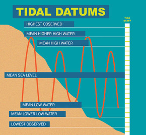 NOAA and its partner agencies in Canada are updating three vertical datums: the International Great Lakes Datum (IGLD) used to reference water levels in the Great Lakes and connecting channels; the National Tidal Datum Epoch (NTDE) used to reference water levels along the U.S. ocean coastline; and the North American Vertical Datum of 1988 (NAVD 88), the geodetic vertical datum that will be replaced by the North American-Pacific Geopotential Datum of 2022 (NAPGD2022). The datum updates are expected to impact a range of communities, including: navigation and shipping, permitting and planning, surveying and mapping, and water management. To learn more, join us on July 15 from 2:00 – 3:00 p.m. (EDT) for a joint webinar, Vertical Datums: An Overview and Planned Updates. NOAA and its partner agencies in Canada are updating three vertical datums: the International Great Lakes Datum (IGLD) used to reference water levels in the Great Lakes and connecting channels; the National Tidal Datum Epoch (NTDE) used to reference water levels along the U.S. ocean coastline; and the North American Vertical Datum of 1988 (NAVD 88), the geodetic vertical datum that will be replaced by the North American-Pacific Geopotential Datum of 2022 (NAPGD2022). The datum updates are expected to impact a range of communities, including: navigation and shipping, permitting and planning, surveying and mapping, and water management. To learn more, join us on July 15 from 2:00 – 3:00 p.m. (EDT) for a joint webinar, Vertical Datums: An Overview and Planned Updates. Register here |
 NOAA will shut down its Raster Navigational Chart (RNC) Tile Service and the online RNC Viewer on October 1, 2021. The NOAA Seamless Raster Navigational Chart Services will be shut down on January 1, 2022. This is part of a larger NOAA program to end production and maintenance of all NOAA traditional paper and raster nautical charts that was announced in the Federal Register in November 2019. NOAA will shut down its Raster Navigational Chart (RNC) Tile Service and the online RNC Viewer on October 1, 2021. The NOAA Seamless Raster Navigational Chart Services will be shut down on January 1, 2022. This is part of a larger NOAA program to end production and maintenance of all NOAA traditional paper and raster nautical charts that was announced in the Federal Register in November 2019.
Read more NOAA works with partners to expand several Physical Oceanographic Real-Time Systems, enhancing safety of marine navigationNOAA has worked with its local partners on the Gulf Coast, Mid-Atlantic and Southeast to expand its Physical Oceanographic Real-Time Systems PORTSⓇ to include important sensors that will improve marine navigation safety in these areas. The Corpus Christi PORTS upgrade includes several additional visibility meteorological stations, an offshore wave sensor, and current meters that will provide real-time information mariners can use to navigate the increasingly busy and congested seaport. The Sabine Neches PORTS added a current meter at an LNG facility in Sabine Pass, making it the eighth operational current meter in this PORTS. The Chesapeake Bay South PORTS also added a current meter, for a total of seven around the lower end of the Bay. Finally, a newly rebuilt water level and meteorological station was added to Jacksonville PORTS for monitoring along the St. Johns River, near the Buckman Bridge. The addition of these valuable real-time data helps mariners – particularly from large cargo ships and assisting tug boats coming in and out of port – to navigate safely, protecting life and property and keeping commerce moving smoothly. The Interagency Working Group on Ocean and Coastal Mapping announces progress report on mapping U.S. ocean, coastal, and Great Lakes waters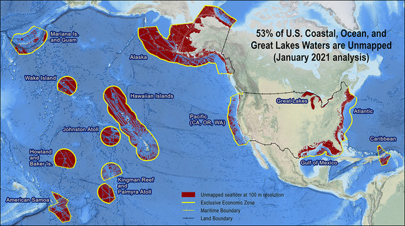 The Interagency Working Group on Ocean and Coastal Mapping (IWG-OCM) released the second annual report on the progress made in mapping U.S. ocean, coastal, and Great Lakes waters. The depth, shape, and composition of the seafloor are foundational data elements that we need to understand in order to explore, sustainably develop, conserve, and manage our coastal and offshore ocean resources. The 2020 National Strategy for Mapping, Exploring, and Characterizing the United States Exclusive Economic Zone and the global Seabed 2030 initiative make comprehensive ocean mapping a priority for the coming decade. The Unmapped U.S. Waters report tracks progress toward these important goals. The Interagency Working Group on Ocean and Coastal Mapping (IWG-OCM) released the second annual report on the progress made in mapping U.S. ocean, coastal, and Great Lakes waters. The depth, shape, and composition of the seafloor are foundational data elements that we need to understand in order to explore, sustainably develop, conserve, and manage our coastal and offshore ocean resources. The 2020 National Strategy for Mapping, Exploring, and Characterizing the United States Exclusive Economic Zone and the global Seabed 2030 initiative make comprehensive ocean mapping a priority for the coming decade. The Unmapped U.S. Waters report tracks progress toward these important goals.
Read more New coastal models will aid mariner safety on the west coast and Gulf of Mexico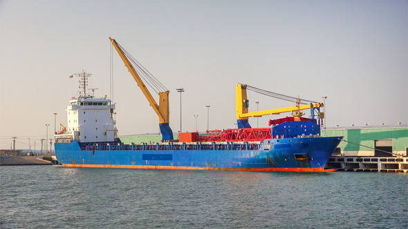
NOAA operational forecast models can help ships like this one docked in Corpus Christi anticipate coastal conditions that may impact the safety and efficiency of their travel routes. NOAA has launched two new models along the west coast and northern Gulf of Mexico that will provide continuous quality-controlled data on water levels, currents, water temperature and salinity out to 72 hours. These models will cover the entire west coast from Baja Mexico to British Columbia and the entire northern Gulf including the mouth of the Mississippi River, Lake Pontchartrain, and the Texas border. NOAA’s network of operational forecast models are being implemented in critical ports, harbors, estuaries, Great Lakes, and coastal waters of the U.S. to form a national backbone of real-time data, tidal predictions, data management and operational modeling. This network promotes safe marine navigation in the Nation’s waterways. Read more | 


Be the first to comment!