As much as we might wish to participate, we can’t always put on our gloves and boots and wade into the fray. So here is your opportunity to contribute to the efforts of this fine volunteer group to clean up Charleston’s waterways on our behalf. Please give what you can!
Wounded Nature – Working Veterans needs your help! We clean and rehabilitate critical coastal areas that others cannot reach: Trash/Debris, Treated Wood/Tires, Abandoned/Derelict Vessels.
We make a Real Coastal Difference but doing this requires the right equipment. 2021 is our year to grow and upgrade our 20+ year old boats with two proper workboats. With the right equipment, we will increase our capacity and reach to do more by going after the really tough to get stuff – big treated wood (dock pilings/telephone poles), buried tires, and all the stuff we’ve been seeing but unable to remove to date.
Sharing this fundraiser with your network is just as impactful so please SHARE away to help Wounded Nature – Working Veterans continue to MAKE A REAL COASTAL DIFFERENCE in 2021 and for years to come!
Once again, Greg Allard has blessed us with his descriptive narrative and beautiful photography as he and wife Barbara crossed Lake Okeechobee on April 27th. For more of Greg’s work, type Allard Letters in the Search Window of our Homepage. Thank you so very much Greg and Barbara!
We crossed the Okeechobee Waterway from east to west, departing on April 27, 2021. The Route 1 Lake Level was at 14.07’ which means that the Navigation Route 1 level (directly across the lake) was just over 8’. Our boat has a 5’ draft. The depth report from the Corp of Engineers was accurate, as we never had less than 3′ under the keel.
Currently (as of the report on May 5, 2021) the level is at 13.88’, or 7.82’ for Nav Route 1.
We used the Aqua Maps charts with the US Army Corp of Engineers depth shadings. The shallowest part of the crossing is generally in the Clewiston cut, in the SW corner of the lake. If you carefully adhere to channels, and do not stray or drift out of them, you will maintain the reported depths under your boat. Don’t let the wind push you sideways between the aids to navigation – the outside edges of the Clewiston channel are unforgiving rock. The lake level can change, so be sure to check the current depths on the Corp of Engineers site before your crossing: https://w3.saj.usace.army.mil/h2o/currentLL.shtml
We saw minimal evidence of algae: in the St. Lucie section, there was only one area with very small patches of green algae along one short stretch along the edge of the canal, on the south side.
In the Port Myacca lock (which was a mere 6” lift into the lake), there was light green line at the upper edge of the 6” water mark, along the north lock wall, but no evidence of algae in the lock. We saw no other algae on the entire Okeechobee Waterway. One boater did report that his sea chest had some showing of green color but it had not affected anything.
RIVER HOUSE MARINA: In 2021 we have stayed twice at the newly refurbished docks in Moore Haven at the River House, which is immediately west of the Moore Haven city dock. The location is a perfect layover stop for cruising boats – almost equidistant from the west and east coasts. For years we had stayed at the city docks ($1 a foot, with electric and water). But the River House now offers so much more, for the same price: $1 a foot includes free WiFi, (which is decent, but the owner intends to improve it), 30A & 50A electric and water, a swimming pool, bathrooms and showers, security gates onto the docks, and most importantly, they accept reservations through Dockwa. This is a huge benefit: if you have used the Okeechobee Waterway and wondered if you would find a place at the city docks when you arrived there in the afternoon, having a reservation at River House eliminates that concern.
The docks at River House have been completely refurbished. There are two fixed docks. The easterly dock is good for 40’+ boats, with drafts about 5’ or so; the westerly dock is for larger boats, and will hold three 60’ boats. The water depth there is 10’ plus. One small concern is that the new pilings on the westerly dock are low, so if your boat has a flared bow, you need to be certain that your stern is first brought against the well-cushioned pilings, to prevent the bow from going up against the tops of the pilings. The attentive owner of River House, Bob Holden, understands this issue, and is always on-hand to assist in docking. Again, you can make reservations through Dockwa, or call Bob Holden directly at 863-946-0466 to discuss your needs.
We have used the Okeechobee Waterway dozens of time, and it never disappoints us. It is always interesting – a step back in time to old Florida. Don’t worry about the locks; once you learn the basics of using them it becomes routine. Just tell the lockmaster if this is your first trip – they are very helpful. The Waterway also allows you to travel in conditions which would be prohibitive in the Gulf or through the Keys, and it saves time and fuel.
Some highlights of this trip:
A fiery sunrise on the Caloosahatchee portion of the Waterway.
After an early morning lock-through at Moore Haven. (photo by Ellen Pope).
Often there are cows, and sometimes horses, by water’s edge.
A small alligator “blocks” our exit from a lock. Manatees often go through the locks. One dockmaster told us that manatees hated the sound of a bow thruster, so giving it a short burst or two is a good way to safely move them along, out our your path. It works.
The affable bridge keeper at Fort Denaud. The day before this picture was taken, she had a lot of fun, when someone drove through the road gate, which was in the down position. The gate crashed through his windshield. The driver was not injured. He didn’t speak any English, so the dockmaster managed to have him call a friend who could translate. The translator said that the driver was texting. The bridge was closed for several hours.
The Okeechobee Waterway is always full of surprises. Along the western stretch, on April 29, 2021, we came upon this American bald eagle, peering down into the water.
He immediately threw himself into the river, and came out with a rather large fish, which is in his talons (not visible in the photo). He then flew off, with the fish in tow, to eat somewhere in peace. Some people have told us they would never use the Okeechobee Waterway; they are missing a lot.
Greg Allard M/V Meander Text and Photos copyright by Greg Allard, 2021
Bahamas Chatter is published by Explorer Chartbooks, A CRUISERS NET PARTNER, which has long been the standard navigational supplement for enjoyable, informative, and safe cruising through the beautiful Bahamian waters and island visits.
The Coast Guard rescued seven adults after their 25-foot vessel became aground at the South Jetty of the Savannah River, Friday. Owner intoxicated and only three life jackets for seven passengers.
Following passage of new regulations in Georgia for anchoring in the coastal waters of the state (House Bill 833 Effective July 1, 2020), Ted Arisaka, an experienced skipper and frequent contributor to Cruisers Net who has been active in the debates and issues surrounding boater access to public waters, posted this summation. Thank you Ted.
Anchoring in Georgia 2021
By Ted Arisaka
“Anchoring Permits” are only required if you plan to anchor in one place for more than 14 days in a year. “One place” is defined by a circle of 1 mile radius.
“Anchoring Restriction Areas” are a separate concept – you may not anchor in these areas overnight:
– Within 300 ft. of a marina
– Within 150 ft. of a marine structure (such as a private dock)
Marina setbacks are shown in red. Structures setbacks are shown in purple. Shellfish setbacks are shown in brown.
They are not charted by NOAA (I have requested this) nor are there currently ATONs in situ to delineate these areas. If you are on FB, we have a group there dedicated to GA Anchoring and one member took GA DNR’s KMZ files and converted them to GPX which you can import into AquaMap. Here is the post:
Also in this group, I took Bob Sherer’s (Bob423) long track through the state and overlaid the anchor restriction zones for shellfish harvest so one could get a sense for where they are in relation to the AICW:
As far as enforcement goes, I have only heard of one case where an anchored cruiser was asked to move in Turner Creek by GA Department of Natural Resources (DNR). The law enforcement officer was courteous but was mistaken on the particular setback being cited and some of us contacted GA DNR to alert them to the need for additional training. Technically it is a misdemeanor, so potentially $1000 fine and one year in jail.
GA DNR is telling us that this is “complaint driven” and they do not have the manpower or intention to patrol the coastal waters looking for violations.
There is another issue brewing due to Georgia’s handling of subtidal shellfish leases. Note that when the new anchoring regulations were enacted last year that a 500 foot setback was agreed to by all parties at the time, not knowing how the state was going to pursue the management of shellfish areas. The new leases will impact where vessels may anchor. Defining those areas and determining what the state’s intentions are is an ongoing struggle.
So at the end of the day, I personally would anchor in Georgia, in my usual spots, keeping away from docks and feel that I would be fine. At least for this spring and summer.
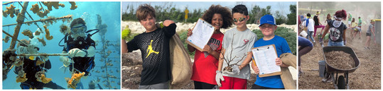
You are encouraged to read and participate in as many or all of the four NOAA Planet Stewards opportunities noted below. You’ll be glad you did.
Greeting NOAA Planet Stewards Educators!
Like me you probably don’t read each and every email that makes it to your inbox right away. You read and respond to the most time sensitive messages, but others you might leave to the end of the day – say The Watch newsletter? Sometimes a few emails – that you deem not essential to your work or personal life – might fall through the cracks and never get read. It happens to all of us. No judgement. That’s why I’m sending you this special announcement. I encourage you to read and participate in as many or all of the four NOAA Planet Stewards opportunities noted below. You’ll be glad you did.
Bruce Moravchik.
Coordinator, NOAA Planet Stewards
NOAA Planet Stewards is Now Accepting Proposals for Funding During the 2021-2022 Academic Year!
Are you an educator looking to initiate action in your school or community to address pressing environmental issues? Would $5,000 help you to realize your goals?
NOAA Planet Stewards is NOW accepting proposals from formal and informal educators working with elementary through university aged students to support projects – up to $5000 – to implement stewardship action projects that make a measurable impact in their school and/or community. Projects must focus on one of the following areas: marine debris, habitat conservation and restoration, carbon footprint reduction, or carbon sequestration.
To find out about eligibility, available resources, and the application process, go to our Planning a Project and Applying for Funding webpage, watch a recording of our recent broadcast and get started today!
Educators who have received funding from Planet Stewards in the past are eligible to apply!
This will be our last book club meeting of the 2020-2021 academic year, but we’ll be posting the selections for and the dates of next years book club to our Upcoming Events Webpage in just a few weeks!
The discussion is open to all.
To join us, dial 866-662-7513 (toll free)
Then, use the pass code: 1170791#
Share this invitation with all interested colleagues and networks
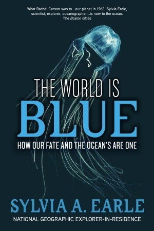
A Silent Spring for our era, this eloquent, urgent, fascinating book reveals how just 50 years of swift and dangerous oceanic change threatens the very existence of life on Earth. Marine scientist Sylvia Earle portrays a planet teetering on the brink of irreversible environmental crisis.
In recent decades we’ve learned more about the ocean than in all previous human history combined. But, even as our knowledge has exploded, so too has our power to upset the delicate balance of this complex organism.
Fortunately, there is reason for hope, but what we do—or fail to do—in the next ten years may well resonate for the next ten thousand. The ultimate goal, Earle argues passionately and persuasively, is to find responsible, renewable strategies that safeguard the natural systems that sustain us. The first step is to understand and act upon the wise message of this accessible, insightful, and compelling book.
Join NOAA Planet Stewards at one of our two educator professional development workshops this summer! Scroll down to find out more.
Community Resilience to Climate Change:
A Virtual Workshop for All Educators
Join us July 5-29, 2021 from anywhere you can Zoom. Formal educators will receive 24 CPE Credit hours. Educators of all subjects are welcome. Give students a voice to empower them, ignite change, and take action!
Workshop topics include: How to address climate change controversy; climate change impacts to human health; environmental justice; sustainability in Gulf fisheries; how coastal Texas ecosystems mitigate climate change; and more!
Live panel discussions with scientists from NOAA, Environmental Defense Fund, Green Building Resource Center, and more.
70% independent learning with access to a message board to communicate with scientists and your fellow educators.
Weekly hands-on activities.
Receive free tools and resources for your classroom.
Educators in the Galveston Texas area can participate in a 4 hour Kayak Adventure with a local scientist and artist (All Covid-safe protocols to be followed, lunch and snacks are provided!)
When: July 5-29, 2021 Online at your own pace. Live panel discussions from 9:00 – 11:00 am Central Time on July 8th, 15th, 22nd, and 29th.
Cost: Only $20 gets you: 24 CPE credits, vetted educational resources, all presentation videos and slides, 4 hour Kayak Adventure (for attendees in Galveston Texas Area) with coffee, lunch, and snacks – SUCH A DEAL!!!!!!
NOAA Planet Stewards and the Detroit Zoological Society are hosting a three-day workshop for educators to explore how global climate change is affecting the metro Detroit region, and how they can engage their students in taking action to address this global phenomena.
Thursday, August 19, 9 a.m. to 5 p.m. at the Detroit Zoo.
This workshop is planned for in-person learning. Depending on Covid-19 safety guidelines at the time of the workshop, an alternate, a virtual experience may be required. All registrants will be kept apprised of programmatic changes.
Workshop topics include:
How to incorporate weather and climate change activities that meet MI state curriculum requirements into existing curriculum; using citizen science projects to connect youth with their local environment; mobilizing youth to take action in their communities.
Workshop features:
Opportunities to learn from and interact with subject matter experts.
Hands-on learning experiences at the Detroit Zoo and Belle Isle Nature Center.
Light continental breakfast, lunch, and snacks are included each day of the workshop. Beverages and appetizers will be provided at the August 19 evening event.
Standards aligned classroom resources and materials.
Detroit educators will receive a fully paid opportunity (including transportation!) to bring their students to the Detroit Zoo or Belle Isle Nature Center for a learning experience.
When/Where:
Tuesday, August 17, 9 a.m. to 7 p.m. at the Detroit Zoo. Wednesday, August 18, 9 a.m. to 5 p.m. at the Belle Isle Nature Center. Thursday, August 19, 9 a.m. to 5 p.m. at the Detroit Zoo..
Who: Teachers in the Detroit area who work with upper elementary, middle or high school students.
Cost: $50 gets you: 14 SCHECHs (State Continuing Education Clock Hours); educational resources, tools, and materials for the classroom; a special evening event in the Polk Penguin Conservation Center; Light continental breakfast, lunch, snacks; and a fully paid for field trip for each classroom to visit the Zoo or Nature Center during the school year (the last item alone is a $400 value!)
While compiled by a group of Northeast “old salts” these videos are equally as applicable to our southern waters. Thank you for sharing, Off Center Harbor.
Hi Larry ~
It’s easy to feel like a fool sometimes while at the helm of a boat, or while trying to fix it.
There’s so much to learn, and it’s hard to develop new skills from reading a book or a magazine.
But with the power of video and the following two secrets, you can get one-on-one instruction from pros at the top of their field, and your learning curve can shoot straight up.
Even though top-notch instruction can quickly enhance your skills, there’s something that’s even more helpful in becoming a much better boater…
Secret #2: Heart-Felt Inspiration!
Good instruction is valuable, but getting inspired is priceless.
We get so many comments under our videos saying how much boaters have been inspired that we’ve given it a name — we call it the “inspiration curve”.
It’s different than your “learning curve”, but directly related, because a good “inspiration curve” can cause your learning curve to grow steeper and move faster.
Here is a video that provides a steep “inspiration curve”:
GETTING FULL ACCESSIn a few days, we’ll be sending you a great Mother’s Day/Father’s Day special to become a member with a 30% discount on your first year, plus a complimentary member’s hat.
If these videos have inspired you, we hope you’ll consider joining thousands of others from more than 80 countries as a member of Off Center Harbor.
Warmest regards, Steve, Ben, Bill, Eric and Maynard, Co-founders
Off Center Harbor
We’re proud to run Off Center Harbor the old fashioned way, relying on trust and authenticity among our customers, our crew, and our community.


Be the first to comment!