Mysterious Disease Killing Corals
Biologists race to learn what it is and maybe how to thwart it.

Mystery disease is killing Caribbean corals
ScienceNews for Students
Biologists race to learn what it is and maybe how to thwart it.
Mystery disease is killing Caribbean corals
ScienceNews for Students
In the ocean off southwest England, cold-water kelp is being replaced by a warm-water species, with profound effects for the local ecosystem.
The Surprising Consequences of a Seaweed Switcheroo
Hakai Magazine by Rebecca Dzombak
Our long history of constraining the river through levees has led to massive land loss in its delta. Can we engineer our way out? And at what cost?
The Controversial Plan to Unleash the Mississippi by Boyce Upholt
Hakai Magazine
The Friends of John Pennekamp Coral Reef State Park and Dagny Johnson Key Largo Hammock Botanical State Park are taking this famous sentiment one step further – by installing a state-of-the-art coral camera to showcase what lives in our waters.
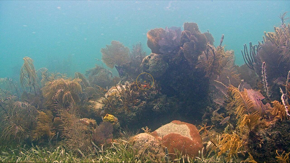
The Coral Cam presents a beautiful undersea vista. CONTRIBUTED
NEW PENNEKAMP STATE PARK CORAL CAM GIVES A VIEW INTO THE BLUE – Florida
Keys Weekly
Click Here To View the Cruisers Net Florida Keys Marina Directory Listing For John Pennekamp Marina
Click Here To Open A Chart View Window, Zoomed To the Location of Largo Sound

There is always plenty to do around Charlotte Harbor, especially at the Sunset Beach Club! While berthed at Fishermen’s Village Marina, A CRUISERS NET SPONSOR, you are certain to enjoy visiting Western Florida’s beautiful Charlotte Harbor/Peace River.
Click link for a calendar of events for Sunset Beach Club August 2022

| Kathy Burnam 941.639.8721
|
Click Here To View the Western Florida Cruisers Net Marina Directory Listing For Fishermen’s Village
Click Here To Open A Chart View Window, Zoomed To the Location of Fishermen’s Village
A new exhibit at the Graveyard of the Atlantic Museum reminds us that a vicious German U-boat campaign in the early months of World War II had once raged offshore the barrier islands, setting the sea ablaze and filling the air with explosions.

A simulated view through a submarine’s periscope is included in the new exhibit at the Graveyard of the Atlantic Museum. Photo: Catherine Kozak
U-boat artifacts, divers reveal history of Torpedo Junction by Catherine Kozak
CoastalReview.org
The Dare County Boat Builders Foundation is a non-profit, 501c3 organization dedicated to preserving Dare County’s boat building heritage by actively supporting the students and families within its community.

Click here for more on Dare County Youth Boat Builders Program
The increasing number of bridge closings due to increased rail traffic has been a concern for some time. See All Aboard Florida Protest by Jim Healy. The St Lucie FEC RR bridge with 6 ft vertical clearance crosses the Okeechobee Waterway and connects Britt Point with Stuart. See Concerned. The Loxahatchee RR bascule bridge crosses the AICW at MM 1005. See Replacement.
How Brightline work on Loxahatchee, St. Lucie railroad drawbridges will affect boaters – TC Palm
TC Palm
The nautilus’s lineage made it through all five of Earth’s previous mass extinctions. But can it survive the Anthropocene?

A tentacled fuzzy nautilus swims in the deep waters off the coast of Papua New Guinea. Though the nautilus is well known in some ways, it’s also mysterious; researchers studying it hope to get a handle on how it’s responding to impacts of the Anthropocene. Photo by Peter Ward
Ancient Nautilus, Uncertain Future
Hakai Magazine
Cruisers Net publishes Loose Cannon articles with Captain Swanson’s permission in hopes mariners with salt water in their veins will subscribe.. $5 a month or $42 for the year and you may cancel at anytime.

Florida To Launch ‘At Risk’ Vessel Turn-In Program
Peter Swanson


Be the first to comment!