Who is TopSide Marinas?

Topside Marinas, A CRUISERS NET SPONSOR, is a company invested in their team and customers creating lifelong memories, relaxing, enjoying life, and being healthy.

| |||||||||||||||||||||||||||||||||||
Topside Marinas, A CRUISERS NET SPONSOR, is a company invested in their team and customers creating lifelong memories, relaxing, enjoying life, and being healthy.
| |||||||||||||||||||||||||||||||||||
Scientists estimate that along the coast of Florida, where degradation is most severe, perhaps as little as 2% of original coral cover remains.
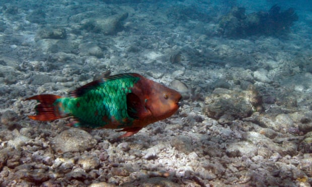
A parrotfish is swims over a dead coral reef in the Florida Keys national marine sanctuary near Key West, Florida. Photograph: Wilfredo Lee/AP
‘Dire outlook’: scientists say Florida reefs have lost nearly 98% of coral
The Guardian
Safety Harbor Marina is in the northwest corner of Old Tampa Bay, north of St. Petersburg and the Howard Franklin Bridge. Our thanks to Larry Pritchett for this alert.
Destroyed ATON G9 Safety Harbor Marina Channel
Day mark G9 in the Safety Harbor Marina Channel was destroyed by Storm ETA. Piling is below the water at high tide.
Iota is forecast to be at or near Category 5 hurricane strength when it makes a potentially catastrophic landfall along the coast of northeastern Nicaragua or eastern Honduras Monday night. As of noon Monday, Iota was moving west with winds of 160 mph!
Iota now ‘strongest hurricane of 2020 Atlantic season’ with 155 mph winds
SunSentinel
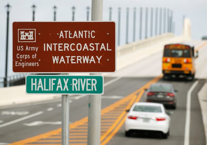
You could have corrected that…right?
Intra or Inter? New signs at Daytona bridge get a quick spelling correction
Daytona Beach News-Journal
Our thanks to Ted Arisaka for sharing this link from Georgia Public Broadcasting.
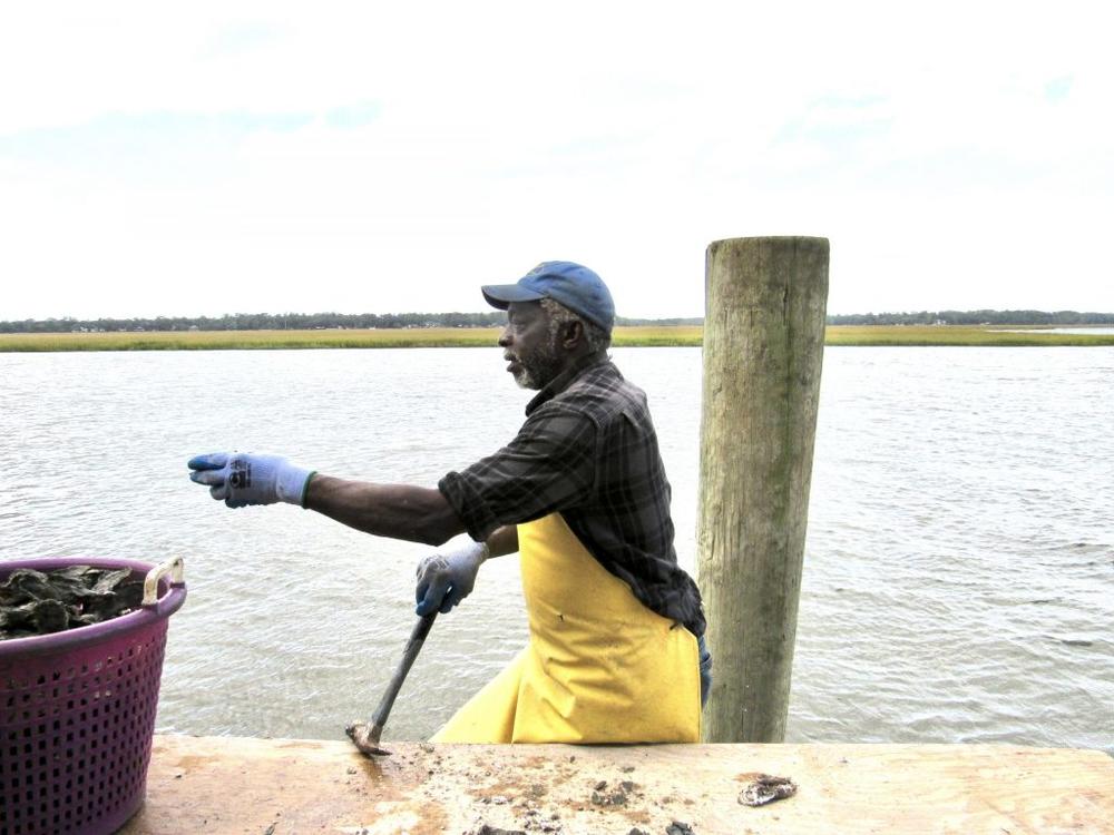
Will Georgia’s Fledgling Oyster Industry Sink Before It Swims?
GPB
Slate feeds marine creatures underwater, and the interaction enables divers to see large marine animals up close.


Bahamas Chatter is produced by Explorer Chartbooks, A CRUISERS NET PARTNER, which has long been the standard navigational supplement for enjoyable, informative, and safe cruising through the beautiful Bahamian waters and island visits.
Bahamas Chatter: Update COVID Exuma
Posted: 13 Nov 2020 06:46 AM PST
PRIME MINISTER STATEMENT ON EXUMA: INTRODUCED MEASURES TO REDUCE SPREAD OF COVID-19 IN EXUMA Prime Minister, Dr. Hubert Minnis announced the following restrictive measures for Exuma, effective Thursday, November 12:
1. There will be a 24-hour weekend curfew from 6pm Friday until 5am Mondays; businesses will not be allowed to operate during this time;
2. Weekday curfew will be from 6pm to 5am;
3. Commercial activity can continue through the week can continue save for fish frys, bars, and restaurants connected to bars;
4. Funerals are allowed at the graveside only and can have 10 people excluding the officiant; the same number of people is applicable to weddings – there will also be no repasts or receptions;
5. Church services are to be held virtually;6. Schools must be held virtually;
7. Effective tomorrow, domestic travel by air or sea is prohibited into and out of Exuma except in the case of emergency;
8. Anyone travelling from Exuma to any other island, must have a negative RT-PCR COVID-19 test;
9. No public or social gatherings are allowed.Dr. Minnis said these measures do not apply to the Exuma Cays.“I know this is short notice but this is essential after seeing what has happened on several past occasions,” he said.
The prime minister further explained that Exuma has recorded over 30 new cases in the past week.There are 79 positive cases from the island of Exuma – 28 are active, two are hospitalized and there has been one COVID-19 related death, according to Dr. Minnis. The prime minister also announced that the number of health care professionals on the island have been “boosted.”
“The measures on New Providence and Abaco have helped to decrease the spread of the virus on these islands,” the prime minister said earlier. “I assure you that we can continue to make progress if we continue to work together and wear our masks and avoid large gatherings.”He also said all positive cases are in isolation in Eleuthera and all contacts are being monitored.
The move to all digital tables and charts has been expected for some time.
NATIONAL OCEANIC ATMOSPHERIC ADMINISTRATION (NOAA) IS DISCONTINUING THE PRINTED TIDE TABLES AND TIDAL CURRENT TABLES
NOAA is ending the production of the printed Tide Tables and Tidal Current Tables publications. There will not be NOAA printed Tide Tables and Tidal Current Tables publications for 2021. NOAA is discontinuing the production of these annual publications due to: (a) recent changes by the U.S. Coast Guard in the interpretation of the
requirements for predictions, no longer requiring these publications in paper format and (b) the availability of online and electronic services providing tide and tidal current predictions which meet the U.S. Coast Guard requirements for navigation, and support other activities along the U.S. Coast.
Tide and Tidal Current predictions are available through NOAA’s Center for Operational Oceanographic Products and Services (CO-OPS) online services:
NOAA Tide Predictions: https://tidesandcurrents.noaa.gov/tide_predictions.html
NOAA Current Predictions: https://tidesandcurrents.noaa.gov/noaacurrents/Regions
For questions or more information, contact Tide.Predictions@noaa.gov or 301-713-2815 LNM 45/20
Silver Lake is Ocracoke Harbor and these two entrance markers are immediately south of the maintained channel into Silver Lake’s inlet.

| 1. THE FOLLOWING AIDS TO NAVIGATION HAVE BEEN RELOCATED.
A. SILVER LAKE JUNCTION LIGHT SL (LLNR 28985 [35°6.6266N / 075°59.5121W, 35.110443 / -75.991868]) RELOCATED TO APPROX POSIT 35-06-37.633N,
B. SILVER LAKE ENTRANCE DAYBEACON 2 (LLNR 28990 [35°6.4777N / 075°59.4183W, 35.107962 / -75.990305]) RELOCATED TO APPROX POSIT 35-06-28.552N, 075-59-25.205W. |


Be the first to comment!