Tavernier Diver’s Underwater World
Slate feeds marine creatures underwater, and the interaction enables divers to see large marine animals up close.

Slate feeds marine creatures underwater, and the interaction enables divers to see large marine animals up close.

Bahamas Chatter is produced by Explorer Chartbooks, A CRUISERS NET PARTNER, which has long been the standard navigational supplement for enjoyable, informative, and safe cruising through the beautiful Bahamian waters and island visits.
Bahamas Chatter: Update COVID Exuma
Posted: 13 Nov 2020 06:46 AM PST
PRIME MINISTER STATEMENT ON EXUMA: INTRODUCED MEASURES TO REDUCE SPREAD OF COVID-19 IN EXUMA Prime Minister, Dr. Hubert Minnis announced the following restrictive measures for Exuma, effective Thursday, November 12:
1. There will be a 24-hour weekend curfew from 6pm Friday until 5am Mondays; businesses will not be allowed to operate during this time;
2. Weekday curfew will be from 6pm to 5am;
3. Commercial activity can continue through the week can continue save for fish frys, bars, and restaurants connected to bars;
4. Funerals are allowed at the graveside only and can have 10 people excluding the officiant; the same number of people is applicable to weddings – there will also be no repasts or receptions;
5. Church services are to be held virtually;6. Schools must be held virtually;
7. Effective tomorrow, domestic travel by air or sea is prohibited into and out of Exuma except in the case of emergency;
8. Anyone travelling from Exuma to any other island, must have a negative RT-PCR COVID-19 test;
9. No public or social gatherings are allowed.Dr. Minnis said these measures do not apply to the Exuma Cays.“I know this is short notice but this is essential after seeing what has happened on several past occasions,” he said.
The prime minister further explained that Exuma has recorded over 30 new cases in the past week.There are 79 positive cases from the island of Exuma – 28 are active, two are hospitalized and there has been one COVID-19 related death, according to Dr. Minnis. The prime minister also announced that the number of health care professionals on the island have been “boosted.”
“The measures on New Providence and Abaco have helped to decrease the spread of the virus on these islands,” the prime minister said earlier. “I assure you that we can continue to make progress if we continue to work together and wear our masks and avoid large gatherings.”He also said all positive cases are in isolation in Eleuthera and all contacts are being monitored.
The move to all digital tables and charts has been expected for some time.
NATIONAL OCEANIC ATMOSPHERIC ADMINISTRATION (NOAA) IS DISCONTINUING THE PRINTED TIDE TABLES AND TIDAL CURRENT TABLES
NOAA is ending the production of the printed Tide Tables and Tidal Current Tables publications. There will not be NOAA printed Tide Tables and Tidal Current Tables publications for 2021. NOAA is discontinuing the production of these annual publications due to: (a) recent changes by the U.S. Coast Guard in the interpretation of the
requirements for predictions, no longer requiring these publications in paper format and (b) the availability of online and electronic services providing tide and tidal current predictions which meet the U.S. Coast Guard requirements for navigation, and support other activities along the U.S. Coast.
Tide and Tidal Current predictions are available through NOAA’s Center for Operational Oceanographic Products and Services (CO-OPS) online services:
NOAA Tide Predictions: https://tidesandcurrents.noaa.gov/tide_predictions.html
NOAA Current Predictions: https://tidesandcurrents.noaa.gov/noaacurrents/Regions
For questions or more information, contact Tide.Predictions@noaa.gov or 301-713-2815 LNM 45/20
Silver Lake is Ocracoke Harbor and these two entrance markers are immediately south of the maintained channel into Silver Lake’s inlet.

| 1. THE FOLLOWING AIDS TO NAVIGATION HAVE BEEN RELOCATED.
A. SILVER LAKE JUNCTION LIGHT SL (LLNR 28985 [35°6.6266N / 075°59.5121W, 35.110443 / -75.991868]) RELOCATED TO APPROX POSIT 35-06-37.633N,
B. SILVER LAKE ENTRANCE DAYBEACON 2 (LLNR 28990 [35°6.4777N / 075°59.4183W, 35.107962 / -75.990305]) RELOCATED TO APPROX POSIT 35-06-28.552N, 075-59-25.205W. |
My wife and I once spent a very pleasant three days in Elizabeth City waiting for the winds to drop allowing the long swing bridge to open. The 2.8-mile bridge across the Alligator River has closed several times in recent years to undergo repairs.
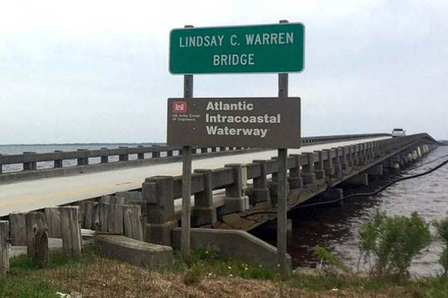
Lindsay C. Warren Bridge. Photo: Kill Devil Hills
Officials Push to Replace Alligator River Bridge
Coastal Review Online
Click Here To Open A Chart View Window, Zoomed To the Location of Alligator River Bridge
This excellent facility and CRUISERS NET SPONSOR, Southport Marina, was severely damaged by Isaias. See Hurricane Damage. As of November 6, they have resumed selling gasoline and diesel fuel.
We’re excited to announce that Southport Marina has resumed gasoline and diesel sales daily, from 8am-5pm. We are monitoring VHF ch. 16, phone 910-457-9900, and email info@southport-marina.com for any questions or needs. Although it will still be some time before we are able to accommodate overnight dockage for transiting guests, we would love to sell you the best quality marine fuel available while you’re in our town. Thank you for your patience while we continue to rebuild our facility! We’re looking forward to the opportunity to serve our customers again soon!
Hank Whitley, CMM
Marina Manager
Southport Marina
606 W. West St.
Southport, NC 28461
910-457-9900
View our live webcam at https://www.youtube.com/user/SouthportMarina
Click Here To View the North Carolina Cruisers Net Marina Directory Listing For Southport Marina
Click Here To Open A Chart View Window, Zoomed To the Location of Southport Marina
Our thanks to Phil and Karen for sharing their AGLCA Forum posting with our readers. Many of you will travel through Snows Cut at some point in your cruising lifetime. Mile long Snows Cut departs the coastal Waterway at the entrance to Carolina Beach and intersects Cape Fear River at Mile 296.
Living on the ICW, it’s amazing the number of boats we see every day heading south for the winter. 20, 30 a day perhaps, and we only see some of them. Trawlers, sailboats, large yachts and other craft, a few with looper flags but mostly snowbirds. Most loopers know Snow’s Cut, a few miles south of us, as a tricky waterway that connects the Cape Fear River with the ICW at Carolina Beach.
Though interesting, few good photos of this area exist. It’s difficult to get decent photos as you’re transiting it as you’re busy navigating a narrow, tricky channels with a 2 or 3 knot current. On a recent bike ride over the Snow’s Cut bridge, I took a few photos that might give our captains a good overview of the mile-long man-made cut.
Phil & Karen Barbalace
Helms Port
Wilmington,NC
Gold Loopers

Phil Kent and Karen Barbalace

Phil Kent and Karen Barbalace

Phil Kent and Karen Barbalace
Thanks for the great photos… Pictures are certainly worth a thousand words.
An important reminder for our North Carolina locals and for off-shore cruisers. Local knowledge is recommended for most for these inlets.
NC – HAZARDS OF NORTH CAROLINA COASTAL INLETS
Hazardous inlets. To heighten public awareness about the hazards that exist in and around the North Carolina coast, this information is provided to mariners. Shoaling conditions exist at following North Carolina coastal inlets:
Oregon Inlet
Hatteras Inlet
Ocracoke Inlet
Barden Inlet
Beaufort Inlet
Bogue Inlet
New River Inlet
Topsail Inlet
Masonboro Inlet
Carolina Beach Inlet
Lockwoods Folly Inlet
Shallotte Inlet
Shoaling conditions increase the potential for groundings. These inlets are subject to continual and sometimes rapid environmental changes. Mariners are highly encouraged to obtain the most recent U.S. Army Corps of Engineers Wilmington, North Carolina District hydrographic survey information, centerline waypoints and controlling depth at: http://www.saw.usace.army.mil/Missions/Navigation/HydrographicSurveys.aspx
Mariners should use caution when navigating in these areas and passage through the inlets is not recommended without local knowledge of the area. The aids to navigation in these inlets may not be charted and may not be marking best water due to continually shifting shoals. Consult Local Notice to Mariners, 5th Coast Guard District for the latest positions and status of aids to navigation:
https://www.navcen.uscg.gov/?pageName=lnmDistrict®ion=5
To report any aids to navigation discrepancies (missing, damaged, off station, extinguished lights), shoaling, hazards to navigation, or discrepancies on bridge lighting, please contact Sector North Carolina Command Center (910) 343-2200.
Ortona Lock is located at Okeechobee Waterway Statute Mile 94, just east of unlighted daybeacon #1 and flashing daybeacon #2. No estimated time of repair is given. Our thanks to Specialist Erica Skolte for this notice.
Notice to Navigation 2020-016: Okeechobee Waterway – Ortona Lock 25-foot width restriction
NOTICE TO NAVIGATION INTERESTS
Date: 11/04/2020
US ARMY CORPS OF ENGINEERS
JACKSONVILLE DISTRICT
ATTN: CESAJ-OD-SN
PO Box 4970
JACKSONVILLE, FL 32232-0019
863-983-8101
NOTICE NUMBER: 2020-016
WATERWAY: OKEECHOBEE WATERWAY
EFFECTIVE: 11/04/2020
POC: http://www.saj.usace.army.mil/Missions/CivilWorks/Navigation/NoticestoNavigation.aspx
OKEECHOBEE WATERWAY
ORTONA LOCK & DAM
REFERENCE:
a.33 CFR Navigation and Navigable Waters
1.Notice to Navigation
The Ortona Lock and Dam will have a width restriction of 25 feet until further notice. This restriction is due to mechanical failure. Crews are currently assessing the situation. No estimated time of repair currently available.
The South Florida Operations Office advises all vessels to monitor the Jacksonville District website for any changes or updates.
//SIGNED//
Gary L. Hipkins
Chief, Navigation
South Florida Operations Office
Thanks for getting the word out!
Be safe!
Erica
Erica Skolte
Public Affairs Specialist
Corporate Communications Office
U.S. Army Corps of Engineers, Jacksonville District Palm Beach Gardens
OFFICE PHONE 561-340-1527
Cell: 561-801-5734
Twitter @JaxStrong
Jacksonville District Facebook:
https://www.facebook.com/JacksonvilleDistrict
Jacksonville District: A team of professionals making tomorrow better “Keep Calm and Essayons”
Click Here To View the Okeechobee Cruisers’ Net Bridge Directory Listing For Ortona Lock
Click Here To Open A Chart View Window, Zoomed To the Location of Ortona Lock
News you can use from NOAA Planet Stewards.

The Watch. News You Can Use From NOAA Planet Stewards – 3 November 2020
National Ocean Service, NOAA


Be the first to comment!