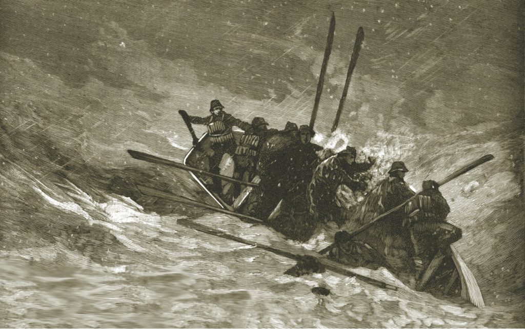
The second in a two-part series by author Kevin Duffus takes readers along with the Cape Fear lifesavers to save the crew from the wreckage of the Charles C. Dame on Frying Pan Shoals.
Author Kevin Duffus takes readers to the 1890s in this two-part series that looks at the U.S. Life-Saving Service and the daring rescues during dangerous storms by its crews on the North Carolina coast.
At the intersection of the Atlantic Intracoastal Waterway and the Okeechobee Waterway, Martin County, A CRUISERS NET SPONSOR, is a hub of boating activity and of events of interest to boaters.
How are you feeling about attending events in the coming months?
WE WANT TO HEAR FROM YOU!
How are you feeling about attending events in the coming months?
We’ve teamed up with several of Martin County’s most loved events and attractions to ask you to share your thoughts with us. It’s a short and simple 8 question survey, so please take a moment to tell us how you are feeling. Your candor and participation are greatly appreciated. Your response is requested before midnight on Sunday, September 28th. Stay well…and thank you in advance for participating.
Oyster lovers will tell you that Carolina oysters are extra special. It is great that these oyster beds in Pamlico Sound are being regrown. The North Carolina Coastal Federation is partnering with the state Division of Marine Fisheries to add 15 acres of new oyster reef habitat in Pamlico Sound.
The beautiful Oak Island area is also home to three CRUISERS NET SPONSORS: Southport Marina, Deep Point Marina and Bald Head Island Marina – three more reasons to visit Oak Island. See Annual Oak Island Lighthouse Run for a rescheduled fall event.
Back in the mid-19th century, and continuing until 1930, a group of whalers in Australia’s Twofold Bay worked with a pod of killer whales to catch and kill baleen whales.
All of these relocated buoys are in the shallow waters near Hatteras Inlet.
CCGD5 BNM 492-20 NC CAPE HATTERAS – HATTERAS INLET (CHART 11555) 1. THE FOLLOWING AID TO NAVIGATION HAS BEEN RELOCATED. A. BARNEY SLOUGH CHANNEL BUOY 3A (LLNR 28721.6 [35°13.4891N / 075°47.2234W, 35.224819 / -75.787057]) HAS BEEN RELOCATED TO APPROX. POSITION 35-13.391N 075-47-14.176W (35°13.3910N / 075°47.2363W, 35.223183 / -75.787271)
CCGD5 BNM 493-20 NC CAPE HATTERAS – HATTERAS INLET (CHART 11555) 1. THE FOLLOWING AID TO NAVIGATION HAS BEEN RELOCATED. A. HATTERAS INLET BUOY 12B (LLNR 28733.1 [35°12.2021N / 075°43.9067W, 35.203369 / -75.731778]) HAS BEEN RELOCATED TO APPROX. POSITION 35-12-11.824N, 075-43-55.492W (35°12.1970N / 075°43.9249W, 35.203284 / -75.732081)
CCGD5 BNM 491-20 NC CAPE HATTERAS – HATTERAS INLET (CHART 11555) 1. THE FOLLOWING AID TO NAVIGATION HAS BEEN RELOCATED. A. HATTERAS INLET CHANNEL LIGHT 19A (LLNR 28765 [35°12.2594N / 075°43.2737W, 35.204323 / -75.721228].1) HAS BEEN RELOCATED TO APPROX. POSITION 35-12-22.182N, 075-43-15.216W (35°12.3697N / 075°43.2536W, 35.206162 / -75.720893) . B. HATTERAS INLET CHANNEL LIGHTED BUOY 12A (LLNR 28732 [35°12.6338N / 075°43.9497W, 35.210563 / -75.732495].1) HAS BEEN RELOCATED TO APPROX. POSITION 35-12-19.060N, 075-43-54.971W (35°12.3176N / 075°43.9162W, 35.205294 / -75.731936) . C. HATTERAS INLET CHANNEL LIGHT 19 (LLNR 28765 [35°12.2594N / 075°43.2737W, 35.204323 / -75.721228]) HAS BEEN RELOCATED TO APPROX. POSITION 35-12-14.587N, 075-43-16.377W (35°12.2431N / 075°43.2730W, 35.204052 / -75.721216) . D. HATTERAS INLET CHANNEL LIGHTED BUOY 12 (LLNR 28732 [35°12.6338N / 075°43.9497W, 35.210563 / -75.732495]) HAS BEEN RELOCATED TO APPROX. POSITION 35-12-36.785N, 075-43-55.362W (35°12.6131N / 075°43.9227W, 35.210218 / -75.732045) .


Be the first to comment!