| September 27, 2021 | City of Gulfport, FL – Gateway to the Gulf Newsletter |
| |
| Upcoming Events See what’s happening this month. |
| City Manager Report Read the current community news. |
| Senior Center E-news Click here to see what’s happening next. |
| Library Calendar of Events Upcoming activities at the Gulfport Library. |
| Michael J. Yakes Recreation Center Click here to see all classes and activities. |
| | Get your family, organization or business in on the fun and sign-up NOW for the Veterans Day Parade ! |
|
|
| This Weeks Events & Meetings |
|
|
| | Gulfport Tuesday Fresh Market Tuesday, September 28th | 9 a.m. – 2 p.m. |
Join us weekly at our open-air fresh market for the region’s freshest produce, arts & crafts from local creators and a fresh array of locally sourced botanicals along the shops and restaurants of scenic Beach Boulevard. |
|
|
| | Ballroom Dance Lessons w/ Carol Baker Tuesday, September 28th | Noon – 3 p.m. |
| Gulfport Casino Ballroom 5500 Shore Blvd. S. $10 admission Call 727-798-3660 |
|
|
| | Argentine Tango Dance & Lesson w/ Kathleen & Steve Prucher Tuesday, September 28th | 6:30 p.m. – 11 p.m. |
| Gulfport Casino Ballroom 5500 Shore Blvd. S. $10 admission Call 727-742-3368 |
|
|
| | Virtual Neighborhood Watch Meeting Every Wednesday | 1:30 p.m. |
Broadcasting “on Facebook” Wednesdays at 1:30 p.m. Check on updates for your area and learn about recent incidents related to vehicle, residential burglaries, BOLO’s and stolen vehicles. For more information, please contact Mr. Jim Wright Volunteer Coordinator at 727-893-1022 or jwright@mygulfport.us. |
|
|
| | Swing Dance & Lesson w/ Swing Time Wednesday, September 29th Lesson 7 – 8 p.m. | Dancing 8 – 11 p.m. |
| Gulfport Casino Ballroom 5500 Shore Blvd. S. $10 admission |
|
|
| | First Friday Art Walk Friday, October 1st | 5 – 9 p.m. Downtown Waterfront District Beach Blvd. S. Come join us with free live music up and down the street. Follow the flags for artist clusters, displaying paintings, jewelry, glass, mixed media sculpture and more. First Friday Art Walk is a juried event that welcomes emerging and professional artists in all media to engage in our arts loving community. |
|
|
Special Guest: Larry Busby, Photographer A Gulfport Sound & Sight Experience II |
| | Theater Opening Art Reception & Exhibit Friday, October 1st | 6 – 8 p.m. Catherine Hickman Theater | 5501 27th Ave. S. Exhibit runs thru Oct. 28th | Mon. – Fri., 8 a.m. – 4 p.m. Everyone is invited to a free Opening Art Reception & Exhibit featuring the works of the Gulfport Arts Center. Come join us for live music with Gulfport’s own Berkeley Grimball & His Pod Harp Orchestra, featuring Stone Handy, Tony Treadway & Michael Beck. Tutto Bene Italian Bistro, a Gulfport favorite Italian restaurant, will have free pizza by the slice, and the city will operate a cash bar in the lobby. |
|
|
Lions Club of Gulfport 4630 Tifton Drive S. |
| | Gulfport Lions Club Pancake Breakfast Saturday, October 2nd | 8 – 11 a.m. Following all CDC guidelines, Lion’s members and volunteers will be serving all-you-can-eat pancakes, scrambled eggs, link sausage, coffee, tea and orange juice all for $9.00. Children under the age of 12 can eat for half price. Seating will be limited to 50% capacity. In addition to indoor seating, we will also have outdoor seating and to-go meals available. |
|
|
| Upcoming Events & Meetings |
|
|
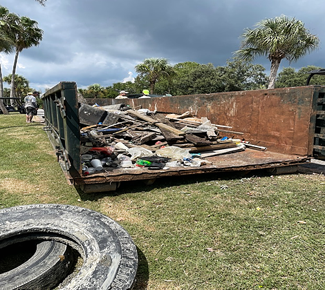
| | City of Gulfport Junk Drop Saturday, October 9th | 8 a.m. – 1 p.m. 49th Street Neighborhood Center 1617 49th St. S. We ask that residents please stay in your vehicle and that all items are placed in an easily accessible location; the backseat, trunk, truck bed, or trailer. For questions or more information, please contact 727-893-1089. |
|
|
| | Monday Night Hustle w/ Carol Baker Monday, October 11th & 18th | 6 – 10 p.m. Gulfport Casino Ballroom 5500 Shore Blvd. S. 7 p.m.: Beginner Class (4 count hustle) 8 p.m.: Intermediate Class (3 and 4 count hustle) 8 p.m. to 10 p.m.: Disco Dance Party $15 admission Call 727-798-3660 |
|
|
For more information, call the Gulfport Casino Ballroom at (727) 893-1070. |
| | Sock Hop with the Legendary Impacs Friday, October 15th | 7 – 10 p.m. Step back in time as you dance to the sounds of the 50s and 60s with the legendary Impacs. Tickets, in advance, are $15 each (before 4:30 p.m. 10/14/21) and available at the Gulfport Casino Box office, 5500 Shore Blvd S. or the Downtown Beach Bazaar at 3115 Beach Blvd. S. The fun begins the night of the show with doors opening at 6:30 p.m. and live music starting at 7 p.m. Admission at the door, the night of the show, is $20 per person. |
|
|
| | International Coastal Clean Up Saturday, October 16th | 9 a.m. – noon Clam Bayou Nature Park Miriam St. S. Join Gulfport Grassroots, Keep Pinellas Beautiful, and the City of Gulfport Florida to clean up our Clam Bayou Nature Preserve on land & water. Registration will be at Osgood Point by the Coast Guard Station at the end of Miriam Street South. |
|
|
| | Third Saturday Indie Faire Saturday, October 16th | 5 – 9 p.m. Downtown Waterfront District Beach Blvd. S. Welcome to Third Saturday Indie Faire! The Indie Faire features high quality local art and contemporary crafts from across a wide range of mediums, as well as jewelry and locally sourced botanicals in an outdoor and socially distanced manner along scenic Beach Boulevard in downtown Gulfport. |
|
|
| | Ask a City Councilor Event at the Third Tuesday Fresh Market Tuesday, October 19th | 11 a.m. – 1 p.m. |
| Gulfport Welcome Center, 3101 Beach Blvd. S. Gulfport City Council will be hosting an opportunity, every third Tuesday of the month, for residents to get to know their Councilmember, ask questions, and provide comment. For more information, please call City of Gulfport Vice Mayor, Ward 1 Representative, April Thanos at (727) 826-7138. |
|
|
| | Mobile Food Pantry Thursday, October 21st | 3 – 5 p.m. Recreation Center, 5730 Shore Blvd. S. FREE pre-packaged box of groceries while supplies last. For more information, please call 727-443-4031 ext. 506 or email info@hopevillagesofamerica.org. |
|
|
| | Fourth Saturday Fresh Market Saturday, October 23rd | 9 a.m. – 2 p.m. Gulfport Waterfront District Beach Blvd. S. Come see all of your favorite vendors from the Gulfport Tuesday Fresh Market and catch all the fresh faces this 4th Saturday! |
|
|
| | Gecko Ball Saturday, October 23rd | 6 – 11 p.m. Gulfport Casino Ballroom, 5500 Shore Blvd. S. The Gecko Ball is one of Gulfport’s most popular events, featuring music, dancing, a costume contest, silent and live auctions, the Gecko Queen coronation, and a cash bar. Guests are highly encouraged to dress in American Bandstand or Gecko themed costumes, or a combination of both! |
|
|
| | Gulfport Lions Club – Feeding Tampa Bay Mobile Food Program Thursday, October 28th | 4:30 – 6 p.m. Gulfport Lions Club 4630 Tifton Drive S. For additional updated assistance, text FTBFYI to 855-530-3663 or visit https://www.feedingtampabay.org. |
|
|
| | Trick or Treat Trail & Costume Contest Saturday, October 30th | 4 – 7 p.m. Gulfport Recreation Center (walking trail behind building) 5730 Shore Blvd. S. Masks are strongly encouraged. For more information, please contact 727-893-1068 |
|
|
| | ProSisters 20th Year Birthday Celebration Saturday, October 30th | 7 – 11 p.m. Gulfport Casino Ballroom 5500 Shore Blvd. S. Celebrate with us as we officially recognize the 20 year anniversary of ProSisters (formerly ProSuzy). |
|
|
Deadline for submission is 3 p.m. Friday, October 15 |
| | Gulfport’s Art in the Yard – Community Art Sale Saturday, November 6th | 10 a.m. – 4 p.m. It’s time to showcase original art created by you in Gulfport’s Art in the Yard Sale, Saturday, November 6 (rain date, Sunday, November 7). You can have your art sale at your Gulfport residence. For more information or to sign-up, please visit https://mygulfport.us/gulfport-art-in-the-yard/. |
|
|
| | 2021 Heroes Weekend Sunday, November 7th | 11 a.m. – Parade Downtown Waterfront District | Beach Blvd. | Gulfport Beach Whether you served in the military or serve on the volleyball court, join in the City of Gulfport and VetSports Heroes Weekend on Saturday & Sunday, November 6 – 7. It’s a great way for the community to participate in Veteran’s Day while giving back to local Veterans. To sign up to participate in the parade or for more information, please visit https://mygulfport.us/heroesweekend/. |
|
|
| | Gulfport Permit FREE City-Wide Yard Sale Saturday, November 20th | Dawn – Dusk City of Gulfport, FL, Residents Only It’s time to clear out the clutter and sign up for permit free City of Gulfport City-Wide Yard Sale. Do not miss this tremendous opportunity to have your Gulfport address on the brochure and google maps for added visibility. |
|
|
| ALERTPinellas Sign up for emergency notification services here. |
| Pinellas County Emergency Management Prepare yourself and your family here. |
| Latest Beach Water Quality Sampling Data See the latest report here. |
| Public Cameras Check out our live streaming cameras here, to see what you are missing. |
| Gulfport Charter & Code of Ordinances Online access is provided at the following link. |
| |
|
| The Gulfport Senior Center and Humana Present Active Aging Week A Week of Events Focused on the Seven Dimensions of Wellness: Physical, Social, Environmental, Financial, Spiritual, Emotional & Cognitive. ACTIVE AGING WEEK | OCTOBER 4TH – 8TH |
|
|
City of Gulfport Utilities Customer Service Department: utilitiesinfo@mygulfport.us 727-893-1016 2401 53rd Street South Gulfport, FL 33707 Mon. – Fri. 8 a.m. – 4:40 p.m. |
| Effective October 1, 2021, City of Gulfport utility customers will no longer be charged a $3.25 convenience fee when paying their utility bill with a Debit/Credit card online (We accept Visa, Mastercard, Discover and American Express) or in person (all debit/credit cards) at Gulfport City Hall. Customers paying by phone using a credit/debit card will still be charged a $3.25 convenience fee. The easy-to-use payment portal provides customers with quick access to their account to view bills, check their balance, make payments and enroll in paperless billing. Need help navigating the online utility bill payment system? Click on the Video below. |
|
|
| The New Horizons Band of Gulfport wants you! We will begin our fall session on Tuesday, October 5, 2021 at Chase Park, 5313 27th Avenue S, Gulfport, FL 33707. This session concludes in December with a holiday concert at the Catherine Hickman Theater. The charge for the session is $25 |
|
|
| The Gulfport Public Works Department located at the 49th Street Neighborhood Center (1617 49th St. S.) is an official collection site for rechargeable batteries! For more information, please call 727-893-1089 or visit https://mygulfport.us/public-works-department/. |
|
|
| Wood Ibis Park is a 4-acre park located along 58th St. S. at approximately 28th Ave. S. The most distinguishing feature of the park is the lake. With native aquatic plantings and a fountain to keep the water aerated, the park has become a favorite location for small bunnies, wading birds and a variety of ducks. |
|
|
| The City of Gulfport Senior Center’s Telephone Reassurance Program is a free service for Gulfport Residents 50 years of age or older. Volunteers provide daily phone calls to registered members and provide comfort, security, and peace of mind to members and families. Registration is simple and free. If you or someone you know could benefit from this service during this difficult time, please call (727) 893-2237 and register today. |
|
|
| GEMS door-to-door transportation has provided independence & freedom to elderly and disabled residents of Gulfport for over 40 years. Any Gulfport residents 55 & older or residents with a disability can take advantage of GEMS door to door service for a yearly membership of $70 plus $2 per ride. For more information, call 893-2242. |
|
|
| The Gulfport Public Library (5501 28th Ave. S.) is open with limited service. Check out all the virtual events they have to offer on their Facebook page at, www.facebook.com/GulfportLibraryFL. For more information, please call 727-893-1074. |
|
|
| The City App for iOS and Android mobile devices, allows residents to connect more conveniently with City government to report issues and request non-emergency services. For more information, please email info@mygulfport.us or call 727-893-1118. |
|
|
|
|
|


Be the first to comment!