Greeting NOAA Planet Stewards Educators! Like me you probably don’t read each and every email that makes it to your inbox right away. You read and respond to the most time sensitive messages, but others you might leave to the end of the day – say The Watch newsletter? Sometimes a few emails – that you deem not essential to your work or personal life – might fall through the cracks and never get read. It happens to all of us. No judgement. That’s why I’m sending you this special announcement. I encourage you to read and participate in as many or all of the four NOAA Planet Stewards opportunities noted below. You’ll be glad you did. Bruce Moravchik. Coordinator, NOAA Planet Stewards 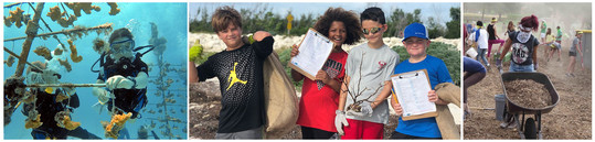
NOAA Planet Stewards is Now Accepting Proposals for Funding During the 2021-2022 Academic Year! Are you an educator looking to initiate action in your school or community to address pressing environmental issues? Would $5,000 help you to realize your goals? NOAA Planet Stewards is NOW accepting proposals from formal and informal educators working with elementary through university aged students to support projects – up to $5000 – to implement stewardship action projects that make a measurable impact in their school and/or community. Projects must focus on one of the following areas: marine debris, habitat conservation and restoration, carbon footprint reduction, or carbon sequestration. To find out about eligibility, available resources, and the application process, go to our Planning a Project and Applying for Funding webpage, watch a recording of our recent broadcast and get started today! Educators who have received funding from Planet Stewards in the past are eligible to apply! Join us at our next Book Club meeting:Monday May 17th, at 8:00 pm EDT.We’ll be discussing:by Sylvia EarleThis will be our last book club meeting of the 2020-2021 academic year, but we’ll be posting the selections for and the dates of next years book club to our Upcoming Events Webpage in just a few weeks! The discussion is open to all.To join us, dial 866-662-7513 (toll free) Then, use the pass code: 1170791#Share this invitation with all interested colleagues and networks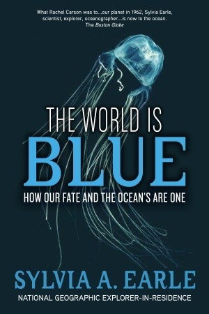 | | A Silent Spring for our era, this eloquent, urgent, fascinating book reveals how just 50 years of swift and dangerous oceanic change threatens the very existence of life on Earth. Marine scientist Sylvia Earle portrays a planet teetering on the brink of irreversible environmental crisis. In recent decades we’ve learned more about the ocean than in all previous human history combined. But, even as our knowledge has exploded, so too has our power to upset the delicate balance of this complex organism. Fortunately, there is reason for hope, but what we do—or fail to do—in the next ten years may well resonate for the next ten thousand. The ultimate goal, Earle argues passionately and persuasively, is to find responsible, renewable strategies that safeguard the natural systems that sustain us. The first step is to understand and act upon the wise message of this accessible, insightful, and compelling book. |
Join NOAA Planet Stewards at one of our two educator professional development workshops this summer! Scroll down to find out more. Community Resilience to Climate Change:A Virtual Workshop for All Educators
Join us July 5-29, 2021 from anywhere you can Zoom. Formal educators will receive 24 CPE Credit hours. Educators of all subjects are welcome. Give students a voice to empower them, ignite change, and take action! Workshop topics include: How to address climate change controversy; climate change impacts to human health; environmental justice; sustainability in Gulf fisheries; how coastal Texas ecosystems mitigate climate change; and more! - Live panel discussions with scientists from NOAA, Environmental Defense Fund, Green Building Resource Center, and more.
- 70% independent learning with access to a message board to communicate with scientists and your fellow educators.
- Weekly hands-on activities.
- Receive free tools and resources for your classroom.
- Educators in the Galveston Texas area can participate in a 4 hour Kayak Adventure with a local scientist and artist (All Covid-safe protocols to be followed, lunch and snacks are provided!)
When: July 5-29, 2021 Online at your own pace. Live panel discussions from 9:00 – 11:00 am Central Time on July 8th, 15th, 22nd, and 29th. Where: Anywhere you can Zoom! More Information & Register at: https://www.artistboat.org/noaa-professional-development/ Cost: Only $20 gets you: 24 CPE credits, vetted educational resources, all presentation videos and slides, 4 hour Kayak Adventure (for attendees in Galveston Texas Area) with coffee, lunch, and snacks – SUCH A DEAL!!!!!! Questions? Contact: Karissa Laffey (klaffey@artistboat.org) or call: 409-632-0388 Climate Justice: Exploring the Science ofClimate Change in Your Classroom
NOAA Planet Stewards and the Detroit Zoological Society are hosting a three-day workshop for educators to explore how global climate change is affecting the metro Detroit region, and how they can engage their students in taking action to address this global phenomena. Participants will attend: This workshop is planned for in-person learning. Depending on Covid-19 safety guidelines at the time of the workshop, an alternate, a virtual experience may be required. All registrants will be kept apprised of programmatic changes. Workshop topics include: How to incorporate weather and climate change activities that meet MI state curriculum requirements into existing curriculum; using citizen science projects to connect youth with their local environment; mobilizing youth to take action in their communities. Workshop features: - Opportunities to learn from and interact with subject matter experts.
- Hands-on learning experiences at the Detroit Zoo and Belle Isle Nature Center.
- Light continental breakfast, lunch, and snacks are included each day of the workshop. Beverages and appetizers will be provided at the August 19 evening event.
- Standards aligned classroom resources and materials.
- Detroit educators will receive a fully paid opportunity (including transportation!) to bring their students to the Detroit Zoo or Belle Isle Nature Center for a learning experience.
When/Where: Tuesday, August 17, 9 a.m. to 7 p.m. at the Detroit Zoo.
Wednesday, August 18, 9 a.m. to 5 p.m. at the Belle Isle Nature Center.
Thursday, August 19, 9 a.m. to 5 p.m. at the Detroit Zoo.. Who: Teachers in the Detroit area who work with upper elementary, middle or high school students. Cost: $50 gets you: 14 SCHECHs (State Continuing Education Clock Hours); educational resources, tools, and materials for the classroom; a special evening event in the Polk Penguin Conservation Center; Light continental breakfast, lunch, snacks; and a fully paid for field trip for each classroom to visit the Zoo or Nature Center during the school year (the last item alone is a $400 value!) Pre Register at: https://forms.gle/GNn3DC6wh5kuYfC6A Questions? Contact: Claire Lannoye-Hall or Erin Parker | 


Be the first to comment!