Sunrise over Riviera Dunes Marina by Coby Gaulien
Love these sunrise photos! Thank you Coby and thank you all!
Riviera Dunes Marina is A CRUISERS NET SPONSOR!

Love these sunrise photos! Thank you Coby and thank you all!
Riviera Dunes Marina is A CRUISERS NET SPONSOR!
The United States Coast Guard doing what they do best – even when off-duty! Well done Chief Matthew Hare!

Off-duty Coast Guardsman rescues boater from capsized vessel near Cumberland Island

JACKSONVILLE, Fla. — An off-duty Coast Guardsman rescued a boater from a capsized vessel Friday near Cumberland Island, Georgia.
The Coast Guardsman, Chief Matthew Hare of the cutter Hammer, notified Coast Guard Sector JacksonvilleCommand Center watchstanders he noticed one boater sitting on his capsized 16-foot boat at 7:30 p.m while on his personal boat. Hare retrieved the man from the water and transported him to Fernandina Harbor Marina.
“Even when we’re out of uniform, we as Coast Guardsman are always on duty,” said Hare. ” The maritime community is always there for each other.”
The boater was reported to be in good condition.
The owner of the vessel is coordinating salvage.
For more breaking news follow us on Twitter.
Bravo Zulu, Chief Hare! Always prepared.
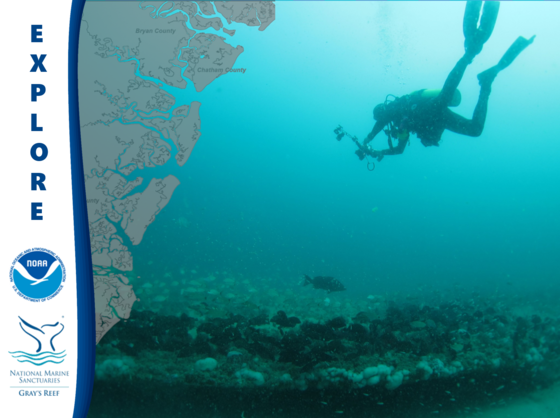
Gray’s Reef National Marine Sanctuary protects Georgia’s special live-bottom wildlife habitat in the Atlantic Ocean and along the southeastern U.S. coast, an area teeming with diversity and an abundance of marine life.
Explore your ocean treasures at Gray’s Reef National Marine Sanctuary
| Upcoming public meeting, student robotics competition, and special volunteer recognition |
|
Lenny and Meryll’s frustration really isn’t with faded NO WAKE signs, but with the fact that too many boaters are not being good neighbors in this very crowded area though downtown Delray Beach. So…SLOW DOWN! With a closed vertical clearance of 27 ft, Linton Blvd bascule bridge crosses the Waterway at Statute Mile 1041.
The NO WAKE signs on the Intracoastal North of the Linton Blvd bridge in Delray Beach are faded and mostly ineffective. There is only one and it can barely be seen. Would you know who I could contact about this?
Thanks SO much!!
Lenny and Meryll
Click Here To View the Eastern Florida Cruisers Net Bridge Directory Listing For Linton Blvd
Click Here To Open A Chart View Window Zoomed To the Location of Linton Blvd
Ridiculous … even big yachts will occasionally plow right by marina areas … they all know better!! Need signs between Linton and Atlantic Ave bridges.
Our thanks to Gene Faatz for this descriptive report and detailed information from his recent crossing of Lake Okeechobee.
Crossed the lake from Stuart Fl. to River Forest YC LaBelle in Moore Haven Fl. The St Lucie lock has a lift of about 15+ feet at this time but no issues locking through or in the canal all the way to Port Mayaca Lock. Did see the JFK Presidential yacht Honey Fitz tied up along the way. Mayaca Lock is open for pass through. Leaving the lock is shallow showing 4 – 5 ft for about a mile out of the lock,after which we were able to power up in 7 ft or more with plenty of water all the way to Clewiston. Never less the 7 ft in the channel. The canal from Clewiston to the Moore Haven lock is clear all the way with no work going on. Moore Haven lock has about a 1 ft drop at this time. Canal from there to River Forest is showing 18 to 25 feet all the way. Made the trip [about 75 miles] in under 5 hrs.
Gene Faatz

Georgia’s 105 mile coast has been given an A- for this year, the highest grade since the grading began in 2014. This is good news for everyone. See links below for the full story.
CRD: Coastal report card shows improved environmental health
The Coastal Resources Division of the Georgia Department of Natural Resources today announces the release of the 2018 Coastal Georgia Ecosystem Report Card. This annual snapshot of Georgia’s 105-mile coastline examines key indicators in human health, fisheries and wildlife.
This year, the report card’s metrics scored our coast at an “A-“, which is the highest score for the report card since its inception in 2014.
Here is a link to a press release, and the report can be downloaded directly by visiting https://coastalgadnr.org/sites/default/files/crd/PressRelease/Report%20Card%202018.pdf or clicking the link above.
Have a great day,
Tyler Jones
Communication Specialist
Coastal Resources Division
(912) 262-3140 | M: (912) 230-9709
Facebook • Twitter • Instagram
Buy a hunting or fishing license today!
—————————————————
Palm Coast Marina, one of our newest CRUISERS NET SPONSORS, is located just west of the Intracoastal Waterway at Statute Mile 803 between St. Augustine and Daytona Beach. Our thanks to David Grimes for these kind words.
Kudos to Chris and staff. Great dockside help with lines. Protected setting immediately adjacent to ICW. Little current and only 1.5 foot tidal range. 120 V shore power, unlike some other local marinas with <100 V. Excellent dockage rates as well. David GrimesClick Here To View the Cruisers Net Eastern Florida Marina Directory Listing For Palm Coast Marina
Click Here To Open A Chart View Window, Zoomed To the Location of Palm Coast Marina
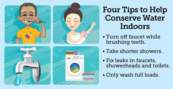
April is Water Conservation Month. This month is traditionally one of the driest of the year and marks the peak demand season for public water suppliers.
|
This is the economy way to cruise. No obstructed view! Thank you Heather.

This long overdue dredging is very welcome, because the channel through this Problem Stretch seems to shift with each tide and, until the dredging proves otherwise, Cruisers Net still recommends mid to high tide passage.

Below is a link to information about the dredging of Jekyll Creek off Jekyll Island set to begin April 10 (date revised March 11, 2019). Crews will arrive Monday for staging. This has been a long time in the making. Jekyll Creek is one of the most shallow points in the Atlantic Intracoastal Waterway in Georgia and has not been dredged since 1998.
Additionally, the U.S. Army Corps of Engineers will be using two new techniques to manage dredge sediments. You can read all about it in the link below. Please don’t hesitate if you have questions. I’m also working on putting a short video together about this with some drone footage showing the locations referenced on the website. I expect to have that available tomorrow for TV stations and anyone else who’d like it.
You can read all about it here: www.coastalGADNR.org/JekyllCreek
Tyler Jones
Communications Specialist
Coastal Resources Division
(912) 262-3140 | M: (912) 230-9709
Follow us on Facebook
Buy a fishing license today!
Click here to sign up for CRD news delivered to your inbox
—————————————————
A division of the
GEORGIA DEPARTMENT OF NATURAL RESOURCES
3/12/19 Jekyll Creek dredging pilot project set for April
Brunswick News
GEORGIA
Dredging in Jekyll Creek begins this month
News4Jax
Jekyll Creek Dredging Information Video
Dredging in Jekyll Creek begins this month
WJXT News4JAX
Big dredging project underway in Jekyll Creek
WJXT News4JAX
![]() Click Here To View the Cruisers’ Net’s “AICW Problem Stretches” Listing For Jekyll Creek
Click Here To View the Cruisers’ Net’s “AICW Problem Stretches” Listing For Jekyll Creek
![]() Click Here To Open A Chart View Window, Zoomed To This AICW Problem Stretch
Click Here To Open A Chart View Window, Zoomed To This AICW Problem Stretch
AREA SPONSORING MARINA
Click Here To View the Cruisers Net Georgia Marina Directory Listing For Jekyll Harbor Marina
Click Here To Open A Chart View Window, Zoomed To the Location of Jekyll Harbor Marina


Be the first to comment!