Cruisers Net publishes Loose Cannon articles with Captain Swanson’s permission in hopes that mariners with saltwater in their veins will subscribe. $7 per month or $56 for the year; you may cancel at any time.
Another waterfront property owner shows his distain for sailors trying to enjoy the cruising lifestyle. Actually, the Cyclops doesn’t play a role in the reimagined Odyssey. This work, Odysseus and Polyphemus, is an 1896 oil painting by the Swiss artist Arnold Böcklin, now display at the Museum of Fine Arts, Boston.
Henk van Oosten is a Dutch sailor and professional predictor of the future. When van Oosten retired from his job as an innovation expert, he combined sensibilities from both vocation and avocation, reexamined historical assumptions and proceded to rewrite The Odyssey.
Why Is This of Interest to Sailors Today?
The author assumes an early Western European maritime culture with bluewater-capable craft plying trade routes outside the Mediterranean.
He posits a lost system of celestial navigation more akin to traditional Polynesian methods but not exactly that either.
One of the greatest works of literature of all time, The Odyssey is also one of the earliest examples of a sequel. Writing around 800 years BC, Homer chronicled an epic war of Greeks versus Trojans in his poem TheIliad. The blind Greek poet hooked his audience: The war was caused by Helen, the unfaithful queen with a “face that launched a thousand ships.”
With the release of the Christipher Nolan movie “The Odyssey” last week, a massive amount of attention is being paid to the story.
Odysseus, the central figure in The Odyssey, was fresh from winning the Trojan War with his idea for the “Trojan horse” ruse de guerre in The Iliad. If you think of the Greek heroes of that war as celebrities such as, say, the Beatles, Odysseus would have been “the clever one.”
What van Oosten had done in a series of academic papers and a book was to upend the Homeric versions and create an entirely different narrative, set not in the Greek world of the Eastern Mediterranean but the Atlantic Ocean.
In van Oosten’s retro-futuristic imagination, Odysseus takes a ten-year lap around the Atlantic, to the Caribbean, then the Bahamas, Florida and the Azores before returning to his kingdom in southwestern Spain.
Hilariously, van Oosten identifies Florida as possibly the Hades of Homer’s account. That is, a Hell on earth.
Van Oosten was inspired by a 1990 book that posited Troy as a fortress in England, not what is now Turkey. Speaking to Fiona Cameron Lister in a July 22, 2020 story on the Medium website, Van Oosten said:
As a scientist, I disliked the fact everyone was saying the same thing about Troy — that it was Greek and on the coast of Turkey. The few people saying something different and that the Odyssey was possibly on the Atlantic were completely dismissed by classical historians and archaeologists…In searching for other perspectives to interpret the Iliad and the Odyssey, I am taking my own approach. As a reader, but also as a traveller and sailor.
Van Oosten’s inspiration was the shield of Achilles, another Trojan war hero conventionally assumed to have been Greek. According to Homer, the shield was made by a god for Achilles and decorated along its rim by a depiction of Oceanus, now called the Atlantic Ocean. The waves of Oceanus surround a dome of the sky with the sun, moon and four constellations.
Which can be used, van Oosten theorizes, for navigation to guide voyagers on the somewhat circular route still used for small boat voyages from Europe to the Caribbean and back. The fact that the Oceanus motif rims the circular shield suggests the Gulf Stream, he said.
Haphaestus, Greek god of fire and blacksmiths, made this shield for Achilles.
The Iliad records the first reference in history to celestial navigation. Homer describes the nymph Calipso giving Odysseus sailing directions using the very same constellations on Achilles’ shield, according to van Oosten:
Ocean navigation is determined, more accurately than by the sun, by constellations on the Achilles shield. Using the SkyMap astronomy software, it is possible to study the night sky in 1400 BC. The Great Bear is always in the north. If there are two stars on the horizon perpendicular to each other, that is the right course.
Stars Like Range Lights
To the west in winter is the setting Betelgeuse (Orion) and directly above, Procyon (Canis minor). In 1400 BC, this range marked the route from Boa Vista in the Cape Verde Islands to Guadalupe in the Caribbean.
In the summer of 1400 BC, heading towards the home port in the east, there is the rising Saiph (Orion) and Aldebaran (Hyades) directly above it. To van Oosten, Ithaca was not a Greek city state; it was in Southwestern Spain at the mouth of the Rio Odiel and Rio Tinto, site of present day Huelva.
Odysseus’ Imagined Route
As you can see, the reimagined Odyssey does follow the currents like the ocean-river depicted on Achilles shield. Coastal cruising is indicated by dotted lines, while the ocean-crossing passages are straight lines, aligned with the ranges depicted in the star charts above.
The story is pretty involved, of course. Epic, you might say. So one of van Oosten’s papers is included below for those who want to get deep in the weeds, or you could read van Oosten’s book on the subject.
Helen of Troy doesn’t exist in van Oosten’s narrative. The Trojan War is a powerplay between various peoples along the Iberian Atlantic and British Isles involved in the mining and distribution of tin. Tin was perhaps the most strategic commodity of the Bronze Age since it was the element in bronze alloy that kept edged weapons sharp.
The absence of Helen doesn’t mean van Oosten entirely ignores the love angle. None of the mentioned Atlantic islands were populated in 1400 BC, according to conventional thinking, but the science is not definitive. That gives van Oosten the wiggle room to speculate.
In those places, Odysseus dallies with the same assortment of nymphs, witches and queens as had been assigned by Homer, thus maintaining a plausible explanation of why it took 10 years to sail from Cornwall in the Southwest England to his wife in Huelva.
The author and his book.
Covering nautical news, history and now legend, LOOSE CANNON encourages you to subscribe. It’s free, and there are no ads.
Fred Pickhardt’s Substack is free today. But if you enjoyed this post, you can tell Fred Pickhardt’s Substack that their writing is valuable by pledging a future subscription. You won’t be charged unless they enable payments.
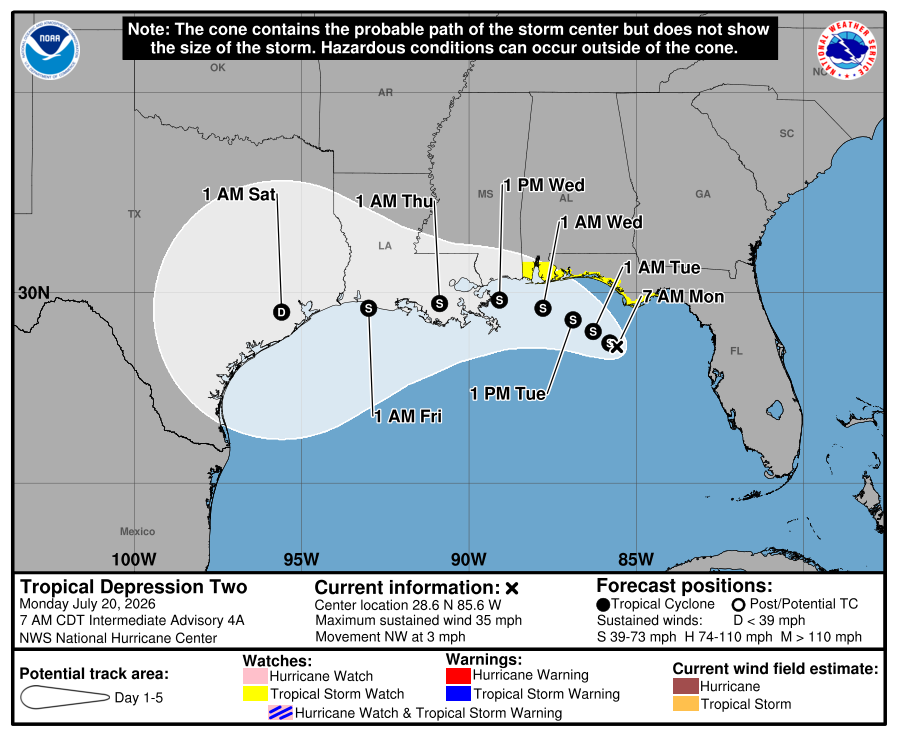
TD2 at 5pm EDT, was centered near 28.7N 85.8W with max winds of 30 KT with a minimum pressure of 1005 mb. The strongest winds are currently south and east of the center. The low-level center is drifting northwest at only 3 knots and is forecast to move slowly northwestward to west-northwestward for 36 h or so, followed by a turn toward the west.
The depression is experiencing moderate northeasterly shear, and these conditions should continue for another 18-24 hours, after which, the northeasterly shear should increase, and cause the system to weaken. The peak intensity forecast is 45 knots in 36 hours, however, wind shear could keep that somewhat lower.
Tropical storm conditions are possible in portions of the Gulf Coast from the Florida Panhandle westward to southeastern Louisiana Tuesday and Wednesday. A storm Surge Watch is in effect for the Alabama, Mississippi, and southeastern Louisiana coasts.
Areas of flash flooding will be possible through Friday along portions of the Gulf Coast and adjacent inland locations from western Florida north of Fort Myers to the Middle Texas Coast, including southern portions of Alabama, Mississippi, and Louisiana.
Over the weekend, the disturbance over the eastern Gulf became Tropical Depression Two. It remains a weak feature south of Panama City, Florida.
It now looks like it will head westward instead of our way. The National Hurricane Center calls for it to move into Louisiana Wednesday afternoon as a weak tropical storm. So, it won’t have any effect on us through the first part of the week. Some computer models show moisture from it being pulled toward us later this week by a cold front moving in. That would be nice; we need the rain.
It’s quiet over the rest of the Atlantic still. The tropical wave near Cabo Verde on Friday is now over the middle of the tropical Atlantic along 40° west, but there is little thunderstorm activity with it. Another wave moving off of Africa today will struggle against dry, stable air and vertical wind shear.
The above loop of visible satellite imagery above shows several features of interest across the North Atlantic and eastern U. S.:
Tropical Depression Two over the northeastern Gulf.
A tropical wave near 40° west in the tropical Atlantic
A band of clouds over North Carolina, Virginia, Tennessee, Kentucky and the Atlantic associated with a stationary front.
Smoke from Canadian wildfires is spilling southward over the middle of the Atlantic, all the way into the deep tropics.
Stay prepped; hurricane.sc is the place to go for prep advice.
Our Weather This Week:
The front we hoped would bring us active weather early this week has stalled farther north than expected. It’s close enough that the northern half of the state will see substantial coverage of afternoon thunderstorms through Tuesday, and a locally severe storm with damaging wind is possible. A stray storm can’t be ruled out further south, but they will be isolated. Temperatures will remain near to a few degrees above average.
We remain on track to see a more substantial cold front move through on Wednesday afternoon and evening. With that comes more widespread storms and the risk for locally severe storms, especially across the north. Damaging winds will be the primary concern.
It’s looking more likely that the front will stall over us later in the week now rather than push south. There’s a chance that the Upstate sees a nice day with low humidity on Friday, but don’t count on it. Otherwise, we’ll see limited sunshine with widespread showers and thunderstorms, mostly during the afternoon. If tropical moisture from TD Two becomes involved, torrential downpours and a flash-flooding risk would become a concern.
Frank Strait Severe Weather Liaison S.C. State Climate Office
South Carolina Department of Natural Resources 260 D. Epting Lane West Columbia, SC, 29172
Fred Pickhardt’s Substack is free today. But if you enjoyed this post, you can tell Fred Pickhardt’s Substack that their writing is valuable by pledging a future subscription. You won’t be charged unless they enable payments.
Tropical Depression Two, has formed in the northeastern Gulf of Mexico with initial maximum sustained winds of 25 knots and a minimum central pressure of 1011 mb.
Current Status
Location: 28.0N, 85.3W (Northeastern Gulf of Mexico)
Current Movement: North-northwest at 3 knots
Initial Intensity: 25 knots (30 mph)
Minimum Pressure: 1011 mb
Expected Track and Timing
TD 2 is forecast to drift very slowly northwest, approaching the Florida Panhandle Monday and Tuesday before turning more towards the west.
Wind Intensity Forecast
TD 2 should slowly strengthen reaching tropical storm intensity in about 24 hours peaking near 50 knots midweek. Rapid intensification is not likely due to dry air and wind shear.
Primary Hazards and Warnings
Wind: A Tropical Storm Watch is active for parts of the Florida Panhandle.
Flooding: Heavy rainfall threatens flash flooding through Thursday along the eastern and central Gulf Coast, spanning from western Florida into southern Alabama, Mississippi, and Louisiana.
Cruisers Net publishes Loose Cannon articles with Captain Swanson’s permission in hopes that mariners with saltwater in their veins will subscribe. $7 per month or $56 for the year; you may cancel at any time.
Starring as Odysseus’ flagship, Draken sails along, looking all Bronze Age Greekie without her dragon’s head stem.
Last month, Loose Cannon poked fun at the folks moaning about a black woman playing the role of Helen of Troy in the movie “Odysseus.” These folks had obviously been hoping for someone more like Nicole Kidman. “The poet Homer may have been blind, but that doesn’t mean he was colorblind,” I wrote in jest.
Last night, we attended the film’s opening at our local theater, and I can testify that 1. The movie was breathtaking, and 2. Black Helen (Lupita Nyong’o) was a minor character with only a few minutes of screen time that hardly mattered.
Whereas Odysseus’ ship was a major character, she being the vehicle that transported these Trojan War veterans from one nightmarish disaster to another. (Forgive the trivialization, but the movie harkened back to cruising the New England coast in my old wooden sloop, during which we faced “a crisis in every port” of engine failures and near sinkings.)
The Bronze Age penteconter was played by Draken, a replica of a 10th century Viking longboat. As I jokingly pointed out, this choice was more a-historical than a black Helen. The Vikings built lapstrake hulls, while the Greeks stuck with carvel planking. Truth be told, the distinction was hardly noticeable on screen, and I shall return to Draken’s performance shortly.
But First
Predictably, a few of my own readers last month fell into the “I like white” camp, not from racism but a nerdy devotion to Homer’s sacred text. I rarely debate readers anymore. I have become convinced that you should be able to have your say without an author feeling he or she has to nitpick back at you. But this time I felt these grown-up prep-school grads had entirely missed the point.
As I explained to one skeptic, the Odyssey is really akin to a fairy tale, albeit an epic one. Fairy tales are stories where wolves and pigs can talk and witches are real.
The narrator began last night’s movie by telling us that the events of the Odyssey happened “in a time of magic.” That plays out as you watch scenes of goddess Athena walking among us, a one-eyed giant, a witch or two, monsters and deadly sweet-singing mermaids.
But, no. Helen’s got to be milky white—Irish looking, if possible.
Let me go into some background about Helen that was not included in Homer, but would have been known to everyone listening in his audience: Helen was hatched from an egg.
Yeah, Zeus yearned for a little lovin’ from a human woman named Leda, who happened to be queen of Sparta, so he came down to court the lady the way one does. He took on the form of an oversized swan, swept down from the sky and raped her. (The New Testament God took a more nuanced approach when he sent the Holy Spirit in the form of a dove to impregnate Mary—via her ear in one telling.)
William Butler Yeats described the rape in his poem “Leda and the Swan,”¹ which begins:
A sudden blow: the great wings beating still
Above the staggering girl, her thighs caressed
By the dark webs, her nape caught in his bill,
He holds her helpless breast upon his breast.
So, in this 1920s depiction by Tadé Styka, Zeus is black and Leda appears to be disturbingly willing.
So, with dad being a bird and all, Leda was unable operate her gestation machinery in the conventional way. Instead, she laid a clutch of eggs, one of which housed embryonic Helen. Pray tell, amigos mios, what color should a person be who was hatched from a friggin’ egg?
In a July 16 article for Slate, writer Myke Cole described the same phenomenon, except from the point of view of military history buffs who were fussing over Director Christoper Nolan’s choice of costumes, armament and fighting tactics:
Nolan didn’t care. He’s making a movie about a myth, not a YouTube video about military history. In selecting the Odyssey, he is clearly focused on rendering one of humanity’s great stories relevant for the widest audience possible, not with gratifying the niche concerns of purist military historians like me, a vanishingly small fraction of viewers. In the screaming over historical inaccuracy, these critics reveal the truth—the loneliness that nerdy obsessives like us feel when we are forced to confront the fact that most folks don’t care about minutiae like we do.
Which brings us back to the boat, as we must do, to fulfill Loose Cannon’s mission statement. Draken was simply magnificent, even as an anachronism in Hellenic disguise.
Beach scenes depicted Odysseus and crew running for their lives back to their ship, clambering on board and rowing away chaotically from pursuing Cyclops or the Laestrygonian cannibals. It occurred to me that scenes such as these must have played out thousands of times during the Viking Era, but with Saxons and Franks instead of giants.
Having just lost a bank of oars from scrapping along rocks, the ship heads toward the whirlpool known as Charybdis, to be followed by an attack from the monster Scilla of the six heads. Rock and a hard place.
As fierce as they are portrayed, Norse raiders were also casualty-averse. They had to be, and the reason was simple. Each amphibious band had to maintain a certain number of hands in order to operate the ship—60 or 80 men to row, for example. They developed tactics and technology for the quick get-away, rather than risk too many casualties.
On a rocky shore, Vikings would drill a hole into a boulder, a hole big enough to loosely nest an iron mooring pin. These pins were likely fabricated with a big eye on top. Think: closed-loop oarlock. They would secure the bow of the longship to the pin with a long line, while deploying a stern anchor to secure the boat perpendicular to shore—barely afloat or barely grounded.
When pressed to escape a larger force, men on the bow could whip the line vigourously, flipping the mooring pin out of its hole, thus freeing the bow, as men aft hauled in the stern line, quickly moving the ship into deep water, while oarsmen took station.
For decades hopeful amateur archaeologists scoured the shores of New England, whereupon finding any hole in rock, would declare this as evidence of a Viking visit.
I will stop now, lest I be confused with a “lonely, nerdy obsessive.”
LOOSE CANNON covers hard news, technical issues and nautical history. Sometimes he tries to be funny. Subscribe for free to support the work. If you’ve been reading for a while—and you like it—consider upgrading to paid.
By William Butler Yeats
A sudden blow: the great wings beating still
Above the staggering girl, her thighs caressed
By the dark webs, her nape caught in his bill,
He holds her helpless breast upon his breast.
How can those terrified vague fingers push
The feathered glory from her loosening thighs?
And how can body, laid in that white rush,
But feel the strange heart beating where it lies?
A shudder in the loins engenders there
The broken wall, the burning roof and tower
And Agamemnon dead.
                                 Being so caught up,
So mastered by the brute blood of the air,
Did she put on his knowledge with his power
Before the indifferent beak could let her drop?
I was raised in and around the public, protected lands of the United States. Our homes were within the 6,000,000 acre Adirondack Park in Upstate New York; National Parks far and wide were always our destinations. We ogled the Grand Canyon with our grandparents, camped in National Forests, explored Wilderness Areas, climbed Monuments in Utah, saw vast tracts of California, wandered seashores of the Southeast, always appreciating the unique and often endangered creatures each contains.
Utah sunrise. Lake Powell, Glen Canyon National Recreation Area. Author.
My father achieved his Doctorate in education, but throughout his life told us he should have been a Forest Ranger instead. Less money, more life. He did what was expected of him, a high-ranking job in education, or at least that’s how I look at it now that I can no longer ask him.
US Geological Survey, each color is a level of Protected Public Lands. I feel fortunate that my home country has set these places aside.
What follows must be one of the first stories I ever wrote and kept, perhaps two dozen years ago and in the third person, which I rarely use now. Predictably, it’s about a National Park and is presented here largely un-edited. I stumbled across a print copy and typed it in as a powerful reminisce of my transformational summer job three dozen years ago…. hard to believe it’s been that long. ~J
THE DECISION
She had repacked the car, taken her last exam, filled the gas tank, had the oil changed. It was late, early morning, in fact, when she pulled up to her boyfriend’s house to say goodbye. His sciatic nerve had acted up and he could not move from the bed. It was an awkward, weird conversation. He thought she was making a ridiculous mistake and told her as much. They parted, she knowing it was for the last time but not saying that out loud.
After leaving him she sat at the curb, both hands on the steering wheel, making sure she was ready. It wasn’t her first solo road trip, all those to and from Arizona were longer, but this one takes her far from everything she has known. The ivy covered walls loomed above the residence as they are supposed to at these old, renowned colleges. She had spent the winter of her Junior year interviewing with Corporate Recruiters, just as her classmates had, receiving an offer from Hilton and Marriott for a Summer Internship in big hotels in big cities, all expenses paid. Great resumé material; it’s what her counselor recommended she do. In fact, it’s what everyone recommended she do, and what everyone expected her to do.
But back in March, she had come across an unlabeled folder in the placement office that contained a flimsy three-fold brochure. The pictures were fantastic, too good to be true, she thought as she dialed the number. An elderly gentleman on the other end of the phone seemed surprised that she had found him, took her information and mailed her an uncomplicated two-page application which she promptly returned, applying to be a bartender, her favorite, most lucrative job in the industry. No high heels, no nylons or business suits, no internship to write about, no rotation through the various departments of some anonymous hotel. Probably not great resumé material. Her friends told her she was crazy, throwing her career away, putting herself another year farther from making the big bucks. Big, big, big. Big business, big careers, big hotels with thousands of rooms, dozens of restaurants and hundreds of employees. Big decisions, or so they seemed at the time.
She put the car in gear and drove west; the toll booths were lit but empty. Exhausted from making a decision no one agreed with, she pulled over at dawn somewhere on New York’s Southern Tier Expressway until an officer rapped on the window. Suddenly wide awake and ready to get gone, she continued the 2,700 mile, thirty-five hour drive, spending the night in Fargo, North Dakota. One gentleman at a gas station commented that he had never seen a car like hers before; it was an aging Mazda RX-7 and she was rendered speechless. She smiled at him, thinking of her classmates at Cornell. “Where in the hell is Glacier National Park?” they had asked her incredulously when she turned down the internships.
At the Montana border she still had hundreds of miles to go, and the first exit, honestly, is called Home On The Range. She laughed out loud, stopped and photographed the sign; she was a tourist, after all. The sun was shining and she pulled over on State Route 200 for a bite of lunch. Tremendous Black Angus cattle grazed nearby and gentle breezes blew the prairie grasses just as they did in all the stories she had loved as a child. When she started the engine, it dawned on her that no vehicle had passed in either direction for the thirty minutes or so she had been eating and strolling. The speed limit was 75. That was a lot of miles between her and the next person in either direction. A lot of miles. If you ever want to feel small, go to Eastern Montana and pull over wherever you wish. It’s pretty much just you and God, no matter what form of religion you do or don’t believe in.
The tiny hotel in Great Falls was the least expensive place she had ever stayed in her twenty-one years of life and one of the cleanest; the phone, rotary dial. Nervous because tomorrow she was to meet the elderly gentleman who had answered her call, sleep was elusive.
May 25, 1990 dawned clear and fabulous, a chilly frost lay on the car. Wondering if she had packed the right wardrobe, she headed Northwest. The longest and most colorful train she had ever seen was running along the north side of the narrow two-lane highway, and in the distance the Rockies appeared, white with winter snow. When those Burlington Northern cars crossed an overpass and framed the bottom of the mountain range, the tourist stopped. She would never forget that sight, and the enlarged photograph has been with her ever since.
She entered the park at Babb, Montana, and headed up a thirteen-mile long dead end road, an hour and a half from any services except a tiny convenience store on the Blackfoot Reservation. She turned left into the hotel, crossed a bridge splashed by roaring rapids and surrounded by graying snowbanks. Many Glacier Hotel, with two hundred rooms, one place to eat and one place to drink took three years to construct in 1915 by The Great Northern Railway. Instead of bartending, she was in charge of the one place to eat, a football-field sized dining room serving 700 meals daily with fifty-five employees. None of that mattered. Her pay was $214 for a six-day work week, and that didn’t matter either.
Many Glacier Hotel is on the left side of the photo. Credit NPS. You see why it triggered my wanderlust.
The restaurant manager’s room was in the “Crow’s Nest” above the atrium. Five flights up, her view and the one she remembered so well in the brochure matched perfectly. Swiftcurrent Lake was below, Grinnell Glacier to her left, fantastic peaks and valleys in every direction. The snow melted after a final blizzard brought snow in around the windows on June 11th. Grizzlies showed themselves every day, flowers bloomed, waterfalls ran.
It was, indeed, too good to be true. Not another doubt ever crossed her mind about that summer job decision. It wasn’t big. It was perfect.
The left two windows in the main peak were my room. Heaven on earth. I remember being amazed how few people used the balconies. TripAdvisor 2018.
All of the photographs I tell you about here are inaccessible right now, 35mm, print only, tucked into a storage unit as my old wooden sailing yacht rocks along in a life far, far different from the time I spent out West. After graduating from Cornell Hotel School, spring of ‘91, I became Beverage Manager at Yellowstone National Park’s flagship Lake Hotel, then moved to Colorado, spending twenty-six years there, Catering from a little organic farm on the stunning Western Slope after an I-just-have-to-make-sure-this-is-not-for-me stint at a corporate skirts-required Hilton in the Denver Tech Center and a beloved adventure working Food and Beverage at Copper Mountain Resort where my skis hung in my office.
If you have not experienced Glacier, as those familiar call it, GO. Drive Going To The Sun Road. Hike amongst the Beargrass. Watch the Mountain Goats play on vertical granite. GO. It’s officially Waterton-Glacier International Peace Park, a unique cooperation with Canadian National Park Waterton Lakes, which is stunning, too. GO. But don’t tell everyone!
What were you doing the summer of 1990? Or were you just a gleam?? ~J
If you believe other people will enjoy my stories, please take a quick sec to tap that heart and the little recycle symbol which sends these words out to the world somehow, which is how I get subscribers and fans. Even better, leave me your own reminisce! I answer every one and always enjoy the engagement. Thanks!
Fred Pickhardt’s Substack is free today. But if you enjoyed this post, you can tell Fred Pickhardt’s Substack that their writing is valuable by pledging a future subscription. You won’t be charged unless they enable payments.
Upper level low pressure across Florida and the far eastern Gulf now extends into the lower atmosphere, and a weak surface low.
300 mb wind
This system has been designated a tropical disturbance (Invest AL91) by NOAA NHC. There is now a 40% chance for this system to become a tropical cyclone over the next 3-7 days as it moves slowly northward.
NOAA Satellite Image
Disorganized thunderstorms, strong wind gusts, and frequent lightning are occuring between 83W–84W and across the Florida Gulf Coast, mainly associated with an upper-level low. An Air Force reconnaissance flight scheduled for Sunday, July 19 to investigate the system.
Watching the Gulf, More Severe Thunderstorms Possible
Weather Alert – July 17, 2026
Watching the Gulf
Finally, we again have some signs of life in the Atlantic tropics. There are two areas of interest out there today. One is close to home, and the other is way out there over the eastern Atlantic.
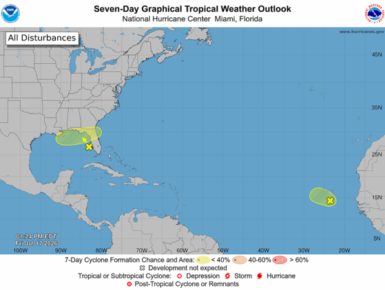
Here’s the National Hurricane Center’s (NHC’s) Seven Day Graphical Tropical Weather Outlook from Friday afternoon.
Our primary concern is a blob of thunderstorms that has erupted over the far western Gulf over the last 24 hours, associated with an upper-level low over the area. The area could (NHC gives it a 20 percent chance) evolve into a tropical cyclone as it wanders around the northeastern Gulf. Whether or not it becomes a tropical depression or storm, the most likely track will be over Florida and near the East Coast. The impacts will depend on the track and how strong of a feature it becomes, both of which are very uncertain right now. It could remain too far offshore to affect us, a disorganized plume of moisture that contributes to rain along our Coastal Plain early next week (ideal because we need the rain) or a tropical depression or weak tropical storm that brings our coastal areas heavy rain, gusty winds, a small storm surge along with a risk for isolated tornadoes. Another alternate scenario some of the computer models show is that it drifts westward instead and becomes more of a concern for the central Gulf Coast than for us. This feature will definitely have our attention over the weekend; if it will affect us, that will happen Monday night through Tuesday night.
The loop of visible satellite imagery above shows several features of interest across the North Atlantic and eastern U. S.:
Thunderstorms are clustering around a developing low-pressure area over the northeastern Gulf.
Low pressure along a tropical wave is centered near Cabo Verde and moving northeastward.
A tropical wave is near 45° west, drifting westward slowly.
Bands of smoke from large wildfires west of Hudson Bay can be seen from Michigan and Ohio through the Mid-Atlantic region and over the Atlantic north and northeast of Bermuda.
The other area of concern is over the eastern Atlantic, where a weak low-pressure area has formed along a tropical wave that recently emerged from Africa. It looks decent on satellite imagery with a swirl of clouds and some associated thunderstorms. However, it’s moving northwestward toward dry and stable air. So, it’s a long shot (10 percent chance, according to NHC) to become a tropical depression or a weak tropical storm while causing squally weather in Cabo Verde this weekend. After that, it likely remains a weak feature as it moves toward the central North Atlantic. It looks, to borrow a phrase from my favorite author, mostly harmless.
There are no other features of interest over the Atlantic today. A tropical wave is near 45° west over the middle of the tropical Atlantic, but it is very weak and unlikely to raise any ruckus in the coming days as it drifts westward.
Since there’s a small chance we’ll have to deal with a tropical storm next week, you’ll want to use the weekend to make sure your hurricane kits are properly stocked. As always, hurricane.sc is the place to go for prep advice.
More Severe Thunderstorms Possible
Another weekend, another cold front: our late week heat will ease through Sunday as another cold front moves in. We’ll see sparse coverage of routine afternoon thunderstorms this afternoon and Saturday afternoon, though keep in mind that sometimes our summertime storms become severe with isolated damaging wind. The Upstate has the best chance to see a severe storm.
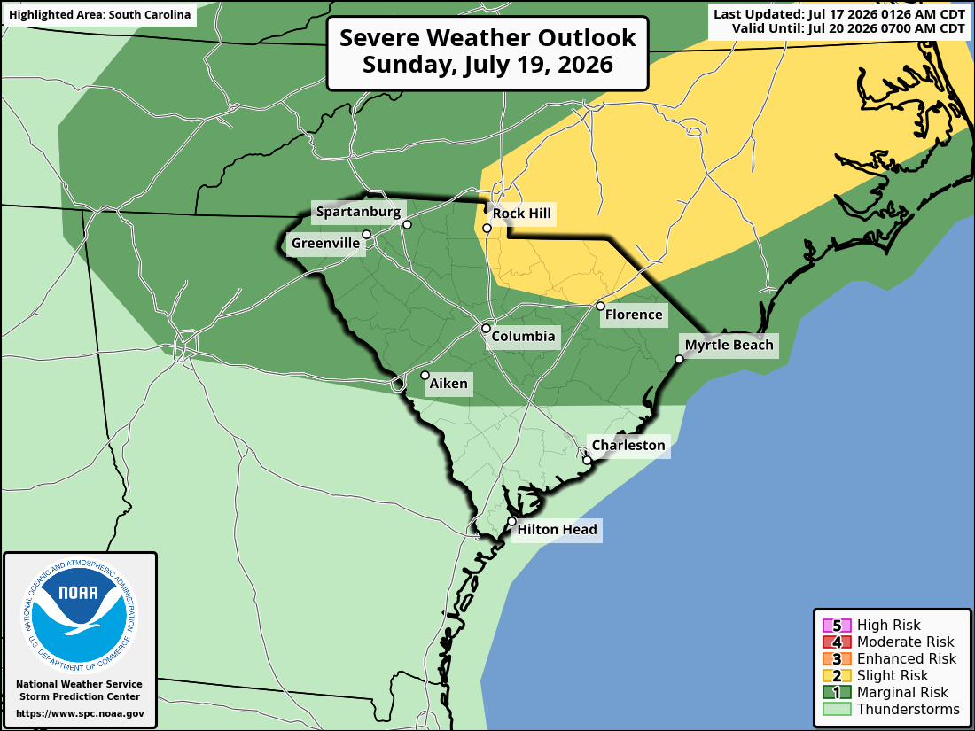
By Sunday, the approaching cold front will be over our tomato-and-vinegar-loving northern neighbors, which will increase afternoon thunderstorm coverage over the northern half of our state and increase the severe storm risk in that area. Locally damaging winds will be the primary concern with the storms.
Here’s the Storm Prediction Center’s Day 3 Severe Weather Outlook for South Carolina, covering Sunday and Sunday night.
The front will become stationary and start to decay over us on Monday, so look for widespread showers and thunderstorms that could start to pop up before midday. Once again, a locally severe storm is possible. It will be the least hot day of the next few with highs only in the upper 80s and lower 90s.
Tuesday brings us less widespread thunderstorms and more heat; highs will be 90-95° across the state. However, the feature in the Gulf is the wild card for the day, as we’ll feel its impacts Monday night through Tuesday night if it tracks toward us. Our coastal areas are most likely to see it cooler and wetter; again, low-end wind, surge, rain and tornado risk is the worst-case scenario near our coast if the feature becomes a tropical cyclone.
On Wednesday, we have better-than-usual agreement among the computer models that another cold front will move in. The front is likely to bring showers and thunderstorms, and there is a chance of severe storms again if it moves through during the afternoon and evening.
We have a chance of unusually pleasant weather for at least part of the state later next week, as the weather pattern then will favor the cold front pushing much farther south than we typically see in July. Computer models tell us the front will stall to our south and east Thursday into Friday, allowing a drier air mass to move in with temperatures running near or slightly below average. 90° with low humidity is a pretty good deal for us in late July, so I’ll be rooting for that. However, climatology isn’t on our side, so don’t be surprised if the front stalls farther north and west than the models indicate, resulting in at least part of the state seeing scattered showers and thunderstorms. Of course, with most of the state still in a drought, more rain chances are a good deal, too.
On the satellite loop above, you’ll see areas of smoke from wildfires in Canada streaming by to our north. Some of it is sneaking into the Pee Dee; you may notice some haziness that way this afternoon. The smoke will mostly remain north of us through the weekend but it may shift southward toward us next week, especially later in the week.
Speaking of drought, if you have ever wondered how we define drought and its severity, I can tell you about an opportunity to learn more. The National Drought Mitigation Center (located at the University of Nebraska) will hold an online workshop to explain how the U.S. Drought Monitor works. If you’re interested, you can read more and sign up here: NDMC’s U. S. Drought Monitor 101 signup. The workshop will be held on August 13, from 3-4 p.m. Eastern Time.
Frank Strait Severe Weather Liaison S.C. State Climate Office
South Carolina Department of Natural Resources 260 D. Epting Lane West Columbia, SC, 29172













Be the first to comment!