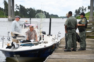
As Richard Ross warned in early May, Caution Still Needed, Sean Foley reminds us that, despite ongoing dredging in the creek, a sharp eye on your depth finder is a wise choice until the dredging project has been completed. And like TowBoatUS, mid to high tide is Cruisers Net’s recommendation for safe passage.
If you draw five feet or more, enter Jekyll Creek from the north only at or very close to peak high tide. Our depth finder showed less than 6 feet of water at Marker 17 an hour before the afternoon peak high tide. We draw 5 feet so we had less than a foot of clearance. The ongoing dredging operations will greatly improve this situation, but until the project is completed use caution and time your entry properly. The dockmaster told me it will take another few weeks to complete the project. I had called TowBoat US for local knowledge before entering the Creek and he suggested a mid-tide or higher entry would be ok. He was correct, but I’d say make it closer to peak high tide. By the way, after I submitted my comment I spotted a couple of skeptical responses to the early May advisory from two other skippers. The answer here is that the dredging equipment is by necessity occupying the Jekyll Creek channel around markers 17 and 19, forcing boat traffic into the western shallows. The dredging crew has advised Tow Boat US to tell deep draft vessels to pass as close as safely possible to the west side of the dredging barge/equipment. Cheers, Sean Foley
The Gulfport Historical Society continues its educational activities for the City of Gulfport, which always has a full calendar of events for all ages and is home to Gulfport Municipal Marina, A CRUISERS NET SPONSOR, located on the northern shores of Boca Ciega Bay, easily accessible from the Western Florida ICW, just north of Tampa Bay.
At long last, the museum reopens! Join us? Join us for a very special grand re-opening of the Gulfport History Museum!
After months of renovation following last summer’s Labor Day fire, our museum is in beautiful shape and we’re excited to officially open to the public on June 1, 2019.
We’ll be open to everyone this Saturday, June 1, from 10 a.m.-2 p.m. for a meet and greet with volunteers, board members and our first-ever operations manager. You can learn more about GHS’s plans for the coming year and our ongoing efforts to digitize and preserve Gulfport’s town records, all while enjoying our beautifully restored museum space. Our exhibit The Gabber: 50 Years of Hyper-Local News will be back on display for your enjoyment.
We’ll have a light buffet brunch, courtesy of Stella’s, with some muffins from A Friend Who Bakes. We always welcome dogs and well-behaved children.
Our thanks to Steve and Jane, and others – see comments below- for these kind words posted on AGLCA’s Forum for one of our longtime CRUISERS NET SPONSORS, Dowry Creek Marina. The marina is under new management and ownership by the Zeltner family who want to roll out the red carpet to transients, doing whatever you might need during your visit to this highly praised and transient friendly marina lying off the AICW/Pungo River north of Belhaven, NC. Our thanks to Jeff Irwin (see comments below) for the two photos from Dowry Creek.
Just left Dowry Creek Marina in Belhaven, NC, this am. Had a great visit and wanted to let everyone know. It’s well run, has brand new docks, free laundry, courtesy car, pool, and protected water. Jeff does a great job and we will definitely be back. Steve and Jane McKinney M/V Sabbatical 36′ Albin
Dowry Creek was God sent to us. We stopped for fuel and the dock help was great as the wind was not cooperating. After fueling my port battery decide to give it up. The owner let us stay on the fuel dock for the night then drove me to the Advance auto to get a new 8D battery, and helped me lift it out and the new one into position. It was clean and well kept and friendly. Well family run business. Kurt & Barbarajean Walter M/v “in HIS time”
I was going to second this but was beaten to it. So I’ll “third” it. It’s the best run little marina we’ve been to and have stayed there the last couple times through that area. Phil/Karen Barbalace 2009 Mainship 40 Seascape
I’ll second that. I have stayed there twice last year. Going north and than again on the south bound journey. Great people nice place. Will use it again. Jeff Irwin
We also want to add to the positive review of this marina. The new owners are slowly rebuilding the docks, including new electrical pedestals.All the freebies listed in other reviews are as stated. There is supposed to be an on-site restaurant opening up in summer 2019; the building it will be in looks wonderful. One of the reasons we liked it so much was the attention of Jeff and his crew. We ended up having an extra day there, due to weather, and we were safe and secure. This place will only get better as time passes. Louise Anderson
Experienced cruiser and frequent Cruisers Net contributor Jim Healy shares his observations on the two route choices south of Norfolk. The Virginia Cut is part of the main AICW route via Great Bridge Lock and the Dismal Swamp Canal is the alternate route departing northeast Albemarle Sound northbound via Pasquatank River, Elizabeth City and South Mills Lock. The Canal rejoins the AICW at statute mile 7.1.
There are so many considerations… To say nothing of personal preferences…
The two routes are the “Virginia Cut” and the “Dismal Swamp.” There is no significant difference in the distances of the two routes, but the Dismal takes longer. The Virginia Cut can be done in one day. The Dismal Swamp route can be done in one day, but more usually will take two or more. It depends on what you want to see and do.
The Virginia Cut is a salt-water route suited to fast boats and boaters who are “in a hurry.” It is the eastern route, the “main” ICW, runs through Coinjock, where there are marinas, is used by go fast boats with big wakes and inconsiderate operators, and has a couple of bridges that can bring the pace to a prolonged stop. There is one lock at Great Bridge in Chesapeake, VA, that has about an 18″ lift. That bridge operates on the hour. It’s tidal north of Great Bridge.
What’s good about the route? 1. Fast 2. Coinjock 3. Southern 1/4 of the route is beautiful.
The Dismal is a fresh water route through a cypress swamp with some old growth deciduous trees. It is the western route, suited to slow boats and boaters who are very comfortable taking their time. There are two locks, one at South Mills, NC, and on at Deep Creek, VA. Lift is about 8′, depending on Lake Drummond datum and tide on the north end. The locks operate 4 times a day, at 8h30, 11h00, 13h30 and 15h30. It’s 22 StM from South Mills to Deep Creek. If you clear into the system at 08h30, you have 5 hours to make the 22 miles to Deep Creek, which is less that 5 mph. There is a 6 mph speed limit on the canal. No wakes.
We are an 8 MPH boat. We depart Elizabeth City at 06h00 to clear into the system at South Mills at 08h30. People (usually sailboats) also anchor in the channel at the South Mills Lock if they can’t get going by 06h00. Anchoring in the channel is legal in the overnight when the locks are closed, but you must not interfere with traffic during the day.
The Dismal control depth is 6-1/2 ft. The usable width of the Canal is probably 70 feet. The crown of the forest does overhang the canal, and sailboats – all boats, really – will take their half out of the middle. There are some submerged logs. The trick is to stay 3/4 mile behind the boat in front of you – if there is a boat in front of you – so that anything that boat lifts off the bottom will settle back to the bottom before you get to that spot. No boat in front of you, just go slow. Many people complain of bumping something in the dismal. Many of them are “tailgating” boats in front of them. How to I know? I’ve see it over and over again.
What’s in the water in the dismal? 1. Nothing 2. Visible dead heads ranging in size from twigs to logs 3. Submerged larger stuff 4. Wildlife and sea monsters
We prefer the Dismal. We take our time. We enjoy the peace and quiet. We rarely hit anything, and we never hit anything at speeds above idle.
What’s better about the route? 1. Elizabeth City 2. No wakes, boater courtesy 3. NC Visitors Center and Nature Center 4. Ample free docking (albeit w/o services) 5. Robert Peek 6. The magnificent scenery and wildlife of the Pasquatank River
If you draw 5′ or less, you won’t have a problem. If you are patient, you won’t have a problem. If you stay well behind the boat in front of you, you won’t have a problem.
Yes, this has all been discussed many times. It’s a natural and inevitable part of the AGLCA spring ritual.
Cruisers Net is honored to be able to work with this five-star, customer-focused, family owned and operated organization. Watermakers Air and Staniel Cay Yacht Club have been synonymous to so many over the past years. Success is the driving element to its expanded service to the Bahamas and to its re-branding as Makers Air. Take a look at what you may do to add to your Bahamas experience. Can you say…” Wow !!” Staniel Cay Yacht Club, A CRUISERS NET SPONSOR!
There’s Something New in the Blue Skies Over the Bahamas
Watermakers Air has Re-Branded to
Makers Air
Still Providing an Unparalleled Travel Experience with A New Look
The story behind this story is filled with the passion of an enterprising gentleman, Joe Hocher, the developer of what we all know as the Staniel Cay Yacht Club, Exumas, Bahamas, and Watermakers, Inc. in Fort Lauderdale, a manufacturing company dedicated to the design, manufacture, and service of reverse osmosis desalination equipment. In the earlier years, Mr. Hocher flew around the islands in his Piper Cherokee Six, installing and servicing his desalination equipment; he affectionately became known as “Watermakers Air”.
Then, in 2002, Watermakers Air was officially launched in response to demand for reliable air service to the Out Islands of the Bahamas, operating as a Part 135-Charter for the specific purpose of flying passengers and freight.
For the past seventeen years Watermakers Air has been the preferred air service to the Bahamas from Ft. Lauderdale, FL. Growing from its initial operations servicing mostly Staniel Cay, Exumas, Makers Air is today’s premier air service to many of the Out Islands of the Bahamas.
Now you can make your island dreams come true…
Makers Air enhances your experience of travel by bringing back what it means to fly – the excitement of the great escape, togetherness with family or friends, and helping you relax as yesterday’s concerns fade into the inviting, crystal blue waters of the Bahamas.
The Makers Air “difference” runs deep. What resulted from Joe Hocher’s passion became a family-owned, strategically grown, premiere boutique airline, that believes in the value of the passenger’s experience and safety. Makers Air understands that the destination is not your only adventure – it’s also the exciting journey to get you there.
See these beautifully scattered cays from a “Makers” point of view
Sparkling blue waters dotted with small cays … So much to see, do, and enjoy.
And the flight over and back becomes so much of the total experience… and memory.
Today, Makers Air, a certificated On-Demand / Commuter Air Carrier, has taken its brand promise to the next level by creating a tailored passenger experience that is focused on customer service and connecting passengers to paradise. The company has grown to a family of 30+ employees with dedicated Scheduled Service, Charter, and Freight Departments, with a fleet of 4 Cessna Grand Caravans.
Makers Air proudly carries an Argus Gold Rating on its fleet of Cessna Grand Caravans. With various seating configurations, including an Oasis Executive Interior, they will make your travel as memorable as your destination.
Makers Air is based out of a private hangar at Ft. Lauderdale Executive Airport, convenient to all South Florida international airports. They offer a spacious, comfortable lobby with TV & WiFi, including the private, upscale Makers Club departure lounge for charter customers. You will enjoy complimentary snacks & beverages while also enjoying the lack of long security and baggage lines!
Reservations and freight offices are open 7 days a week and Makers Air is also pet-friendly!
Whether you are looking to take a vacation, fly to or from your boat, fly guests in or out, transport crew or parts or supplies, Makers Air is ready to provide you with exemplary service.
It is an honor to be able to work with such a customer-focused organization as Makers Air and the all the wonderful people of Staniel Cay Yacht Club.
Ready to kick back and start finding that one particular harbor…?
An increase in commercial shipping on the Waterway would have the disadvantage of increased larger vessels vs recreational ones and the advantage of possible better Federal and local maintenance of Waterway depths.
I hope water transport is used more .. particularly on the ICW.
Then maybe folks in charge will see the savings in cost of goods moved and spend some more on dredging and surveys so that that everyone might enjoy some better maintenance on the waterways.
As part of National Safe Boating Week, the South Carolina Department of Natural Resources offers these safety tips.
Boating safety tips and reminders
Do you know what you should do before you leave your home for a day on the water? Many of these steps are missed and can mean the difference between getting back home safely or not.
Before getting in the water
Before leaving, make sure you fill out a float plan and let people know where you’re going, what route your taking, as well as what time you expect to be back. You can download the United State Coast Guard app to fill out your float plan and share it electronically.
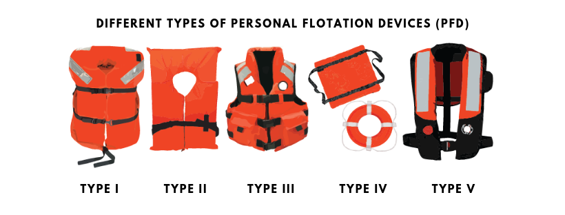
You’ll also want to get all your Personal Flotation Devices (PFD) together, make sure they are in serviceable condition AND are the correct size for all passengers, especially children. All PFDs should be stamped with “U.S. Coast Guard Approved” and include the type of PFD it is.
There are five PFD types:
Type I: Offshore Life Jackets:
Best for all waters where rescue may be delayed and will turn unconscious wearers to face-up position
Type II: Near-shore Vests:
Best for calm, inland water where a quick rescue is likely.
Type III: Floatation Aids:
For general boating or the specialized activity, such as water skiing, hunting, fishing, canoeing, kayaking and others. Good for calm, inland waters, or where there is a good chance for fast rescue.
Type IV: Throwable Device:
Can be a square style, or a ring buoy or horseshoe buoy mounted on deck.
NOTE– You must have one at arm’s length to throw over the side in an emergency.
Type V: Special-use Devices:
Manual units are activated by yanking a pull-tab. Both types, Hybrid inflation and Automatic inflation, of inflatables feature blow-tubes to provide a back-up method of inflation.
You should also check your fuel level and battery charge before heading out. If possible, have an extra battery for your boat. Make sure your lights are in good working condition on the boat AND trailer, as well.
In addition to PFDs, you’ll also need to have a fire extinguisher readily accessible and in good serviceable condition.
Also, remember to put the plug in.
On the water
Now that all that is checked-off, what should you know when you’re on one of South Carolina’s beautiful waterways?
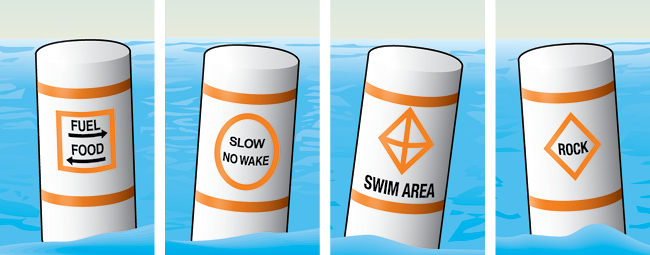
The first thing you should do is get familiar with the aids to navigation and buoy system in the area you’ll be in. Refresh your memory on what each symbol and color means.
Lateral markers will mark the edges of safe water areas, directing traffic within a channel. Think of them as the yellow lines you see on the road. A red marker indicates the right side of the channel, and green will be the left side as a boater heads upstream or enters from open sea. Remember, all boats approaching from the right have the right of way and should keep the course.
Non-lateral markers are navigational aids that give information other than the edges of safe water areas. The most common are regulatory markers which are white and use orange markings and black lettering. Non-lateral markers are found on lakes and rivers.
Information: Squares indicate where to find food, supplies, repairs, etc., and give directions and other information.
Controlled: Circles indicate a controlled area such as speed limit, no fishing or anchoring, ski only or no skiing, or “slow, no wake.”
The “no wake” zones will be marked by an official SCDNR logo
Exclusion: Crossed diamonds indicate areas off-limits to all vessels such as swimming areas, dams, and spillways.
Danger: Diamonds warn of dangers such as rocks, shoals, construction, dams, or stumps. Always proceed with caution.
While you can be prepared as much as possible, it won’t always stop something bad from happening. However, being prepared could keep the situation from being worse.
If someone does fall overboard, immediately turn the boat off and throw something that will float, like a PFD, raft or cooler to the person. You should have it easily accessible and not tied down. If your boat capsizes, stay with the boat! You will have a better chance of being seen by rescue crews.
South Carolina has the perfect conditions for pop-up thunderstorms during the summer. If you get caught in one, head into the wind and have everyone, including yourself, put on PFDs. Also, keep passengers low in the boat.
Don’t operate any watercraft while under the influence of alcohol or drugs. If you see any potential boating, fishing or hunting violations, call Operation Game Thief’s 24-hour hotline at 1-800-922-5431 to report it.
Once again, thank you to those who contributed to our Advocacy Fund, which allowed us to be represented in Tallahassee during the Florida legislative session. Our efforts were highly successful. Following is a recap submitted by our lobbyist:
“During the 2019 Legislative Session there were multiple bills filed that could affect cruisers’ interests including the freedom to responsibly anchor in Florida waters. There were multiple communities that attempted to further restrict anchoring. The City of Melbourne, for example, sought legislative language that would bypass the provisions that our Associations got passed 2 years ago which pre-empted all anchoring restrictions to the State level (i.e. no local governments can pass ordinances relating to anchoring, except for the narrowly-defined live-aboard vessels). Melbourne’s approach was to re-define the term live-aboard vessel so that it would apply to most vessels at anchor and therefore allow them to ban anchoring. This attempt was defeated despite strong lobbying efforts by the City and influential legislators. The City of Hollywood and others sought to ban anchoring in specific anchorages. This was also defeated, again, despite strong lobbying efforts by the City and influential legislators.
“Ultimately, the Legislature passed only one relevant bill, SB 1666 which awaits signature or veto by the Governor. This bill attempts to address the problem of long-term ‘stored vessels’ that are essentially abandoned in anchorages. Our Associations supported and helped draft these provisions. The bill defines the term ‘long-term stored vessel’ to mean a vessel which has remained anchored or moored without supervision or control for at least 30 days out of a 60-day period. It requires the Florida Fish & Wildlife Commission (FWC) to conduct a study on the impacts of long-term stored vessels on local communities and the state, and to present the report to the Governor and Legislature.
“The bill also provides a certain portion of vessel registration fees designated for use by the counties to be deposited into the Marine Resources Conservation Trust Fund to fund grants for derelict vessel removal. Funds not granted to local governments by a certain date in the fiscal year may be used by the FWC to remove derelict vessels.
“The bill also prohibits a person who leaves or abandons a derelict vessel from residing or dwelling on the vessel until it is permanently removed from state waters or returned to waters in a nonderelict condition.
“The bill also authorizes counties designated as rural areas of opportunity to create in freshwater water-bodies within their jurisdiction a ‘no-discharge zone’ where treated and untreated sewage discharges are prohibited for specified vessels. It requires vessel operators within a no-discharge zone to keep sewage discharges onboard for discharge at sea or onshore at a pump-out facility and imposes a civil penalty and declares the vessel or floating structure a nuisance and hazard to public safety and health if an unlawful discharge is made in a no-discharge zone.
“AGLCA, along with MTOA, SSCA and the DeFever Owners Association, was effective and influential throughout the Legislative Session, ensuring that proposed legislation did not impair the freedom of cruisers to responsibly access and utilize Florida’s waters, especially its anchorages. We also maintained a focus on policies that can help remove vessels that are derelict or at risk of becoming derelict.”
Our next task is to work during the off season to see if a compromise can be reached with parties that want to limit anchoring. Our hope is that we won’t have to continue to fight this year-after-year.
Kim Russo Director America’s Great Loop Cruisers’ Association


Be the first to comment!